Aktuelle Projekte
Auf dieser Seite finden Sie ausgewählte aktuelle Projekte, die Mitarbeitende des Schweizerischen Erdbebendienstes (SED) federführend betreuen oder an denen sie in zentraler Rolle mitwirken. Es handelt sich nicht um eine abschliessende Aufstellung, sondern um eine Auswahl zentraler und umfangreicher Projekte. Die Projekte sind nach ihrem Hauptforschungsfeld geordnet.
Interdisziplinäre Projekte
FEAR - Fault Activation and Earthquake Rupture
|
|
Despite intensive research, scientists cannot predict exactly when and where the next major earthquake will occur. The ERC Synergy project "FEAR" aims at a better understanding of the physics of earthquake processes. To this aims, researchers will generate small earthquakes under controlled conditions at a depth of more than one kilometre and on a scale of ten to one hundred metres. They will measure a variety of earthquake parameters using a dense sensor network and then analyse them. The consortium hopes to gain a better understanding of the dynamics of earthquakes. The new findings will also be used to advance experiments on the safe use of geo-energy and to improve the predictability of earthquakes. The experiments will take at the "Bedretto Lab", a rock laboratory in the Swiss Alps, built by ETH Zurich and the Werner Siemens Foundation. It offers FEAR a unique research environment. |
|---|---|
| SED Projektleiter | Prof. Stefan Wiemer |
| Finanzierung | |
| Zeitdauer | 6 years |
| Stichwörter | earthquake prediction, earthquake dynamics, safe use of geo-energy |
| Bereich | earthquake prediction, earthquake dynamics, |
| Link zum Projekt Website |
Opossum: Ultra-sensitive photonics accelerometers for next generation seismic sensor networks
The OPOSSUM project aims at the development and testing of accelerometers and acceleromter networks with the potential to outperform state of the art sensing technology. Accelerometers are powerful, highly versatile and cost-efficient tools used in a wide range of application with specific requirement in terms of frequency response and sensitivity. Accelerometers can record acceleration with frequencies of 1Hz to more than 1MHz. In seismology accelerometers are used in two subfields, among others:
Accelerometers can be deployed on concrete or steel, for example for structural health monitoring of buildings, dams, bridges or wind turbines; they can be deployed in deep boreholes, detecting micro-earthquakes during the reservoir creation of geothermal activity, oil and gas exploration and operations, or to monitor mining operation and the integrity of nuclear waste repositories etc. They can also be used as scientific instruments to better understand fluid-rock interaction or the initiation and propagation of catastrophic natural and induced earthquakes. The OPOSSUM project exploits theoretical and experimental advances in the field of opto-mechanics in the last decade as well as significant improvement on micro-fabrication and modelling of high-quality integrated photonics circuits (PIC) and ultra-high Q (UHQ) mechanical resonators. These two technological building blocks are at the core of a new generation ultra-sensitive accelerometers that are developed at the Centre Suisse d’Electronique et de Microtechnique (CSEM), with capabilities of exceeding the current generation of accelerometers in numerous ways. |
|
| SED Projektleiter | Linus Villiger |
|---|---|
| Finanzierung | SNF Bridge |
| Zeitdauer | 2021 - 2025 |
| Stichwörter | Ultra-sensitive seismic sensors; Optomechanics; High Q mechanical resonators; Integrated photonics; energy and exploration; structural health monitoring; Induced earthquakes |
| Bereich | Seismic sensor development |
CORE: sCience and human factOr for resilient sociEty
|
|
CORE is an EU project funded by the European Commission under Horizon2020 research and innovation programme and involves 19 partners in Europe. Its main objective is to make societies better prepared to face and overcome natural and human-made disasters. Through a transdisciplinary approach, scientists from different fields and various stakeholders from society are involved. The project will seek to put the citizens at the core of disaster resilience and preparedness, supporting communities to enhance their preparedness and rapid recovery. Defining at best the expected scenarios and the difficulties of individuals and socio-economic structures is essential to make recoveries more effective and efficient. Recommendations and guidelines from CORE will foster a culture of improved preparedness, adaptability, and resilience to risks. In addition, particular attention will be paid to the most vulnerable groups during such disasters: the disabled, the elderly, people with economic difficulties, women, or children. Great attention will also be paid to education in schools, training activities and communication through social media. |
|---|---|
| SED Projektleiter | Dr. Michèle Marti |
| SED Projekt Mitarbeiter/innen | Prof. Stefan Wiemer, Dr. Florian Haslinger, Dr. Banu Mena Cabrera, Dr. Michèle Marti, Irina Dallo |
| Finanzierung | EU Horizon 2020 research programme |
| Zeitdauer | 2021-2024 |
| Stichwörter | emergency management (operations), disaster preparedness, community resilience, natural and human-made disasters, decrease technological and industrial risks, population training, protection of citizens (goods and people), safety culture, artificial intelligence, cascading effects, vulnerable groups |
| Bereich | Rapid impact assessment, risk framework of cascades human behaviour, social media, risk perception, misinformation, cost-benefit analysis, early warning systems |
DemoUpStorage
|
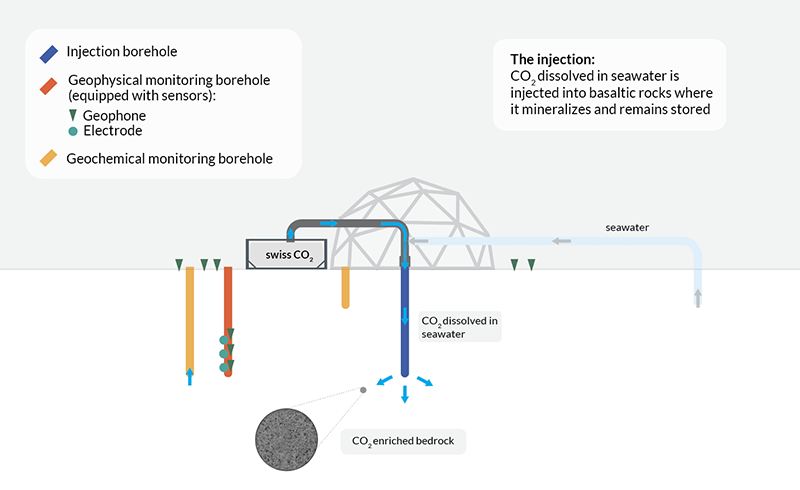
The Swiss Energy Strategy foresees CO2 capture and underground storage, possibly abroad, among the necessary measures to reach the net zero target by 2050. DemoUpCARMA, the partner project of DemoUpStorage, explores as one pathway to negative emissions the transport and storage of Swiss biogenic CO2 in Islandic basalt as well as this pathway’s potential for upscaling. Since a safe and permanent storage of the Swiss CO2 is an indispensable requirement, DemoUpStorage takes the lead in closely monitoring the injection and the dispersion of the Swiss CO2 in the Islandic underground at a site that has high potential for upscaling. For the injection, a novel technique is used, where the CO2 is dissolved in sea water instead of fresh water. The findings of DemoUpStorage will further advance the Swiss Roadmap for geological CO2 storage through knowledge acquisition and transfer, as well as capacity building. DemoUpStorage has the following objectives:
|
|---|---|
| SED Projektleiter | Prof. Dr. Stefan Wiemer |
| SED Projekt Mitarbeiter/innen | Dr. Alba Zappone, Dr. Anne Obermann, Dr. AntonioPio Rinaldi, Dr. Michèle Marti, Dr. Irina Dallo, Stefanie Zeller, Jonas Junker |
| Finanzierung | SFOE, FOEN |
| Zeitdauer | 2022 - 2024 |
| Stichwörter | CO2 storage, monitoring CO2 mineralization |
| Bereich | CO2 storage |
| Link zum Projekt Website | |
| Publikationen |
Stavropoulou E, Laloui L (2023). CO2 storage in basalts: the impact of mineralisation on the hydromechanical response of the material. Proceedings of the 9ICEG 9th International Congress on Environmental Geotechnics 25-28 June, 2023 | Chania, Greece. doi: 10.53243/ICEG2023-115 |
Seismo@School
|
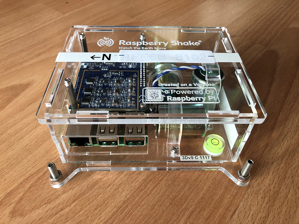
Die Grundlage dieses Projekts bildet das seismo@school Programm, das von der Universität Lausanne und der HES-SO Valais-Wallis in den letzten Jahren initiiert wurde und an dem sich bislang 22 Schulen in den Kantonen Wallis und Waadt beteiligen. Dank eines vom SNF finanzierten zweijährigen AGORA-Projekts mit dem Titel "Förderung des Erdbebenbewusstseins in der Schweiz" werden wir dieses Programm auf die ganze Schweiz ausweiten. In diesem Projekt werden wir in Zusammenarbeit mit dem MINT-Zentrum an der ETH Zürich Unterrichtsmaterialien und Aktivitäten für Sekundarschulen (12-18 Jahre) entwickeln, die es den SchülerInnen ermöglichen, erdbebenrelevante Themen aus der aktuellen Forschung zu erkunden. Zudem werden wir den Schulen einfache seismische Sensoren zur Verfügung stellen, welche es den SchülerInnen erlauben, an ihrer Schule Erdbeben-Seismogramme aufzuzeichnen und auszuwerten. Mit unserem schweizweiten, mehrsprachigen seismo@school-Programm möchten wir zur Aufklärung über Erdbeben, Erdbeben-Gefährdung und -Risiko in der Schweiz und weltweit beitragen, die MINT-Fächer an den Schulen stärken, und nationale und internationale Schulpartnerschaften fördern. |
|---|---|
| SED Projektleiter | Dr. Maren Böse, Dr. Irina Dallo |
| SED Projekt Mitarbeiter/innen | Roman Racine, Urs Fässler, Dr. John Clinton, Nadja Valenzuela, Dr. Michèle Marti, Dr. Florian Haslinger |
| Finanzierung | SNF (Projektnummer 200254) |
| Zeitdauer | 2023-2025 |
| Stichwörter | Erdbebenbewusstsein; Raspberry Shake-Sensoren; Lehrmaterial; explorative Aktivitäten; Schulnetzwerk |
| Bereich | |
| Link zum Projekt Website |
Induzierte Seismizität
GEOBEST2020+
|
As a local, versatile, clean, and renewable energy source, geothermal energy can contribute to achieving Switzerland’s energy and climate objectives. Worldwide, numerous geothermal projects have been successfully operating for decades. Unfortunately, some have also been aborted during the reservoir construction or operation phase. Today, adequate risk governance of induced seismicity is perceived as essential for establishing safe and economically viable geothermal projects. In Switzerland, the subsurface is under the sovereignty of the cantons. Therefore, the cantonal authorities in charge of the permitting, concessioning, and regulatory oversight must have access to independent, state-of-the-art seismological expertise. Furthermore, independent seismic monitoring and competent project oversight are important contributions to risk governance and can build and maintain public acceptance of geothermal projects. GEOBEST2020+ ensures that the Swiss Seismological Service (SED), the federal agency for earthquakes, can provide seismological expertise and baseline seismic monitoring services to the cantons at no cost and independently of the operators of geothermal projects: Seismological consulting:SED experts can support the cantonal authorities with:
Seismic monitoring and earthquake alarming:SED can provide the baseline seismic monitoring, including:
|
|---|---|
| SED Projektleiter | Dr. Toni Kraft |
| SED Projekt Mitarbeiter/innen | Dr. Veronica Antunes, Dr. Philippe Roth, Prof. Dr. Stefan Wiemer |
| Finanzierung | |
| Zeitdauer | from 2020 |
| Stichwörter | Induced Seismicity, Induced Earthquake Hazard & Risk, Real-time monitoring, Support and consultancy |
| Bereich | Induced Seismicity, Induced Earthquake Hazard & Risk, Real-time monitoring, Support and consultancy |
| Link zum Projekt Website |

Erdbebeninduzierte Phänomene
Erdbebenfrühwarnung
Earthquake Early Warning in Central America - Alerta Temprana de Terremotos en América Central (ATTAC)
|
Scientists from the SED are working with local monitoring agencies from the region to build Earthquake Early Warning (EEW) across Central America. This multi-phase project is funded by the Swiss Agency for Development and Cooperation (SDC) at the Federal Department of Foreign Affairs (FDFA). In Phase 1 (2016-2017), SED worked with colleagues at INETER to evaluate the potential for EEW and to implement a prototype EEW system in Nicaragua. In Phase 2 (2018-2021), this prototype system was extended to include monitoring agencies in 3 additional countries - OVSICORI-UNA in Costa Rica, MARN in El Salvador, and INSIVUMEH in Guatemala. 70 EEW-ready strong motion accelerometers were purchased and deployed in the region. We further began to explore how a public EEW could be implemented, with EEW messages being integrated in the the emerging Digital-TV infrastructure as well as with a cellphone app developed within the project. In Phase 3 (2022-2024), we transition to operational EEW and public EEW messages using this cellphone app, and in the case of Guatemala City, an urban siren system. On 14 June 2023, the first public version of the cellphone app was released in Costa Rica. The region suffers from large tsunamigenic earthquakes generated along the subduction zone, and also moderate crustal earthquakes that have in the recent past produced heavy damage, such as the M6.2 1972 earthquake that devastated Managua. The subduction zone events are often characterized by slow rupture velocity (the M7.7 1992 earthquake - the first slow earthquake ever documented - and most recently a M7.3 in 2014) Earthquake Early Warning (EEW) is a tool that can rapidly characterize on-going earthquakes, and potentially provide seconds to 10s of seconds notification of impending strong shaking in advance of its occurrence. EEW can play an important role as part of a seismic risk reduction program, which is critical in the Central American region that has such a high seismic hazard. Additionally, making a seismic network capable of operating and maintaining an EEW system requires the network to achieve the highest standards in network performance - including station quality, speed and reliability of data communications, and robustness of the seismic network hub that runs the EEW software. Optimal network performance is also critical for other applications such as tsunami warning, volcano monitoring, and enables downstream scientific studies, eg on local Earth structure. EEW can work in Central America because the seismic networks are relatively dense and data sharing is well-established and effective - necessary as earthquakes can have impacts beyond a single country. On 9 June 2016, just weeks after the first software was installed and before efforts to optimise had begun, a shallow M6.3 event occurred on the border with El Salvador that was detected by our system after 29s. Though far from the delay time required for operational EEW, this did demonstrate the promise of the existing infrastructure. With the current seismic network and optimised system, we typically can provide first EEW alerts within 8-12s for shallow on-shore earthquakes. This corresponds to a blind zone on the order of 20-30km around the epicenter where no advanced warning will be available. Outside the blind zone, for large earthquakes, this type of EEW can provide warning in advance of the strongest shaking for areas that will experience shaking of intensity VI on the Modified Mercalli Scale. Transfer of EEW capacity from SED to Central American Institutes is feasible because each agency use the same basic software for seismic network monitoring - SeisComP3 - that the SED itself relies on, and on top of which we have added EEW capability. SED use 2 standard algorithms to provide EEW - the Virtual Seismologist and the Finite Fault Detector. We also have been using the EEW Display (EEWD) to deliver desktop alerts to early adopters and testers.
|
|---|---|
| SED Projektleiter | Dr. John Clinton |
| SED Projekt Mitarbeiter/innen | Frédérick Massin, Roman Racine, Maren Böse |
| Finanzierung | Swiss Agency for Development and Cooperation (DEZA / SDC) |
| Zeitdauer | Phase 3: Jan 2022 - March 2024; Phase 2: May 2018 - April 2021 (extension to December 2021); Phase 1: January 2016 - January 2018 |
| Stichwörter | Earthquake Early Warning, Seismic Networks, Nicaragua, Costa Rica, El Salvador, Guatemala, Central America, INETER, DEZA/SDC |
| Bereich | Earthquake Early Warning, Real-time monitoring, Network Seismology |
ShakeAlert (US Westcoast)

|
California, Oregon, and Washington are currently implementing a public earthquake early warning (EEW) system, called ShakeAlert. To detect earthquakes and to generate alerts, ShakeAlert feeds data from the seismic and geodetic networks operated along the US West Coast into two algorithms: the point-source EPIC (formerly known as ElarmS and Onsite), and the finite-source Finite-Fault Rupture Detector (FinDer) algorithm. Alert messages from EPIC and FinDer are aggregated into a single alert feed. ShakeAlert started in 2012 as a demonstration system for EEW and provided warnings of imminent strong ground shaking to a selected group of test users. At that stage, the Virtual Seismologist (VS; Cua and Heaton, 2009), implemented and tested by the SED, was part of the system. In 2013, California passed legislation to implement a public warning system. After the US Congress approved the funding in 2014, the transition to a public system started. A limited public roll-out of ShakeAlert started in California, Oregon, and Washington in the fall of 2018. About one year later the testing of public alerting on mobile devices (phones) was rolled out in California. Washington, and Oregon followed in 2021. Alerts can be received as Wireless Emergency Alerts (WEA) on mobile devices, as well as through apps (e.g. MyShake, QuakeAlertUSA, and ShakeReadySD), or through a ShakeAlert-powered earthquake alert feature that is integrated into the Android Operating System. The SED collaborates with the ShakeAlert team (US Geological Survey, Caltech, UC Berkeley, University of Washington, and University of Oregon) in the development, implementation, and testing of FinDer (Böse et al., 2012; Böse et al., 2015; Böse et al., 2018; Böse et al., 2023). |
|---|---|
| SED Projektleiter | Dr. Maren Böse |
| SED Projekt Mitarbeiter/innen | Dr. Frederick Massin, Dr. Savas Ceylan, Dr. John Clinton |
| Finanzierung | United States Geological Survey (USGS) |
| Zeitdauer | Since 2012 |
| Stichwörter | Earthquake early warning, real-time seismology |
| Bereich | Earthquake Early Warning |
| Link zum Projekt Website | |
| Publikationen |
Böse, M., J. Andrews, R. Hartog, and C. Felizardo (2023). Performance and Next Generation Development of the Finite-Fault Rupture De-tector (FinDer) within the United States West Coast ShakeAlert Warning System. Bull. Seismol. Soc. Am. 113 2, 648-663. doi: 10.1785/0120220183 Chung, A., M. Meier, J. Andrews, M. Böse, B. Crowell, J. McGuire, D. Smith (2020). ShakeAlert Earthquake Early Warning System Performance during the 2019 Ridgecrest Earthquake Sequence. Bull. Seismol. Soc. Am. 110 (4), 1904–1923. doi: 10.1785/0120200032 Böse, M., D.E. Smith, C. Felizardo, M.-A. Meier, T.H. Heaton, J.F. Clinton (2018). FinDer v.2: Improved Real-time Ground-Motion Predictions for M2-M9 with Seismic Finite-Source Characterization. Geophys. J. Int. 212, 725-742. Behr, Y., J. F. Clinton, P. Kästli, C. Cauzzi, and M.-A. Meier (2015). Anatomy of an Earthquake Early Warning (EEW) Alert : Predicting Time Delays for an End-to-End EEW System. Seismol. Res. Lett. 86 (3), 1-11. doi: 10.1785/0220140179 Meier, M.-A., T. Heaton, and J. Clinton (2015). The Gutenberg Algorithm: Evolutionary Bayesian Magnitude Estimates for Earthquake Early Warning with a Filter Bank. Bull. Seismol. Soc. Am. 105 (5), 2774-2786. doi: 10.1785/0120150098 Böse, M., C. Felizardo, & T.H. Heaton (2015). Finite-Fault Rupture Detector (FinDer): Going Real-Time in Californian ShakeAlert Warning System. Seismol. Res. Lett. 86 (6), 1692-1704. Böse, M., R. Graves, D. Gill, S. Callaghan, and P. Maechling (2014). CyberShake-Derived Ground-Motion Prediction Models for the Los Angeles Region with Applica-tion to EEW. Geophys. J. Int. 198 (3), 1438-1457. Given, D.D., Cochran, E.S., Heaton, T., Hauksson, E., Allen, R., Hellweg, P., Vidale, J., and Bodin, P. (2014). Technical implementation plan for the ShakeAlert production system—An Earthquake Early Warning system for the West Coast of the United States. U.S. Geological Survey Open-File Report 2014–1097, 25. doi: 10.3133/ofr20141097 Böse, M., R. Allen, H. Brown, C. Cua, M. Fischer, E. Hauksson, T. Heaton, M. Hellweg, M. Liukis, D. Neu-hauser, P. Maechling, P. and CISN EEW Group (2013). CISN ShakeAlert – An Earthquake Early Warning Demonstration System for California. In: F. Wenzel and J. Zschau: Early Warning for Geological Disasters - Scientific Methods and Current Practice (ISBN: 978-3-642-12232-3). Springer Berlin Heidelberg New York: Böse, M., T.H. Heaton, & E. Hauksson (2012). Real-time Finite Fault Rupture Detector (FinDer) for Large Earthquakes. Geophys. J. Int. 191 (2), 803-812. Böse, M., T. Heaton and E. Hauksson (2012). Rapid estimation of earthquake source and ground-motion parameters for earthquake early warning using data from single three-component broadband or strong-motion sensor. Bull. Seismol. Soc. Am. 102 (2), 738-750. doi: 10.1785/0120110152 Böse, M. & T.H. Heaton (2010). Probabilistic Prediction of Rupture Length, Slip and Seismic Ground Motions for an Ongoing Rupture: implications for Early Warning for Large Earthquakes. Geophys. J. Int. 183 (2), 1014-1030. doi: 10.1111/j.1365-246X.2010.04774.x Cua, G. B., M. Fischer, T. H. Heaton, and S. Wiemer (2009). Real-time Performance of the Virtual Seismologist Earthquake Early Warning Algorithm in Southern California. Seismol. Res. Lett. 80 (5), 740-747. doi: 10.1785/gssrl.80.5.740 |
| Presentationen |
Echtzeitüberwachung
Mont Terri
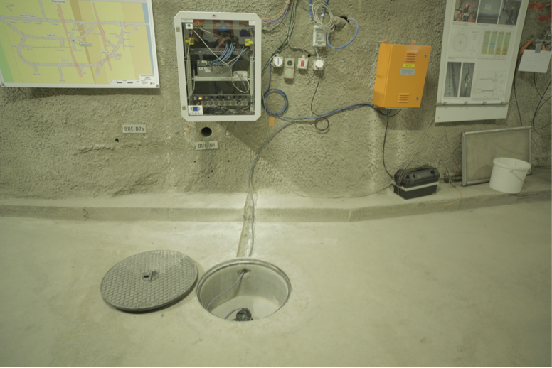
|
SED installed 3 seismological stations in the surroundings of the Mont Terri rock laboratory (St Ursanne, Canton Jura): 2 in the tunnel (stations MTI01 and MTI02) and 1 at the surface (MTI03). The Engineering Seismology group is in charge of the site characterization of these 3 stations. Therefore, a literature review and geophysical experiments are performed in order to propose velocity models able to reproduce the ground motion observed at these stations. |
|---|---|
| SED Projektleiter | Prof. Donat Fäh |
| SED Projekt Mitarbeiter/innen | Valerio Poggi, Clotaire Michel, Sacha Barman, Robin Hansemann |
| Finanzierung | Swisstopo |
| Zeitdauer | 2013-2023 |
| Stichwörter | Earthquake monitoring, Ground motion at depth |
| Bereich |
ArtEmis: Awareness and resilience through European multi sensor system

|
ArtEmis will design, build, and operate a smart and scalable multi sensor system comprising of about 100-200 novel low-cost geochemical sensors, that will measure with unprecedent spatial and temporal resolution changes in radon concentration in ground water, together with other observables like temperature and acidity. |
|---|---|
| SED Projektleiter | Michael Strupler |
| SED Projekt Mitarbeiter/innen | Stefan Wiemer, Michael Strupler (former member) |
| Finanzierung | European Union |
| Zeitdauer | 48 months; project start: 1 October 2022 |
| Stichwörter | Radon, Earthquakes, Sensors, Machine Learning, Awareness |
| Bereich | Real-time monitoring, Earthquake Statistics |
Seismotektonik
Starkbebenseismologie
Ingenieurseismologie
Earthquake Risk Model Basel-Stadt
The project Earthquake Risk Model Basel-Stadt (ERM-BS) 2019 to 2023 aims at developing a site specific seismic hazard and risk framework for the Swiss canton of Basel-Stadt. It is a follow-up of the projects Microzonation (2003 - 2009) and Basel Erdbebenvorsorge (2013 - 2016) funded by the canton of Basel-Stadt in its effort to set an earthquake risk mitigation and crisis management strategy for the canton. This project makes a step forward by attempting to develop a 3D integrated geological-seismological model of Basel, which will explicitly account for the complex geological conditions at the surface and at depth. Ground motion amplification models will be developed and validated with earthquake recordings from the permanent and temporary seismic network in the region. |
|
| SED Projektleiter | Prof. Donat Fäh |
|---|---|
| SED Projekt Mitarbeiter/innen | Afifa Imtiaz, Francesco Panzera |
| Finanzierung | Kanton Basel-Stadt |
| Zeitdauer | 2019-2023 |
| Stichwörter | 3D model, Basel city, ground motion amplification, seismic network, site effects, cantonal building database, seismic vulnerability, seismic risk |
| Bereich | Engineering Seismology, Seismic Hazard & Risk |
ENSI - SED-Erdbebenforschung zu Schweizer Kernanlagen
|
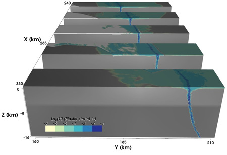
The third phase of this project is split into 3 subtasks with the main goal to improve regional and local seismic hazard assessment in Switzerland; with particular focus to the sites of potential regions of nuclear repositories. These sub-projects are: Subproject 1 aims to improve models and develop methods for the prediction of strong ground motion in Switzerland at the surface and at depth. Two main approaches are investigated: ground motion prediction equations (GMPEs) and stochastic simulation models. Both approaches require calibration to the local seismicity and careful consideration of their extrapolation to large magnitude events which have, as yet, not been instrumentally recorded in Switzerland. In this context, we study the effect of source- and site-related parameters, as stress drop and kappa. Subproject 2 is focused on earthquake scenario modeling for Switzerland and exploration of the physical limits on ground motion. Our modeling combines realistic rupture along irregular fault surfaces and wave propagation in complex heterogeneous media at high frequency, with focus on underground repositories. Moreover we investigate the plastic and non-linear behavior of soft sediments when subject to high-amplitude Mach waves, conducting CPT measurements to calibrate our numerical models. Subproject 3 focuses on numerical modeling the induced seismicity during tunnel excavation. Simulations will be performed using both thermo-hydro-mechanical coupled model and statistical model. We will adapt existing models for induced earthquakes to the conditions typically met in deep geological repositories. Available geomechanical faulting models will be used during the validation and calibration stage. Finally, the results will be used as input for Subproject 1 and 2. |
|---|---|
| SED Projektleiter | Prof. Donat Fäh
|
| SED Projekt Mitarbeiter/innen | Miroslav Hallo, Paolo Bergamo, Antonio Rinaldi |
| Finanzierung | Swiss Federal Nuclear Safety Inspectorate - ENSI |
| Zeitdauer | 2010-2014 (1st phase), 2014-2018 (2nd phase), 2018-2022 (3rd phase), 2022-2026 (4th phase) |
| Stichwörter | Ground motion prediction equations, ground motion modelling, induced seismicity |
| Bereich | Swiss Seismicity, Earthquake Hazard & Risk |
| Berichte / Ergebnisse |
D. Fäh, S. Wiemer, D. Roten, B. Edwards, V. Poggi, C. Cauzzi, J. Burjanek, M. Spada, R. Grolimund, M. Gisler, G. Schwarz-Zanetti, P. Kästli (2012). Expertengruppe Starkbeben. ENSI Erfahrungs- und Forschungsbericht 2011, 173-182. Eidgenösisches Nuklearsicherheitsinspektorat ENSI. PDF D. Fäh, S. Wiemer, B. Edwards, V. Poggi, D. Roten, R. Grolimund, M. Spada, J. Wössner (2013). Expertengruppe Starkbeben. ENSI Erfahrungs- und Forschungsbericht 2012, 173-181. Eidgenösisches Nuklearsicherheitsinspektorat ENSI. PDF D. Fäh, S. Wiemer, B. Edwards, V. Poggi, D. Roten, R. Grolimund, M. Spada, B. Schechinger, J. Woessner (2014). Expertengruppe Starkebeben. ENSI Erfahrungs- und Forschungsbericht 2013, 161-170. Eidgenösisches Nuklearsicherheitsinspektorat ENSI. PDF D. Fäh, S. Wiemer, B. Edwards, V. Poggi, D. Roten, R. Grolimund, M. Spada, B. Schechinger , T. Tormann, J. Woessner (2015). Earthquake Strong Motion Research. ENSI Erfahrungs- und Forschungsbericht 2014, 171-180. Eidgenösisches Nuklearsicherheitsinspektorat ENSI. PDF |
Site Characterization Research
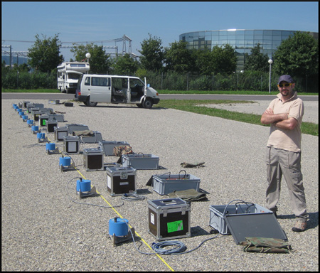
|
This working group gathers the researchers with competences in site characterization in order to discuss and improve the work performed in different projects, especially for sites with new permanent seismic stations. The available tools for processing, archiving and disseminating are shared within the group. The group is responsible for setting up and updating the SED database for site characterization. The group meets regularly to discuss new results and to review the work before it is published. |
|---|---|
| SED Projektleiter | Prof. Donat Fäh |
| SED Projekt Mitarbeiter/innen | Paolo Bergamo, Dario Chieppa, Franziska Glüer, Miroslav Hallo, Mauro Häusler, Afifa Imtiaz, Agostiny Lontsi, Francesco Panzera, Paulina Janusz, Anastasiia Shynkarenko |
| Finanzierung | Actual projects with site characterization work: Strong motion renewal project phase 2; Earthquake risk model for Switzerland; Earthquake risk model for Basel; 4D seismic response and slope failure; Lake Tsunamis: causes, consequences and hazard; and others) |
| Zeitdauer | 2010 - present |
| Stichwörter | Site characterization, strong motion stations, broadband stations, site response, site effects, site amplification |
| Bereich | Earthquake Hazard & Risk, Engineering Seismology |
| Link zum Projekt Website | |
| Publikationen |
Bergamo., P., Hammer, C. and Fäh, D. (2021). Correspondence between Site Amplification and Topographical, Geological Parameters: Collation of Data from Swiss and Japanese Stations, and Neural Networks‐Based Prediction of Local Response. Bulletin of the Seismological Society of America 112 (2). Link doi: 10.1785/0120210225 Michel, C., Fäh, D., Edwards, B., & Cauzzi, C. (2017). Site amplification at the city scale in Basel (Switzerland) from geophysical site characterization and spectral modelling of recorded earthquakes. Physics and Chemistry of the Earth, Parts A/B/C 98, 27-40. doi: 10.1016/j.pce.2016.07.005 Poggi, V., Burjanek, J., Michel, C., & Fäh, D. (2017). Seismic site-response characterization of high-velocity sites using advanced geophysical techniques: application to the NAGRA-Net. Geophysical Journal International 210(2), 645–659. doi: 10.1093/gji/ggx192 Michel, C., Edwards, B., Poggi, V., Burjanek, J., Roten, D., Cauzzi, C. and Fäh, D. (2014). Assessment of site effects in Alpine regions through systematic site characterization of seismic stations. Bulletin of the Seismological Society of America 104(6), 2809-2826. doi: 10.1785/0120140097 Burjánek, J., Edwards, B. and Fäh, D. (2014). Empirical evidence of local seismic effects at sites with pronounced topography: a systematic approach. Geophysical Journal International 197(1), 608-619. doi: 10.1093/gji/ggu014 Edwards, B., Michel, C., Poggi, V. and Fäh D. (2013). Determination of Site Amplification from Regional Seismicity: Application to the Swiss National Seismic Networks. Seismological Research Letters 84(4), 611-621. doi: 10.1785/0220120176 Hobiger, M., Bergamo, P., Imperatori, W., Panzera, F., Lontsi, M.S., Perron, V., Michel, C., Burjánek, J., Fäh, D. (2021). Site Characterization of Swiss Strong‐Motion Stations: The Benefit of Advanced Processing Algorithms. Bulletin of the Seismological Society of America 111 (4), 1713-1739. Link doi: 10.1785/0120200316 Panzera, F., Alber, J., Imperatori, W., Bergamo, P., Fäh, D. (2022). Reconstructing a 3D model from geophysical data for local amplification modelling: The study case of the upper Rhone valley, Switzerland.. Soil Dynamics and Earthquake Engineering 155. Link doi: 10.1016/j.soildyn.2022.107163 Glueer, F., Häusler, M., Gischig, V., Fäh, D. (2021). Coseismic Stability Assessment of a Damaged Underground Ammunition Storage Chamber Through Ambient Vibration Recordings and Numerical Modelling. Frontiers of Earth Science 9 (1159), 773155. Link doi: 10.3389/feart.2021.773155 Shynkarenko, A., Lontsi, A.M., Kremer, K., Bergamo, P., Hobiger, M., Hallo, M., Fäh D. (2021). Investigating the subsurface in a shallow water environment using array and single-station ambient vibration techniques. Geophysical Journal International 227 (3), 1857-1878. Link doi: 10.1093/gji/ggab314 Lontsi, A.M., Shynkarenko, A., Kremer, K., Hobiger, M., Bergamo, P., Fabbri, S.C., Anselmetti, F.S. and Fäh, D. (2021). A robust workflow for acquiring and preprocessing ambient vibration data from small aperture ocean bottom seismometer arrays to extract Scholte and Love waves phase-velocity dispersion curves. Pure and Applied Geophysics. Link doi: 10.1007/s00024-021-02923-8 Häusler, M., Michel, C., Burjánek, J., and Fäh, D. (2021). Monitoring the Preonzo rock slope instability using resonance mode analysis. J. Geophys. Res. Earth Surf. e2020JF005709. Link doi: 10.1029/2020JF005709 Hallo, M., Imperatori, W., Panzera, F., Fäh, D. (2021). Joint multizonal transdimensional Bayesian inversion of surface wave dispersion and ellipticity curves for local near-surface imaging. Geophysical Journal International 226 (1), 627-659. doi: https://doi.org/10.1093/gji/ggab116 Bergamo, P., Hammer, C., and Fäh, D. (2021). On the Relation between Empirical Amplification and Proxies Measured at Swiss and Japanese Stations: Systematic Regression Analysis and Neural Network Prediction of Amplification. Bulletin of the Seismological Society of America 111 (1), 101-120. Link doi: 10.1785/0120200228 Chieppa, D., Hobiger, M.& D. Fäh (2020). Ambient Vibration Analysis on Large Scale Arrays When Lateral Variations Occur in the Subsurface: A Study Case in Switzerland. Pure and Applied Geophysics 177, 4247–4269. Link doi: 10.1007/s00024-020-02516-x Chieppa, D., Hobiger, M. & D. Fäh (2020). Ambient vibration analysis on seismic arrays to investigate the properties of the upper crust: an example from Herdern in Switzerland. Geophysical Journal International ggaa182. doi: 10.1093/gji/ggaa182 Häusler, M Michel, C. Burjanek, J. & D. Fäh (2019). Fracture Network Imaging on Rock Slope Instabilities Using Resonance Mode Analysis. Geophysical Research Letters Volume 46, Issue 12, 6497-6506. doi: 10.1029/2019GL083201 Kleinbrod, U., Burjanek, J., Fäh, D (2019). Ambient vibration classification of unstable rock slopes: A systematic approach. Engineering Geology Volume 249, 198-217. Maranò, S., Hobiger, M., Bergamo, P. & D. Fäh (2017). Analysis of Rayleigh waves with circular wavefront: a maximum likelihood approach. Geophysical Journal International 210, 3, 1570–1580. doi: https://doi.org/10.1093/gji/ggx225 Burjánek, J., Gischig, V., Moore, J.R. and Fäh, D. (2018). Ambient vibration characterization and monitoring of a rock slope close to collapse. Geophys. J. Int. 212, 297–310. Link doi: 10.1093/gji/ggx424 Maranò, S., Hobiger, M. & D. Fäh (2017). Retrieval of Rayleigh Wave Ellipticity from Ambient Vibration Recordings. Geophys. J. Int.. Link doi: 10.1093/gji/ggx014 Kleinbrod, U., Burjánek, J., Fäh, D. (2017). On the seismic response of instable rock slopes based on ambient vibration recordings. Earth. Planets and Space 69: 126. doi: 10.1186/s40623-017-0712-5 Kleinbrod, U., Huggentobler, M., Burjánek, J., Aman, F., Fäh, D. (2017). A comparative study on seismic response of two unstable rock slopes within same tectonic setting but different activity level. Geophys. J. Int. 211, 3, 1428-1448. Link doi: 10.1093/gji/ggx376 Panzera, F., Bergamo, P. & Fäh, D. (2020). Reference soil condition for intensity prediction equations derived from seismological and geophysical data at seismic stations. Journal of Seismology 25 (1). Link doi: 10.1007/s10950-020-09962-z |
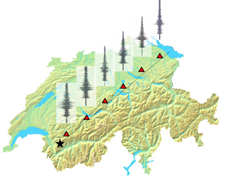
Erarbeitung von elastischen Antwortspektren für Alpentäler als Grundlage für eine Weiterentwicklung der Baunorm SIA 261
|
|
Siedlungen, die nur wenige hundert Meter voneinander entfernt sind, können von ein und demselben Erdbeben in sehr unterschiedlichem Maße betroffen sein. Die Ursache dafür ist die lokale Standortverstärkung, die von der Art des Bodens (z. B. weiche Sedimente oder steifer Fels), aber auch von seiner Geometrie (eine weite Ebene oder ein Sedimentbecken) bestimmt wird. In dieser Hinsicht sind die Alpentäler ein besonderes geologisches Umfeld, da die Mächtigkeit der Sedimentfüllung von wenigen Metern an den Talrändern bis zu mehreren hundert Metern in der Mitte des Tals ansteigt. Dieser Umstand führt zu besonderen Auswirkungen bei Erdbeben. Außerdem sind Täler unter Risikogesichtspunkten nicht unbedeutend, da sie dicht besiedelt sein können und wichtige Infrastrukturen für den Transport von Gütern und Personen über die Alpen beherbergen. |
|---|---|
| SED Projektleiter | Donat Fäh |
| SED Projekt Mitarbeiter/innen | Paolo Bergamo, Dario Chieppa |
| Finanzierung | BAFU (Bundesamt für Umwelt) |
| Zeitdauer | 2021 - 2024 |
| Stichwörter | Standorteinfluss bei Erdbeben, Alpine Täler, Gebäudenormen |
| Bereich | Ingenieurseismologie |
| Publikationen |
Arbeitsgruppe Erdbeben der Normenkommission SIA 261 (2019). Aktualisierung der Erdbebeneinwirkungen der Norm SIA 261:2014 . Bericht z.H. der Normkommission SIA 261 und der Kommission für technische Normen (KTN) Referenz/Aktenzeichen: S041-0132. In: Bundesamt für Umwelt BAFU Abteilung Gefahrenprävention, 26.03.2019. BAFU (2020). Erdbebenrisikomanagement - Massnahmen des Bundes. Bericht an den Bundesrat. Standbericht und Planung für den Zeitraum 2021 bis 2024. Bundesamt für Umwelt, Dezember 2020. |
Numerische Modellierung
Ground Motion Prediction Equations (GMPEs)
|
This is the 1st subproject of the “ENSI – SED-Erdbebenforschung zu Schweizer Kernanlagen” project. This subproject aims to improve source-scaling and attenuation models and to develop methods for the prediction of strong ground motion in Switzerland both at the surface as well as at depth. Two main approaches are investigated: ground motion prediction equations (GMPEs) and stochastic simulation models. Both approaches require adaptions to the local seismicity and careful consideration of their calibration to Swiss conditions. The Fourier spectral and stochastic models correspond to the current state of research and have some advantages over the empirical attenuation relationships, as it is possible to adjust the model to specific local site conditions. The complete understanding in terms of physical parameterization of such models is crucial in order to decouple different effects, which allow building robust predictive models that scale appropriately to large magnitude events. In this regard, variability in source parameter such as stress drop and corner frequency is crucial. Similarly, variability in site-related attenuation parameter kappa (local intrinsic and scattering attenuation) is also need to be well understood. Developed stochastic and duration models from Japanese data allow the review of the Swiss model for large magnitudes in the different distance ranges and at various rock sites which have, as yet, not been instrumentally recorded in Switzerland. The local weak-to-moderate seismicity is used to calibrate the predictive models. The long-term goal is to develop an improved stochastic simulation model for Switzerland allowing existing uncertainties to be rigorously evaluated and reduced. In future, such models will also allow an assessment of ground motion caused by induced seismicity due to the activation of existing fractures and/or the generation of new fractures. Moreover, we developed, validated, and applied a physics-based stochastic model to characterize high-frequency ground motion at depth in the Fourier domain. The goal of it is to be able to predict future ground motions at deep geological disposals. |
|---|---|
| SED Projektleiter | Prof. Donat Fäh |
| SED Projekt Mitarbeiter/innen | Miroslav Hallo, Paolo Bergamo |
| Finanzierung | Swiss Federal Nuclear Safety Inspectorate - ENSI |
| Zeitdauer | 2014-2026 |
| Stichwörter | Ground motion prediction equations, Fourier spectral models, stochastic ground motion models, ground motion duration models. |
| Bereich | Earthquake Hazard & Risk, Engineering Seismology |
| Publikationen |
Hallo, M., Bergamo, P., and Fäh, D. (2022). Stochastic model to characterize high-frequency ground motion at depth validated by KiK-net vertical array data. Bulletin of the Seismological Society of America (under review).. Bard, P.-Y., Bora, S. S., Hollender, F., Laurendeau, A., and Traversa, P. (2020). Are the standard VS-Kappa host-to-harget adjustments the only way to get consistent hard-rock ground motion prediction?. Pure and Applied Geophysics 177, 2049–2068. doi: 10.1007/s00024-019-02173-9 Edwards, B., and Fäh, D. (2017). Prediction of earthquake ground motion at rock sites in Japan: evaluation of empirical and stochastic approaches for the PEGASOS Refinement Project. Geophysical Journal International 211(2), 766-783. doi: 10.1093/gji/ggx328 Pilz, M., and Fäh, D. (2017). The contribution of scattering to near-surface attenuation. Journal of Seismology 21 (4), 837–855. doi: 10.1007/s10950-017-9638-4 Edwards, B., Cauzzi, C., Danciu, L., and Fäh, D. (2016). Region-specific assessment, adjustment, and weighting of ground-motion prediction models: Application to the 2015 Swiss seismic-hazard maps. Bulletin of the Seismological Society of America 106 (4), 1840-1857. doi: 10.1785/0120150367 Edwards, B., Ktenidou, O.-J., Cotton, F., Abrahamson, N., Van Houtte, C. and Fäh, D. (2015). Epistemic uncertainty and limitations of the Kappa0 model for near-surface attenuation at hard rock sites. Geophysical Journal International 202 (3), 1627-1645. doi: 10.1093/gji/ggv222 Edwards, B. & Fäh, D. (2014). Ground motion prediction equations. Link doi: 10.3929/ethz-a-010232326 Edwards, B. and Fäh D. (2013). A Stochastic Ground‐Motion Model for Switzerland. Bulletin of the Seismological Society of America 103, 78-98. doi: 10.1785/0120110331 Edwards, B., Michel, C., Poggi, V. and Fäh, D. (2013). Determination of Site Amplification from Regional Seismicity: Application to the Swiss National Seismic Networks. Seism. Res. Lett. 84(4), 611-621. doi: 10.1785/0220120176 Poggi, V., Edwards, B. and Fäh, D (2013). Reference S-wave velocity profile and attenuation models for ground-motion prediction equations: application to Japan. Bulletin of the Seismological Society of America 103(5), 2645-2656. doi: 10.1785/0120120362 Poggi, V., Edwards, B. and Fäh, D. (2012). Characterizing the vertical to horizontal ratio of ground-motion at soft sediment sites. Bulletin of the Seismological Society of America 102(6), 2741-2756. doi: 10.1785/0120120039 Poggi, V., Edwards, B. and Fäh, D. (2011). Derivation of a Reference Shear-Wave Velocity Model from Empirical Site Amplification. Bulletin of the Seismological Society of America 101(1), 258-274. doi: 10.1785/0120100060 |