Drücken Sie die Tabulatortaste um den Bildschirmleser Modus zu aktivieren
  • Startseite
  • Sprache
  • Navigationsmenu
  • Suche
  • Leichte Sprache
  • Inhalt
  • Kontakt
MENU
Logo Schweizerischer Erdbebendienst ETH logo
DE EN FR IT
Leichte Sprache
DE EN FR IT
×
  • Startseite
  • Erdbeben
    • Schweiz
    • Europa
    • Welt
    • Karten
    • Melden Sie ein Erdbeben
    • Was tun?
      • Verhaltensempfehlungen
      • Erdbeben im Ausland
      • Erdbebengerechtes Bauen
      • Erdbebenversicherung
    • Jederzeit informiert
      • Alarmierung
      • Informationen erhalten
      • Schnelle Schadensabschätzungen
      • ShakeMap
      • Erdbebenmeldungen
  • Überwachung
    • Erdbeben messen
    • Nationales seismisches Netzwerk
    • Spezialnetzwerke
      • Übersicht
      • Geothermie Haute-Sorne
      • Geothermie Yverdon-les-Bains
      • Geothermie Genfer Becken
      • Geothermie Vinzel
      • Tiefenlager Nordostschweiz
      • Überwachung Tiefenbohrung Basel-1
      • Vergangene Projekte
    • Echtzeit-Seismogramme
      • Letzte 5 Minuten
      • Letzte 20 Minuten
      • Letzte 2 Stunden
      • Letzte 24 Stunden
    • Aufbau einer Messstation
    • Atomteststoppüberwachung
  • Erdbebenland Schweiz
    • Übersicht
    • Gefährdung
      • Übersicht
      • Komponenten
      • Erdbebengefährdungsmodell
    • Risiko
      • Übersicht
      • Komponenten
      • Erdbebenrisikomodell
      • Erdbebenrisikotool
    • Erdbebenszenarien
    • Erdbebenregionen
      • Graubünden
      • Wallis
      • Basel
    • Historische Erdbeben
      • Die zehn stärksten
      • Basel 1356
      • Sierre 1946
    • Erdbebenschwärme
      • Einleitung
      • Sarnen 1964
      • Diemtigen 2014 - 2015
  • Wissen
    • Ursachen von Erdbeben
      • Im Allgemeinen
      • In der Schweiz
      • In Europa
      • Induzierte Erdbeben
    • Auswirkungen von Erdbeben
    • Erdbebenvorhersage
    • Erdbebendaten und Webportale
      • Übersicht
      • Erdbebenüberwachungs-Software
      • Stationsinformationen
      • Erdbebenkataloge
      • Wellenformdaten
      • FDSN web services
      • Erdbebenfrühwarnung
      • ShakeMap
      • Ältere Softwares
    • Geothermie & Erdbeben
      • Geothermie in Kürze
      • Formen der Geothermie
      • Geothermie & induzierte Erdbeben
      • Massnahmen zur Eindämmung induzierter Seismizität
      • Geothermie in der Schweiz
      • Geothermie und der SED
      • Kompetente seismologische Beratung (GEOBEST2020+)
      • Fracking
    • Beben auf dem Mars
    • Häufig gestellte Fragen (FAQ)
  • Forschung & Lehre
    • Projekte
    • Publikationen
    • Lehre & Ausbildung
    • Schatzalp Workshop 2025
  • Aktuelles & Angebote
    • Aktuellbeiträge
      • 2025
      • 2024
      • Archiv
    • Für Schulen
    • Informationsbroschüren
    • Quiz
    • Videos & Spiele
    • Erdbebensimulator
    • Erdbebenliteratur
  • Über uns
    • Kontakt & Medienanfragen
    • Porträt
      • Aufgaben & Organisation
      • Geschichte
      • Unabhängigkeit & Transparenz
    • Sektionen
    • Alle Mitarbeitenden
    • Karriere
    • Kooperationen
    • Intranet
Der Seiteninhalt beginnt hier

Lake sediments as archive of paleoearthquakes in Switzerland
  • Übersicht
Projektbild

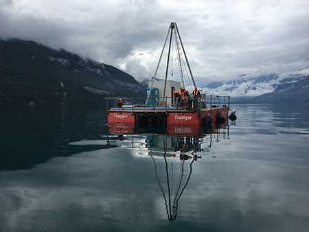
Earthquake can initiate subaquatic mass transport and sediment deformation structures, the deposits of which are stored in the sedimentary archive. Due to their good preservation potential and improving dating methods, these earthquake-related deposits in the sedimentary archive of lakes can extend the earthquake catalogue back to prehistorical times. The determination of frequency, epicentre and magnitude of these paleoearthquakes can be a key input for improving a probabilistic seismic hazard model, especially in areas such as Switzerland where strong earthquakes have long recurrence rates and might not be recorded in historic times. In order to better interpret the prehistorical earthquake-related sedimentary record, it remains important to understand which historical earthquakes did trigger mass transport deposits and sediment deformation structures, and which earthquakes did not trigger secondary sedimentary effects in the lake basins.

The proposed project is aimed to improve our understanding of which earthquakes, or what kind of shaking, leave traces in the sediments, in order to evaluate the completeness of the sublacustrine paleoseismological record, using Lake Thun as example. The second aim of this project, directly linked to the first one, is to compare the paleoseismological record with the contemporary national seismic hazard model of Switzerland, updated in 2015. Thus, using the intensity ranges determined in the first part of this project and using the paleoseismic database of Switzerland a systematic analysis of frequencies, sources and magnitudes of possible paleoearthquakes will be compared to time series produced by the seismic hazard model of Switzerland.

SED Projektleitung

Dr. Katrina Kremer

Finanzierung

SNF, Marie Heim-Vögtlin programme

Zeitdauer

2.2017-1.2019

Stichwörter

Lake sediments, paleoseismology, sublacustrine slope failure

Bereich

Historical Seismicity, Paleoseismology

Webseite https://tsunami.ethz.ch

Schweizerischer Erdbebendienst
Sonneggstrasse 5
CH-8092 Zürich
Tel. SED Sekretariat
+41 44 633 21 79 (zu Bürozeiten)

Impressum | Disclaimer  | ©2024 ETH Zürich