Drücken Sie die Tabulatortaste um den Bildschirmleser Modus zu aktivieren
  • Startseite
  • Sprache
  • Navigationsmenu
  • Suche
  • Leichte Sprache
  • Inhalt
  • Kontakt
MENU
Logo Schweizerischer Erdbebendienst ETH logo
DE EN FR IT
Leichte Sprache
DE EN FR IT
×
  • Startseite
  • Erdbeben
    • Schweiz
    • Europa
    • Welt
    • Karten
    • Melden Sie ein Erdbeben
    • Was tun?
      • Verhaltensempfehlungen
      • Erdbeben im Ausland
      • Erdbebengerechtes Bauen
      • Erdbebenversicherung
    • Jederzeit informiert
      • Alarmierung
      • Informationen erhalten
      • Schnelle Schadensabschätzungen
      • ShakeMap
      • Erdbebenmeldungen
  • Überwachung
    • Erdbeben messen
    • Nationales seismisches Netzwerk
    • Spezialnetzwerke
      • Übersicht
      • Geothermie Haute-Sorne
      • Geothermie Yverdon-les-Bains
      • Geothermie Genfer Becken
      • Geothermie Vinzel
      • Tiefenlager Nordostschweiz
      • Überwachung Tiefenbohrung Basel-1
      • Vergangene Projekte
    • Echtzeit-Seismogramme
      • Letzte 5 Minuten
      • Letzte 20 Minuten
      • Letzte 2 Stunden
      • Letzte 24 Stunden
    • Aufbau einer Messstation
    • Atomteststoppüberwachung
  • Erdbebenland Schweiz
    • Übersicht
    • Gefährdung
      • Übersicht
      • Komponenten
      • Erdbebengefährdungsmodell
    • Risiko
      • Übersicht
      • Komponenten
      • Erdbebenrisikomodell
      • Erdbebenrisikotool
    • Erdbebenszenarien
    • Erdbebenregionen
      • Graubünden
      • Wallis
      • Basel
    • Historische Erdbeben
      • Die zehn stärksten
      • Basel 1356
      • Sierre 1946
    • Erdbebenschwärme
      • Einleitung
      • Sarnen 1964
      • Diemtigen 2014 - 2015
  • Wissen
    • Ursachen von Erdbeben
      • Im Allgemeinen
      • In der Schweiz
      • In Europa
      • Induzierte Erdbeben
    • Auswirkungen von Erdbeben
    • Erdbebenvorhersage
    • Erdbebendaten und Webportale
      • Übersicht
      • Erdbebenüberwachungs-Software
      • Stationsinformationen
      • Erdbebenkataloge
      • Wellenformdaten
      • FDSN web services
      • Erdbebenfrühwarnung
      • ShakeMap
      • Ältere Softwares
    • Geothermie & Erdbeben
      • Geothermie in Kürze
      • Formen der Geothermie
      • Geothermie & induzierte Erdbeben
      • Massnahmen zur Eindämmung induzierter Seismizität
      • Geothermie in der Schweiz
      • Geothermie und der SED
      • Kompetente seismologische Beratung (GEOBEST2020+)
      • Fracking
    • Beben auf dem Mars
    • Häufig gestellte Fragen (FAQ)
  • Forschung & Lehre
    • Projekte
    • Publikationen
    • Lehre & Ausbildung
    • Schatzalp Workshop 2025
  • Aktuelles & Angebote
    • Aktuellbeiträge
      • 2025
      • 2024
      • Archiv
    • Für Schulen
    • Informationsbroschüren
    • Quiz
    • Videos & Spiele
    • Erdbebensimulator
    • Erdbebenliteratur
  • Über uns
    • Kontakt & Medienanfragen
    • Porträt
      • Aufgaben & Organisation
      • Geschichte
      • Unabhängigkeit & Transparenz
    • Sektionen
    • Alle Mitarbeitenden
    • Karriere
    • Kooperationen
    • Intranet
Der Seiteninhalt beginnt hier

Detection, characterization and monitoring of instabilities with seismic technologies

  • Übersicht
  • Publications
Projektbild

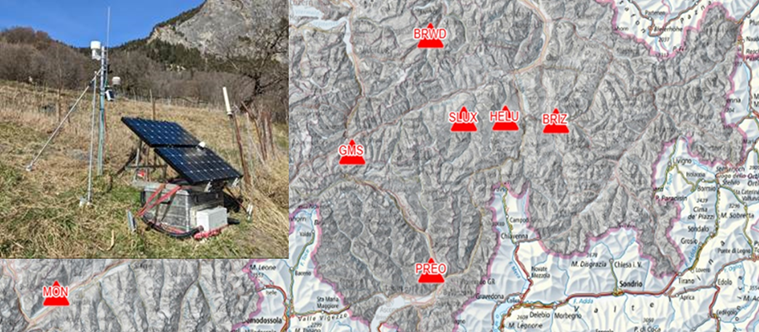
In recent years, we have developed efficient geophysical and seismological measurement tools that enable the characterization of instabilities based on their vibrational behavior and are suitable for monitoring. New methods for the characterization of rock instabilities in terms of extent, volume, and condition, have been developed along with a derived classification and corresponding measurement strategies. Additionally, continuous long-term observations with seismometers have been developed. In the future, such tools will increasingly contribute to quantifying the risks of spontaneous and earthquake-induced instability failures and complement conventional techniques.


Currently, real-time monitoring of instabilities is the only way to provide continuous information for risk assessment and early warning before an event occurs. With seismic monitoring, we are able to monitor the internal properties (stiffness, vibration behavior, amplification, damping, vibration polarization) of the instability with a very high precision. This new component could become standard practice due to its high sensitivity to changes in slope characteristics. The combination of our monitoring, seismic site characterization, integration of deformation measurements and environmental data, and numerical modeling will provide insights into the driving factors of slope failure, and contribute to hazard and risk assessment of unstable slopes.


The aim of this applied project is the national implementation of the developed methods. The work includes the practical continuation of existing measurement sites in order to apply the methods in practice. Our contribution will show how vibration measurements can be used in the future to quickly characterize potential slope instabilities in terms of extent, volume and condition, and how the interpretation can contribute to the optimal placement of measuring systems (seismic, GNSS, total station, etc.).

SED Projektleitung

Prof. Donat Fäh

SED Projekt Mitglieder

Franziska Glüer, Mauro Häusler, Xavier Borgeat

Finanzierung

Bundesamt für Umwelt 00.5032.PZ/ EC049A5A7

Zeitdauer

2023-2025

Stichwörter

Earthquake induced mass movements, unstable rock-slopes, real-time monitoring, seismic methods

Bereich

Earthquake Hazard and Risk, Geo Risks

Borgeat, X., Glueer, F., Häusler, M., Hobiger M. and D. Fäh (2024). On the variability of the seismic response of the active rock slope in Brienz/Brinzauls (Switzerland). Planned for submission to Geophysical Journal International. 

Burjánek, J., Gischig, V., Moore, J.R. and Fäh, D. (2018). Ambient vibration characterization and monitoring of a rock slope close to collapse. Geophys. J. Int. 212, 297-310. https://academic.oup.com/gji/article/212/1/297/4331640

Burjanek, J., Kleinbrod, U., & Fäh, D. (2019). Modeling the Seismic Response of Unstable Rock Mass With Deep Compliant Fractures. Journal of Geophysical Research-Solid Earth 124)12), 13039-13059. doi: 10.1029/2019JB018607

Cauzzi, C., Fäh, D., Wald, D.J., Clinton, J., Losey, S. and S. Wiemer (2018). ShakeMap-based prediction of earthquake-induced mass movements in Switzerland calibrated on historical observations. Natural Hazards 92 (2), 1211-1235. 

Glueer, F., Häusler, M., Gischig, V. and Fäh, D. (2021). Coseismic Stability Assessment of a Damaged Underground Ammunition Storage Chamber Through Ambient Vibration Recordings and Numerical Modelling. Front. Earth Sci. doi: 10.3389/feart.2021.773155

Glueer, F., Mreyen, A.-S., Cauchie, L., Havenith, H.-B., Bergamo, P., Halló, M., & Fäh, D. (2024). Integrating Seismic Methods for Characterizing and Monitoring Landslides: A Case Study of the Heinzenberg Deep-Seated Gravitational Slope Deformation (Switzerland). Geosciences 14 (2), 28. doi: 10.3390/geosciences14020028

Häusler, M., Michel, C., Burjanek, J., & Fäh, D.  (2019). Fracture Network Imaging on Rock Slope Instabilities Using Resonance Mode Analysis. Geophysical Research Letters 46 (12), 6497-6506. doi: 10.1029/2019gl083201

Häusler, M., Glueer, F., Burjánek, J., & Fäh, D.  (2020). Chasing a hidden fracture using seismic refraction tomography: case study Preonzo, Switzerland. EGU2020-9701. In: Paper presented at the EGU General Assembly. doi: 10.5194/egusphere-egu2020-9701

Häusler, M., Michel, C., Burjánek, J., and Fäh, D. (2021). Monitoring the Preonzo rock slope instability using resonance mode analysis. J. Geophys. Res. Earth Surf. doi: 10.1029/2020JF005709

Häusler, M., Gischig, V., Thöny, R., Glueer, F. and Fäh, D. (2021). Monitoring the changing seismic site response of a fast-moving rockslide (Brienz/Brinzauls, Switzerland). Geophysical Journal International 229 (1), 299-310. doi: 10.1093/gji/ggab473

Häusler, M., Glueer, F., & Fäh, D.  (2024). The changing seismic site response of the Brienz/Brinzauls rock slope instability: insights from 5 years of monitoring before, during and after a partial collapse in June 2023. ICL open access book series “Progress in Landslide Research and Technology”, 2-12. 

Kleinbrod, U., Burjánek, J., Fäh, D. (2017). On the seismic response of instable rock slopes based on ambient vibration recordings. Earth. Planets and Space. doi: 10.1186/s40623-017-0712-5

Kleinbrod, U., Huggentobler, M., Burjánek, J., Aman, F., Fäh, D. (2017). A comparative study on seismic response of two unstable rock slopes within same tectonic setting but different activity level. Geophys. J. Int 211 (3), 1428-1448. doi: 10.1093/gji/ggx376

Kleinbrod, U., Burjanek, J., & Fah, D. (2019). Ambient vibration classification of unstable rock slopes: A systematic approach. Engineering Geology 249, 198-217. doi: 10.1016/j.enggeo.2018.12.012

Oprsal, I., Thun, J., Burjánek, J. and D. Fäh (2020). Measurements and modeling of the post-failure micro-deformations and tilts of the Preonzo unstable slope, Alpe di Roscioro, Switzerland. Engineering Geology. doi: 10.1016/j.enggeo.2020.105919

Weber, S., Fäh, D. Beutel., J., Faillettaz, J., Gruber, S., Vieli, A. (2018). Ambient seismic vibrations in steep bedrock permafrost used to infer variations of ice-fill in fractures. Earth and Planetary Science Letters, 119-127. doi: 10.1016/j.epsl.2018.08.042

Weber, S., Beutel, J., Häusler, M., Geimer, P.R., Fäh, D. and Moore, J.R (2021). Spectral amplification of ground motion linked to resonance of large-scale mountain landforms. Earth and Planetary Science Letters. doi: 10.1016/j.epsl.2021.117295
Schweizerischer Erdbebendienst
Sonneggstrasse 5
CH-8092 Zürich
Tel. SED Sekretariat
+41 44 633 21 79 (zu Bürozeiten)

Impressum | Disclaimer  | ©2024 ETH Zürich