Drücken Sie die Tabulatortaste um den Bildschirmleser Modus zu aktivieren
  • Startseite
  • Sprache
  • Navigationsmenu
  • Suche
  • Leichte Sprache
  • Inhalt
  • Kontakt
MENU
Logo Schweizerischer Erdbebendienst ETH logo
DE EN FR IT
Leichte Sprache
DE EN FR IT
×
  • Startseite
  • Erdbeben
    • Schweiz
    • Europa
    • Welt
    • Karten
    • Melden Sie ein Erdbeben
    • Was tun?
      • Verhaltensempfehlungen
      • Erdbeben im Ausland
      • Erdbebengerechtes Bauen
      • Erdbebenversicherung
    • Jederzeit informiert
      • Alarmierung
      • Informationen erhalten
      • Schnelle Schadensabschätzungen
      • ShakeMap
      • Erdbebenmeldungen
  • Überwachung
    • Erdbeben messen
    • Nationales seismisches Netzwerk
    • Spezialnetzwerke
      • Übersicht
      • Geothermie Haute-Sorne
      • Geothermie Yverdon-les-Bains
      • Geothermie Genfer Becken
      • Geothermie Vinzel
      • Tiefenlager Nordostschweiz
      • Überwachung Tiefenbohrung Basel-1
      • Vergangene Projekte
    • Echtzeit-Seismogramme
      • Letzte 5 Minuten
      • Letzte 20 Minuten
      • Letzte 2 Stunden
      • Letzte 24 Stunden
    • Aufbau einer Messstation
    • Atomteststoppüberwachung
  • Erdbebenland Schweiz
    • Übersicht
    • Gefährdung
      • Übersicht
      • Komponenten
      • Erdbebengefährdungsmodell
    • Risiko
      • Übersicht
      • Komponenten
      • Erdbebenrisikomodell
      • Erdbebenrisikotool
    • Erdbebenszenarien
    • Erdbebenregionen
      • Graubünden
      • Wallis
      • Basel
    • Historische Erdbeben
      • Die zehn stärksten
      • Basel 1356
      • Sierre 1946
    • Erdbebenschwärme
      • Einleitung
      • Sarnen 1964
      • Diemtigen 2014 - 2015
  • Wissen
    • Ursachen von Erdbeben
      • Im Allgemeinen
      • In der Schweiz
      • In Europa
      • Induzierte Erdbeben
    • Auswirkungen von Erdbeben
    • Erdbebenvorhersage
    • Erdbebendaten und Webportale
      • Übersicht
      • Erdbebenüberwachungs-Software
      • Stationsinformationen
      • Erdbebenkataloge
      • Wellenformdaten
      • FDSN web services
      • Erdbebenfrühwarnung
      • ShakeMap
      • Ältere Softwares
    • Geothermie & Erdbeben
      • Geothermie in Kürze
      • Formen der Geothermie
      • Geothermie & induzierte Erdbeben
      • Massnahmen zur Eindämmung induzierter Seismizität
      • Geothermie in der Schweiz
      • Geothermie und der SED
      • Kompetente seismologische Beratung (GEOBEST2020+)
      • Fracking
    • Beben auf dem Mars
    • Häufig gestellte Fragen (FAQ)
  • Forschung & Lehre
    • Projekte
    • Publikationen
    • Lehre & Ausbildung
    • Schatzalp Workshop 2025
  • Aktuelles & Angebote
    • Aktuellbeiträge
      • 2025
      • 2024
      • Archiv
    • Für Schulen
    • Informationsbroschüren
    • Quiz
    • Videos & Spiele
    • Erdbebensimulator
    • Erdbebenliteratur
  • Über uns
    • Kontakt & Medienanfragen
    • Porträt
      • Aufgaben & Organisation
      • Geschichte
      • Unabhängigkeit & Transparenz
    • Sektionen
    • Alle Mitarbeitenden
    • Karriere
    • Kooperationen
    • Intranet
Der Seiteninhalt beginnt hier

GeoTwins

  • Übersicht
Projektbild

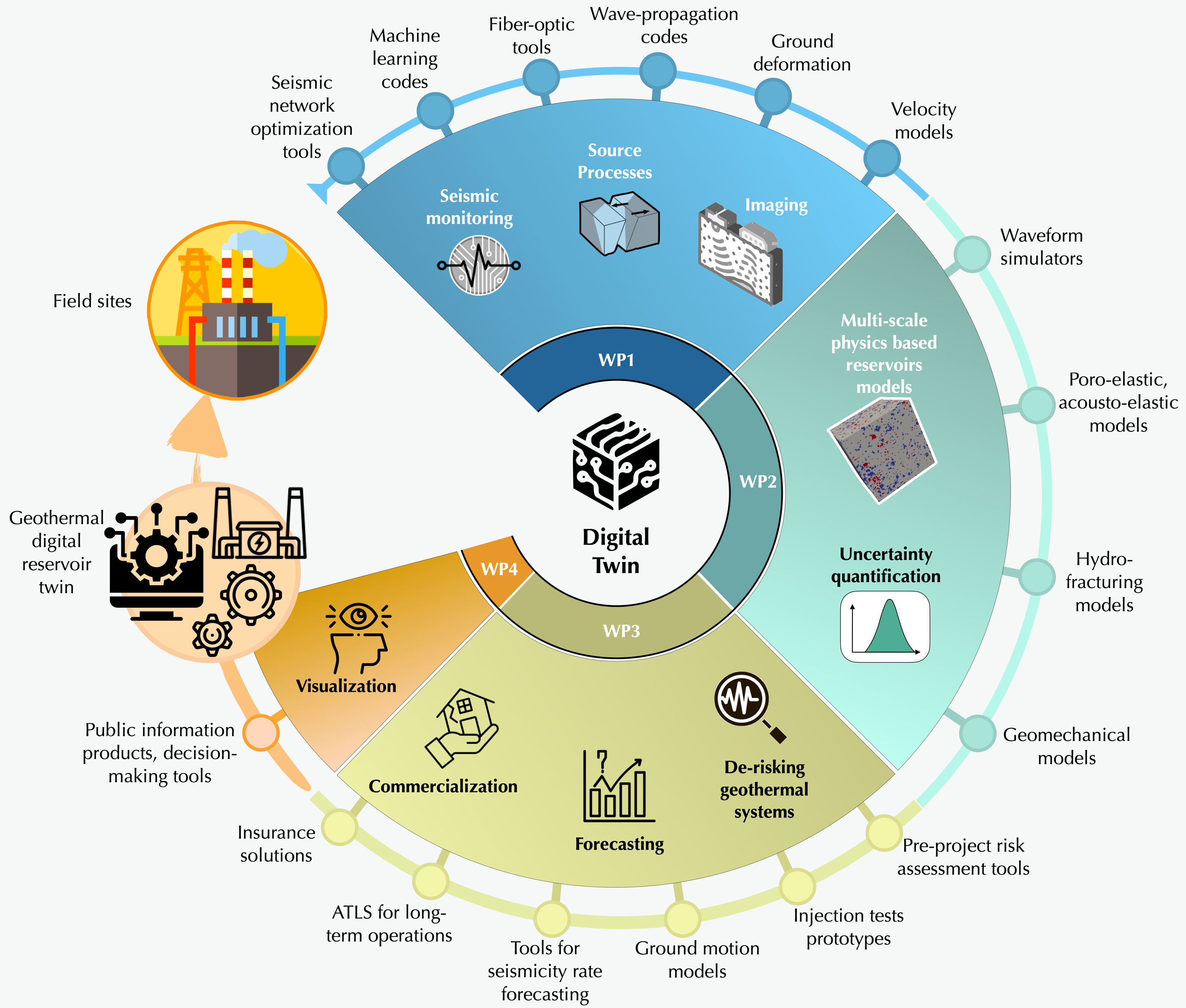
Deep geothermal energy (DGE) holds promise to become a widespread and abundant energy source for heating and power, representing a key technology in the transition to climate neutrality by 2050. However, the widespread roll-out of DGE is challenged in many nations because of closely interrelated concerns about induced earthquakes, decreasing societal acceptance and economic viability due to inadequate production rates and high costs. Digital Twins (DTs) offer an innovative solution to these challenges of optimizing and de-risking deep geothermal energy generation. DTs are calibrated virtual replicas of physical systems that enable the physical interpretation of real-time monitoring data and predictive analyses using high-fidelity models to support decision-making. GEOTWINS aims to create modular and interoperable digital twin components (DTC), tailored for geothermal systems, and demonstrate them at TRL levels 7-8 in diverse operational environments. By integrating prior experience, data and physics-based models, we aim to comprehensively represent geothermal systems as calibrated and validated DTC. The DTC-based workflows can then guide operators and regulators in every project stage, from exploration and licensing to stimulation, circulation, and post-production. GEOTWINS will also develop open-source visualization and decision-making tools to facilitate clear communication with both the population and stakeholders. Ultimately, the objective of GEOTWINS is to create for the first time an accurate and dependable digital representation of deep geothermal reservoirs connected to real-time data flows. GEOTWINS tackles this ambitious goal by bringing together into a multi-disciplinary and multi-national team leading scientists in DGE-related processes, experts in DTC technologies and practitioners from industry.

SED Projektleitung

Stefan Wiemer

Forschungspartner

ETH, CNRS/EOST, GFZ, IEG, HBO, INGV, UNITN, DIAS, EOS, UUTAH

Industry Partners

GES, MONDAIC, SEISMIX, DMT, VITO

Finanzierung

CETPartnership

Zeitdauer

Dec 2024 - Dec 2027

Stichwörter

Deep geothermal energy, Digital Twins, Geothermal systems, Induced seismicity

Bereich

Induced Seismicity, Geomechanical Modelling, Communication

Schweizerischer Erdbebendienst
Sonneggstrasse 5
CH-8092 Zürich
Tel. SED Sekretariat
+41 44 633 21 79 (zu Bürozeiten)

Impressum | Disclaimer  | ©2024 ETH Zürich