News Archive 2023
2023-12-22
Merry Christmas and a Happy New Year
With the earthquake risk model published in 2023, Switzerland is one of the first countries in the world to have an openly accessible basis for making informed decisions in the field of earthquake preparedness and event management.
We wish you a Merry Christmas and a Happy New Year.
Swiss Seismological Service at ETH Zurich
Read more...Hazard and risk are two different terms, which we illustrate in our explanatory video using a bear: A bear in the forest is a potential hazard because it could harm you. However, it only becomes a risk when you enter the forest.
The Christmas wreaths mark the areas with the greatest earthquake risk – the urban areas. Earthquake risk quantifies the potential impact of earthquakes on buildings and the associated financial and human losses. Although the earthquake risk differs in these regions, due to their size, all five cities are home to a large number of people and assets that would be affected by an earthquake. In addition, there are many buildings in these cities, some of which are particularly vulnerable and often located on soft ground that amplifies earthquake waves.

2023-10-31
Indonesian government and World Bank visit SED
As part of a study tour to Switzerland, a delegation from the Indonesian government visited the Swiss Seismological Service (SED) at ETH Zurich, among other destinations. The tour, supported by the World Bank, was designed to promote knowledge exchange on disaster risk management and financial resilience. Indonesia wants to use the newly acquired knowledge and experience from Switzerland to better protect itself against future disasters.
Read more...Indonesia, with its more than 6,000 islands, is located on the Pacific Ring of Fire. As a result, the country is exposed to many natural hazards, including earthquakes, tsunamis, landslides, floods and volcanic eruptions. According to the World Bank, such disasters claimed over 7,000 lives and displaced 55 million people between 2007 and 2018. This was accompanied by annual economic losses of USD 2.2 to 3 billion, equivalent to around 0.2 to 0.3% of the country's gross domestic product (GDP) in 2018. The aim is to strengthen Indonesia's financial, physical and social resilience in order to better protect the island nation's 265 million inhabitants from potential risks.

2023-09-09
[Available in DE/FR] Starkes Erdbeben in Marokko
Im Hohen Atlas Gebirge in Marokko, rund 70 km südwestlich von Marrakesch, hat sich in einer Tiefe von rund 18 km heute Morgen früh um 00:11 Uhr (Schweizer Zeit) ein Erdbeben der Magnitude 6.8 ereignet.
Read more...Die Erschütterungen sind weitläufig verspürt worden, speziell in der Millionenstadt Marrakesch, aber auch in den Küstenstädten Casablanca, Rabat und Agadir am Atlantik. Verspürt wurde das Erdbeben auch im östlichen Nachbarland Algerien sowie in Spanien und Portugal, rund 1000 km entfernt vom Epizentrum. Zudem ereignete sich in der Nähe vom Hauptbeben, rund 20 Minuten später, um 00:31 Uhr (Schweizer Zeit), ein stärkeres Nachbeben mit einer Magnitude von 4.9. Weitere Nachbeben sind in den kommenden Tagen und Wochen zu erwarten. In dieser Region sind Erdbeben zwar eher selten, es gibt aber bekannte grosse Verwerfungszonen.
Die abgelegene Bergregion in der Nähe der Bruchzone ist besonders stark betroffen, denn dort lebt die Bevölkerung mehrheitlich in Häusern aus Lehmziegel oder Lehmkonstruktionen mit unverstärkten Ziegelsteinen, welche stark anfällig für Erdbebenerschütterungen sind. Deshalb kann bei einem Erdbeben dieser Stärke die Zahl der Todesopfer und Verletzten hoch ausfallen. Neben den Bergregionen weist gemäss Medienmeldungen auch die Millionenstadt Marrakesch hohe Opferzahlen auf.
![[Available in DE/FR] Starkes Erdbeben in Marokko](/export/sites/sedsite/home/.galleries/img_news_2023/IntensityMap_Marokko.png_2063069299.png "[Available in DE/FR] Starkes Erdbeben in Marokko")
2023-08-25
Visit us at Scientifica!
This year it's time again: On 2 and 3 September, Switzerland's largest science festival takes place at three locations of ETH and the University of Zurich. At over 60 exhibition booths and other events, you will experience current research on the topic of "What holds the world together". We from the Swiss Seismological Service at ETH Zurich are also taking part and will be exploring the question of how we can manage earthquakes together at our exhibition booth and in a short lecture.
Read more...Earthquakes shake the world without warning. Switzerland's first publicly accessible earthquake risk model shows the effects earthquakes can have on people and buildings. It creates a valuable basis for the population, authorities, and the economy to better prepare Switzerland for earthquakes and to manage them with joint forces in the event of an incident. Where is the earthquake risk highest? What to do when the earth shakes? You will find answers to these and other questions at our exhibition booth on the ETH Polyterrasse. Get a better understanding of the expected impacts of earthquakes and learn in a playful way what measures you can take at home to be better prepared for the next earthquake.
You will receive further information on the topic at the short lecture by Prof. Stefan Wiemer, Director of the Swiss Seismological Service. The short lecture takes place on Sunday, 3 September, at 2 p.m., at the ETH Campus Hönggerberg (admission without ticket).
You will receive further information on the topic at the short lecture by Prof. Stefan Wiemer, Director of the Swiss Seismological Service. The short lecture will take place on Sunday, 3 September, at 2 p.m. on the ETH Hönggerberg campus (in German, no ticket needed).
More informationen
2023-08-25
[Available in DE/FR] Spürbares Erdbeben nahe der Schweizer Grenze
Am Freitag, dem 25. August 2023, hat sich um 3:10 Uhr (Ortszeit) zwischen Singen und Radolfzell am Bodensee (D), in einer ungefähren Tiefe von 10 km ein Erdbeben der Magnitude 3.4 ereignet. Die Erschütterungen des Bebens waren auch in der Schweiz leicht zu spüren, insbesondere in der Region Schaffhausen. Bei einem Erdbeben dieser Magnitude sind keine Schäden zu erwarten.
Read more...Dieses Beben ist das bisher Stärkste einer seit einigen Monaten aktiven Sequenz in der Nähe von Singen, gefolgt von dem Magnitude 3.2 Beben am 29. Juni 2023 und einem Beben am 27. Juni 2023 mit einer Magnitude von 3.1. Beide Beben wurden ebenfalls bis in die Schweiz verspürt.
![[Available in DE/FR] Spürbares Erdbeben nahe der Schweizer Grenze](/export/sites/sedsite/home/.galleries/img_news_2023/2023_08_24_Beben_Singen.png_2063069299.png "[Available in DE/FR] Spürbares Erdbeben nahe der Schweizer Grenze")
2023-06-29
[Available in DE] Mehrere spürbare Erdbeben bei Singen (D)
Am Donnerstag, 29. Juni 2023 hat sich um 17:57 Uhr (Ortszeit) 2 km östlich von Singen (D), in einer ungefähren Tiefe von 10 km ein Erdbeben der Magnitude 3.2 ereignet. Die Erschütterungen des Bebens waren auch in der Schweiz, vor allem in der Region Schaffhausen, zu spüren. Innerhalb einer Stunde nach dem Erdbeben sind beim Schweizerischen Erdbebendienst (SED) an der ETH Zürich über 30 Verspürtmeldungen eingegangen. Bei einem Erdbeben dieser Magnitude sind keine Schäden zu erwarten.
In der gleichen Gegend haben sich seit Dienstag mehrere kleinere Beben ereignet: ein Erdbeben der Magnitude 3.1 am Dienstagmittag und eines der Magnitude 2.6 am Donnerstagabend um 17:28 Uhr. Beide Beben wurden ebenfalls bis in die Schweiz verspürt.
![[Available in DE] Mehrere spürbare Erdbeben bei Singen (D)](/export/sites/sedsite/home/.galleries/img_news_2023/SingenShakeMap.png_2063069299.png "[Available in DE] Mehrere spürbare Erdbeben bei Singen (D)")
2023-06-21
Public earthquake early warning app launched in Costa Rica
Earthquakes are the deadliest natural hazard in Central America, both due to their direct impact and as a cause of possibly devastating tsunamis. Since 2016, researchers at the SED have been working with partners in Central America to build Earthquake Early Warning systems across the region through the “Alerta Temprana de Terremotos en America Central” (ATTAC) project, funded by the Swiss Agency for Development and Cooperation. Last week, a major milestone was reached – the Volcanological and Seismological Observatory (OVSICORI) at the National University in Costa Rica announced the public launch of a smartphone app that can deliver earthquake early warnings across Costa Rica.
Read more...Early earthquake warning system
Potentially damaging seismic waves travel at speeds of two to three kilometres per second, very fast but much slower than information, which travels at the speed of light. Modern seismic networks can detect an ongoing earthquake within a few seconds and issue a warning that can overtake the earthquake waves and provide seconds of warning in advance of strong shaking to areas at some distance from the epicentre. This allows individuals receiving the alert to take immediate action to protect themselves or to initiate automated actions to protect machinery. To successfully operate an earthquake early warning system requires a dense network of high-quality and low-latency seismic stations and dedicated software that can process in real-time the information and issue a warning. The two open-source data processing algorithms used now in Costa Rica are the Virtual Seismologist and FinDer. Both have been developed and optimised at SED over the past ten years. They are also being used by other national earthquake monitoring agencies in Central America: INETER in Nicaragua, MARN in El Salvador, and INSIVUMEH in Guatemala.
A key element of an earthquake early warning system is the ability to deliver warnings to users instantly. Within the ATTAC project, a dedicated smartphone app was developed. It is currently only available on Android phones, the most common smartphone in Central America. The app also provides safety recommendations – in Costa Rica, this is to ‘Duck, Cover and Hold’ – and allows users to report the intensity of ground motions they actually felt.
Further developments
Although now publicly released, the app will continue to be developed further as experiences are gained on how to operate and optimise the performance as the number of users increases on the national scale. Planned improvements before the end of the project in mid-2024 include support for other phone types and translation into indigenous languages. Other partners will probably also announce their own public early warning systems before the project ends.
In Switzerland, earthquake early warning is also considered as a means to reduce earthquake risk. The SED is currently internally testing a prototype system. However, in Switzerland, strong earthquakes occur much less frequently, and for a typical magnitude 6 earthquake, most damage will occur within 10-15 kilometres of the event, inside the so-called blind zone. This is limiting the usefulness of the early warning system when compared to Central America. Nevertheless, the experiences gained in ATTAC will provide valuable input to develop an earthquake early warning system for Switzerland.
More information

2023-06-01
[Available in DE/FR] Erdbeben bei Mulhouse (F)
Der Schweizerische Erdbebendienst (SED) an der ETH Zürich hat in Frankreich, ungefähr 15 km nordwestlich von Basel ein Erdbeben registriert. Das Beben ereignete sich am 1. Juni 2023 um 14:48 Uhr (Ortszeit) mit einer Magnitude von etwa 3.6 auf der Richterskala. Dieses Erdbeben wurde über Basel hinaus bis nach Aarau verspürt. Schäden sind bei einem Erdbeben dieser Stärke in der Regel nicht zu erwarten.
Bei dem Beben handelt es sich um das bisher stärkste Nachbeben des Erdbebens mit einer Magnitude von 4.7 vom 22. September 2022. Die Beben stehen in tektonischem Zusammenhang mit dem seismisch aktiven Rheingraben, der sich zwischen den Vogesen und dem Schwarzwald in nordsüdlicher Richtung erstreckt. Erdbeben sind in dieser Region nichts Aussergewöhnliches.
![[Available in DE/FR] Erdbeben bei Mulhouse (F)](/export/sites/sedsite/home/.galleries/img_news_2023/20230601_Mulhouse-F_EN.jpg_2063069299.jpg "[Available in DE/FR] Erdbeben bei Mulhouse (F)")
2023-05-29
[Available in DE/FR] Spürbare Erdbeben bei Porrentruy und Zinal
Am Montag den 29. Mai 2023 hat sich um 21:16 Uhr (Ortszeit) 14 km südwestlich von Porrentruy (JU), direkt an der französischen Grenze, in einer ungefähren Tiefe von 6 km ein Erdbeben mit der Magnitude 3.8 ereignet. Die Erschütterungen des Bebens waren im Jura deutlich zu spüren. Auch aus dem westlichen Mittelland bis nach Lausanne und Thun, gab es Meldungen, dass das Beben verspürt wurde. Schäden wurden bisher nicht gemeldet. Bei einem Erdbeben der Stärke 3.8 können möglicherweise in der Nähe des Bebens kleinere Schäden auftreten, ernsthafte Schäden sind aber nicht zu erwarten.
Read more...Das Beben ist das drittgrösste in der seit Dezember 2021 in der Ajoie aktiven Réclère Sequenz. Stärker waren nur das initiale Beben vom Weihnachtstag 2021 mit einer Magnitude von 4.1 und das Beben vom 22. Maerz 2023 mit einer Magnitude von 4.3, das stärkste seit 100 Jahren in dieser Region.
Etwa zwei Stunden zuvor, um 18:29 Ortszeit, ereignete sich ein Beben der Stärke 3.1 bei Zinal (VS) im Val d’Anniviers, in etwa 7 km Tiefe. Dieses Beben, das in der Region leicht verspürt wurde, gehört zu einer seit einigen Jahren aktiven Sequenz, mit dem bisher stärksten Beben mit einer Magnitude 3.2 im August 2022.
![[Available in DE/FR] Spürbare Erdbeben bei Porrentruy und Zinal](/export/sites/sedsite/home/.galleries/img_news_2023/20230523_Porrentruy.png_2063069299.png "[Available in DE/FR] Spürbare Erdbeben bei Porrentruy und Zinal")
2023-03-23
[Available in DE/FR] Weiträumig verspürtes Erdbeben bei Porrentruy (JU)
Am Mittwoch dem 22. März 2023 hat sich um 15:50 Uhr (Ortszeit) bei Réclère (JU), 12 km südwestlich von Porrentruy (JU), in einer ungefähren Tiefe von 6 km ein Erdbeben der Magnitude 4.3 ereignet.
Die Erschütterungen des Bebens waren im Jura deutlich zu spüren. Auch aus dem westlichen Mittelland bis nach Lausanne, Bern, Luzern und Zürich gab es Meldungen, dass das Beben verspürt wurde. In der ersten Stunde nach dem Erdbeben sind beim Schweizerischen Erdbebendienst an der ETH Zürich über 1'000 Verspürtmeldungen eingegangen, Schäden wurden bisher nicht gemeldet. Bei einem Erdbeben der Stärke 4.3 können möglicherweise in der Nähe des Bebens kleinere Schäden auftreten, ernsthafte Schäden sind aber nicht zu erwarten.
Read more...In den ersten fünf Tagen hat der SED zu diesem Beben sieben Nachbeben gemessen. Die beiden stärksten davon (22. März 2023: Magnitude 2.4; 27. März: Magnitude 3.0) wurden von der Bevölkerung in der Epizentralregion teilweise leicht verspürt. Weitere Nachbeben sind durchaus wahrscheinlich.
In der Ajoie wurden vor allem seit Dezember 2021 immer wieder Beben gemessen. Das Beben vom 22. März 2023 ist das stärkste, das in den vergangenen 100 Jahren in dieser Region aufgezeichnet wurde. In den nächsten Stunden und Tagen sind Nachbeben nicht auszuschliessen. Das letzte grössere, ebenfalls weiträumig verspürte Beben ereignete sich am Weihnachtstag 2021 mit einer Magnitude 4.1. Damals wurden über die nächsten Tage nur wenige Nachbeben registriert.
(Letzte Aktualisierung: 28.03.2023)
![[Available in DE/FR] Weiträumig verspürtes Erdbeben bei Porrentruy (JU)](/export/sites/sedsite/home/.galleries/img_news_2023/JuraBeben20230323.png_2063069299.png "[Available in DE/FR] Weiträumig verspürtes Erdbeben bei Porrentruy (JU)")
2023-03-17
[Available in DE/FR] Erneut ein Erdbeben bei Rossens (FR)
Am Donnerstag, 16. März 2023, um 23:11 Uhr (Lokalzeit) kam es erneut zu einem Erdbeben in der Nähe von Rossens (FR). Das Beben fand etwa 3 Kilometer westlich von Rossens (FR) und 14 Kilometer südwestlich von Fribourg statt. Es hatte eine Magnitude von 3 und ereignete sich in einer Tiefe von etwa 2 Kilometern.
Innerhalb der ersten Stunde nach dem Erdbeben sind beim Schweizerischen Erdbebendienst (SED) an der ETH Zürich mehr als 250 Verspürtmeldungen eingegangen. Die Berichte über Erschütterungen stammen überwiegend aus dem Gebiet um Rossens, Vuisternens-en-Ogoz, Treyvaux, Cottens (FR), Ecuvillens, Rueyres-Saint-Laurent und Corpataux. Bei einem Erdbeben dieser Stärke ist in der Regel nicht mit Schäden zu rechnen.
Read more...Das letzte spürbare Beben in der Region ereignete sich am 4. März 2023 mit einer Magnitude von 2,7 in einer Tiefe von etwa 4 Kilometern (siehe Aktuellbeitrag vom 5. März). Zuvor ereignete sich ein Beben mit ähnlicher Magnitude (2.6) am 19. August 2009 in einer Tiefe von 6 Kilometern. Diese Region ist aufgrund ihrer geologischen Beschaffenheit anfällig für Erdbeben. Das Molassebecken, ein Sedimentbecken, wird von Nord-Süd verlaufenden Verwerfungen und Störungen durchzogen, was ein bedeutender Faktor dafür ist, dass Erdbeben in diesem Gebiet häufig vorkommen.
![[Available in DE/FR] Erneut ein Erdbeben bei Rossens (FR)](/export/sites/sedsite/home/.galleries/img_news_2023/ErdbebenRossens_16032023.png_2063069299.png "[Available in DE/FR] Erneut ein Erdbeben bei Rossens (FR)
© SED")
2023-03-09
Earthquake risk model of Switzerland now released
On 7 March 2023, after several years of intensive research, the Swiss Seismological Service (SED) at ETH Zurich, together with the Federal Office for the Environment (FOEN) and the Federal Office for Civil Protection (FOCP), published Switzerland's first publicly accessible earthquake risk model (see news article of 7 March).
In the course of the publication, numerous products were made available that make it possible to explore the earthquake risk in Switzerland. A brief description and direct links can be found below. In addition, two events were held on this day to present the model to the media and to professionals. A selection of TV reports is linked below. At the event for professionals, more than 250 participants from the federal government, cantons, industry and academia learned more about the sub-components of the earthquake risk model, the results, the products developed and their areas of application. In addition, the benefits of the model and its contribution to earthquake preparedness and risk management were highlighted from different perspectives.
Read more...The earthquake risk model and its results explained
- The most important information concerning earthquake risk in Switzerland can be found here or in the information brochure “Earthquake risk Switzerland: What are the likely effects of earthquakes in Switzerland? (PDF)“
- A video informing about earthquake risk in Switzerland can be viewed here (in German).
- Determine your personal earthquake risk (approximate value) using our interactive tool.
- Explore maps of earthquake risk, earthquake hazard, amplification factors and more.
- A total of 59 scenarios illustrate the possible effects of earthquakes in Switzerland.
- A detailed scientific report on the earthquake risk model can be found here: www.doi.org/10.12686/a20
TV reports
2023-03-07
Earthquake impacts in Switzerland systematically determined for the first time
Until now, little has been known about the effects that earthquakes in Switzerland could have on people and buildings. At the request of the Federal Council, the Swiss Seismological Service (SED) at ETH Zurich together with the Federal Office for the Environment (FOEN), the Federal Office for Civil Protection (FOCP), EPFL and other partners from industry have developed the first publicly accessible and – to date, most reliable – earthquake risk model for Switzerland. The model provides a new tool enabling the public, authorities and businesses to prepare for earthquakes and to better cope with the next damaging quake.
Read more...Statistically speaking, every person in Switzerland will experience at least one earthquake causing serious damage in their lifetime. This means that earthquakes are among the greatest risks facing Switzerland, along with pandemics and power shortages. Although they occur less frequently than other natural hazards, they can cause significant damage. The model now being published makes it possible for the first time to soundly quantify expected earthquake damages. While earthquake hazard estimates how often and how strongly the ground could shake at given locations in the future, earthquake risk describes the effects on people and buildings. The earthquake risk model combines detailed information on earthquake hazard, the influence of local subsoil, the vulnerability of buildings, and the people and assets affected.
Greatest risk in urban areas
According to the new model, the greatest earthquake risk is in the cities of Basel, Geneva, Zurich, Lucerne and Bern, in that order. Although the earthquake hazard in these regions differs, all five cities have, by virtue of their size, a large number of people and assets that would be affected by an earthquake. In addition, these cities have many buildings, some particularly vulnerable and often located on soft ground that amplifies seismic waves.
The greatest building damage from earthquakes is expected in the cantons of Bern, Valais, Zurich, Vaud and Basel-Stadt. They account for around half of the estimated financial losses. According to the model calculations, over a period of 100 years, earthquakes can be expected to cause economic damage of CHF 11 to 44 billion to buildings and their contents (such as furniture) alone. In total, around 150 to 1,600 people would lose their lives and an estimated 40,000 to 175,000 would become homeless on a short-term or long-term basis. On top of this, there is damage to infrastructure and losses due to other effects of earthquakes such as landslides, fires or business interruptions. However, these are not yet included in the model. The earthquake risk is not evenly distributed over time, but is dominated by rare, catastrophic earthquakes that usually happen without warning.
Products and benefits
As well as compiling risk assessments for specific periods and locations, the SED can now use the earthquake risk model to develop scenarios. Among other things, this makes it possible to illustrate the effects that damaging historical earthquakes in Switzerland would have if they occurred today. For example, if the magnitude-6.6 Basel earthquake of 1356 were to be repeated, the expected death toll in Switzerland would be around 3,000, with building damage totalling approximately CHF 45 billion. However, severe earthquakes could in theory occur anywhere. The SED therefore provides a scenario for a damaging magnitude-6 earthquake for every cantonal capital and one other locality in each canton. Such an earthquake happens on average every 50 to 150 years somewhere in Switzerland or its neighbouring regions. These scenarios, 59 in total, are intended to help make the authorities and public more aware about the impacts of damaging earthquakes in Switzerland.
Based on the earthquake risk model, the SED will publish Rapid Impact Assessments (RIA) after each earthquake with a magnitude of 3 or greater. The RIA will inform the public and emergency services about the expected impacts in the event of damaging earthquakes, or quakes that can be felt over a wide area. Isolated damage is possible near the epicentre with quakes of around magnitude 4 or above. It is also possible to determine the risks for building portfolios or to produce detailed scenarios for cities and built-up areas. Switzerland thus becomes one of the first countries in the world to have a freely accessible resource for making informed decisions on earthquake mitigation and event response.
Model development
The processing of the underlying data was key to the development of the earthquake risk model for Switzerland. Over 3 million individual earthquakes that could potentially occur in Switzerland and neighbouring regions were simulated. Switzerland's more than 2 million residential, commercial and industrial buildings were divided into vulnerability categories according to certain criteria in order to be able to model the possible damage caused by earthquakes. In addition, improved data on the amplifying effects of the subsoil conditions provide a significantly better picture of local impacts. However, despite the improved data, uncertainties in the modelling mean that there are likely to be differences compared with the actual impacts. The earthquake risk model will be further refined in the coming years to reduce these uncertainties and so improve the model results.
The earthquake risk model is part of the federal government's programme of measures for earthquake mitigation, coordinated by the FOEN, the aim of which is to ensure comprehensive seismic risk management at federal level. The findings from the earthquake risk model will therefore feed into the national risk analysis and to the planning of earthquake mitigation at federal and cantonal levels. They provide a common basis for determining how authorities, the public and businesses can deal with the effects of a damaging earthquake and reinstate destroyed or damaged buildings and infrastructure. In addition, the national earthquake risk model will provide key input for planning and implementing the work of the Schadenorganisation Erdbeben (SOE), which is currently being set up. After an earthquake, the SOE will estimate the expected costs of building damage so that reconstruction can get under way quickly.
Documents for download:
Map Earthquake Risk Switzerland (high res)

2023-03-05
[Available in DE/FR] Erdbeben bei Rossens (FR)
Am Samstag, dem 04. März 2023 hat sich um 23:32 Uhr (Ortszeit) 3 km westlich von Rossens (FR), südwestlich von Fribourg, in einer ungefähren Tiefe von 4 km ein Erdbeben der Magnitude 2.7 ereignet.
Beim Schweizerischen Erdbebendienst an der ETH Zürich sind vorwiegend Verspürtmeldungen aus Farvagny und der näheren Umgebung eingegangen. Innerhalb der ersten Stunde nach dem Erdbeben sind 50 Verspürtmeldungen eingetroffen. Bei einem Erdbeben dieser Stärke sind in der Regel keine Schäden zu erwarten.
Das letzte spürbare Beben im Gebiet um Rossens wurden am 19. August 2009 mit einer Magnitude von 2.6 in einer Tiefe von 6 km registriert. In dieser Region kommt es immer wieder zu Erdbeben, die im Zusammenhang mit einer grob Nord-Süd verlaufenden Verwerfungszone stehen. Die meisten Erdbeben ereignen sich dabei an der Grenze zwischen dem kristallinen Untergrund und den Sedimenten des Molassebeckens.
![[Available in DE/FR] Erdbeben bei Rossens (FR)](/export/sites/sedsite/home/.galleries/img_news_2023/ErdbebenRossens_fig.png_2063069299.png "[Available in DE/FR] Erdbeben bei Rossens (FR)")
2023-03-01
[Available in DE/FR] Erdbeben bei Tiefencastel (GR)
In der Nähe von Tiefencastel (GR), wurde am Mittwoch, 1. März 2023 um 22:02 Uhr (Lokalzeit) ein Erdbeben der Stärke 2.6 in einer Tiefe von etwa 6 Kilometern gemessen.
Beim Schweizerischen Erdbebendienst an der ETH Zürich sind vorwiegend Verspürtmeldungen aus Savognin (GR) und der näheren Umgebung eingegangen. Innerhalb einer Stunde gab es 60 Verspürtmeldungen. Bei den meisten Verspürtmeldungen berichteten die Menschen von einem leichten Schütteln und dass sie überrascht waren. Es gingen zudem vereinzelt Berichte über Knallgeräusche ein. Solche Geräusche entstehen, wenn Erdbebenwellen an die Oberfläche treffen und sind eine häufige Begleiterscheinung von Erdbeben. Die Schwingungen des Bodens werden in die Luft übertragen und erzeugen Schallwellen. Bei einem Erdbeben dieser Stärke sind in der Regel keine Schäden zu erwarten.
![[Available in DE/FR] Erdbeben bei Tiefencastel (GR)](/export/sites/sedsite/home/.galleries/img_news_2023/Tiefencastel_2-6-updated.jpeg_2063069299.jpeg "[Available in DE/FR] Erdbeben bei Tiefencastel (GR)")
2023-02-10
Possible impacts of strong earthquakes in Switzerland
Following the devastating earthquakes in the Syria-Türkiye border region, the question of what impacts similar quakes could have in Switzerland is being asked again and again. Based on preliminary results from the seismic risk model for Switzerland, which is due to be published on 7 March 2023, the Swiss Seismological Service at ETH Zurich has calculated two scenarios: a magnitude-7.8 quake, which is not expected to occur, and a repetition of the 1356 earthquake near Basel, with a magnitude of 6.6. An earthquake with a similar magnitude to this can be expected in the Basel region every 2,000 to 2,500 years. Larger quakes up to a magnitude of around 7 are considered possible in Switzerland due to the tectonic conditions. Such an earthquake anywhere in Switzerland or neighbouring regions has an annual probability of occurrence of approximately 0.1%. By contrast, a magnitude-7.8 earthquake is not to be expected. Based on the logarithmic magnitude scale, such an earthquake would be around 63 times stronger than a magnitude-6.6 quake, which would be reflected in the damage caused.
Read more...Modelling indicates that in both scenarios the entirety of Switzerland would be severely affected by the quake, with large-scale destruction likely in the respective epicentral areas. In the Basel scenario, around 77,000 buildings across Switzerland would suffer moderate to severe damage. In the hardest-hit cantons, this would mean up to 70% of the building stock. As a result, there would be approximately 3,000 fatalities and approximately CHF 45 billion of building damage. Further costs would arise from business interruptions or damage to infrastructure. These costs have not yet been modelled. The magnitude-7.8 scenario, which is not expected to occur, would be likely to result in over 15,000 fatalities and damage in the order of CHF 250 billion. Over half a million buildings would suffer moderate to destructive damage. The impacts of a magnitude-7.8 earthquake are greater primarily because such a quake activates a fault line 120 to 180 km in length, compared with around 15 to 30 km for a magnitude-6.6 quake.
The seismic risk model for Switzerland is being developed by the Swiss Seismological Service (SED) at ETH Zurich together with the Federal Office for the Environment (FOEN), the Federal Office for Civil Protection (FOCP), EPFL and other partners from industry. The model, which will be publicly accessible from 7 March 2023, will make it possible for the first time to reliably quantify expected earthquake damage. It will therefore provide a new tool enabling the public, authorities and businesses to prepare for earthquakes and to better cope with the next damaging quake.

2023-02-08
Classification of the 6 February 2023 earthquakes in Türkiye
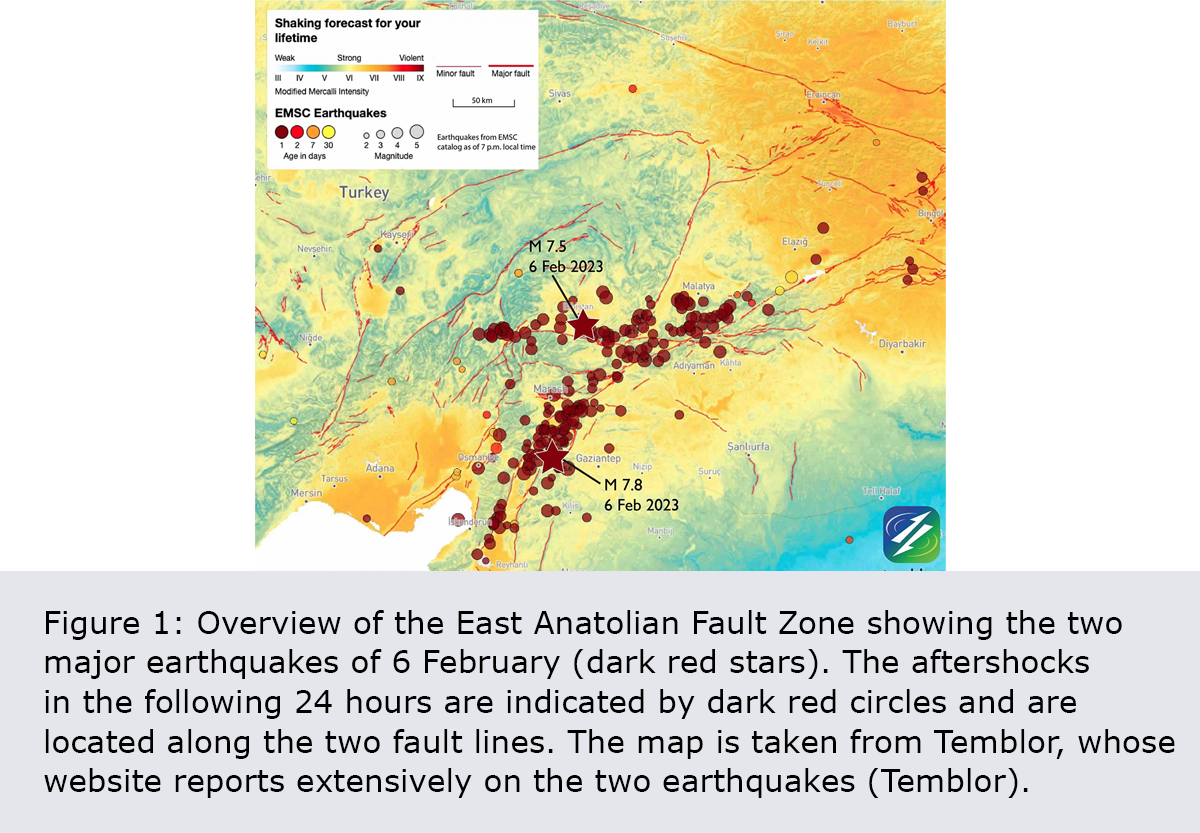
The magnitude-7.8 and magnitude-7.5 earthquakes in Türkiye on 6 February 2023 are devastating events with a massive impact on the lives of millions of people in Türkiye and Syria. The hypocentre of the Gaziantep earthquake (magnitude 7.8) was 18 km below the earth's surface and around 9 km east of Sakçagözü. The hypocentre of the second quake (Kahramanmaraş earthquake, magnitude 7.5) was at a depth of 10 km and about 100 km north of the first major quake, on a second fault line. The metropolis of Gaziantep in Türkiye is very close to the epicentre of the earthquake bearing its name, while Aleppo in Syria is only 100 km away. Another ten major cities are located directly on the fault zone.
Read more...The earthquakes occurred due to the movement of tectonic plates. The region where the earthquakes took place is known as a triple junction, where three tectonic plates meet: the Anatolian, the Arabian and the African. According to current information, the Gaziantep earthquake is believed to have been caused by the movement of the southern part of the East Anatolian Fault Zone (see Figure 1). This fault zone runs through southeastern Türkiye and is responsible for many of the earthquakes that happen in the region. Over time, tremendous underground stresses built up in the fault zone. When these were suddenly released, it triggered the ground motions that caused devastating damage in the region. However, the effects were not only felt locally: as far away as Cyprus, 400 km from the epicentre of the Gaziantep earthquake, a dynamic displacement of approximately 20 cm was measured by GPS (Global Positioning System).
According to preliminary calculations by the United States Geological Survey (USGS), the Gaziantep earthquake caused a large section of the fault to shift by about 3.4 m over a vertical area of around 220 x 30 km (roughly the size of the canton of Grisons). The second earthquake, with a magnitude of 7.5, had a fracture surface of 40 x 20 km (a similar size to the canton of Jura) and a slip of approximately 10 m. As more data becomes available in the coming days, this information on the size and movement of the fracture surfaces will be further refined and is therefore liable to change significantly.
The earthquakes brought down many buildings. In the city of Kahramanmaraş, for example, an estimated 16,000 buildings have been damaged (Report 6.2.23, Kandilli Observatory and Earthquake Research Institute). This was due not only to the strength of the shaking but also to inadequate construction. Although Türkiye revised its building standards after the 1999 İzmit earthquake, there are still many older buildings that were constructed prior to this, meaning that their seismic safety is unknown and in many cases inadequate. A similar situation exists in many countries, including Switzerland, since renewal of the building stock is usually a slow process and upgrading existing buildings can be very expensive. Moreover, in Turkish cities, the ground floor is often designed as an open shop area with few load-bearing walls. Such walls are vital to a building's stability. Without them, a strong ground motion can cause the ground floor to collapse, bringing down the entire building.
The earthquakes also caused widespread power outages and communications disruptions, making it difficult for rescue and clearance teams to reach affected areas and coordinate relief efforts. According to the USGS, large areas are also expected to be affected by landslides and soil liquefaction caused by the shaking. Soil liquefaction weakens the subsurface, resulting – like landslides – in additional damage to buildings, roads and infrastructure.
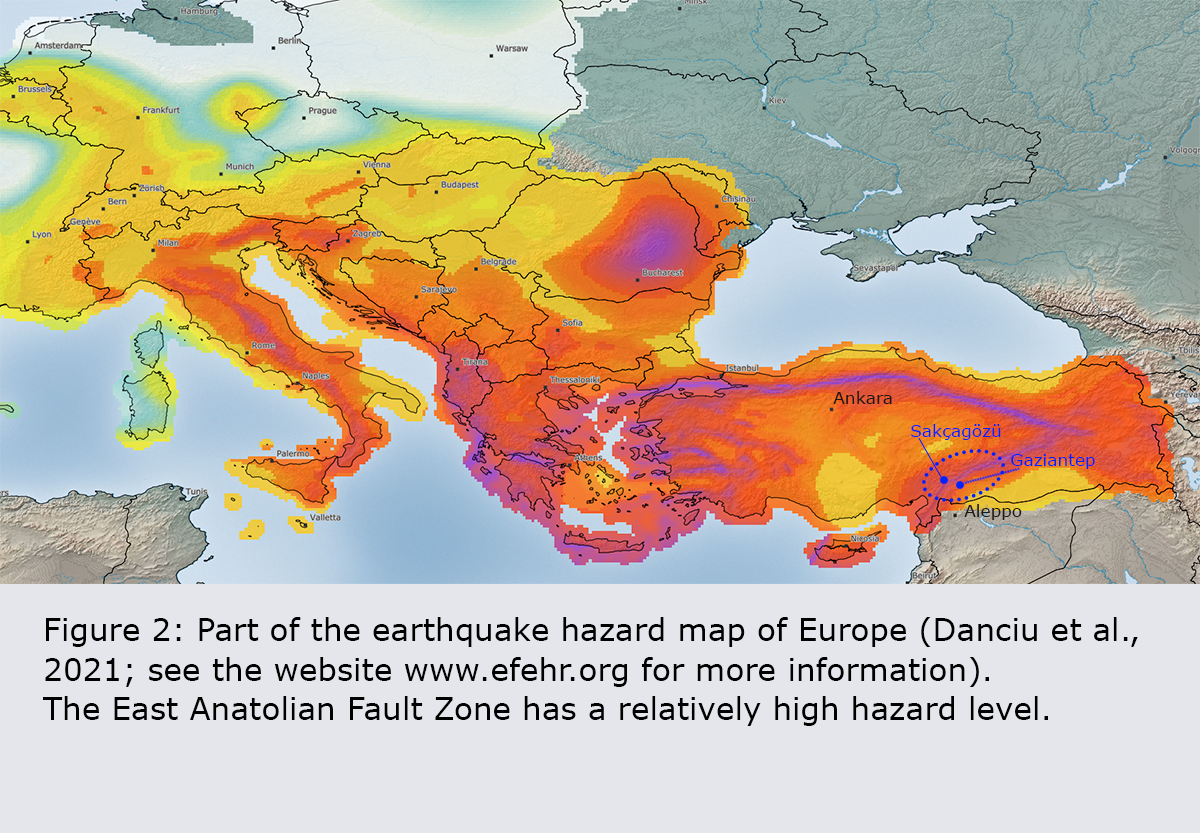
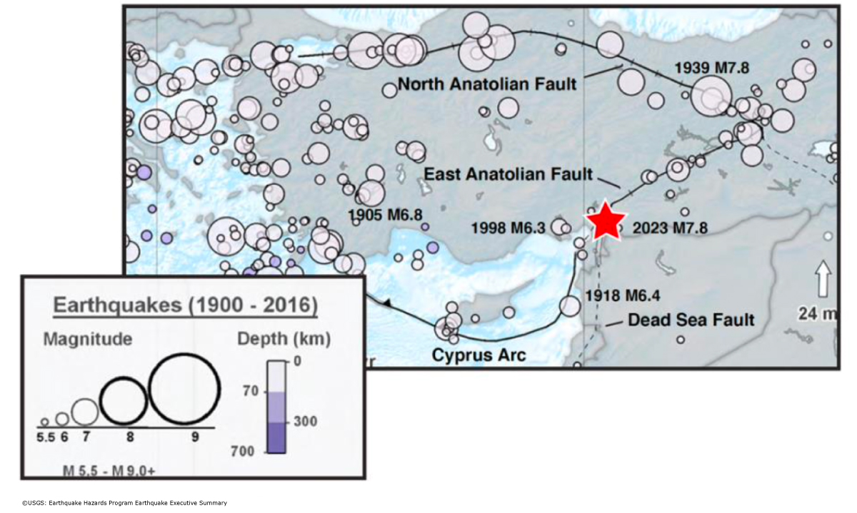
The region has been hit by several strong earthquakes in the past. The last earthquake of comparable strength was in 1939 at Erzincan on the North Anatolian Fault and had a magnitude of 7.8. It was one of the most powerful quakes to hit Turkey in the 20th century, causing major damage in a number of towns and villages. Immediately prior to the two recent earthquakes in southern Turkey, the annual probability of an earthquake with a magnitude greater than 7.7 in this region was 0.13%, compared with 0.25% for an earthquake with a magnitude greater than 7.4 (Danciu et al., 2021). This is rather high by European standards, as can be seen in Figure 2, where the affected region is located in the purple-coloured area. The occurrence of strong earthquakes like those on 6 February is therefore not unexpected. Regions with a lower hazard level are coloured yellow in Figure 2.
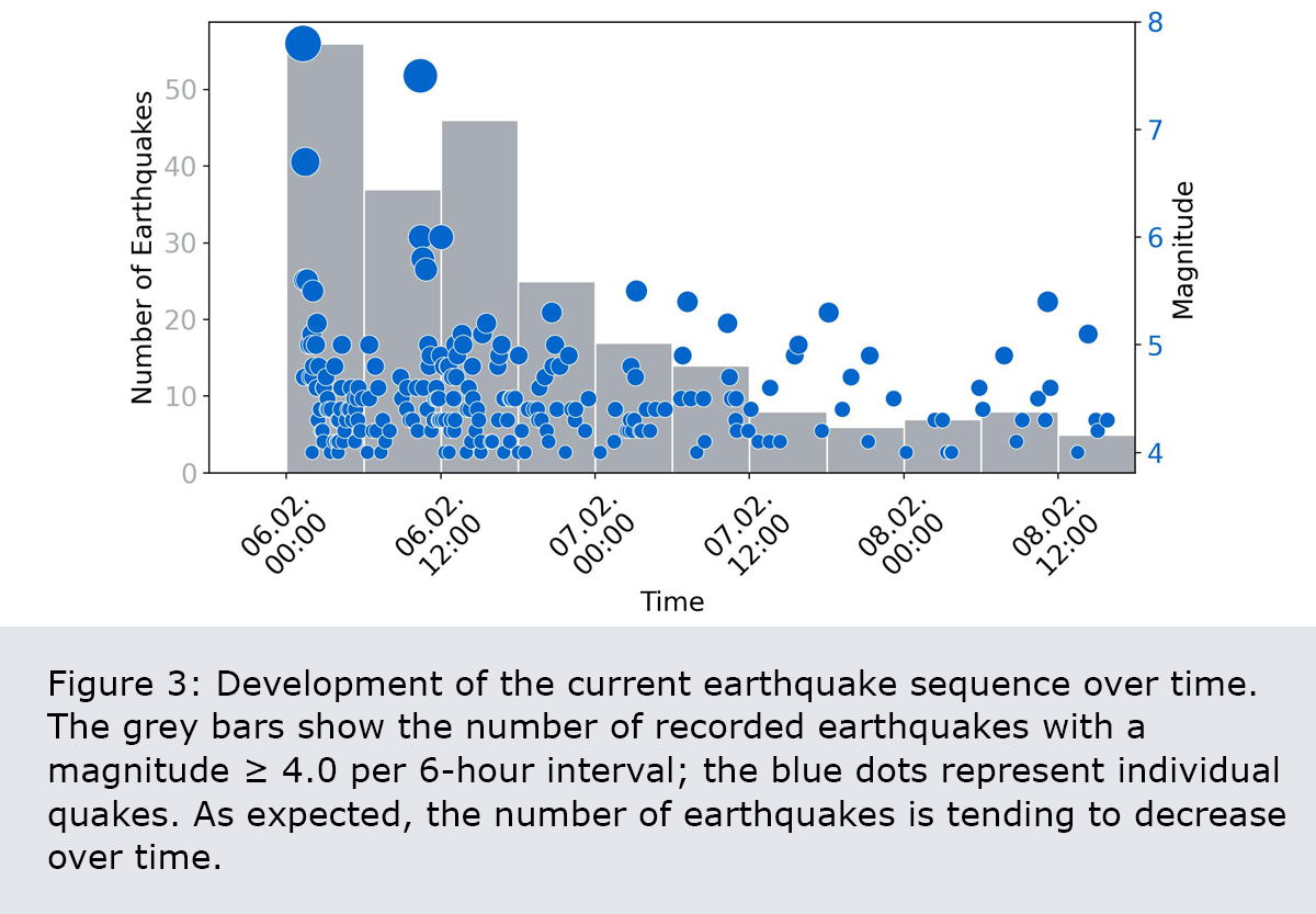
A large earthquake is typically followed by further quakes. It is therefore possible that more earthquakes of a similar or even greater magnitude will occur. Most aftershocks happen within minutes or hours of the mainshock. Further aftershocks can occur for weeks, months or even years afterwards, but their number tends to decrease over time. This pattern is also clearly visible in the current sequence, as shown by the grey bars in Figure 3. The number of earthquakes expected per day is already around 95-97% lower after one week than on the first day. Nevertheless, in rare cases, further major earthquakes can take place.
2023-02-06
[Available in DE] Schweres Erdbeben mit zahlreichen Nachbeben in der südlichen Zentraltürkei
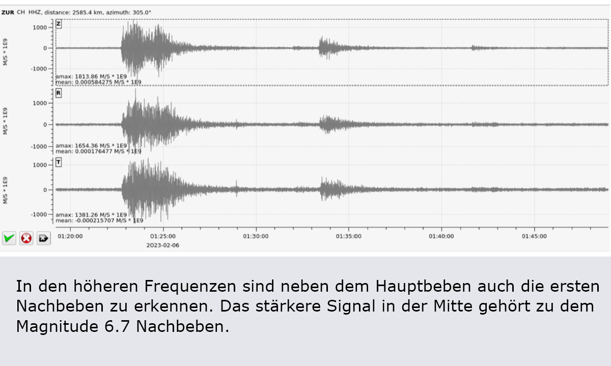
(aktualisiert) Am Montag, den 6. Februar 2023 um 02:17 Uhr Schweizer Zeit hat sich in der Nähe der Stadt Gaziantep in der südlichen Zentraltürkei, rund 50 km nördlich der syrischen Grenze, ein Erdbeben der Magnitude 7.8 ereignet. Dem Hauptbeben folgten bisher dutzende Nachbeben, die ebenfalls die Schadensschwelle erreichten. Darunter ein Beben der Magnitude 6.7, das sich 11 Minuten später ca. 30 km nördlich des Hauptbebens ereignete sowie ein Beben der Magnitude 7.5, welches am selben Tag um 11:47 Uhr auftrat. Nach ersten Erkenntnissen fand dieses starke Nachbeben auf der nach Westen abzweigenden Surgu-Verwerfung statt. Es vergrösserte den Schadensperimeter der Erdbebensequenz deutlich nach Nordwesten. Die Nachbeben-Tätigkeit wird – typischerweise mit abnehmender Intensität – voraussichtlich noch Wochen oder Monate anhalten, wobei auch mit weiteren Beben über der Schadensschwelle gerechnet werden muss. Es ist zudem nicht auszuschliessen, dass sich ein noch stärkeres Beben als das Hauptbeben ereignet, die Wahrscheinlichkeit dafür ist jedoch sehr klein.
Read more...Die schweren Beben waren von Israel bis Kroatien spürbar und haben in einer Region von etwa 400 auf 300 km zu schweren Schäden geführt. Bis Dienstagmittag waren bereits über 5’000 Todesopfer und 25‘000 Verletzte bekannt, davon etwa zwei Drittel in der Türkei und ein Drittel in Syrien. Diese Zahlen werden voraussichtlich noch weiter ansteigen.
Das Magnitude 7.8 Erdbeben hat in einer seismisch aktiven Region stattgefunden, in der sich die Anatolische, Arabische und Afrikanische Platte treffen. Nach bisherigen Erkenntnissen lag das Beben auf der vom Golf von Iskenderun in Richtung Nordosten verlaufenden Ostanatolischen Störung. Ein Beben dieser Grösse versetzt die Erdplatten entlang einer Verwerfung von 180 bis 200 km Länge um mehrere Meter. Der gesamte Bruchvorgang dauerte 30 bis 40 Sekunden, was eine Bruch-Fortpflanzungsgeschwindigkeit weit über Schallgeschwindigkeit ergibt. Die Bruchfläche reichte dabei von einer Tiefe von rund 20 km bis an die Erdoberfläche. Das Beben von letzter Nacht ist eines der stärksten bekannten Beben in der Region. Die bisher grössten historischen Beben mit Magnituden von ungefähr 7 haben in den Jahren 1138 und 1822 die Stadt Aleppo in Syrien komplett verwüstet. Das Beben von 1822 forderte einige zehntausend Todesopfer. Seit 1970 blieb es in der Region verhältnismässig ruhig mit nur drei Beben mit Magnituden von 6 oder mehr. Das grösste davon erschütterte die Region am 24. Januar 2020 mit einer Magnitude von 6.7.
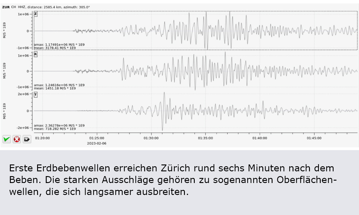
Die ersten Wellen (P-Wellen) der Beben in der Südosttürkei trafen mit einer Verzögerung von gut 5 Minuten in der Schweiz ein, die stärkeren, aber langsameren Oberflächenwellen legten die 2’700 km in etwa einer Viertelstunde zurück. Beim Hauptbeben von Montagnacht wurde die Erdoberfläche in der Schweiz um bis zu einem Zentimeter vertikal ausgelenkt – vergleichbar mit den Bodenbewegungen, die hierzulande nach dem Magnitude 9.2 Beben von Tohoku (Japan) im Jahr 2011 registriert wurden. Allerdings treffen in so grossem Abstand vom Erdbebenherd nur noch langperiodische Wellen ein: Das heisst, die Bodenoberfläche bewegt sich innerhalb von etwa zwei Minuten erst einen Zentimeter nach oben und dann wieder nach unten. Das ist mit geeigneten Seismometern deutlich messbar und kann zur Lokalisierung des Erdbebens wie auch zur Magnitudenbestimmung verwendet werden. Für uns Menschen sind diese Wellen aber weder spürbar noch haben sie irgendwelche Schadensfolgen.
2023-02-01
Earthquakes in Switzerland in 2022
The Swiss Seismological Service (SED) at ETH Zurich recorded around 900 earthquakes last year. Earthquake activity was particularly characterised by events in neighbouring countries, such as the quake near Sierentz (France). With a magnitude of 4.7, this was the fifth strongest earthquake in the recording area since the introduction of modern measurement methods in 1975. The tremors were felt over a wide area. Quakes near Albstadt (Germany), Chamonix (France) and Triesenberg (Liechtenstein) as well as in Haute-Ajoie (canton of Jura) were also clearly felt.
Read more...With around 900 earthquakes recorded, the number of events was slightly lower than in previous years. Of these, 28 (slightly more than the long-term average) had a magnitude of 2.5 or above. Quakes in this range are likely to be felt by the population. Unlike some other years, there were no significant earthquake sequences in 2022, which is a major reason why the number of quakes was somewhat lower. Such fluctuations in earthquake activity are normal and do not allow conclusions to be drawn about future developments.
The quake near Sierentz in Alsace (France) on 10 September 2022 was the fifth strongest event in Switzerland or its neighbouring regions since the start of modern instrumental earthquake recording in 1975. It had a magnitude of 4.7 and was felt in large parts of Switzerland. The SED received 11,000 felt reports from the general public – the highest number to date. This event shares fifth place with an earthquake of the same magnitude that occurred near Vaduz (Liechtenstein) in 1992. The largest earthquakes in Switzerland or neighbouring countries since 1975 happened near Annecy (France) in 1996 and close to Bormio (Italy) in 1999, both with a magnitude of 5.1. Next strongest, with a magnitude of 5.0, is the last damaging earthquake to have had its epicentre in Switzerland, hitting Vaz (canton of Grisons) in 1991. This is followed by an earthquake near Vallorcine (France) (2005, magnitude 4.9) and one near Besançon (France) (2004, magnitude 4.8).
The Sierentz earthquake was linked to a well-known, seismically active tectonic structure, the Rhine Graben, which extends north from the Basel region, between the Black Forest and the Vosges mountain range. Earthquakes are not uncommon in this region, but quakes of a magnitude similar to that experienced last September happen only about once every 10 to 20 years. Historically, large damaging earthquakes have also been documented in this area, such as the one near Basel in 1356 with a magnitude of 6.6. In the centuries that followed, a damaging earthquake occurred about every 50 to 100 years, but since 1650 there have been only a few larger quakes. However, historical evidence and palaeoseismological studies suggest that a quake of similar strength to the one in 1356 can be expected in the region every 2,000 to 2,500 years.
The epicentre of the second largest earthquake in 2022 was near Triesenberg (Liechtenstein). With a magnitude of 3.9, it could be clearly felt not only throughout Liechtenstein but also in Switzerland, as far away as St Gallen and Chur. Of the more than 700 felt reports, some also came from the regions of Schaffhausen, Zurich and Lucerne. The earthquake occurred close to the Earth's surface, meaning that it was felt quite strongly right at the epicentre, but relatively weakly further away. Around 20 seconds before the main tremor on 1 September, there was a 2.1-magnitude foreshock, which was also clearly felt near the epicentre. There followed numerous aftershocks, some of which were perceptible. The largest of these, with a magnitude of 3.1, happened on 14 October. Like the Rhine Graben, the St Gallen Rhine Valley is one of the areas in Switzerland with a relatively high risk of earthquakes. Also clearly perceptible in adjoining parts of Switzerland were a 4.2-magnitude quake near Albstadt (Germany) on 9 July and one near Chamonix (France) with a magnitude of 3.7, which occurred on 25 September.
As well as these quakes in neighbouring countries, a magnitude-3.1 aftershock from the earthquake sequence in Haute-Ajoie (canton of Jura) was clearly felt, especially in the Jura. This sequence began in late 2021. There was also a magnitude-1.6 earthquake near Monthey (canton of Valais) on 25 October, prompting an unusually large number of felt reports. People cannot normally feel an earthquake of this magnitude. The reasons why this quake was clearly perceptible were the time at which it occurred, in the late evening, and its shallow focus, about one kilometre below the Earth's surface.
Fortunately, of the five largest quakes since the instrumental measuring network was established, only the one near Vaz caused (minor) damage in Switzerland. Damaging earthquakes are therefore rare, but they are bound to occur in the future. Until now, little has been known about the effects that earthquakes could have on people and buildings today. In the future, it will be possible to estimate these impacts using the first publicly accessible – and, to date, most reliable – seismic risk model for Switzerland. The model, developed by the SED in cooperation with the Federal Office for the Environment (FOEN), the Federal Office for Civil Protection (FOCP), EPFL and other partners from industry, will be presented to the public on 7 March 2023.
