Natural Local Seismicity
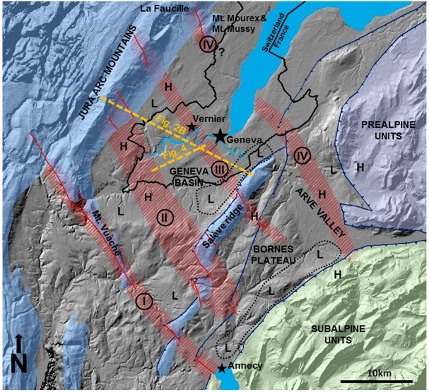
The Geneva Basin, part of the North Alpine Foreland Basin (Swiss Molasse Basin) filled with erosion material from the Alps, is bounded in the northwest by the Jura mountains, in the southeast by Mont Salève and in the southwest by Mont Vuache. In the northeast, it has no clear topographic boundary, merging into the Swiss Molasse Basin along an imaginary line between Mont Mourex and the Arve Valley.
Fig. 1 Tectonic map of the Geneva Basin from Clerc et al. (2015).
Clerc, N., Rusillon, E., Moscariello, A., Renard, P., Paolacci, S., & Meyer, M. (2015). Detailed structural and reservoir rock typing characterisation of the Greater Geneva Basin, Switzerland, for geothermal resource assessment. In: Proceedings of the World Geothermal Congress, Melbourne, Australia, 19–25 April 2015.

Four dominant shear zones are inferred from geological mapping of the Jura mountains and Mont Salève and from geophysical surveys carried out by the oil industry, traversing the Geneva Basin from the northwest to the southeast (Vuache (I), Cruseilles (II), Le Coin (III) and Arve (IV)). Interpretation of the geophysical data suggests that faults have penetrated the entire sedimentary basin and are still in motion today. There is no way of telling from the data whether the faults continue into the crystalline basement rock. Another dominant fault system, linked to Mont Salève's overthrust, crosscuts the Geneva Basin from the southwest to the northeast. Of the aforementioned fault systems, only the Vuache fault appears to be seismically active.
The Earthquake Catalogue of Switzerland (ECOS, 2009) lists 10 earthquakes with intensities of V or greater (slight damage) in the Greater Geneva Basin. The two strongest events occurred south of Geneva outside the basin, attaining magnitudes of 5.2 (1936, Mont Vuache) and 4.8 (1877, Faucigny, France). However, exactly where these historic earthquakes took place is only very roughly indicated.
Most seismic activity recorded since 1975 has occurred outside the Geneva Basin on French territory on the southern shore of Lake Geneva and in the Chablais region. That said, a few earthquakes with magnitudes of 2.5 and more have occurred on the southeastern edge of the Geneva Basin (in the area around Mont Salève and the Vuache fault). The largest such quake occurred on 29 May 1975 and had a magnitude of 4.2 at a shallow depth of less than 2 km. This earthquake was followed around 13 minutes later by an aftershock with a magnitude of 2.9. Another quake occurred in the same area on 8 November 1982, reaching a magnitude of 3.8. With only a few exceptions, earthquakes occurring in the area covered by the study have hypocentral depths of deeper than 10 km. However, some instances of very shallow quakes in the region have also been documented. One such example was the magnitude 5.3 earthquake that occurred on 15 July 1996 at a depth of just 2 km at the southern end of the Vuache fault, near Epagny in France.