News Archive 2020
2020-12-22
Merry Christmas and a Happy New Year
2020-12-17
[Available in DE, IT] Im Tessin verspürtes Beben bei Mailand
Am Donnerstag, dem 17. Dezember 2020, hat sich um 16:59 Uhr (Lokalzeit) etwa 5 km nordwestlich vom Stadtzentrum von Mailand (I) in einer Tiefe von ungefähr 55 km ein Erdbeben der Magnitude 3.9 ereignet. Bei einem Erdbeben dieser Stärke in dieser Entfernung sind in der Regel keine Schäden in der Schweiz zu erwarten.
Aufgrund der recht grossen Tiefe wurden die Erschütterungen im ganzen Tessin deutlich wahrgenommen. Am Schweizerischen Erdbebendienst an der ETH Zürich gingen in den ersten 30 Minuten nach dem Beben ca. 140 Verspürtmeldungen ein.
Auch wenn Erdbeben unter der Po-Ebene nicht unüblich sind, und auch derart tiefe Beben aus der Vergangenheit bekannt sind, wurden in den letzten 20 Jahren keine Beben mit Magnitude 3 oder grösser im weiteren Agglomerationsgebiet von Mailand aufgezeichnet.
2020-12-11
Swiss federal action plan for earthquake mitigation celebrates 20th birthday
Exactly 20 years ago, the Swiss Federal Council approved the federal action plan for earthquake mitigation, in an acknowledgement that in Switzerland, despite the substantial damage an earthquake could cause, the risk of such an event is all too often underestimated. Under the supervision of the Federal Office for the Environment's Coordination Centre for Earthquake Mitigation, the action plan has been further developed on a rolling basis since then and implemented within the competence of the federal government. As the federal agency for earthquake monitoring, the Swiss Seismological Service (SED) at ETH Zurich has played a vital role in establishing an integrated earthquake risk management system in Switzerland.
One key plank of risk management that has been rolled out over the past 20 years as a result of the action plan is the expansion and modernisation of the national seismic network. This now consists of more than 200 seismic monitoring stations, meaning that seismic activity in Switzerland and neighbouring countries can be recorded comprehensively and in real time. This not only helps to ensure that the authorities, the public and the media can be alerted quickly when an event occurs – it also steadily improves the accuracy of earthquake hazard assessments. Seismic hazard models using state-of-the-art techniques and technology and updated in real time play a key part in further improving earthquake mitigation in Switzerland.
Read more...The Federal Council adopted the federal action plan for 2021–24 at its meeting on 11 December 2020, reflecting the federal government's desire to further consolidate earthquake mitigation. Over the next four years, this will see, among other things, precautionary planning for earthquakes and quality assurance for earthquake-resistant construction stepped up. Comprehensive information about the earthquake hazard situation in Switzerland is now available and can be accessed by the public. However, the financial and personal risks that can be expected in the event of an earthquake are still largely unclear because not enough is yet known about the influence of the local subsoil and the vulnerability of buildings, nor are these details available across the country. In this light, the SED is currently developing an earthquake risk model for Switzerland in collaboration with the Federal Office for the Environment and the Federal Office for Civil Protection. Due to be published in 2022, this model is intended to serve as a basis for the federal government and the cantons in the future, with a view to obtaining a quick overview of possible damage in the event of an earthquake. It draws on the regularly updated earthquake hazard assessment and takes into account the influence of the local subsoil as well as the vulnerability and value of buildings and infrastructure. In addition, the earthquake risk model can be used by private companies such as insurance providers to improve their own assessments and services.
Learn more:
-
Press release [available in DE, FR and IT]
2020-12-03
[Available in DE] Neuer CAS Kurs
Bis am Sonntag, 20. Dezember 2020, können sich Interessierte für den Kurs «Erdbebensicherheit im integralen Naturgefahrenmanagement» anmelden. Dieser Kurs ist Teil des «CAS ETH in Angewandten Erdwissenschaften» (Certificate of Advanced Studies), kann aber auch als Einzelkurs besucht werden.
Kursdaten: 08. und 09. sowie 11. und 12. Februar 2021, online (Zoom)
Die Teilnehmenden erhalten einen Überblick, wie die Disziplinen Seismologie, Geologie und Erdbebeningenieurwesen bei der Bewertung der seismischen Gefährdung und Schadensminderung durch erdbebensicheres Bauen ineinandergreifen. Verschiedene Methoden zur Standortcharakterisierung sowie die zur erdbebensicheren Projektierung und Überprüfung von Bauwerken notwendigen Eingabedaten und Richtlinien werden im Kurs beleuchtet. Die Teilnehmenden lernen, den Umgang mit der Erdbebengefährdung im Rahmen des integralen Naturgefahrenmanagements einzustufen und setzen sich mit der Problematik erdbebeninduzierter Naturereignisse auseinander.
Read more...Die Kurse der Modulgruppe Geo-Risiken werden in Zusammenarbeit mit dem Schweizerischen Erdbebendienst organisiert und durchgeführt.
Weiterführende Informationen:
![[Available in DE] Neuer CAS Kurs
© USGS [Available in DE] Neuer CAS Kurs](/export/sites/sedsite/home/.galleries/img_news_2020/20201203_CAS_Kurs_mitBanner.jpg_2063069299.jpg)
2020-11-10
[Available in DE, FR] Erneutes weiträumig verspürtes Erdbeben bei Elm (GL)
Am Dienstag, dem 10. November 2020 hat sich um 13:53 Uhr (Lokalzeit) südwestlich von Elm, in einer geringen Tiefe von ungefähr 1 km, ein Erdbeben der Magnitude 3.9 ereignet.
Die Erschütterungen waren vorwiegend im Sernftal, in Elm, in Schwanden und bis nach Glarus gut zu spüren. Auch in weiterer Entfernung, sogar bis nach Schaffhausen, haben Personen das Beben noch wahrgenommen.
Kurz nach dem Beben sind beim Erdbebendienst etwa 190 Meldungen aus der Bevölkerung eingegangen. Schäden sind bei diesem Beben nicht zu erwarten, der SED hat auch keine entsprechenden Berichte erhalten.
Read more...Dieses Ereignis ist das bisher zweitgrösste Beben in der Erdbebensequenz die bereits im Frühjahr und im Oktober dieses Jahres spürbare Beben produzierte. Das heutige Beben wurde im westlichen Teil der Sequenz lokalisiert (dunkleres Rechteck im Bild). Das letzte weiträumig verspürte Erdbeben dieser Sequenz mit Magnitude 4.4 erschütterte am 25. Oktober 2020 die Region Glarus (siehe Aktuellbeiträge vom 25. und 27.10.2020). Seit diesem Beben hat der Schweizer Erdbebendienst an der ETH Zürich 194 weitere Erdbeben in dieser Sequenz registriert. Ungefähr 10 dieser Beben erreichten eine Magnitude über 2.5 und wurden von der Bevölkerung in den umliegenden Gemeinden oft deutlich wahrgenommen.
2020-10-31
[Available in DE] Erdbeben in der östlichen Ägäis
Am 30. Oktober hat sich um 11:51 (UTC) (12:51 Schweizer Zeit) ein Erdbeben der Magnitude 7.0 bei der griechischen Insel Samos vor der westtürkischen Küste ereignet. Das Epizentrum lag rund 65 km süd-südwestlich von der Stadt Izmir mit rund 2.5 Mio. Einwohnern und rund 15 km nördlich von der Stadt Néon Karlovasion auf Samos, in einer Tiefe von etwa 12 km. Das Beben ereignete sich auf einer West-Ost ausgerichteten Störung als Abschiebung (normal faulting). Nach bisherigen Auswertungen ist die Bruchfläche ca. 40 km lang und erstreckt sich über 20 km Tiefe in der Erdkruste.
Das Ereignis war eines der grössten instrumentell aufgezeichneten Erdbeben in der östlichen Ägäis. Das bisher grösste instrumentell gemessene Erdbeben in der Region mit einer Magnitude von 7.7 ereignete sich im Jahr 1956 bei Santorin, etwa 200 km südlich des gestrigen Bebens.
Durch das Aufeinanderteffen der Afrikanischen Platte mit der Eurasischen Platte ist die östliche Mittelmeerregion grundsätzlich eine seismisch sehr aktive Zone, wo starke Erdbeben keine Seltenheit sind. Die Region des gestrigen Bebens ist dabei von Nord-Süd gerichteter Extension geprägt, was mit dem Mechanismus des Bebens gut übereinstimmt.
Laut Medienberichten sind durch die Erschütterungen dutzende Häuser eingestürzt und bisher sind mindestens zwei Dutzend Tote und mehr als 800 Verletzte bekannt. Aufgrund des Bebens wurde eine Tsunamiwarnung ausgelöst, und wie Videoaufnahmen zeigen, haben kleinere Tsunamis die küstennahen Gebiete von Izmir und an anderen Orten der türkischen Küste wie auch auf Samos getroffen.
![[Available in DE] Erdbeben in der östlichen Ägäis
© www.iris.edu [Available in DE] Erdbeben in der östlichen Ägäis](/export/sites/sedsite/home/.galleries/img_news_2020/tectonics_aegean_sea.PNG_2063069299.png)
2020-10-27
[Available in DE / FR] Erdbebensequenz im Glarnerland erneut aktiv
Am Sonntagabend, dem 25. Oktober 2020, wurde im Sernftal (südwestlich von Elm (GL)) eine Erdbebensequenz reaktiviert, die bereits im Frühjahr dieses Jahres spürbare Beben verursacht hatte. Das aktuell stärkste Beben mit einer Magnitude von 4.4 ereignete sich am späteren Sonntagabend um 20:35 Uhr. Es wurde in der Ostschweiz verbreitet deutlich verspürt. Der Schweizerische Erdbebendienst an der ETH Zürich (SED) hat in der Folge zahlreiche Nachbeben aufgezeichnet, welche teils ebenfalls verspürt wurden. Das zurzeit stärkste dieser Nachbeben ereignete sich um 20:43 Uhr und erreichte eine Magnitude von 3.6.
Die Grafik oben zeigt, wie sich die Bebenaktivität seit der Reaktivierung am 25. Oktober bis am 26. Oktober um 2 Uhr entwickelt hat. Die Abbildung umfasst Beben, welche bislang manuell lokalisiert werden konnten (rot umrandet), einige dieser Nachbeben wurden ebenfalls lokal verspürt. Zudem sind mehrere hundert sehr kleine Ereignisse abgebildet (blau eingefärbt), welche zusätzlich durch einen systematischen Vergleich der Seismogramme mit Hilfe einer sogenannten «template-matching»-Methode identifiziert wurden. Die Seismogramme der kleinen Beben weisen ähnliche Muster auf wie die der standardmässig aufgezeichneten Musterereignisse und können deshalb leichter gefunden werden. Diese kleinsten Ereignisse zeigen, wie die Nachbebenaktivität bislang stetig abnimmt.
Read more...Wie einleitend erwähnt, traten die Beben der Nacht vom 25. auf den 26. Oktober als Teil einer schon länger bekannten Erdbebensequenz auf, die bereits im Frühling 2020 aktiv war. Das damals stärkste Beben ereignete sich am 26. Mai 2020 und erreichte eine Magnitude von 3.1. Aufgrund dieser Sequenz hatte der SED sein Messnetz in der Gegend von Elm temporär verdichtet, was die Auswertung der aktuellen Erdbebenserie unterstützt. Wir haben inzwischen eine weitere Station in der Region installiert. Die Beben treten entlang einer fast senkrechten, ungefähr ost-westlich orientierten Bruchzone auf. Diese Störung ist vermutlich auch für die «Steinibach-Sequenz» verantwortlich, die im Jahre 1987 auftrat. Die Störung liegt nach derzeitigen Kenntnissen vermutlich im Übergangsbereich zwischen dem kristallinen Grundgebirge des Aar-Massivs und der sedimentären Deckschichten in eine Tiefe von ca. 1 bis 2 Kilometern.
Solche Erdbebensequenzen - also zeitliche Häufungen von Erdbeben in einem Gebiet - sind in der Schweiz regelmässig zu beobachten. Es ist auch nicht aussergewöhnlich, dass solche Sequenzen phasenweise aktiv sind und es dann wieder ruhiger wird. In der Regel nimmt die Anzahl und Stärke der Beben mit der Zeit ab, in seltenen Fällen kann sich aber auch ein grösseres Beben ereignen. Da die Gegend um Elm im schweizweiten Vergleich eine mittlere Seismizität aufweist, befindet sie sich in der Erdbebenzone 2 der Erdbebenbaunormen der SIA, welche kürzlich aktualisiert wurden.
Direkt nach dem Hauptbeben war für kurze Zeit die Meldung eines Bebens mit einer Magnitude von 2.7 bei Gelterkinden (BL) ersichtlich. Dabei handelte es sich um eine Fehllokalisierung, die durch die zahlreichen, sich zum Teil überlagernden Nachbeben der Erdbebensequenz im Glarnerland ausgelöst wurde. Die erste, automatische Herdlokalisierung und die zugehörige Erdbebenmeldung geschehen jeweils innerhalb einer Minute. In seltenen Fällen kann es daher vorkommen, dass die automatischen Auswertungen fehlerhaft sind. Daher werden alle Beben im Anschluss manuell von Seismologinnen und Seismologen überprüft und gegebenenfalls korrigiert. In der Regel geschieht dies innerhalb einer Stunde nach Auftreten eines Bebens.
Direkt nach dem Magnitude-4.4-Beben erreichten unsere Web-Server extrem viele Anfragen, was zu einer kurzfristigen Überlastung unserer Webseite führte. Sobald ein Beben verspürt wird, schnellen die Zugriffzahlen in die Höhe; in der ersten Minute nach dem Magnitude-4.4-Beben waren es bereits 80'000. Mit diesen plötzlichen Lastspitzen kämpfen Erdbebendienste weltweit, und wir sind stets bemüht, die Kapazitäten unsere Infrastruktur auszubauen, um solche Überlastungen weitestgehend zu vermeiden. Informationen zu aktuellen Erdbeben finden Sie neben unserer Webseite aber auch jederzeit auf unserem Twitter-Kanal (@seismoCH_D), auf der MeteoSchweiz-App sowie auf naturgefahren.ch.
2020-10-25
[Available in DE / FR] Weiträumig verspürte Erdbeben bei Elm (GL)
Am Sonntag 25. Oktober 2020 haben sich bei Elm (GL) mehrere für die Bevölkerung zum Teil deutlich spürbare Beben ereignet. Das bisher stärkste Beben erschütterte um 20:35 Uhr die Ostschweiz mit einer Magnitude von 4.4 auf der Richterskala. Das Beben ereignete sich relativ nahe der Erdoberfläche in wenigen Kilometern Tiefe. Beim Schweizerischen Erdbebendienst (SED) an der ETH Zürich gingen in der ersten Stunde nach dem Beben über hundert Verspürtmeldungen ein. Bei einem Beben dieser Stärke sind in der Nähe des Epizentrums kleinere Schäden möglich. Beim SED sind bisher aber keine entsprechenden Meldungen eingegangen.
Bis am späteren Sonntagabend haben sich weitere Beben ereignet, die teilweise für die Bevölkerung spürbar waren. Solche Nachbeben treten üblicherweise nach stärkeren Beben auf. Meist nimmt die Häufigkeit und die Stärke dieser Nachbeben mit der Zeit ab. Weitere Beben mit einer ähnlichen oder gar grösser Magnitude wie das bisher stärkste Beben sind zwar unwahrscheinlich, aber nicht auszuschliessen. Beben mit einer Magnitude von 4 oder mehr treten in der Schweiz im Schnitt alle ein bis zwei Jahre einmal auf. Das letzte Beben mit einer vergleichbaren Stärke in dieser Region ereignete sich am 6. März 2017 auf dem Urnerboden.
![[Available in DE / FR] Weiträumig verspürte Erdbeben bei Elm (GL) [Available in DE / FR] Weiträumig verspürte Erdbeben bei Elm (GL)](/export/sites/sedsite/home/.galleries/img_news_2020/ShakeMap_Felt_Elm_2020.PNG_2063069299.png)
2020-09-24
Updated earthquake-resistant construction standards
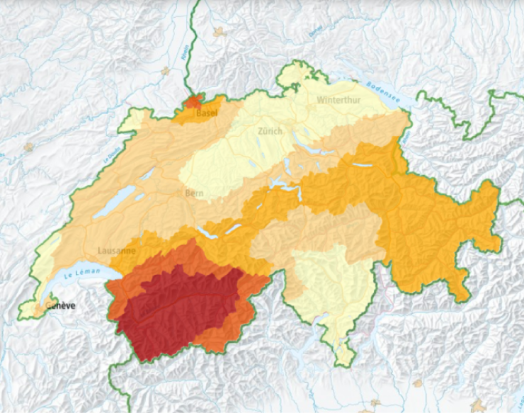
Structures designed to be earthquake-resistant provide the best protection from the effects of an earthquake. The specifications for such structures in Switzerland are laid down in SIA 261: Actions on Structures, a standard produced by the Swiss Society of Engineers and Architects (SIA). A revised version recently came into force, taking into account new data from the seismic hazard model updated in 2015 by the Swiss Seismological Service (SED) at ETH Zurich. The main adjustments relate to the map of earthquake zones and the response spectra for various subsoil categories. In order to better protect buildings with vital infrastructure functions (building class III, e.g. acute care hospitals), the safety factors required to prove the structural safety and serviceability of these buildings have also been increased slightly.
Based on a more fine-grained seismic hazard map, the earthquake zone map now divides Switzerland into five areas, each with differing requirements when it comes to earthquake-resistant construction. This is one more zone than before. The zone boundaries have also been adjusted based on the new findings from the updated seismic hazard model.
Read more...Engineers use response spectra to work out the design requirements for structures on various substrates (which are divided into subsoil categories for the purpose of the standards). Based on these response spectra, they identify the measures that need to be implemented to ensure that a structure built on the subsoil at a given location complies with the standards. The adjustments made to the response spectra in the revised standard are based on an in-depth analysis of earthquake recordings at many seismic stations together with geophysical measurements determining the local properties of the subsoil at the station locations. The standard takes account of the fact that loosely deposited sediments amplify the seismic waves. As a result, structures at such locations must be designed to withstand stronger ground movements.
In Switzerland, cantons are responsible for checking compliance with construction standards. In some cantons, building legislation explicitly requires compliance with the applicable SIA standards or lays down earthquake-specific requirements as part of the planning permission process. In others, implementation is not explicitly regulated by law and is not monitored either. According to the Swiss Federal Office for the Environment, the additional costs involved in making a structure earthquake-resistant represent no more than 1% of the total, provided that this is factored into the design at an early stage.
Learn more
Earthquake-Resistant Construction
SIA 261 (in German, French and Italian)
2020-08-20
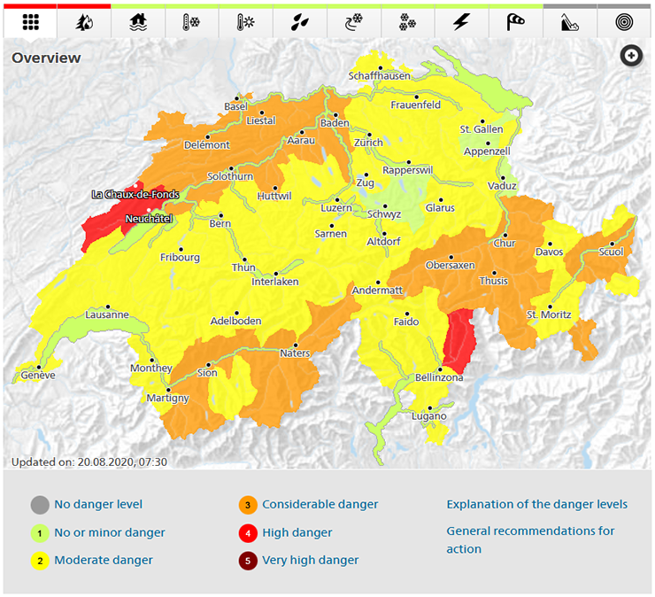
A new-look Natural Hazards Portal to keep Switzerland informed
Earthquakes are not the only natural hazard that Switzerland needs to really focus on. The country's topography and geography mean that it is prone to a variety of major natural hazards. The public must be warned in good time of storms sweeping across Switzerland, forest fires, or avalanches thundering down mountain slopes. They must also receive alerts about earthquakes as quickly as possible. Notifying the public of these events is the task of the federal agencies responsible for monitoring natural hazards. They provide up-to-date information on such hazards via the Natural Hazards Portal at www.natural-hazards.ch. These agencies have made various adjustments and improvements to this site to create a new-look portal, which is now being released.
Read more...Time and again, Switzerland is faced with natural events that have the potential to endanger human life and infrastructure. In light of this, the federal agencies responsible for monitoring natural hazards have joined forces to ensure that the public is adequately informed, warned and protected in such critical situations. They publish warnings about storms, heavy precipitation and snowfall, slippery roads, ground frost, heat waves, thunderstorms, forest fires, floods and avalanches, and issue alerts regarding current earthquakes.
The agencies jointly operate the Natural Hazards Portal with the aim of reaching as many people as possible when a natural event occurs and providing them with standardised information. Furthermore, they publish all warnings and alerts about natural hazards on this website and also issue these warnings and alerts through the MeteoSwiss app. As a result, reliable and consolidated information on current natural hazards situations and events is available to the public.
Following a revamp, a new-look Natural Hazards Portal is now being released. The updated portal features adjustments to how hazards are shown and illustrations depicting recommended behaviours. For example, rivers and lakes of national interest are now colour-coded based on their warning status, making this easier to see, while forest-fire risk is now shown along cantonal borders, with pictograms on key recommended behaviours making this information more user-friendly.
The federal agencies responsible for monitoring natural hazards firmly believe that these adjustments will help the Swiss public to locate the relevant information more easily and understand it more readily, both before and during natural hazards events.
The Federal Office for the Environment (FOEN), the Federal Office of Meteorology and Climatology (MeteoSwiss), the WSL Institute for Snow and Avalanche Research (SLF), the Swiss Seismological Service (SED) at ETH Zurich and the Federal Office for Civil Protection (FOCP) are officially mandated by the federal government to provide information and issue warnings to the public, the media and the authorities about impending natural hazards. In critical situations, the natural hazard agencies work particularly closely together, coordinating their forecasts and warnings and compiling joint press releases and bulletins about natural hazards.
You can find further information at www.natural-hazards.ch.
This text was adapted, with permission, from a MeteoSwiss blog entry (German).
2020-08-13
[Available in DE / FR] Erdbeben bei Zermatt
Am Mittwoch, dem 12. August 2020, hat sich um 23:15 Uhr Ortszeit ca. 3 km westlich von Zermatt (VS), in einer geringen Tiefe von ungefähr 3 km, ein Erdbeben der Magnitude 3.0 ereignet.
Die Erschütterung war fast ausschliesslich im nahen Epizentralgebiet, also vor allem in Zermatt selbst, gut zu spüren. Die am Schweizerischen Erdbebendienst der ETH Zürich eingegangenen Meldungen berichten von einer kurzen, nicht besonders angsteinflössenden Vibration. Bei einem Erdbeben dieser Stärke sind in der Regel keine Schäden zu erwarten.
Das Wallis ist das Gebiet der Schweiz mit der stärksten Erdbebengefährdung, im Wallis selbst gehören Saastal und Mattertal aber nicht zu den exponiertesten Zonen. Das letzte verspürte Beben im Gebiet ereignete sich am 21.7.2018 10 km östlich von Zermatt. Es hatte eine Magnitude von 2.6.
![[Available in DE / FR] Erdbeben bei Zermatt [Available in DE / FR] Erdbeben bei Zermatt](/export/sites/sedsite/home/.galleries/img_news_2020/Zermatt_d.png_2063069299.png)
2020-07-11
[Available in DE / IT] Beben zwischen Locarno und Bellinzona
Am Samstag, 11. Juli 2020, ereignete sich um 13:53 Uhr Ortszeit ein Erdbeben nördlich der Magadinoebene zwischen Locarno und Bellinzona (TI) mit einer Magnitude 2.9 und einer Tiefe von ca. 14 km.
Das Erdbeben wurde weiträumig verspürt, insbesondere in Bellinzona und Giubiasco. Beim SED gingen in der Stunde nach dem Beben über 80 Verspürtmeldungen ein. Bei einem Erdbeben dieser Stärke sind keine Schäden zu erwarten.
Obschon seismisch weniger aktiv als zum Beispiel das Wallis, kann es auch im Bergkanton Tessin gelegentlich zu Erdbeben kommen. Das letzte verspürte Beben in der Region war am 1. Mai 2010 mit einer Magnitude von 2.6 bei Lodrino.
![[Available in DE / IT] Beben zwischen Locarno und Bellinzona [Available in DE / IT] Beben zwischen Locarno und Bellinzona](/export/sites/sedsite/home/.galleries/img_news_2020/map_de.png_2063069299.png)
2020-05-28
[Available in DE / FR] Weiterhin aktive Erdbebensequenz im Glarnerland
Seit Dienstag, dem 26. Mai 2020, ist im Sernftal (westlich von Elm GL) eine Erdbebensequenz aktiv. Sie begann um 07:50 Uhr Ortszeit mit einem Beben der Magnitude 3.1 (siehe vorangegangener Beitrag). Seitdem und bis am Mittag des 28. Mai 2020 konnten mit dem Messnetz des Schweizerischen Erdbebendienstes an der ETH Zürich (SED) 13 weitere Beben mit hoher Qualität lokalisiert werden. Die beiden stärksten Beben hatten Magnituden von 2.9 und 2.8 und wurden jeweils am Mittwoch, um 02:55 Uhr und 09:11 Uhr, nahe beim Epizentrum schwach verspürt.
Die Grafik oben zeigt, wie sich die Bebenaktivität über die Zeit entwickelt hat. Die Abbildung umfasst einerseits die 22 lokalisierten Beben (rot umrandet; darunter neun Beben geringerer Lokalisierungsqualität, die nicht im Erdbebenkatalog erscheinen). Anderseits sind weitere, sehr kleine Ereignisse abgebildet. Diese konnten nachträglich durch einen systematischen Vergleich der Wellenformen ermittelt werden; jene der kleinen Beben weisen ähnliche Muster auf wie die der standardmässig aufgezeichneten. Die dazu angewendete Methode des «template-matching» wird derzeit am SED erforscht und weiterentwickelt. Sie ermöglicht, solche Sequenzen noch besser zu verstehen.
Read more...In vorherigen Beitrag wurde bereits auf die Nähe zum Urnerboden Erdbebenschwarm von 2017 hingewiesen. In etwas kleinerer Entfernung ereignete sich 10 km westlich der aktuellen Beben am 17. März 2001 ein Beben der Magnitude 3.8 bei Linthal (GL). Im Gebiet der aktuellen Sequenz registrierte der SED bereits im Sommer 1987 eine ähnliche Erdbebenserie von damals 34 Erdbeben, die über einen Monat dauerte. Das stärkste Beben hatte eine Magnitude von 2.4. Eine Relativlokalisierung der Erdbeben zueinander zeigte, dass sie alle entlang einer fast senkrechten Störung auftraten, die Ost-West orientiert ist. Die Bewegung ist dabei dextral: Das heisst, dass egal auf welcher Seite der Verwerfung man sich befindet, die gegenüberliegende Seite sich nach rechts bewegt.
Erste vorläufige Untersuchungen der bisher aufgezeichneten Beben scheinen die fast gleiche Verwerfungsgeometrie für die jetzige Sequenz zu zeigen. Das deutet darauf hin, dass aktuell das selbe Verwerfungssystem wie 1987 reaktiviert wurde. In diesem Teil der Alpen sind aus der Oberflächengeologie sowohl solche Ost-West streichende Störungen bekannt, wie auch Nord-Süd streichende. Wie schon in der Sequenz von 1987 deuten vorläufige Analysen darauf hin, dass die aktuellen Beben relativ oberflächennah auftreten. Mit einer Tiefe von ca. 2 km liegen sie wahrscheinlich im Kontaktbereich zwischen Sedimentüberdeckung und kristallinem Grundgebirge. Aufgrund bestehender Unsicherheiten in der Tiefenbestimmung ist eine genauere Einschränkung derzeit noch nicht möglich.
Obwohl sich die seismische Aktivität in den letzten 24 Stunden verringert hat, ist es schwierig, eine Prognose über die Erdbebenaktivität in den nächsten Tagen und Wochen zu machen. Solche Schwärme können erfahrungsgemäss sehr unterschiedlich verlaufen. Es ist aber immer noch möglich – wenn auch wenig wahrscheinlich – dass weitere, noch stärkere Beben auftreten werden. Allgemein kann daran erinnert werden, dass grössere Erdbeben mit einer Magnitude von 6 oder mehr zwar selten sind, in der Schweiz aber überall und jederzeit auftreten können. Im Durchschnitt ist in der Schweiz alle 50 bis 150 Jahre mit einem Erdbeben mit einer Magnitude von etwa 6 zu rechnen.
2020-05-19
[Available in DE / FR] Erdbeben bei Sion
Am Dienstag, den 19. Mai 2020, ereignete sich um 08:10 Uhr Ortszeit ein Erdbeben der Magnitude 2.1 im Rhonetal, östlich von Sion (VS). Die Tiefe des Bebens lag in ungefähr 6 km. Trotz seiner relativ geringen Magnitude wurde das flache Erdbeben von zahlreichen Personen verspürt: Innerhalb von rund zwei Stunden nach dem Beben gingen beim Schweizerischen Erdbebendiest rund 80 Verspürtmeldungen ein, die meisten davon in Sion selbst und alle in einem Umkreis von nur 10 km. Das Rhonetal ist eine Region mit einer der grössten Erdbebengefährdungen in der Schweiz.
![[Available in DE / FR] Erdbeben bei Sion [Available in DE / FR] Erdbeben bei Sion](/export/sites/sedsite/home/.galleries/img_news_2020/20200519_Sion.png_2063069299.png)
2020-04-07
[Available in DE / FR] Geothermieprojekt Haute-Sorne – Kanton erwägt Genehmigung zurückzuziehen
In der jurassischen Gemeinde Haute-Sorne war vorgesehen, ein petrothermales Tiefengeothermieprojekt zur Stromerzeugung zu errichten. Die Frage nach dem mit dem Projekt verbundenen seismischen Risiko wurde vom Kanton erneut aufgeworfen, nachdem sich im November 2017 nahe der südkoreanisches Stadt Pohang ein Erdbeben mit einer Magnitude von 5.5 ereignet hat (siehe Aktuellbeitrag vom 24.05.2019 für eine Übersicht). Auslöser des Bebens war ein petrothermales Tiefengeothermieprojekt in unmittelbarer Nähe. Die Geo-Energie Suisse AG (GES), welche das Projekt in Haute-Sorne plant und betreiben möchte, wurde daraufhin von Kanton Jura aufgefordert, ihre Risikobeurteilung im Lichte der Erkenntnisse aus Südkorea neu zu bewerten. Anschliessend erhielt der Schweizerische Erdbebendienst (SED) an der ETH Zürich vom Kanton das Mandat, die aktualisierte Risikobeurteilung der GES zu prüfen.
Am 6. April 2020 hat der Kanton Jura den Bericht des SED veröffentlicht und seinen Entscheid für das weitere Vorgehen bekannt gegeben: Er erwägt, die Genehmigung für das Tiefengeothermieprojekt in Haute-Sorne zurückzuziehen. Alle Informationen sind auf folgender Seite publiziert: https://www.jura.ch/CHA/SIC/Centre-medias/Communiques-2020/Le-Gouvernement-envisage-de-revoquer-l-arrete-d-approbation-du-plan-special-cantonal-Projet-pilote-de-geothermie-profonde-a-Ha.html#
![[Available in DE / FR] Geothermieprojekt Haute-Sorne – Kanton erwägt Genehmigung zurückzuziehen [Available in DE / FR] Geothermieprojekt Haute-Sorne – Kanton erwägt Genehmigung zurückzuziehen](/export/sites/sedsite/home/.galleries/img_news_2020/Haute-Sorne_web.png_2063069299.png)
2020-02-24
The seismicity of Mars
Fifteen months after the successful landing of the NASA InSight mission on Mars, first scientific analyses of ETH Zurich researchers and their partners reveal that the planet is seismically active. The recorded data enables a better understanding of the interior of Mars, the primary goal of the InSight mission.
On 26 November 2018, the NASA InSight lander successfully set down on Mars in the Elysium Planitia region. Seventy Martian days later, the mission’s seismometer SEIS began recording the planet’s vibrations. A team of researchers and engineers at ETH Zurich, led by ETH Professor Domenico Giardini, had delivered the SEIS control electronics and is responsible for the Marsquake Service. With the first data coming in, the Marsquake Service, operated by researchers of the Swiss Seismological Service in collaboration with the seismology and geodynamics group at ETH Zurich and international colleagues, commenced full operation. On a daily basis, incoming data is analyzed and interpreted. However, only a fraction of the data is automatically sent to Earth due to transmission limitations. As soon as the marsquake service team spots distinctive features, they request the full-rate data for this period and scrutinize it upon arrival. Now, the journal Nature Geoscience published a series of articles on the results of the mission in the first months of operation on Mars.
Read more...As reported in these articles, InSight recorded 174 events until the end of September 2019. Since then, the measurements have continued leading to more than 450 observed marsquakes as of today, which have not yet been analysed in detail. This accounts for one event a day on average. The data allows researchers observing how seismic waves travel through the planet and unveiling its internal characteristics – similar to how x-rays are used in medical tomography. Before InSight landed, researchers had developed a wide range of possible models to represent the internal structure of the red planet. The recorded marsquakes, already after few months, enable refining the understanding of the structure of the planet and to reduce the uncertainties.
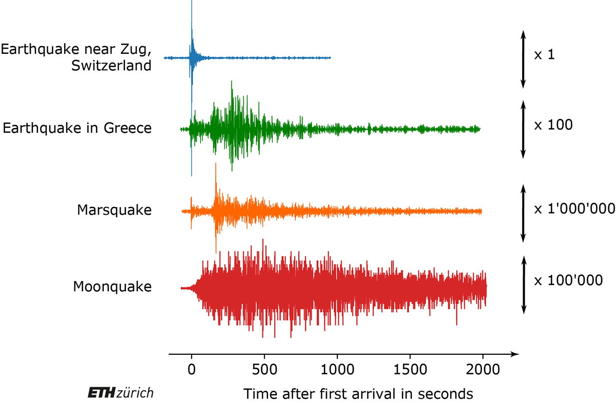
Marsquakes are similar to the seismic events we see on Earth, although they are generally of smaller magnitude. The 174 registered marsquakes can be categorized into two families: One includes 24 low-frequency events with magnitudes between 3 and 4, as documented in the papers, with waves propagating through the Martian mantle. A second family of marsquakes comprises 150 events with smaller magnitudes, shallower hypocentral depth and high frequency waves trapped in the Martian crust. “Marsquakes have characteristics already observed on the Moon during the Apollo era, with a long signal duration (10 to 20 minutes) due to the scattering properties of the Martian crust”, explains ETH Professor Giardini. In general, however, he says, interpreting marsquake data is very challenging and in most cases, it is only possible to identify the distance but not the direction from which the waves are arriving.
InSight opens a new era for planetary seismology. The SEIS performance exceeded so far expectations, considering the harsh conditions on Mars, characterized by temperatures ranging from minus 80 to 0 degrees Celsius every day and by strong wind oscillations. Indeed wind shakes the InSight lander and its instrumentation during the day leading to a high level of ambient noise. However, at sunset, the winds calm down allowing recording the quietest seismic data ever collected in the solar system. As a result, most seismic events detected on Mars by SEIS occurred in the quiet night hours. The challenging environment also requires to carefully distinguishing between seismic events and signals originating from movements of the lander, other instruments or atmospheric-induced perturbances.
The hammering by the HP3 instrument (another InSight experiment) and the close passage of whirlwinds (dust devils), recorded by SEIS, allow to map the physical properties of the shallow soil layers just below the station. We now know that SEIS landed on a thin, sandy layer reaching a few meters deep, in the middle of a 20 meter-wide ancient impact crater. At greater depths, the Martian crust has properties comparable to Earth’s crystalline massifs but appears to be more fractured. The propagation of the seismic waves suggest that the upper mantle has a stronger attenuation compared to the lower mantle.
InSight landed in a rather quiet region of Mars, as no events near the station have been recorded up to now. The three biggest events were located in the Cerberus Fossae region about 1’500 km away. It is a tectonic graben system, caused by the weight of the Elysium Mons, the biggest volcano in the Elysium Planitia area. This provides strong evidence that seismic activity on Mars is not only a consequence of the cooling and therewith the shrinking of the planet but also induced by tectonic stress. The total seismic energy released on Mars lies between the one of Earth and of the Moon.
SEIS, complementary to other InSight measurements, also meaningfully contributed data to better understand the meteorological processes on Mars. The instrument’s sensitivity to both wind and atmospheric pressure allowed identifying meteorological phenomena characteristic of Mars, including the many dust devils that pass by the spacecraft every afternoon.
More detailed results of the seismic analysis and additional findings of the InSight mission can be accessed in the series of papers recently published in Nature Geosciences: The seismicity of Mars, Crustal and time-varying magnetic fields at the InSight landing site on Mars, The atmosphere of Mars as observed by InSight, Initial results from the InSight mission on Mars.
Learn more about the NASA InSight mission: https://mars.nasa.gov/insight/ and about ETH Zurich’s involvement in InSight: www.insight.ethz.ch
2020-01-25
[Available in DE / FR] Erdbeben im Turtmanntal (VS)
Am Samstag, den 25. Januar 2020, ereignete sich um 20:13 Uhr (Ortszeit) ein Erdbeben der Magnitude 3.0 in einer Tiefe von ca. 4 km unterhalb des Turmanntals (VS) zwischen dem Val d’Anniviers und dem Mattertal.
Das Erdbeben wurde weiträumig verspürt, insbesondere im Rhonetal und Mattertal. Beim SED gingen in der Stunde nach dem Beben über 100 Verspürtmeldungen ein. Bei einem Erdbeben dieser Stärke sind keine Schäden zu erwarten.
Kurz zuvor, um 20:07 (Ortszeit), ereignete sich westlich von Realp (UR) ein Beben mit einer Magnitude von 2.4 bei einer Tiefe von rund 9 km, welches jedoch kaum verspürt wurde. Zwischen diesen beiden Beben gibt es keinen direkten Zusammenhang.
![[Available in DE / FR] Erdbeben im Turtmanntal (VS) [Available in DE / FR] Erdbeben im Turtmanntal (VS)](/export/sites/sedsite/home/.galleries/img_news_2020/map_DE.png_2063069299.png)
2020-07-24
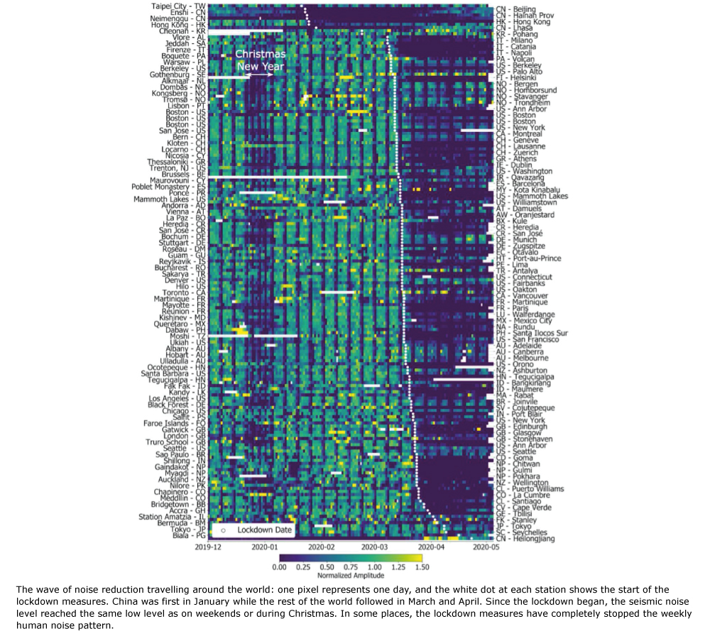
COVID-19 pandemic reduces seismic noise worldwide
Research recently published in the journal Science has shown that lockdown measures to combat the spread of COVID-19 lead to a 50% reduction in seismic noise observed around the world in early to mid-2020. In Switzerland, researchers from the Swiss Seismological Service (SED) at ETH Zurich were also able to identify this phenomenon, as the SED announced in an earlier news item in April 2020. The SED, therefore, participated in the international study, in which a total of 76 authors from 66 institutions in 27 countries collaborated.
Read more...By analysing month-to-years long datasets from over 300 seismic stations around the world, the study, led by Dr Thomas Lecocq from the Royal Observatory of Belgium, was able to show how the seismic noise decreased in many countries and regions since the start of the lockdown measures. The researchers could visualise the resulting "wave of quiet” moving through China, then to Italy, and around the rest of the world. The seismic lockdown sees the total effect of physical and social distancing measures, reduced economic and industrial activity and drops in tourism and travel. The 2020 seismic noise quiet period is the longest and most prominent global anthropogenic seismic noise reduction on record.
Traditionally, seismology focuses on measuring and analysing seismic waves arising from earthquakes. High-frequency vibrations (“buzz”) of human activity, however, contaminate the seismic records from natural sources. Walking around, driving cars, and getting the train, but also heavy industry and construction work generate unique seismic signals in the subsurface that influence the recordings of natural phenomena. The strongest seismic noise reductions from the COVID-19 lockdown were found in urban areas, but the study also observed signs of the lockdown on sensors installed hundreds of meters below the surface and in more remote areas, such as in sub-Saharan Africa. Furthermore, the researchers found a strong correlation between seismic noise reduction and human mobility datasets.
In Switzerland, in particular the stations belonging to the Swiss Strong Motion Network (SSMNet) did show similar effects. Many of these measuring stations are located in urban areas and a significant reduction in seismic noise was recorded in Lugano, Martigny, Zurich, Basel and Geneva, among others. Since the lockdown was declared in mid-March, levels of seismic noise in these towns and cities have been nearly as low on working days as they were during weekends before the lockdown began. Meanwhile, the seismic noise is back to almost normal levels in Switzerland and in most countries analysed in the study.
Will the 2020 seismic noise quiet period allow new types of signals to be detected? The study has shown the first evidence that previously concealed earthquake signals, especially during the daytime, appeared much clearer on seismic sensors in urban areas during the lockdown. In Switzerland, the overall effect is a decrease in the detection threshold for earthquakes by about 0.1 - 0.2 magnitude units across the country, for many urban areas this decrease is even greater at 0.3 magnitude units or more.
SED seismologist Dr Frédérick Massin, one of the co-authors of the study, says that the researchers hope that their work will spawn further research on the seismic lockdown. Finding previously hidden signals from earthquakes and volcanoes will be one key goal. Due to the growing urbanisation and increasing populations, it becomes more important than ever to characterise the anthropogenic noise humans cause so that seismologists can better listen to the Earth, especially in cities, and monitor the ground movements beneath our feet.
More information: https://science.sciencemag.org/lookup/doi/10.1126/science.abd2438
2020-06-23
[Available in DE / FR] Beben bei Vallorcine (F)
Am Dienstag, 23. Juni 2020, ereignete sich um 08:25 Uhr (Ortszeit) ein Erdbeben bei Vallorcine (F) nahe der Schweizer Grenze mit einer Magnitude 3.8 und einer Tiefe von ca. 5 km.
Das Erdbeben wurde weiträumig verspürt, insbesondere im Rhonetal, von Sitten bis zum Genfersee. Beim SED gingen in der Stunde nach dem Beben über 250 Verspürtmeldungen ein. Bei einem Erdbeben dieser Stärke sind keine Schäden zu erwarten.
In der Region von Vallorcine kommt es seit einem Beben mit einer Magnitude von 4.9 am 8. September 2005 immer wieder zu kleineren Beben. Etwa 15 davon waren stark genug, um von der lokalen Bevölkerung verspürt zu werden.
![[Available in DE / FR] Beben bei Vallorcine (F) [Available in DE / FR] Beben bei Vallorcine (F)](/export/sites/sedsite/home/.galleries/img_news_2020/20200623_map_de.png_2063069299.png)
2020-05-26
[Available in DE / FR] Beben in den Glarner Alpen
Am Dienstag, dem 26. Mai 2020, hat sich um 07:50 Uhr Ortszeit etwa 3 km westlich von Elm (GL), im Sernftal, in einer Tiefe von ungefähr 4 km ein Erdbeben der Magnitude 3.1 ereignet. Bei einem Erdbeben dieser Stärke sind in der Regel keine Schäden zu erwarten.
Die Erschütterungen wurden in der Nähe des Epizentrums teilweise deutlich wahrgenommen. Am Schweizerischen Erdbebendienst der ETH Zürich gingen aber fast keine Verspürtmeldungen aus Entfernungen über 20 km ein.
In den vergangenen Jahren haben sich in diesem Gebiet vereinzelt spürbare Beben ereignet. Am 6. März 2017 erschütterte ein Beben der Magnitude 4.6 die ganze Innerschweiz. Sein Epizentrum lag aber 15 km weiter westlich, bei Urnerboden. Ebenso wie das heutige Beben ereignete sich auch das Urnerboden Beben in etwa 4 km Tiefe. Erdbeben in diesem Teil der Alpen liegen meistens weniger als 5 km tief, und damit relativ nah an der Oberfläche.
![[Available in DE / FR] Beben in den Glarner Alpen [Available in DE / FR] Beben in den Glarner Alpen](/export/sites/sedsite/home/.galleries/img_news_2020/Elm_d.png_2063069299.png)
2020-04-29
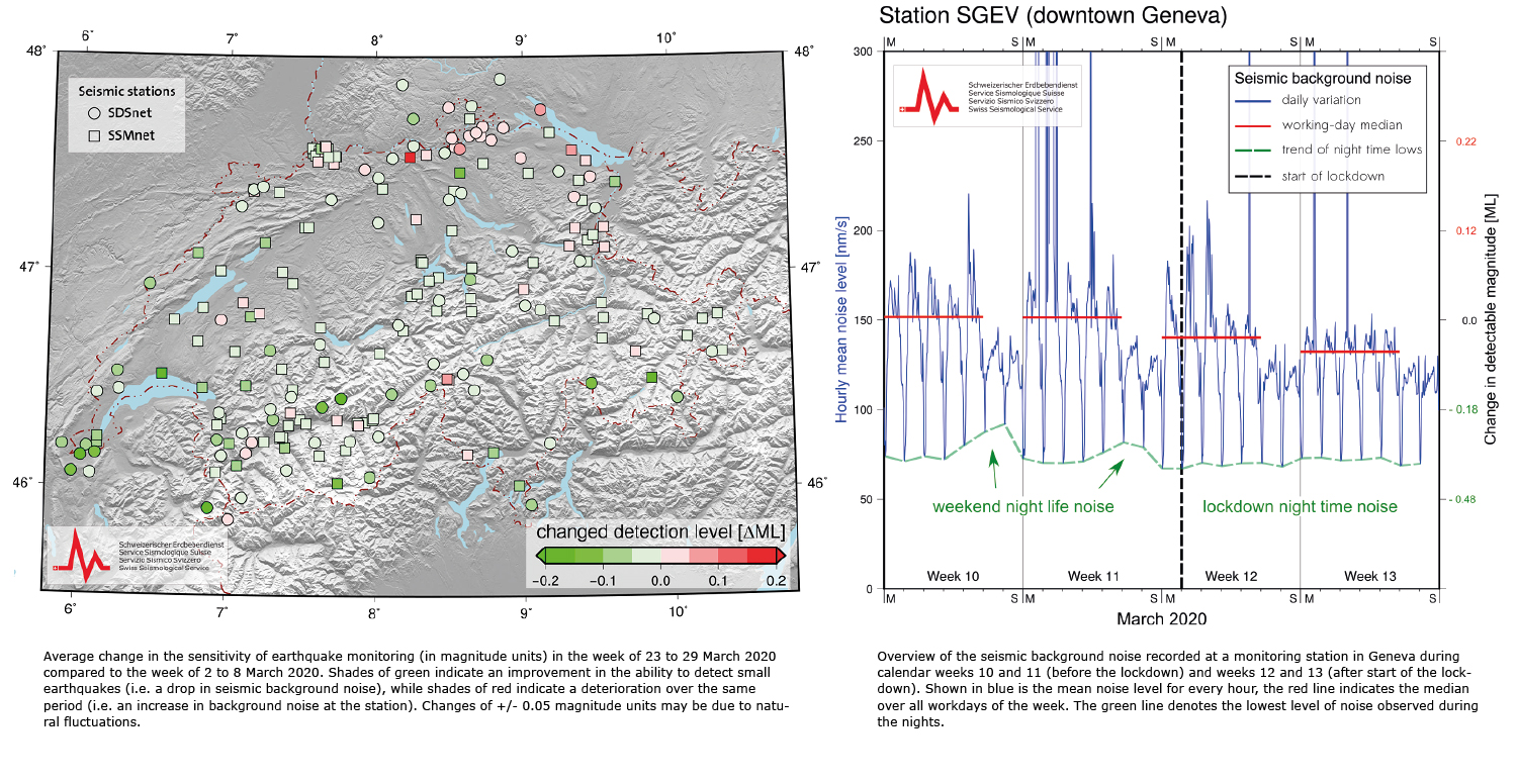
Measures to combat COVID-19 also reducing seismic noise in Switzerland
Seismic measuring stations do not only record seismic waves. They also pick up tremors caused by other factors: these are known as seismic background noise. Humans are partly responsible for these constant movements of the Earth. For instance, road traffic or industrial activities may cause vibrations in the Earth’s crust. Their impact is typically greater during the day and lower at night and at the weekend. Wind, waves and the weather also cause the Earth to vibrate constantly. International studies have shown that levels of human-induced seismic background noise have decreased in many locations since the outbreak of the coronavirus pandemic. Measuring stations are thus indirectly detecting the effects of the lockdown and the associated drop in human activity. The Swiss Seismological Service at ETH Zurich has observed this phenomenon in Switzerland too.
Some of the stations belonging to the Swiss Strong Motion Network (SSMNet) in particular, many of which are located in urban areas, have recorded significant drops in seismic background noise. This has been the case for the stations in Martigny, Zurich, Basel and Geneva, among others. Since the state of emergency was declared, levels of background noise in these towns and cities have been almost as low on working days as they were at weekends before the lockdown began. Saturday and Sunday evenings have also been far quieter than usual since the start of the lockdown. The seismic noise levels recorded on weekend evenings have fallen to the level typically observed on a normal weekday evening in the relevant towns and cities – as a rule, more seismic noise is generated on weekend evenings than on weekday evenings.
Read more...Conversely, rural or alpine stations belonging to the national broadband network (SDSNet) have only recorded slight decreases in background noise because these areas are considerably less affected by vibrations from road traffic, trains and other human activities. Strong winds and other weather factors may nevertheless lead to increased levels of background noise in some areas, as may have been the case in northeastern Switzerland during the period under study (23 to 29 March 2020).
Due to the exceptional situation in Switzerland, measuring stations are now able to detect somewhat smaller earthquakes whose signals would otherwise be lost amid the background noise. The COVID-19 lockdown has therefore increased the sensitivity of earthquake monitoring in some parts of Switzerland, although the overall effect, at just 0.1 to 0.2 magnitude units, is not very great. By way of comparison, the sensitivity of monitoring is on average 0.5 magnitude units greater during the night than during daytime working hours. Latest data show at some stations that the seismic background noise has slightly increased over the last days. However, statements about compliance with lockdown measures cannot be derived from these data.
2020-03-18
[Available in DE] Erdbeben bei Vevey
Am Mittwoch, den 18. März 2020, ereignete sich um 02:54 Uhr Ortszeit ein Erdbeben der Magnitude 2.6 rund 10 km östlich von Vevey (VD). Die Tiefe des Bebens lag in ungefähr 9 km.
Das Epizentrum lag in der Gemeinde Montbovon (FR). Zahlreiche Personen in der Region haben das Beben verspürt.
Innerhalb des letzten Jahres gab es in der östlichen Genferseeregion mehrere, meist schwächere Erdbeben. Das stärkste Erdbeben des vergangenen Jahres in dieser Region ereignete sich am 28.05.2019 rund 13 km südwestlich von Vevey mit einer Magnitude von 4.2.
![[Available in DE] Erdbeben bei Vevey [Available in DE] Erdbeben bei Vevey](/export/sites/sedsite/home/.galleries/img_news_2020/20200317_map_de.png_2063069299.png)
2020-02-17
LabQuake: taking lab scale studies of earthquakes to the next level
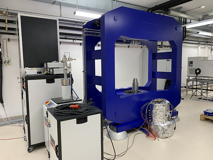
In the beginning of February, the Swiss Seismological Service (SED) at ETH Zurich received a very special delivery: An 11-ton and 2.4 x 2.5 x 1 meters machine that can induce small earthquakes in palm-sized rock samples under conditions that are representative for the Earth’s crust in 4–8 km depth. This apparatus is called LabQuake and has been installed in the Rock Physics and Mechanics Laboratory under the responsibility of Dr. Claudio Madonna. LabQuake will enable a new research direction for the SED – Laboratory Seismology – aimed at gaining a better understanding of earthquake physics, for example in the context of induced earthquakes triggered by deep geothermal stimulations. Dr. Paul Selvadurai is leading the newly created Laboratory Seismology research group.
To develop a better understanding of nature, scientist often examine complex problems in the laboratory where they control the environment, repeat experiments and place dense arrays of sensors. With LabQuake, scientists induce tens of thousands of very small earthquakes – so-called nano-seismic events that produce the same order of energy as an insect flapping its wings once – in rock samples and observe how they form, what controls them, and why they cease. To this end, LabQuake is equipped with various sensors, measuring in great detail the evolution of nano-seismicity, strain and pore-pressure within the rock sample.
Read more...Unique in the world
LabQuake exposes rock samples of a maximum size of 7.6 cm to conditions at which deep geothermal energy plants operate: temperatures of up to 170° Celsius and a confining pressure of 170 MPa, which corresponds approximately to 1678 atmospheres or a 17.3 km high water column. The maximum force that the scientists can apply to the rock samples equals to the weight of 125 mid-size SUVs (about 2500 kN).
One of the first applications of LabQuake will be to repeat experiments on rock samples collected in underground research labs. LabQuake ideally supplements experiments at the deca-meter scale performed in the Grimsel In-situ Stimulation and Circulation (ISC) project. Scientists test hypotheses from this project and downscale them to LabQuake. Afterwards, they upscale the new findings and apply them to field scale experiments that are conducted within the Bedretto Laboratory for Geoenergies. Hence, LabQuake bridges the gap between projects at different scales and contributes to improve their accuracy and their performance.
The finances for LabQuake amount to roughly 1.2 million Swiss Francs and were secured through the start-up fund of the Professorship Wiemer, with contributions from the SNF R-equipment programme, the ETH equipment programme and the department of Earth Sciences.
To see how LabQuake was delivered to the SED, watch the time-lapse video here.
2020-01-14
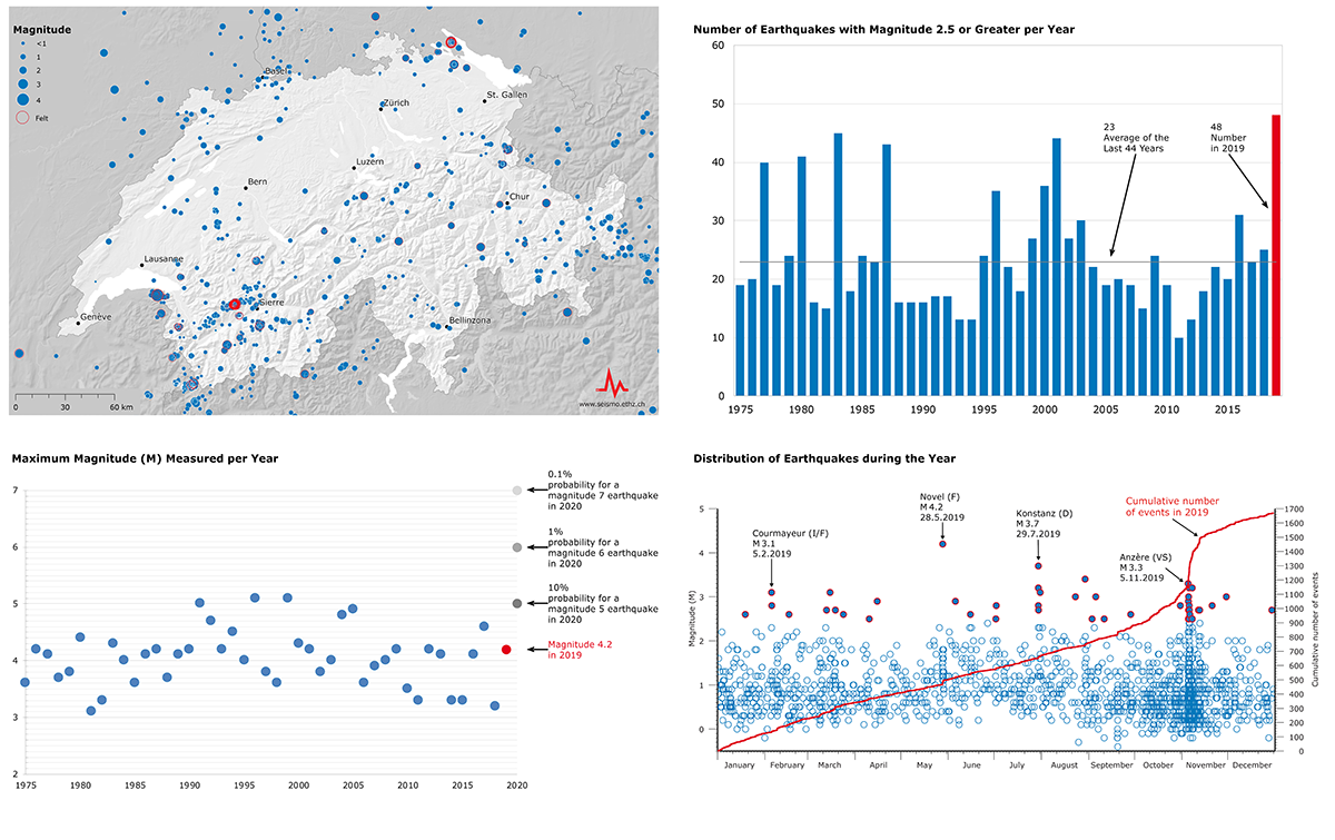
Earthquakes in Switzerland in 2019
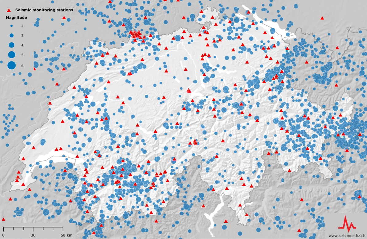
Last year, twice as many earthquakes occurred in Switzerland and in neighbouring countries compared to the long-term average. For nearly 50 of the total of 1,670 recorded earthquakes, the Swiss Seismological Service (SED) at ETH Zurich received five or more felt reports. Most of the quakes can be attributed to five active earthquake sequences that shaped seismic activity in 2019. One of them was in the canton of Valais, in the area between Anzère and the Sanetsch Pass. The other four occurred just over the Swiss border, at Courmayeur (Italy), Novel (France), Konstanz (Germany) and Chamonix (France).
In Switzerland, earthquakes often occur in sequences referred to as 'earthquake swarms', i.e. clusters of tremors occurring over time at one, specific location. An unusual feature of last year's seismic activity was the number of highly active earthquake sequences leading to a never previously recorded amount of events since modern seismic monitoring began in the 1970s. This also resulted in more felt earthquakes than usual. As a rule, quakes felt by humans have usually a magnitude of 2.5 or more. The last time a similar cluster of felt quakes occurred was back in 1964, when Sarnen, in the canton of Obwalden, experienced a distinct sequence of earthquakes over a period of several months, with magnitudes of up to 5.3. Although such a high level of earthquake activity as that experienced in 2019 is rare, it is neither unexpected, nor a sign of an increased seismic hazard over the months and years to come.
Read more...An earthquake swarm comprising 16 quakes in the canton of Valais prompted some 2,000 reports by members of the public who had felt them, the highest level of public attention gained all year. During the first half of November, more than 300 quakes occurred north of Sion, between Anzère and the Sanetsch Pass. The two largest events had a magnitude of 3.3. Initial analyses suggest that during this sequence several simultaneously activated faults influenced each other. By contrast, the seismic activity on the Bodanrück peninsula near Konstanz (Germany) appears to have been associated with a single activated structure in the geological underground. All the quakes there share a similar rupture mechanism. This swarm, comprising a total of seven felt earthquakes, indicates a seismically active fault structure in the Hegau-Bodensee region.
The largest earthquake in 2019, with a magnitude of 4.2, occurred at the end of May as part of the earthquake swarm near Novel (France). The SED received 600 felt reports for this event alone. The second strongest quake, with a magnitude of 3.7, occurred in connection with the swarm near Konstanz (Germany). The largest cluster of events in 2019 (410 quakes in all) was associated with the long-standing active sequence near Courmayeur (Italy) in the area of the Mont Blanc massif.
The overall total of 1,670 recorded earthquakes is a new record. But this high number is not only due to the high level of earthquake activity in the past year, but can also be attributed to the steady densification and modernisation of the seismic network. For seismologists, it is helpful for more earthquakes to be recorded, because such measurements enable them to produce an ever more detailed picture of the Alps' geological underground and seismotectonics. Among other things, this can help to improve the basis for future seismic hazard and risk assessments.


![[Available in DE, IT] Im Tessin verspürtes Beben bei Mailand [Available in DE, IT] Im Tessin verspürtes Beben bei Mailand](/export/sites/sedsite/home/.galleries/img_news_2020/Mailand.PNG_2063069299.png)
![[Available in DE, FR] Erneutes weiträumig verspürtes Erdbeben bei Elm (GL) [Available in DE, FR] Erneutes weiträumig verspürtes Erdbeben bei Elm (GL)](/export/sites/sedsite/home/.galleries/img_news_2020/20201110_beben_4_1200px.png_2063069299.png)
![[Available in DE / FR] Erdbebensequenz im Glarnerland erneut aktiv [Available in DE / FR] Erdbebensequenz im Glarnerland erneut aktiv](/export/sites/sedsite/home/.galleries/img_news_2020/20201026_elm.png_2063069299.png)
![[Available in DE / FR] Weiterhin aktive Erdbebensequenz im Glarnerland [Available in DE / FR] Weiterhin aktive Erdbebensequenz im Glarnerland](/export/sites/sedsite/home/.galleries/img_news_2020/Earthquake_series_Elm.png_2063069299.png)
