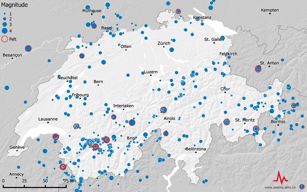
News Archive 2017
2017-12-20
Merry Christmas and a dynamic new year without strong shaking
Our Christmas tree is richly decorated this year. It has as many Christmas ornaments as the number of earthquakes that occurred in and around Switzerland from 1 January until 31 October 2017.
1047 earthquakes with magnitude below 2.5
17 earthquakes with magnitude between 2.5 and 3.9
2 earthquakes with magnitude above 3.9:
magnitude 4.6, Urnerboden (UR), 6 March
magnitude 4.3, Château-d’Oex (VD), 1 July
We wish you a Merry Christmas and a dynamic new year though hopefully without strong shaking!

2017-12-13
[Available in DE / FR] Leicht verspürtes Beben bei Sion
Am Dienstag, dem 12. Dezember 2017 hat sich um 23:28 Uhr (Lokalzeit) 10 km südöstlich von Sion (VS) in einer Tiefe von 6 bis 7 km ein Erdbeben der Stärke 2.1 ereignet.
Solch relativ schwache Erdbeben werden in der Regel nicht oder nur sehr vereinzelt verspürt, aber mehr als 45 Personen haben dieses Ereignis auf unserer Webseite gemeldet. Der Grund dafür liegt in einer Kombination von drei Faktoren: geringe Herdtiefe, Tageszeit (alles ist ruhig und viele sind noch wach) und bekannte Verstärkungseffekte der lockeren Rhonetal-Sedimente. So kamen auch die meisten Meldungen aus Bramois und Grône, zwei Gemeinden am südlichen Talrand.
Read more...Das Ereignis vom 12. Dezember sowie ein kleines Nachbeben der Stärke 1.0 sechs Stunden später gehören zu einem kleinen Schwarm von Beben, der etwa 6 km von der Rhone, talparallel orientiert ist. Die Beben stehen somit in keinem direkten Zusammenhang zu den Beben, die dieses Jahr schon verschiedentlich im Zentralwallis verspürt worden sind. Diese lagen nördlich der Talmitte (siehe Karte).
![[Available in DE / FR] Leicht verspürtes Beben bei Sion](/export/sites/sedsite/home/.galleries/img_news_2017/Wallis_1712.jpg_2063069299.jpg "[Available in DE / FR] Leicht verspürtes Beben bei Sion")
2017-11-24
What you need to know about earthquakes and deep geothermal energy
One major challenge for past and future deep geothermal power projects is how to produce a working heat exchanger with sufficient rock permeability without triggering damaging or felt earthquakes as a result. The problems associated with this challenge are varied and complex, such as how to distinguish between natural (tectonic) and man-made (induced) earthquakes. In purely physical terms, there is no difference between these types of quake. A distinction, albeit one that rarely leads to a conclusive classification, can only be drawn between them based on the earthquake's location, time of occurrence, focal mechanism and connection with any human activities.
Read more...Just how difficult such a classification can be is currently apparent in South Korea. On 15 November 2017, a shallow earthquake with a magnitude of 5.4 occurred near Pohang, a few kilometres away from a geothermal plant currently under construction. Since 2016, the subsurface has been repeatedly stimulated in two boreholes up to 4.3 km deep, with a view to subsequently forcing water through the rock to heat it up. The latest such stimulations took place in August and September 2017 and did not trigger any major earthquakes. Within the framework of Project DESTRESS, the Korean operators and authorities, flanked by international experts, are currently investigating a possible connection between the quake and the human interventions that have occurred.
Such a line of enquiry and the successful strategies (“good practices”) derived from it are dealt with in a scientific report commissioned by the Swiss Seismological Service (SED) at ETH Zurich. It has been accomplished as part of GEOBEST-CH, a project supported by EnergieSchweiz, which examines good practices for dealing with potential induced seismicity. The report is intended to provide useful tips, in particular for operators of geothermal power plants and the licensing authorities, on how to gauge and limit the risks of man-made earthquakes.
It starts off with an introduction to natural earthquake activity in Switzerland, some background information on induced seismicity and a summary of the lessons learnt during the failed geothermal projects in St. Gallen and Basel. Building on this, it then contemplates guidelines for the seismic monitoring of geothermal projects and presents recommendations for regulators and field operators on how to estimate seismic activity and the risks and hazards associated with it. The objective is to develop measures that take account of the need to protect people, the environment, goods and buildings as well as considering local geological conditions and plant design.
The Geothermal Risk of Induced seismicity Diagnosis grid (GRID, Trutnevyte & Wiemer, 2017) mentioned in the report is the recommended tool for drawing up such a comprehensive situational analysis for a specific deep geothermal energy project. The resulting recommendations provide for meaningful measures at all phases of the project, including hazard and risk assessments, seismic monitoring, traffic-light systems, the interpretation of reflection seismic data and the involvement of stakeholders and authorities (see also Measures to Control Induced Seismicity). Detailed information on the individual aspects of the recommendations can be found in the linked pages or in the individual chapters of the report. These fundamental data help regulators to impose restrictions and field operators to develop measures aimed at reducing the risk to an acceptable level by reasonable, feasible means.
German, French and Italian versions of the summary of the English report, including its key findings and recommendations, will be published in February 2018.

2017-11-21
[Available in DE] Verspürtes Erdbeben bei Zug
Am Dienstag, 21. November 2017 ereignete sich um 10:22 Uhr (Lokalzeit) zwischen Zuger- und Ägerisee ein Erdbeben der Stärke 3.3 in einer Tiefe von ca. 32km. Beim Schweizerischen Erdbebendienst (SED) an der ETH Zürich gingen in der ersten Stunde nach dem Beben etwa 300 Meldungen aus der Bevölkerung ein. Sie stammen vorwiegend aus den Regionen nördlich und nordwestlich des Bebens, unter anderem aus den Kantonen Zug, Schwyz, Uri, Nidwalden, Luzern, Zürich und Aargau.
Das letzte etwas stärkere Beben in der Region Zug mit einer Magnitude von 4.2 ereignete sich am 11. Februar 2012 in ca. 35 km Tiefe und war eines der stärksten Beben der letzten Jahre. Knapp 2 Wochen später folgte am 24. Februar 2012 ein Nachbeben mit Magnitude 3.5. Es ist davon auszugehen, dass sich das Beben von heute auf derselben geologischen Störung ereignet hat.
Read more...Nach den diesjährigen grösseren Erdbeben auf dem Urnerboden mit einer Magnitude von 4.6 und dem Erdbeben in der Nähe von Château d’Oex (VD) mit einer Magnitude von 4.3, reiht sich das Beben bei Zug in die Liste der bisher stärksten Beben dieses Jahres ein.
Mit Schäden ist bei einem Beben dieser Stärke und in dieser Tiefe nicht zu rechnen.
In den nächsten Stunden und Tagen sind in der Region weitere Beben möglich, die unter Umständen auch verspürt werden können. Beben mit einer ähnlichen oder gar grösseren Magnitude sind zwar unwahrscheinlich, aber nicht auszuschliessen.
![[Available in DE] Verspürtes Erdbeben bei Zug](/export/sites/sedsite/home/.galleries/img_news_2017/Beben-Zug_Seismogramme.jpg_2063069299.jpg "[Available in DE] Verspürtes Erdbeben bei Zug")
2017-11-13
Severe earthquakes in the Iran-Iraq border region and in Costa Rica
A magnitude 7.3 earthquake occurred in the border region between Iran and Iraq, around 32 km south of Halabjah (220km northeast of Baghdad), at 6.18 p.m. (UTC, 9:48 p.m. Iran local time) on Sunday, 12 November. According to the US Geological Survey, the earthquake originated at a depth of approximately 23 km. The quake was strongly felt in both countries, as well as their close neighbours. Given the earthquake's magnitude and depth, severe and widespread damage is to be expected.
The earthquake occurred at the compressional boundary between the Arabian and Eurasian plates, where the Arabia plate is moving towards the north with respect to Eurasia at a rate of about 26 mm/yr. The shallow location of the event and the rupture mechanism are consistent with the plate boundary related structures in this region.
Read more...The extent of damage is currently difficult to estimate, given the remoteness of the affected area. However, due to the poor local building design, significant damage is expected. Half a day after the event media report already more than 300 fatalities.
A magnitude 4.3 earthquake occurred approximately one hour before the main event about 60 km southeast, which could be interpreted as a foreshock. Such foreshocks are known to sometime precede large events, however many of the large events occur without precursors. That a smaller event was actually a foreshock can only be determined in hindsight. In the meantime, several aftershocks have been reported, including a Magnitude 5.3 aftershock that hit 10 minutes after the mainshock. That event was large enough to further destabilize buildings damaged by the first event. The aftershocks, including strong ones, will continue for several weeks to months, possibly generating more damage.
In the night from Sunday to Monday, 13 November, at 2:28 a.m. (UTC) another large earthquake struck Costa Rica. The event had a magnitude of 6.5 and originated at a depth of approximately 20 km (US Geological Survey). The shaking was widely felt and potential damage to buildings is to be expected in the epicentral region. The earthquake has not triggered a tsunami warning. Costa Rica is located on a convergent plate boundary (subduction zone), where the Cocos Plate slides under the Caribbean Plate at a rate of approximately 9 cm/yr. The relative movement of the two plates generates considerable tension that is repeatedly discharged in the form of strong earthquakes with large damage potential. The most recent severe earthquake occurred in September 2012 with a magnitude of 7.6.
There is no connection between the events in the Iran-Iraq border region and in Costa Rica.

2017-11-03
[Available in DE / FR] Erneutes spürbares Erdbeben in der Region Sion/Sierre
Am Freitag, dem 3. November 2017 hat sich um 19:04 Uhr (Lokalzeit) 4 km nordöstlich von Sion (VS) in einer Tiefe von 8 km ein Erdbeben der Magnitude 2.8 ereignet.
Die Erschütterungen waren, wie beim Erdbeben vom 2. November 2017, vor allem im Gebiet zwischen Sion und Sierre für die Bevölkerung spürbar. Das Rhonetal ist aufgrund seiner Bodenbeschaffenheit (weiche Sedimente) bekannt für die deutliche Verstärkung von Erdbebenwellen. Aus diesem Grund sind zahlreiche Verspürtmeldungen von Anwohnern auf der Webseite des Erdbebendienstes eingegangen. Bei einem Erdbeben dieser Stärke sind keine Schäden zu erwarten.
Read more...Seit Juni 2015 sind im Wallis von der Bevölkerung grösstenteils unbemerkt zwei Erdbebensequenzen im Abstand von ungefähr 12 km aktiv. Dieses Beben gehört nun zur Sequenz, welche etwa 5 km nordöstlich von Sion aktiv ist, wobei das Beben vom 2. November zur Erdbebensequenz gehört, welche rund 6 km nördlich von Sierre activ ist.
![[Available in DE / FR] Erneutes spürbares Erdbeben in der Region Sion/Sierre](/export/sites/sedsite/home/.galleries/img_news_2017/mapserv.png_2063069299.png "[Available in DE / FR] Erneutes spürbares Erdbeben in der Region Sion/Sierre")
2017-11-02
[Available in DE / FR] Spürbares Erdbeben bei Sierre
Am Donnerstag, dem 2. November 2017 hat sich um 15:09 Uhr (Lokalzeit) 4 km nördlich von Sierre (VS) in einer Tiefe von 3.5 km ein Erdbeben mit der Magnitude von 3.1 ereignet.
Die Erschütterungen waren vor allem im Gebiet zwischen Sion und Sierre für die Bevölkerung sehr gut spürbar. Das Rhonetal ist aufgrund seiner Bodenbeschaffenheit (weiche Sedimente) bekannt für die deutliche Verstärkung von Erdbebenwellen. Aus diesem Grund sind zahlreiche Verspürtmeldungen von Anwohnern auf der Webseite des Erdbebendienstes eingegangen. Bei einem Erdbeben dieser Stärke sind keine Schäden zu erwarten.
Read more...Das Wallis und im Speziellen die Region nördlich von Sion/Sierre hat die höchste Erdbebenaktivität in der Schweiz. In diesem Gebiet ereignete sich 1946 das letzte grosse Erdbeben in der Schweiz. Mit einer Magnitude von 5.8 hat es zahlreiche Schäden an Gebäuden in den damals noch weniger dicht besiedelten Städten Sion und Sierre verursacht.
Seit Juni 2015 sind im Wallis von der Bevölkerung grösstenteils unbemerkt zwei Erdbebensequenzen im Abstand von ungefähr 12 km aktiv. Eine ist etwa 5 km nordöstlich von Sion gelegen und die andere ungefähr 6 km nördlich von Sierre. Die Mehrheit der registrierten Beben ereignete sich in einer Tiefe von etwa 8 km und damit vermutlich im kristallinen Grundgebirge. Das Beben vom 2. November 2017 ist das zweite Beben der Sierre-Sequenz, das eine Magnitude von 3.1 erreicht. Das erste Beben mit gleicher Magnitude ereignete sich am 14. Oktober 2015 nördlich von Sierre.
Ein Blick in die Geschichte zeigt, dass dieses Gebiet bereits in der Vergangenheit ähnliche Aktivitätsraten aufwies. Im Sommer 1996 ereigneten sich beispielsweise gleich drei Beben mit einer Magnitude von 2.5 oder grösser. Auch 2011 wurde eine ähnliche Bebensequenz 2 km nordwestlich von Sierre beobachtet. Historische Analyse zeigen, dass solche Sequenzen im Wallis nichts Ungewöhnliches darstellen. In der Regel enden Schwarmaktivitäten nach einigen Wochen oder Monaten, in seltenen Fällen nehmen die Beben mit der Zeit an Stärke und Anzahl zu.
![[Available in DE / FR] Spürbares Erdbeben bei Sierre](/export/sites/sedsite/home/.galleries/img_news_2017/Sierre_20171102_DE.png_2063069299.png "[Available in DE / FR] Spürbares Erdbeben bei Sierre")
2017-10-04
Investigating tsunami hazard in Switzerland
Tsunamis are not limited to the ocean. On rare occasions, large flood waves also occur in lakes, including those in Switzerland. According to historical reports and investigations of lake sediments, a wave up to 8 m high swept across Lake Lucerne in 1601, resulting in widespread flooding. It was triggered by a magnitude 5.9 earthquake in the canton of Nidwalden, whose tremors caused several underwater landslides in Lake Lucerne and a rock avalanche on the Bürgenstock, which in turn triggered the tsunami. Tsunamis have also been recorded on Lake Geneva, Lake Brienz and Lake Lauerz (see Lake Tsunamis).
Read more...A research project recently approved by the Swiss National Science Foundation aims to determine the risks posed by these rare events, what it takes to trigger lake tsunamis, how often they have occurred in the past, and the impact they create. As part of the project, scientists from ETH Zurich, the University of Bern and the University of Bremen's Centre for Marine Environmental Sciences (Marum) are planning to install nine ocean-bottom seismometers on the bed of Lake Lucerne. They will be the core equipment used to take seismic and geotechnical measurements of the lake sediments. Applications were also submitted to the Cantons of Lucerne, Nidwalden and Schwyz, but Lake Lucerne was chosen because of its location in a region of comparatively high seismic hazard and also because a lot is known about the lake bottom from previous research projects.
The plan is to place the measuring devices at various locations in the lake for a period of 22 months. The seismic data collected, combined with other measurement results, will be used to characterise the internal structure of slope instabilities, to better understand their slide mechanics and to model the generation and propagation of tsunami waves. Such a comprehensive investigation of hazard processes beneath the water surface is the first of its kind in Switzerland and its findings will help to improve the understanding of such processes around the world. The total cost of the project is CHF 2 million, much of which will be spent on the complex process of collecting the measurements.

2017-09-25
Measuring Strong Earthquakes with GPS
GPS is well known to navigate to a specific location. Less known is another feature: GPS signals can also be used to measure strong earthquakes. This reveals a recently published study in the “Bulletin of the Seismological Society of America” in cooperation with researchers from the Swiss Seismological Service (SED) at ETH Zurich. Complementary to conventional seismic measurements, GPS data can support the near real time monitoring of earthquakes. Integrating GPS data would allow a more accurate calculation of ShakeMaps that are vital for emergency management.
Read more...Generally, accelerometers, measuring the acceleration of the ground motion, are used to register strong earthquakes. The ground motion they can record is limited in the low frequency range (slow motion) while GPS instruments are conversely limited in the high frequency range (rapid motion). Permanent GPS (GNSS) stations are covering the globe to serve as reference points for surveying and positioning. GPS instruments are therefore complementary in the way they record ground vibrations and their network is complementary in terms of spatial coverage.
To make use of these advantages, the aforementioned study is investigating what future improvements of GPS data processing will bring (see red area in the graphic). Recording strong earthquakes could be further optimized by increasing the sampling rate of GPS stations by a factor of two to five. GPS data is an added value to conventional accelerometric data for events of a magnitude 5.8 or greater within a radius of 10 km. Their integration into emergency tools such as ShakeMaps might therefore be of great value in countries with a high seismic hazard, like Japan.
Figure: Capability of GPS permanent stations to record strong earthquakes in real-time (blue) as a function of magnitude and distance from the fault rupture. What is currently doable after post processing (red) will be achieved in the future in real-time.
Clotaire Michel, Krisztina Kelevitz, Nicolas Houlié, Benjamin Edwards, Panagiotis Psimoulis, Zhenzhong Su, John Clinton, Domenico Giardini; The Potential of High‐Rate GPS for Strong Ground Motion Assessment. Bulletin of the Seismological Society of America ; 107 (4): 1849–1859. doi: https://doi.org/10.1785/0120160296

2017-09-14
[Available in DE] Mit SRF „Einstein“ im Epizentrum
Wenn das gesamte Mobiliar eines Wohnzimmers zu Bruch geht, sind auch gestandene Seismologen erschüttert. Beim geschilderten Erdbeben ist dank einer sorgfältigen Vorbereitung im Erdbebensimulator des CPPS nochmals alles gut ausgegangen, wie die SRF Sendung „Einstein“ zum Thema zeigt. Neben diesem erschütternden Erlebnis befasst sich die Sendung mit kurz- und längerfristigen Massnahmen, um die Auswirkungen von Erdbeben einzudämmen. Im Zentrum steht neben einer erdbebengerechten Bauweise die Erdbebenfrühwarnung. Ein solches Frühwarnsystem wird derzeit mit Unterstützung der DEZA vom Schweizerischen Erdbebendienst (SED) an der ETH Zürich in enger Zusammenarbeit mit den lokalen Partnerorganisationen in Nicaragua aufgebaut.
![[Available in DE] Mit SRF „Einstein“ im Epizentrum](/export/sites/sedsite/home/.galleries/img_news_2017/srfeinstein.jpg_2063069299.jpg "[Available in DE] Mit SRF „Einstein“ im Epizentrum")
2017-09-12
Gearing up to Explore the Inner Life of Mars
The InSight Mars mission is planned to launch in spring 2018 and will place a seismometer on the surface of Mars six months later. Scientists at ETH Zurich from the Seismology and Geodynamics (SEG) group as well as the Swiss Seismological Service (SED) are participating in the Marsquake Service that will routinely detect and characterise seismic signals recorded by the sensor. The data will be used to explore the inner life of the planet.
Read more...However, with only one seismometer this is a very challenging task. In contrast to a seismic network on earth with numerous stations, additional reference points that constrain the origin of the signals registered is missing. In preparation of the mission, scientists with experience in earthquake location and characterisation problems are invited to share their knowledge by participating in a blind test.
Based on a synthetic dataset, we aim to improve the planned single station location methods to be used in the routine analysis of the martian dataset. The waveforms provided in the blind test mimic both the streams of data that will be available from InSight, as well as the expected level of tectonic and impact seismicity and the noise conditions on Mars. The test is 'blind' in the sense that the actual event catalogue is not provided to any participants, and the structural model used to generate the seismograms has been selected from a suite of 14 candidate models. In course of the blind test, we hope to learn from the methodologies proposed by the community. The blind test is described in detail in a recent publication in SRL (Clinton et al., 2017, Preparing for InSight: an invitation to participate in a blind test for Martian seismicity, Seism. Res. Letters, doi: 10.1785/0220170094).
The test officially opened on 1 August 2017 and registration will close on 1 October 2017. All participants must provide their event catalogues by 1 February 2018. A website where interested parties can register and access seismic waveforms is available at http://blindtest.mars.ethz.ch.
All groups who contribute a catalogue to the blind test will be invited to be co-authors on a paper summarising methods and performance with respect to the true event catalogue that will then be released.
We encourage scientists and students, in teams of any size, to investigate the blind test dataset and we look forward to your participation!

2017-09-08
Earthquake off the coast of Mexico
A magnitude 8.1 earthquake struck in the Pacific Ocean, around 70 km from the coast of Mexico (state of Chiapas), at 6.49 a.m. (CET) on Friday, 8 September. According to the US Geological Survey, the earthquake originated at a depth of 70 km. The quake was felt in much of Mexico, Guatemala, El Salvador, Belize and Honduras. Given the earthquake's strength and depth and the epicentre's distance from the coast, the damage is likely to have been severe in coastal areas of Mexico and Guatemala. Widespread damage is to be expected in further inland too. Major earthquakes are a fairly frequent occurrence in Mexico and other Central American countries: over the last century, eight more earthquakes with a magnitude greater than 7.0 have occurred within a 250 km radius of this latest quake. The last destructive earthquake to hit Mexico was in 1985 and had a magnitude of 8. It caused over 10,000 fatalities.
Read more...The earthquake on Friday morning also triggered a tsunami warning. Tsunami waves of up to one metre high have been measured along the Mexican coast so far (www.tsunami.gov). However, there may well have been even larger waves at places not equipped with measuring instruments.
The Cocos Plate slides under the North American Plate off the Mexican coast, and the relative movement of the two plates generates considerable tension that is repeatedly discharged in the form of earthquakes. Initial assessments have classified this latest quake as a slip on a steeply dipping fracture surface (USGS, https://earthquake.usgs.gov/). Combined with the depth of the earthquake, this indicates that the earthquake did not occur directly on the boundary between the Cocos and North American Plates, but at a greater depth within the Cocos Plate.
The Mexico earthquake was registered by the SED's monitoring stations in Switzerland too, with the result that a minor, 1.6-magnitude quake in Göschenen (Canton of Uri) at 7.46 a.m. was automatically recorded as having a magnitude of 3.0. A manual appraisal soon identified this as a false alarm and the magnitude was corrected to 1.6. The automatically-calculated estimate was too high due to waves from the Mexico quake, which were still being registered in Switzerland one hour after the earthquake hit Central America. The Göschenen earthquake happened at the same time as the waves reached Switzerland, so the readings for it were excessively high.
Image on the left: Intensity map for the Mexico earthquake, showing a magnitude of 8.1 (USGS). Shaking reached a maximum intensity of VIII to IX on the Mexican coast. However, the earthquake also caused strong tremors in inland Mexico and in Guatemala. Image on the right: Surface waves from the magnitude-8.1 Mexico earthquake superimposed onto the waveforms for the magnitude-1.6 Göschenen earthquake. The Göschenen earthquake was automatically assigned the wrong magnitude (magnitude 3) as a result.

2017-09-03
Potential Nuclear Test in North Korea
Shortly after 03:30 coordinated universal time (UTC) on 3 September 2017, seismometers around the world recorded signals indicative of a powerful explosion near the North Korean nuclear testing site. The signals were also clearly picked up by the Swiss Seismological Service's DAVOX station at ETH Zurich, which is part of the international surveillance system run by the CTBTO (Comprehensive Nuclear Test-Ban Treaty Organisation). The CTBTO is the contract organisation implementing the Comprehensive Nuclear Test-Ban Treaty) and operates a global monitoring network for detecting potential nuclear tests.
Read more...After a first preliminary analysis, the event was attributed a seismic magnitude of 6.3 (Mb). This makes it one magnitude higher than North Korea's previous nuclear test, conducted on 9 September 2016. The seismic data cannot tell us whether the recorded explosion was actually caused by a nuclear test or whether it involved the detonation of a hydrogen bomb or was the result of a conventional nuclear test.
The figure shows the seismograms of the powerful explosion recorded by the DAVOX station.

2017-08-23
[Available in DE / IT] Bergsturz am Pizzo Cengalo
Am 23. August 2017 um 9:30 Uhr Ortszeit kam es am Pizzo Cengalo im Grenzgebiet zwischen dem Bergell und Italien zu einem grossen Bergsturz. Das Ereignis dauerte rund eine Minute; die dabei aufgetretenen Erschütterungen wurden von Seismometern in der ganzen Schweiz aufgezeichnet. Die Ausschläge entsprachen etwa denen eines Erdbebens der Magnitude 3, waren allerdings weniger hochfrequent als bei einem solchen Erdbeben.
Das Ereignis ist von den lokalen und kantonalen Behörden erwartet worden. Es hat sich durch mehrere Felsstürze in den Jahren 2011, 2012 und 2016 angekündigt sowie durch ein Ereignis am 21. August 2017 um 11:29 Uhr Ortszeit (Magnitude 2.3). Bereits kurz nach dem grossen Felssturz vom Mittwochmorgen ist es um 11:36 Uhr bereits wieder zu einem grösserer Abbruch gekommen (Magnitude 2.1).
Read more...Durch Vergleiche der freigesetzten Energie mit jener des Bergsturzes vom 11. September 2016 muss für das grosse Ereignis von heute Morgen wohl von einem Volumen von mehr als 1 Mio. Kubikmeter ausgegangen werden.
Bild: Aufzeichnungen vom nächstliegenden Seismometer im Valle di Lei, etwa 26 km vom Ort des Bergsturzes entfernt. (Weitere Bilder sind verfügbar auf der Website von Radiotelevisione della Svizzera Italiana.)
![[Available in DE / IT] Bergsturz am Pizzo Cengalo](/export/sites/sedsite/home/.galleries/img_news_2017/rockfall-pizzocenga_vdl.png_2063069299.png "[Available in DE / IT] Bergsturz am Pizzo Cengalo")
2017-08-08
[Available in DE/FR] Verspürte Erdbeben bei Sion (VS)
In den letzten Tagen wurden südöstlich von Sion (VS) einige kleine Erdbeben registriert. Die Sequenz begann am Samstag, 5. August 2017 um 22:21 Uhr mit einem Erdbeben der Stärke 2.4, das sich ca. 2.5 km südöstlich der Stadt ereignete. Das Beben wurde in Sion und den umliegenden Gemeinden deutlich verspürt (etwa 270 Meldungen auf unserer Webseite). Ebenfalls deutlich verspürt (knapp 200 Meldungen) wurde ein Beben der Stärke 2.2 am Montag, 7. August, um 21:43 Uhr, welches in direkter Nähe zu dem Beben vom Samstag auftrat. Darüber hinaus wurden bis zum Dienstagmittag drei weitere, kleinere Beben detektiert, die ebenfalls dieser Sequenz zuzuordnen sind. Die Beben ereigneten sich alle in Tiefen von 5 bis 6 km. Viele Personen berichten von einem Donnern oder lauten Knall im Zusammenhang mit den beiden stärkeren Beben. Solche Geräusche können entstehen, wenn die Erdbebenwellen auf die Erdoberfläche treffen und dort Schallwellen anregen. Schäden sind bei Beben dieser Stärke nicht zu erwarten.
Read more...Dieser Erdbebenschwarm steht nicht im Zusammenhang mit dem Beben vom 2. Juni 2017 mit einer Stärke von 3.3, das sich auf einer Verwerfung ca. 6 km nordwestlich von Sion ereignete und das in der Region ebenfalls deutlich verspürt wurde (siehe Aktuellbeitrag vom 02.06.2017).
Ein weiterer Erdbebenschwarm ist seit Juni 2015 auf einer Verwerfung 5 km nordöstlich von Sion aktiv. Dort kam es wiederholt zu deutlich spürbaren Beben mit Magnituden von bis zu 3.2 (siehe Aktuellbeiträge vom 19.11.2015 und 21.05.2016). Das bisher letzte verspürte Erdbeben dieser Sequenz mit einer Stärke von 2.1 wurde am 18.02.2017 registriert, die letzten detektierten Beben ereigneten sich Ende Juli.
Bebenschwärme dieser Art sind für die Region typisch. Üblicherweise klingt die Aktivität innerhalb einiger Tage bis Monate wieder ab. Allerdings ist das Wallis unter den Regionen mit der höchsten Erdbebengefährdung in der Schweiz. Grössere Beben (auch solche mit Schadenfolgen) können nie ausgeschlossen werden.
![[Available in DE/FR] Verspürte Erdbeben bei Sion (VS)](/export/sites/sedsite/home/.galleries/img_news_2017/Sion_2017_2_DE.jpg_2063069299.jpg "[Available in DE/FR] Verspürte Erdbeben bei Sion (VS)")
2017-08-08
BergeBeben! An earthquake exhibition in Vättis
On 12 August 2017, an exhibition entitled "BergeBeben! - Erdbeben und Gebirgsbildung" (MountainQuakes! Earthquakes and Mountain Building) will open in Vättis. In the heart of the Swiss Tectonic Arena Sardona UNESCO World Heritage Site, the exhibition will invite visitors to learn about the links between earthquakes and the formation of the Alps.
In addition to local earthquakes and the effects of potential larger earthquakes in the region, the exhibition will also take an overall look at Switzerland as an earthquake country. To this end, parts of the exhibition "'unforeSeeable – Earthquakes in Switzerland", mounted by the Swiss Seismological Service at ETH Zurich to mark its centenary, will again be put on public display.
The exhibition will run from August to November and be open between 08:00 and 20:00. Guided tours for groups and visits between December and March will be available on request. For further information, please contact the Vättis Spa and Tourist Association (T +41 (0)81 306 11 76 or send an e-mail to info@vaettis.ch).

2017-08-08
When will the next earthquake occur?
Unfortunately, we don't know, but data help us to provide a rough answer. Visit us from 1 to 3 September at Scientifica, which will focus on "What Data Reveal".
Join our fact-finding tour and find out what you can yourself about when the next quake might occur. We will show you how we collect, analyse and present seismic data, for example in the form of seismic hazard maps. You can also find out your own personal earthquake story with the support of Mr & Mrs Tremble. In addition, you will have an opportunity to meet the most frequently discussed 'earthquake prophets'.
Read more...Every year, in Switzerland alone, between 2,000 and 3,000 gigabytes of seismic data are collected, analysed and archived by the Swiss Seismological Service (SED) at ETH Zurich. These data suggest patterns that enable statements to be made about earthquakes' size distribution and spatial spread. Information of these kinds serves as a basis for assessing the size of hazard and studying earthquakes' precise causes and mechanisms. Rapid evaluation of seismic data also enables the activation of so-called earthquake early warning systems. Since seismic waves spread more slowly than electromagnetic waves, warnings can be sent to more distant areas as soon as a number of seismic stations registers a quake in their vicinity.
")
2017-07-21
[Available in DE/FR] Starkes Erdbeben bei Bodrum (Türkei) und Kos (Griechenland)
Am Freitag, 21.07.2017 hat sich um 01:31 Uhr Ortszeit (00:31 Uhr MESZ) ein Erdbeben der Magnitude 6.7 ereignet. Das Epizentrum befand sich ca. 12 km südlich vom türkischen Ort Bodrum und ca. 12 km östlich vom Ort Kos auf der gleichnamigen griechischen Insel. Die Herdtiefe betrug ungefähr 10 km. Durch das Beben wurde auch ein kleiner Tsunami ausgelöst. Das Erdbeben wurde in weiten Teilen der türkischen Ägäis und der griechischen, südlichen Ägäis verspürt und führte auch zu Gebäudeschäden und Verletzten. Auf Kos wurden zwei Todesopfer gemeldet.
Read more...Nachbeben in der Umgebung des Epizentrums sind in den nächsten Tagen und Wochen mit Sicherheit zu erwarten, einige dieser Nachbeben werden deutlich spürbar sein oder gar weitere Schäden anrichten. Im direkten Schadengebiet ist mit Beeinträchtigungen der Infrastruktur zu rechnen. Für offizielle Reisewarnungen ist das EDA zuständig. Personen, die planen in nächster Zeit in die betroffenen Gebiete zu reisen, sollten sich bei konkreten Fragen an ihren Reiseveranstalter wenden.
Die Wahrscheinlichkeit, dass es in den nächsten Tagen oder Wochen zu einem weiteren, ähnlich starken oder gar noch grösseren Beben in der Region Kos/Bodrum kommt, ist sehr gering. Allerdings ist sie erfahrungsgemäss deutlich erhöht verglichen mit dem langjährigen Mittel.
Erdbeben der Stärke 6 und mehr sind in der gesamten Ägäis und den angrenzenden Gebieten im Prinzip überall und jederzeit möglich, die Region hat generell eine der höchsten seismischen Gefährdungen in Europa und im Mittelmeerraum.
Seit 1900 haben sich im Umkreis von ca. 150 km um das Epizentrum des aktuellen Bebens sieben Erdbeben mit Magnituden von grösser als 6.5 ereignet (Quelle: International Seismological Center). Das stärkste wies eine Magnitude von 7.5 auf und ereignete sich 1956 südlich der Insel Amargos (ca. 130 km westlich des aktuellen Bebens). 1926 ereignete sich ein Beben der Stärke 6.9 ca. 15 km westlich von Kos.
![[Available in DE/FR] Starkes Erdbeben bei Bodrum (Türkei) und Kos (Griechenland)](/export/sites/sedsite/home/.galleries/img_news_2017/bodrum_emsc.jpg_2063069299.jpg "[Available in DE/FR] Starkes Erdbeben bei Bodrum (Türkei) und Kos (Griechenland)")
2017-07-01
Strongly felt earthquake close to Château d’Oex (VD)
An earthquake with a local magnitude of 4.3 occurred on Saturday 1st July 2017 at 10:10 (local time) close to Château d’Oex (VD) at a shallow depth, approximately 4km. It was strongly felt in the epicentral region (Pays-d’Enhaut). Slight damages are probable in this region. It was felt in the canton Vaud, Fribourg, in the Valais and in canton Bern. More than 1300 testimonies were posted on our website in 2 hours.
Read more...The seismicity in this zone has been elevated since 2016 and several events up to magnitude 2.7 were felt in 2016 and 2017, the last one on 13th May. Saturday’s earthquake was clearly stronger. The M4.3 is part of a sequence that we expect will continue with lower magnitude events that will last for weeks, or even months. Some of them, like that at 11:29 (magnitude 2.6) will be felt in the epicentral region, and the population should expect additional quakes in the coming days. An event as strong as that of Saturday or even stronger cannot be ruled out but has a relatively low probability.
The earthquake is related to the rupture of a normal fault (extension) oriented E-W, as the previous events recorded since 2016. A broadband moment tensor inversion also suggests a shallow event with moment magnitude Mw4.0 and a normal focal mechanism. The station SCOD in the town of Château d'Oex recorded a strong motion acceleration of 1.5m/s2 – this is the second largest instrumental recording in Switzerland.
Historically, this region has been hit by an earthquake in 1770 also close to Château d’Oex, for which the magnitude was estimated to 5.2 and the epicentral intensity of VI (obtained from the damages). By comparison, Saturday’s earthquake has an epicentral intensity of V.
In Switzerland, an earthquake of magnitude greater than 4 occurs on average every year. Another earthquake of magnitude 4.6 occurred in March this year in canton Glarus with relatively similar consequences across a larger area.
The colored squares on the map show where the earthquake was felt and reported to us. In the background, the instrumentally recorded intensity is shown.

© SED")
2017-06-26
Landslide and Flood in Greenland
On Saturday evening on 17 June 2017, a large landslide occurred in northwestern Greenland, around 20 km from the small fishing village of Nuugaatsiaq. Shortly afterwards, waves inundated much of the village, producing widespread destruction - 11 houses were swept out to sea, and four people are missing; in total 200 people have been evacuated from three villages in the region. The slide generated seismic energy visible across the globe, and lit up all stations from the GLISN seismic network, built through an international effort over the last decade with significant funding from the US National Science Foundation, Geological Survey of Denmark and Greenland, Swiss National Science Foundation (SNSF), and eight other international partners.
Read more...Seismic data have provided important early constraints on the slide event. A key station is NUUG, in the village of Nuugaatsiaq, one of the three stations in northwestern Greenland built and operated by the Swiss Seismological Service with the support of SNSF. These stations not only recorded the landslide signal but also the sea waves inundating the village as a result of the fjord seiche. Additional information about the landslide signals can be found here.

2017-06-16
A seismic Risk Model for Switzerland
What damage could earthquakes cause in Switzerland? At present, only a patchy answer can be given to this important question. Thanks to the Swiss seismic hazard model developed by the Swiss Seismological Service (SED) at ETH Zurich, we know where and how often certain types of earthquake can be expected and how strong the tremors they cause will be at a given location. Yet, it remains largely unclear what damage earthquakes could cause to buildings and infrastructure. The Federal Council has now commissioned the SED, in cooperation with the Federal Office for the Environment (FOEN) and the Federal Office for Civil Protection (FOCP), to plug this gap and devise a seismic risk model by 2022.
Read more...Based on the seismic hazard, the risk model takes account of the influence of the local subsurface and of the vulnerability and value of buildings and infrastructure. In future it will enable cantonal and national authorities to draw up improved risk overviews and use them to optimise their planning. Besides prevention, the model will serve to quickly assess where damage can be expected in the occurrence of an event. The development of the model is being financed by contributions from the FOEN, FOCP and ETH.
In addition, the earthquake risk management programme for the years 2017 to 2020 also provides for the following seismic measures, which are described in detail in the federal government press release and will aim to:
- ensure institutionalised cooperation at the federal level;
- complete the renewal of national earthquake measuring systems;
- improve the bases for hazard assessment and seismic safety requirements;
- to inventorise the earthquake-resistance of important federal buildings in Switzerland and abroad;
- to safeguard the quality of earthquake protection measures in construction projects involving Switzerland's Federal Building and Property Services;
- to draft principles and criteria for the assessment and treatment of cantonal applications for special federal financial aid in the event of an earthquake;
- to draw up a concept for the establishment and operation of a claims organisation in conjunction with insurance companies and the cantons.
In addition to devising the seismic risk model, the SED is responsible for renewing Switzerland's national seismic network.

2017-06-14
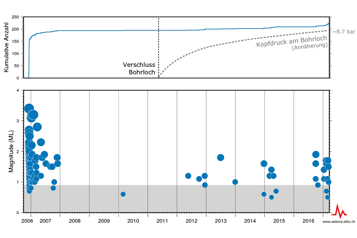
Begin of the Opening of the Geothermal Borehole in Basel
On 28 March 2017, in consultation with Basel Industrielle Werke (IWB) the Department of Health of the Canton of Basel decided to re-open the borehole in late June created in Basel as part of the "Deep Heat Mining" geothermal power project 2006. With the support of IWB, the SED has stepped up its seismic monitoring on behalf of the Canton of Basel-Stadt. In addition to routine seismic monitoring, the SED conducts a very thorough daily search for earthquakes near the borehole and automatically transmits the results to the Canton and IWB. These earthquake notifications form the basis of the traffic-light system defined by IWB, which is an important measure for reducing earthquake risk. All detected earthquakes are immediately published on the "List of Earthquakes" page.
Read more...The decision to open the borehole was prompted by an increase in microearthquake activity in the immediate vicinity of the borehole over the past few months. An extensive scientific study by the SED revealed that the increased earthquake activity will most probably subside again in the long term if the borehole is opened.
Further information on the opening process of the borehole can be found in the press release of the canton Basel-Stadt.
Further information about the geothermal project in Basel is available here.

2017-06-06
[Available in DE/FR] Leicht verspürtes Erdbeben bei Schwarzsee (FR)
Am Dienstag, 6. Juni 2017 ereignete sich um 09:18 Uhr (Lokalzeit) in der Nähe von Schwarzsee (FR) ein leichtes Erdbeben mit einer Magnitude von 3.3. Die Einwohner der Gemeinden in einem Umkreis von rund 30 km haben das Beben verspürt. Auch in den Städten Bern und Fribourg wurde das Beben vereinzelt verspürt. Innerhalb der ersten Stunde nach dem Beben sind von mehr als fünfzig Personen entsprechende Meldungen auf unserer Webseite eingegangen. Schäden sind bei einem Beben dieser Stärke nicht zu erwarten.
Read more...Das Erdbeben steht wahrscheinlich im Zusammenhang mit der Fribourger Verwerfungszone, einer in Nord-Süd-Richtung verlaufenden Scherzone, die sich in den Erdbebenkarten als 20-30 km lange, lineare Struktur abzeichnet. Das aktuelle Erdbeben ist Teil dieser linearen Struktur. Im Jahr 1999 ereignete sich ein Erdbeben der Magnitude 4.3 (ML) auf dieser Verwerfungszone, dessen Herdtiefe in nur 2 km Tiefe und somit in den Sedimentgesteinen des Schweizer Molasse Beckens lag (Kastrup et al. 2007).
In der Schweiz ereignen sich jedes Jahr einige Beben mit einer Magnitude grösser als 3. Stärkere Beben mit einer Magnitude von ungefähr 5, die möglicherweise Schäden verursachen, sind nur alle 8 bis 15 Jahre zu erwarten.
![[Available in DE/FR] Leicht verspürtes Erdbeben bei Schwarzsee (FR)](/export/sites/sedsite/home/.galleries/img_news_2017/schwarzsee_D.png_2063069299.png "[Available in DE/FR] Leicht verspürtes Erdbeben bei Schwarzsee (FR)")
2017-06-02
[Available in DE/FR] Verspürtes Erdbeben bei Sion (VS)
Am Freitag, 2. Juni 2017 ereignete sich um 21:05 Uhr (Lokalzeit) in der Nähe von Sion (VS) ein leichtes Erdbeben mit einer Magnitude von 3.3. Die Einwohner der Stadt Sitten und der umliegenden Gemeinden haben die Erschütterungen deutlich verspürt. Auch in angrenzenden Gebieten der Kantone Bern und Waadt ist das Beben bis in eine Distanz von rund 50 km vereinzelt verspürt worden. Von rund 400 Personen sind entsprechende Meldungen auf unserer Webseite eingegangen. Schäden sind bei einem Beben dieser Stärke nicht zu erwarten. Das letzte Beben mit dieser Stärke in der Region Sion ereignete sich vor gut einem Jahr. Allerdings gab es an der dort aktiven Verwerfung seither Dutzende von Beben unterhalb der menschlichen Wahrnehmungsgrenze. Im gesamten Wallis ereignen sich durchschnittlich etwas mehr als 200 Beben pro Jahr.
![[Available in DE/FR] Verspürtes Erdbeben bei Sion (VS)](/export/sites/sedsite/home/.galleries/img_news_2017/sion_DE.png_2063069299.png "[Available in DE/FR] Verspürtes Erdbeben bei Sion (VS)")
2017-04-21
Researching Induced Seismicity
Exploiting resources buried deep underground is no easy matter. Indeed, it can only be successful if a number of different factors fall into place. One frequently discussed problem concerns earthquakes that can be triggered by human activity in the subsurface. In March, more than 150 international researchers met up for the second Schatzalp workshop organised in Davos by the Swiss Seismological Service to exchange their views and findings on induced seismicity. Click here for all the posters on display and the presentations made at this workshop.
Read more...A recently published overview study investigating the current challenges associated with monitoring and handling induced seismicity showed that real-time monitoring of seismic activities in the subsurface is still not standard practice in many places. This makes it difficult to intervene promptly and take preventive measures. Furthermore, there are no standardised requirements or international norms regarding such monitoring, which especially creates difficulties for projects carried out in border areas.

2017-03-29
Opening of a geothermal borehole in Basel
On 28 March 2017, in consultation with Basel Industrielle Werke (IWB) the Department of Health of the Canton of Basel decided to re-open the borehole created in Basel as part of the "Deep Heat Mining" geothermal power project in 2006. The decision was prompted by an increase in microearthquake activity in the immediate vicinity of the borehole over the past few months. An extensive scientific study by the Swiss Seismological Service (SED) at the ETH Zurich revealed that the increased earthquake activity will most probably subside again in the long term if the borehole is opened.
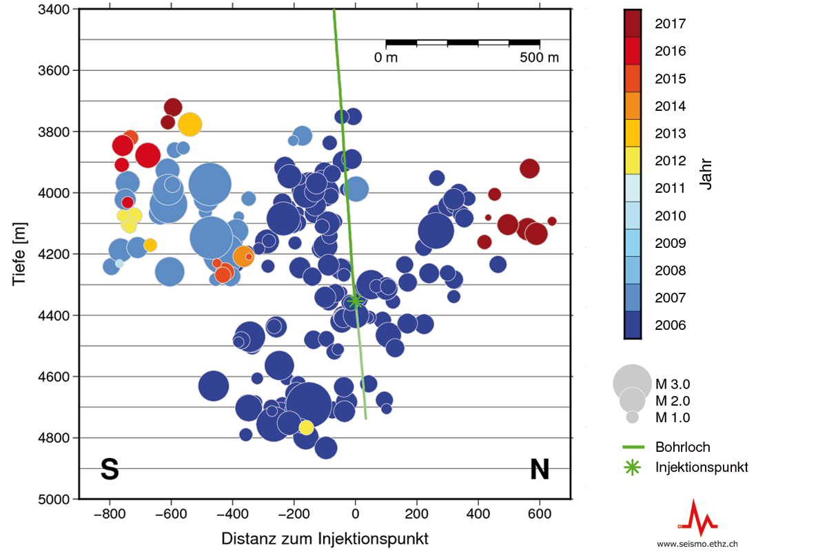
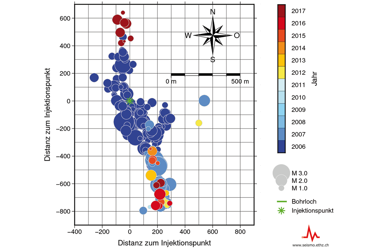
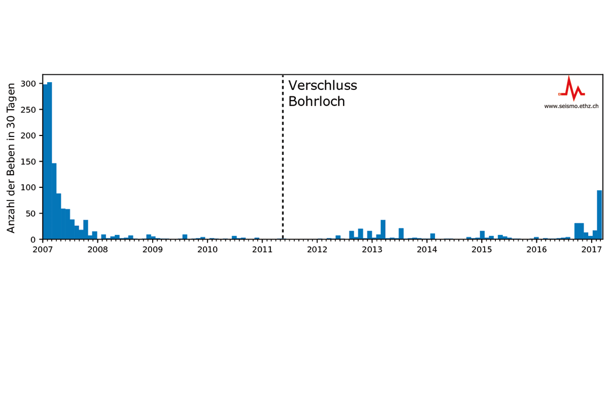
Read more...The geothermal project in Basel launched in 2006 sought to create an artificial fracture system in rock 4,000-5,000 m underground to use as a geothermal reservoir for power generation. To this end, cold water was injected into the substrate under high pressure. In the course of this process, a large number of microearthquakes occurred, some of them noticeable, and one earthquake with a magnitude of 3.4 magnitude (ML), which caused minor damage to buildings. As a result, work on the project was interrupted and then stopped altogether in 2009 after a comprehensive risk analysis. The borehole was opened in December 2006 after increased seismicity, and closed again in April 2011.
Earthquake activity in the vicinity of the borehole has been monitored by a seismic network since the start of the project. The indications from the amassed data are that seismic activity in the stimulated area has more or less continually decreased since the project ended in 2006. Roughly a year after the closure of the borehole in April 2011, seismic activity in the immediate vicinity of the borehole markedly increased again. This increase has been particularly noticeable since the second half of 2016 and typically consisted of swarms of microearthquakes, with phases of increased activity over a number of weeks being followed by quieter periods. So far, none of these earthquakes were felt by the public.
Apart from the seismic activity, in recent months the spatial distribution of the quakes has also shifted. The latest earthquakes occurred at the southern and northern edges of the previously affected area, suggesting that the artificially induced fractures are spreading. In addition, measurements show that the hydraulic pressure in the reservoir (pore pressure) has steadily increased since the borehole was closed. A detailed analysis of the seismic data and modelling of the relationship between earthquakes and increasing pore pressure have shown that even modest pressure increases in the reservoir can significantly increase seismicity.
Analyses performed by the Swiss Seismological Service (SED) show that a noticeable minor earthquake with a magnitude of 2 may well occur within the next 12 months unless steps are taken to lower the pressure. The probability of this happening is between 55% and 85%. The current probability of an earthquake as strong as the one that occurred in 2006, which had a magnitude of 3.4, is around 5%. Based on its modelling and the decline in seismicity observed between 2007 and 2011, the SED expects that opening the borehole for the next one or two years should lower the average seismicity rate by between 50% and 90% percent.
Over the past decade, the SED has advised and supported project operators and in particular cantonal authorities (e.g. Basel-Stadt, Jura, Vaud, Thurgau and the city of St. Gallen) on deep geothermics. This work focussed on seismological aspects of the environmental impact assessment (EIA), seismic monitoring and the review of operational and seismic safety concepts.
Learn more
Background report on induced earthquakes within area covered by the geothermal project in Basel (in German)
Press release by the Canton of Basel Stadt on the opening of the borehole (in German)
SED information on the geothermal project in Basel
Earthquakes and geothermal energy – a brief explanation of key correlations
2017-03-20
Two Felt Earthquakes Near Vallorcine (F)
Two earthquakes occurred near Vallorcine (F), close to the Swiss border on 20 March 2017. Both events were widely felt in the epicentral area as well as in the lower Valais between Martigny and Monthey. The first earthquake had a magnitude of 3.3 and happened at 1:31 h. The second earthquake, with a magnitude of 3.0, occurred at 22:09 h. The distance between the epicenters of two events is a few hundred meters. In general, earthquakes of this magnitude do not cause any damage. The region of Vallorcine has seen about a dozen of felt earthquakes since an earthquake with a magnitude of 4.9 on September 8, 2005.
")
2017-03-06
Summary of the magnitude 4.6 Urnerboden Earthquake
The epicenter of the Magnitude 4.6 (local or Richter magnitude ML) earthquake of 2017/03/06 21:12 local time is located about 3 km NE of the village of Urnerboden in the border region of cantons Uri, Schwyz, and Glarus. The preliminary focal depth is determined to be about 5 km. The Ml 4.6 earthquake was preceded by several foreshocks with ML ranging between 0.2 to 2.2. In the first 12 hours after the ML 4.6 event, the SED recorded about 25 aftershocks with magnitudes between ML 0.5 and 2.9. Further aftershocks, some of them perceptible, are expected over the coming days. Earthquakes with a similar or even larger magnitude than the current main shock are unlikely, but cannot be excluded.
Read more...The shaking from this event was felt by the majority of people across Central Switzerland. The Swiss Seismological Service also received more than 5000 earthquake reports from a region of about 200 km diameter, including Ticino and the cantons of Bern, Aargau, Basel, Zurich and Grisons up to Chur. The high public interest was evident also in the up to 500’000 requests per minute on the SED websites. This high demand led to the SED's web pages partially not being accessible in the first 40 minutes after the event, and after that for some time with delays.
The epicenter is located in the Helvetic nappes. The preliminary focal depth of 5 km indicates a source at the border of the sedimentary cover and the crystalline basement. The moment tensor solution for this earthquake indicates it had a moment magnitude of MW 4.1 with a strike-slip mechanism, with either a NNW-SSE or WSW-ENE striking fault plane, consistent with other events in this region. These mechanisms indicate northwest-southeast oriented compression of the crust in this region of the Helvetic domain. Last night’s earthquake occurred close to the magnitude 4.0 (ML) Urnerboden earthquake of 5 May 2003. The depth and the focal mechanism of that event are very similar to yesterday’s earthquake and it seems likely that both events are associated with the same fault system.
Generally speaking, tectonic stresses in the Alps are the result of the collision between the European and the African lithospheric plates. However, due to the complex tectonic structure and history of the Alpine collision zone, significant along-strike variations in the tectonic regimes are observed.
The highest acceleration measured by seismic instruments were reported from Linthal (GL) and reached 85 cm/s2. On average, earthquakes of this size happen approximately once every 5 years in Switzerland. The last earthquake with a similarly large magnitude was the Vallorcine (F) (4.9 ML) event close to the Swiss border near Martigny (VS) on 8 September, 2005. It was strongly felt in the Valais.
On Wednesday 7 March, the SED installed two additional stations at Urnerboden and Bisisthal. These stations will allow characterizing the aftershock sequence and thus the properties of the activated fault in more detail.


2017-03-06
Earthquake widely felt across Central Switzerland
On Monday, 6 March at 21:12 a relatively strong earthquake hit Central Switzerland. The epicenter was close to Mount Ortstock, about 6 km west of Linthal (GL. The magnitude was 4.6 on the Richter scale. The event hypocenter had a depth of around 5 km. Shaking was felt by the majority of people across Central Switzerland. However, the Swiss Seismological Service also received many earthquake reports from the cantons of Bern, Aargau, Zurich and Graubünden. The high public interest was the reason the SED's web pages were not generally accessible in the first minutes after the event.
With an earthquake of this size, small, non-structural building damage is possible near the epicenter; however the SED has not received such reports up to now. In the first two hours following the event, about a dozen aftershocks were detected of which one was strong enough to be felt near the epicenter. Further aftershocks, some of them perceptible can be expected over the coming days. It is unlikely that there will be earthquakes with a similar or even larger magnitude than the main shock, but this cannot be excluded.
Statistically, earthquakes of this size happen once every few years in Switzerland. The last earthquake with a similarly large magnitude was the Vallorcine (F) event near the Swiss on 8 September , 2005. It was strongly felt in the Valais.

2017-02-03
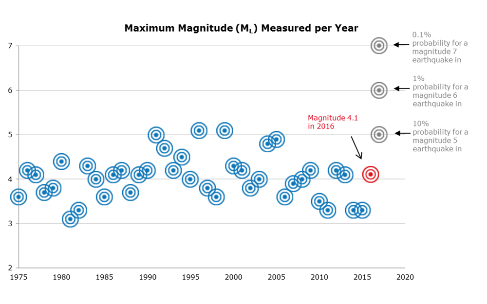
Earthquakes in Switzerland in 2016: an overview
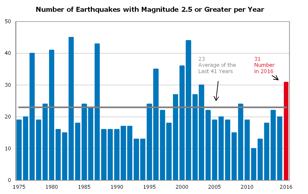
In 2016, 31 earthquakes with magnitudes of 2.5 or greater occurred in Switzerland and neighbouring countries, making it an above-average year in terms of the number of felt seismic events there. This fact is also reflected in the overall number of quakes registered by the Swiss Seismological Service at ETH Zurich, since the total of roughly 880 is slightly higher than the average from previous years.
October was a particularly active month for earthquakes in Switzerland. One of them, occurring in Leukerbad in the canton of Valais on 24 October, turned out to be the strongest earthquake of 2016. With a magnitude of 4.1, it was felt in large parts of Switzerland. Quakes as strong as this tend to occur every one to three years. The last comparable seismic event occurred near Sargans in 2013. More clearly felt earthquakes, occurred that same month, namely on 1 October on the border with France, west of Vallorcine (magnitude 3.4), and on 7 October close to Juf, in the canton of Grisons (magnitude 3.9).
Read more...Other earthquakes felt by numerous people included one that occurred to the southwest of Saint-Gingolph, on the shore of Lake Geneva, on 22 December (magnitude 3.4) and a weaker, shallow quake (magnitude 2.2) beneath the town centre in Solothurn on 20 August. A few people also felt some of the events associated with the series of serious earthquakes in central Italy, which claimed more than 300 lives. On average, similarly powerful earthquakes hit Switzerland every 50 to 150 years.
At 31, the number of quakes with a magnitude of 2.5 or more is clearly above the long-term average that has applied for the last 41 years. On average, 23 such potentially perceptible earthquakes take place in Switzerland every year. Altogether, some 880 seismic events were recorded in Switzerland and neighbouring countries in 2016. Fluctuations in the long-term average of earthquake frequencies are normal and do not permit any statements about future seismicity in Switzerland. In 2016, as in other years, most seismic activity was recorded in Valais, the canton of Grisons and along the northern edge of the Alps.
Like in previous years, several earthquake swarms were recorded in 2016. One of the most active sequences occurred northeast of Sion, with three clearly felt seismic events in May, June and November. All in all, more than 80 events were registered. The largest quake took place on 24 June, reaching a magnitude of 3.2. An earthquake swarm hit the same area in 2015. Both swarms probably have to do with a fault line on the northern edge of the Rhone Valley. In addition, the Swiss Seismological Service detected a sequence of more than 50 clearly perceptible quakes on the German-Swiss border area, northeast of Thayngen. Earthquake swarms are usually characterised by the absence of a pronounced main quake. The strongest quake often occurs midway through or towards the end of the quake sequence. Earthquake swarms can extend over a period ranging from a few hours to several months or even years.
2017-01-22
No Earthquake Near Samnaun: What Triggers False Alerts
On Sunday, 22 January 2017, based on fully automated evaluations, the Swiss Seismological Service erroneously reported an earthquake with a magnitude of 3.3 that was supposed to have happened near Samnaun in the canton of Graubünden at 5.48 a.m. During the ensuing routine control by a seismologist, it quickly became clear that the algorithm that is supposed to automatically detect and localize earthquakes had got things a bit muddled up. The seismic waves of a very large and deep earthquake in Papua New Guinea were mistaken for an earthquake in Switzerland. The earthquake notification was quickly corrected, and the media and authorities were notified that it was a false alert. Automation errors of this kind occur every few years in all seismic networks. Unfortunately, these false alerts cannot be completely avoided. That is why we would like to provide the following explanation.
Read more...Earthquakes happen without any prior warning, and their waves travel at a speed of a few kilometers per second. A larger local earthquake is, therefore, felt within 30 to 40 seconds throughout Switzerland and creates uncertainty: What was it? How strong was it? Where did the vibrations occur? In order to make this information available in seconds, our computers continuously scan the data from more than 150 seismometers, which record ground movements across Switzerland. As the ground often “shakes” at one station when, for instance, a truck drives past, the algorithm requires the seismometers to detect a significant increase above the signal-to-noise ratio at several stations simultaneously (i.e. within a few seconds). Only then does the computer suspect an earthquake. It subsequently determines its origin by using a kind of cross bearing and its magnitude using the measured amplitude of the signal. This works in 99.9 percent of cases and enables us to provide information within one minute by e-mail, Twitter, and the Internet.
Sometimes, however, things can go wrong: In today’s case, an earthquake in Papua New Guinea confused our computers. At 5.30 a.m., the earth cracked at a depth of more than 130 kilometers along a rupture surface 100 to 150 kilometers long, resulting in a large earthquake with a magnitude of 7.9. As it happened deep in the earth, hopefully no one was injured. The earthquake waves spread across the entire globe, and after around 18 minutes, they also reached Switzerland (watch this short video, only available in German). The first waves hit Switzerland almost vertically from below and were, therefore, recorded at the almost same time at all stations. Our computers correctly detected an earthquake, but determined it originated 60 kilometers below the Engadine. The quality of localization was classified as not particularly good by the software, but it was just good enough to reach the prescribed threshold value for the issuing of the alert. Fortunately, the magnitude was estimated as being far smaller, as the energy of the waves had already weakened considerably on their long journey from Papua New Guinea to Switzerland. Thus, the notification of a Swiss earthquake was sent out into the world – although accompanied by the warning that it was an automatic localization that had not been confirmed by a seismologist.
We could further reduce the risk of such false alerts, but this would have consequences. Stricter automatic quality criteria would be helpful, but it would also increase the risk of missing and not reporting an earthquake (for us, this would be at least as bad as a false alert). We could have all earthquakes verified first by a seismologist, but that would take at least 20 to 30 minutes – a long time in the age of online media. Therefore, all we can do as seismologists is apologize when something goes wrong (and we do indeed apologize again here), continue refining the algorithms of our automated alerts, and, last but not least, share this comforting thought with you: computers cannot do everything better than humans (yet?).
