Earthquakes in the Valais
More earthquakes occur in the Valais than anywhere else in Switzerland. The region therefore has the country's highest seismic hazard, although Switzerland's strongest known quake occurred in Basel (Basel 1356).
Over the past 10 years, the SED has recorded an average of around 270 earthquakes per year in the Valais and its immediate surroundings, of which only two or three a year were felt by local residents. In statistical terms, an earthquake with a magnitude of around 6 occurs in the Valais approximately every 100 years on average. This equates to a probability of occurrence of roughly 1% per year for such a quake.
Historical records confirm that a damaging earthquake has occurred almost once every century for the past 500 years. The last such quake hit the area around Sion in January 1946, claiming four lives and causing millions of francs' worth of damage. Today, with denser settlement and vulnerable infrastructure, the damage from an earthquake of this magnitude would be many times greater.
Seismic activity in the Valais
Over the past 40 years, 62 earthquakes with a magnitude of 3 or greater have occurred in the Valais and its immediate surroundings. All were felt by local residents. Six attained a magnitude of more than 4 and were felt over a wider area. The strongest earthquake in this period took place in Vallorcine, on the French border between Martigny and Chamonix. That occurred on 8 September 2005 and had a Richter magnitude of 4.9 and an epicentral intensity of V. The latter means that it caused damage to multiple buildings, such as cracks in masonry, and triggered a number of small rock slides and landslides along roadside embankments. Smaller, imperceptible earthquakes had occurred in the same epicentral area in the preceding years. The main Vallorcine quake was followed by a prolonged series of several hundred aftershocks; a magnitude 3.2 earthquake was recorded there as late as 2014.
| Magnitude | Number |
| ML ≥ 2.0 | 998 |
| ML ≥ 2.5 | 314 |
| ML ≥ 3.0 | 109 |
| ML ≥ 4.0 | 11 |
Table: Magnitude frequency in and around the Valais between 1975 and 2022. ML is the local magnitude on the Richter scale.
| Datum | Magnitude | Ort |
| 05.03.1977 | 4.1 | Iffigenalp |
| 30.09.1989 | 4.1 | Wildhorn |
| 14.02.1990 | 4.2 | Bonneveaux |
| 14.06.1993 | 4.2 | Domodossola |
| 31.03.1996 | 4.2 | Valpelline |
| 08.09.2005 | 4.9 | Vallorcine |
| 24.10.2016 | 4.1 | Salgesch (VS) |
| 01.07.2017 | 4.3 | CHATEAU-D'OEX (VD) |
| 28.05.2019 | 4.2 | Novel (F) |
| 01.07.2021 | 4.0 | Furkapass/Rhonegletscher (VS/BE) |
| 05.10.2021 | 4.1 | Arolla (VS) |
Table: Earthquakes with a magnitude (ML) greater than 4 in and around the Valais between 1975 and 2022.
Although the first seismographs in Switzerland began operating in the early 20th century, a uniform national seismic monitoring network has only existed since 1975. This has been continually expanded and adapted in line with the latest technological developments. As a result, its sensitivity and location accuracy have improved significantly over time.
The epicentres of instrumentally recorded earthquakes in and around the Valais between 1975 and 2014 differ significantly in their distribution (see epicentre map 1975 - 2014): while the seismic foci south of the Rhone Valley are rather diffuse, with the odd cluster here and there, seismic activity north of the Rhone Valley is concentrated in an elongated area running west-south-west (WSW) to east-north-east (ENE) more or less parallel to the valley itself. There is also a conspicuous cluster of quakes towards Chamonix on the French border (Vallorcine) and east of Zermatt (Cima di Jazzi). It is worth pointing out that the Rhone Valley itself has virtually no seismic foci, despite being a fault zone that separates two different regional tectonic units and must have been seismically active in the geological past.
Historical records are the only information we have about earthquakes in times past. The strength of these quakes can be reconstructed based on the documented damage and quantified in the form of intensities. Although in principle it is possible to estimate a magnitude based on the observed intensities, this would be subject to considerable uncertainty.
In the Valais and surrounding areas, 30 earthquakes with intensities between VI and VIII are known to have occurred since the start of the 16th century. All of these quakes caused minor to severe damage to buildings and in some cases injuries and fatalities. Of these 30 quakes, eight are part of a series that occurred south of Visp in 1855 and five are part of a series north of Sierre in 1946. Nine earthquakes with intensities of at least VIII are known to have occurred in Switzerland from historical records; five of these took place in the Valais.
List of known earthquakes with intensity = VIII in and around the Valais:
| Date | Intensity | Location |
| ??.04.1524 | VII | Ardon |
| 11.03.1584 | VIII | Aigle |
| 09.12.1755 | VIII | Brig / Naters |
| 25.07.1855 | VIII | Stalden / Visp |
| 25.01.1946 | VIII | Sierre / Ayant |
Over the past 500 years, an earthquake causing major damage to buildings in the Valais has occurred in the middle of each century. Information becomes patchier the further back in time you go. However, it is safe to assume that earthquakes with the potential to cause major damage to buildings also occurred in the Valais prior to 1500. The most recent damaging earthquake in the Valais took place near Brig on 23 March 1960. It had an intensity of VII. Things have been relatively quiet since then, with no earthquake exceeding an intensity of V.
Visp 1855
For the earthquake in Visp on 25 July 1855, with an estimated magnitude of 6.2, it has been possible to accurately reconstruct the extent of the damage. This applies to both the geographical extent of the damage area and the scale of the damage within the directly affected localities. The earthquake reached its maximum intensity of VIII in the Vispertal valley, where it destroyed large parts of the settlements of Visp, Stalden, Törbel, Grächen and St. Niklaus. It killed one person and left dozens injured. Hundreds of boulders were dislodged while entire hillsides gave way and slid into the valley, burying roads and causing existing springs to dry up and new ones to emerge. The earthquake produced intensity VI effects (minor damage to buildings) in Geneva, Basel, Zurich and Schaffhausen, and could be felt as far away as Paris, Lyon, Genoa, Ingolstadt and Mainz. Hundreds of aftershocks were felt for years afterwards, including eight intensity VI to VIII quakes which caused further damage to buildings up to the end of 1855.
Sierre 1946
The earthquake in Sierre on 25 January 1946 was Switzerland's most powerful quake of the 20th century. From a few seismograms recorded abroad, it was possible to calculate the moment magnitude as 5.8, which corresponds to a Richter magnitude of approximately 6.1. The earthquake claimed three lives and caused severe damage to around 3,500 buildings in Sierre, Sion and surrounding areas. Over 500 aftershocks were felt up to the end of 1946 alone, including four with intensities of VI and VII. A particularly noteworthy aftershock occurred on 30 May 1946. This triggered a massive rock avalanche on the Rawilhorn, whose traces can still be seen in the landscape today. Earthquakes had been repeatedly documented in the wider epicentral area of the 1946 quake prior to that event and it is also possible that the cluster of epicentres north of Sion and Sierre, which can still be seen today on maps of instrumentally recorded events, is linked to the 1946 earthquake.
The Sierre earthquake today
The damage caused by the 1946 earthquake would be valued at around CHF 26 million in today's money. As the area is now more built-up, the consequences of an equally powerful quake today would be much greater. Unlike in 1946, the floor of the Rhone Valley is now densely populated and home to large industrial facilities. The subsoil is also unfavourable since the soft sediments of the valley floor amplify seismic waves by up to 10 times compared with a hard subsurface. This means the shaking would be much stronger here than in rocky areas, resulting in greater damage to buildings and possibly causing some buildings to collapse. Since even many new buildings could probably not withstand a strong earthquake under these conditions, up to 7,000 moderately to severely damaged buildings would be expected. In addition, up to 40 people could be killed and up to 300 injured, with up to 9,000 people seeking shelter. The building damage in such a scenario would amount to approximately CHF 2.5 billion.
Earthquakes in the Valais often occur as a series of events, corresponding to the aforementioned cluster of epicentres. The duration of these series can vary considerably, with some lasting just a few days while others, such as the Vallorcine series, continue for several years. Typically, such series involve a large number of earthquakes in a localised area over an extended period of time, without a clear sequence of foreshocks, main quake and aftershocks. This is also known as an earthquake swarm. Swarm activity usually ends after a few weeks or months, but occasionally the quakes increase in strength and number over time. If the location of the individual foci in such swarms can be calculated with sufficient accuracy, it always defines one or more surface areas that correspond to the fracture surfaces activated by the earthquakes in the subsurface. Two well-investigated examples of such earthquake swarms in the Valais are the series of quakes that occurred around Martigny in 2001 and around Sierre in 2011.
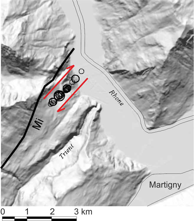
The Martigny earthquake series
Between 8 January and 24 October 2001, 27 events with magnitudes between 1.1 and 3.6 were recorded in the vicinity of Martigny. Ten of these occurred between 23 and 28 February, including two quakes with magnitudes of 3.6 and 3.5. Oriented south-west to north-east (SW-NE), the vertical fracture surface activated by this series lies at a depth of around 6 km and extends for a length of almost 2 km.
Figure: Precise locations of the Martigny 2001 earthquake series showing the shear fracture directions.

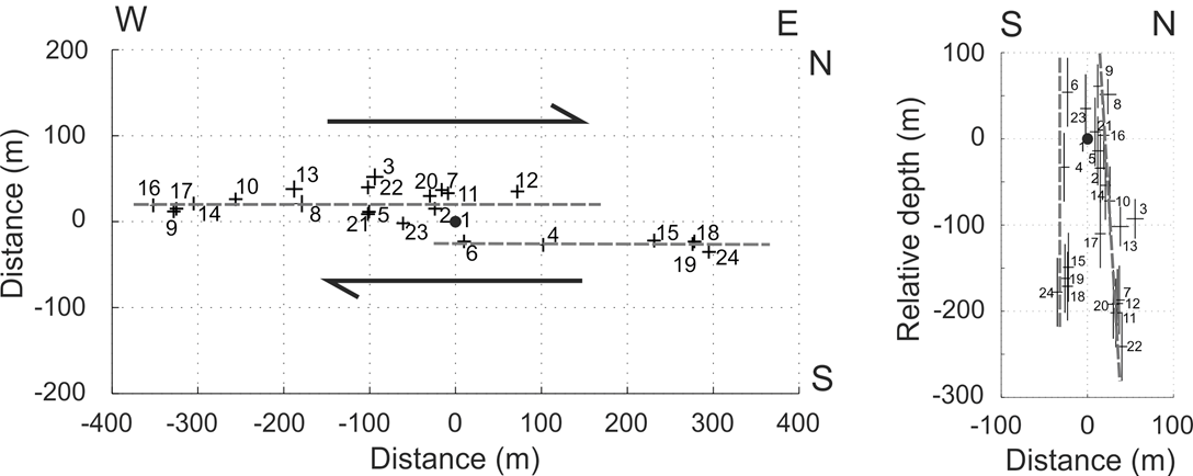
The Sierre earthquake series
A swarm of 31 earthquakes began near Sierre on 8 January 2011. Sixteen of these earthquakes occurred in the first five hours, including two with magnitudes of 3.3 and 3.2. A further nine events followed in the next two weeks and the remaining six over the rest of the year. The individual seismic foci were located at depths of 6 to 7 km on two vertical, slightly staggered fracture segments running west to east (W-E), with a total surface area of approximately 800 x 400 m.

Figure: Precise locations of the Sierre 2011 earthquake series (left: epicentre map, right: depth section) showing the shear fracture directions.
Val d’Illiez: an earthquake series induced by the filling of Lac de Salanfe
In the winter of 1953/54, 12 earthquakes with estimated magnitudes between 3 and 4 occurred in the municipality of Val d’Illiez, west of Saint Maurice. Given that on average only one or two quakes with magnitudes greater than 3 occur in the whole of the Valais each year, this series was exceptional. The previous summer, the Lac de Salanfe reservoir, located around 7 km to the south-south-east, had been filled for the first time. In the same winter, a new thermal spring appeared in the Buchelieule area of the municipality. It is still in use as a spa today. A link between the filling of the reservoir and the emergence of thermal water in the neighbouring valley is plausible, given the position of the local rock strata.
Increased seismic activity caused by reservoirs is a well-known phenomenon worldwide, as damming a reservoir inevitably increases the underground water pressure. This weakens the rock, which can cause the stresses in the rock to suddenly discharge in the form of earthquakes. The change in pressure and the earthquake-induced rupture processes in the rock very likely opened new flow paths in the subsurface, resulting in the emergence of the new thermal spring.
The Salanfe reservoir remained below its maximum water level for years due to the seepage of large quantities of water into the subsoil. Following extensive construction work to seal the basin, the water rose to a previously unseen level in the autumn of 1995. The following winter, unusually high seismic activity was again detected in the area between Lac de Salanfe and Val d’Illiez. Although there were no magnitude 3 quakes this time, over 30 events with magnitudes greater than 1 were recorded in the space of half a year – an exceptional number compared with the annual average of around eight events per year. The Val d’Illiez/Lac de Salanfe case is thus a classic example of induced earthquakes triggered by disruptions to hydraulic conditions in the subsurface as the result of human intervention.
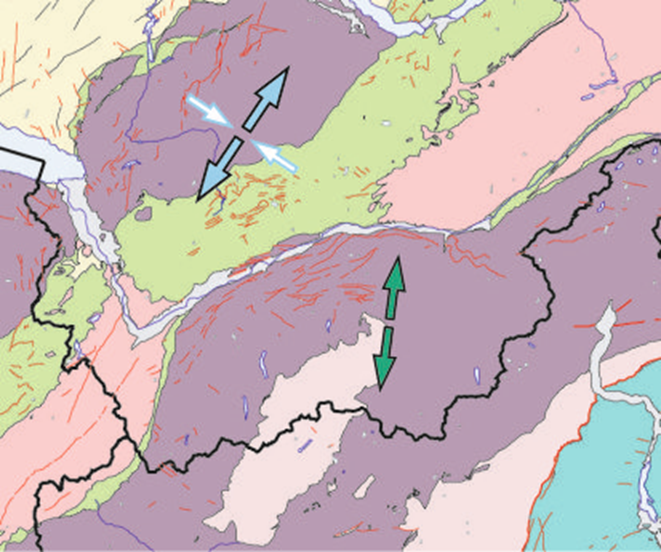
Essentially, earthquakes are caused by the sudden release of stresses in the earth's crust. These stresses are brought about by large-scale continental movements. If they are stronger than the rock, a sudden rupture occurs along existing areas of weakness in the subsurface, triggering the seismic waves felt on the earth's surface. Modern seismology uses seismic observations to draw conclusions about the causative stresses and so deduce regional differences in the stress field.
In the northern Valais, as in the northern Alpine foothills, the stresses in question are those caused by the opening of the Atlantic and the collision between Africa and Europe, which are also responsible for the formation of the Alps. In the southern Valais Alps, however, most earthquakes are evidence of lateral spreading: this results from a superposition of stresses from the ongoing collision between Africa and Europe and of compensatory stresses caused by the topography of the Alps and their roots. Obviously, stresses in the earth's crust have changed over the course of millions of years.

Figure: Map detail showing directions of tectonic stresses
The Valais has Switzerland's highest seismic hazard, along with the Basel region. Earthquake-resistant residential or office buildings in Switzerland are designed to withstand shaking that is expected to occur where the building is situated once every 500 years on average. This is illustrated on the seismic zone map. Most of the Valais, including the Rhone Valley, belongs to zone Z3b. In this zone, shaking with a maximum intensity of VIII-IX (severe to destructive building damage) is expected to occur once in 500 years. The far west and far east of the Valais and the adjoining northern slopes fall into zone Z3a. In this zone, shaking with a maximum intensity of VII-VIII (moderate to severe building damage) is expected to occur once in 500 years.
Amplification of seismic waves in the Rhone Valley
As well as the magnitude and epicentral distance, the local subsoil type has a major impact on the amount of damage caused by an earthquake. In the Rhone Valley, for example, unconsolidated river and lake deposits can strengthen seismic waves, meaning that the ground motion intensity on a valley floor may be up to 10 times greater than in the rocky substrate of the valley sides. To understand the impact of these site effects during past and future earthquakes, the propagation of seismic waves is computer-simulated and compared with recordings from seismic instruments.
Secondary natural hazards triggered by earthquakes
The impact of earthquakes is not limited to shaking and direct damage to buildings. Additional damage is often caused by other natural hazards triggered by earthquakes. Shaking can cause waterlogged loose sediments to liquefy and lose their solidity, leading to the complete collapse of buildings whose foundations are not site-appropriate. The unstable slopes commonly found in mountainous regions may be suddenly weakened by earthquake-induced shaking, causing rockfalls or landslides into the valley below. These may destroy transport links and energy and communications infrastructure. The same is true of avalanches in winter. Also, embankments and the sides of lake basins formed of unconsolidated sediments may start to slip. These can trigger massive water waves that travel across a lake as a tsunami, causing devastating floods. Studies of past earthquakes show that the Valais, with its soft valley floors and steep mountainsides, and the adjoining areas around Lake Geneva are exposed to these additional earthquake-induced natural hazards. This must definitely be taken into account when assessing the earthquake risk. However, the earthquake risk model of Switzerland does not yet take such secondary consequences of earthquakes into account.
High earthquake risk
As well as facing a high seismic hazard, many parts of the Valais are also subject to a high earthquake risk (also referred to as seismic risk). This applies particularly to larger towns and cities in the Rhone Valley.
For example, according to the estimates of the earthquake risk model, a magnitude-6 earthquake near Sion would cause building damage amounting to approximately CHF 4.5 billion, claim around 100 lives and injure about 700 people. Such an earthquake occurs in this area on average every 340 years.