Earthquake hazard model of Switzerland
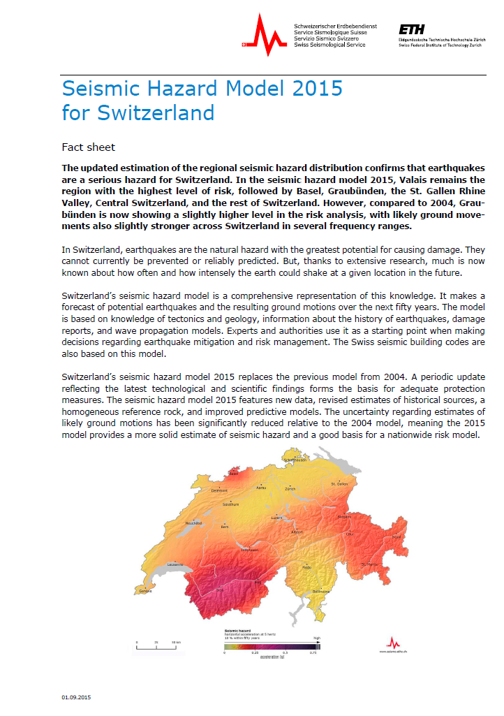
The earthquake hazard model of Switzerland makes a prediction of how often and how strong the earth could shake at a certain location in the future. The model is based on knowledge of tectonics and geology, information about the history of earthquakes, damage reports, and wave propagation models.
Switzerland’s earthquake hazard model 2015 replaces the previous model from 2004. A periodic update reflecting the latest technological and scientific findings forms the basis for adequate protection measures. The seismic hazard model 2015 features updated data, revised estimates of historical sources, a homogeneous reference rock, and improved predictive models. The uncertainty regarding estimates of likely ground motions has been significantly reduced relative to the 2004 model, meaning the 2015 model provides a more solid estimate of seismic hazard and a good basis for the earthquake risk model.
Experts and authorities use it as a starting point when making decisions regarding earthquake mitigation and risk management. The Swiss seismic building codes are also based on this model.
Model development
Measuring data
High-quality data was incorporated in the reassessment of the seismic hazard for a period of ten years in the national digital broadband and strong motion measurement network. Switzerland has one of the most modern and densest seismic measurement networks worldwide. It annually records 1.000 to 1.500 earthquakes in Switzerland. Knowledge about the distribution of the small and medium earthquakes is an essential aid for estimating future earthquake activity. The recorded ground accelerations also make it possible to develop improved ground movement forecast models.
Historical data
Numerous data sources were reevaluated in the scope of the revision of the historical Swiss Earthquake Catalog. They provide important information about all known damaging earthquakes and their effects up to 1975. Since this time, the seismic network in Switzerland has enabled the nationwide instrumental monitoring of earthquake activity. Historical seismology makes a critical contribution to the hazard analysis by assessing the effects of major earthquakes in the past. Such earthquakes only occur rarely in Switzerland, and, in comparison to their return period, the observation period of instrumental seismology turns out to be very short.
Macroseismic data
Macroseismology is a classification of the shaking caused by earthquakes based on the effects observed by persons. It makes it possible to reliably estimate the magnitudes and epicenters of historical earthquakes and link these to modern data.
Homogeneous reference rock
Extensive geophysical measurements at different seismometer stations in Switzerland make it possible to determine the influence of the local geology on the recorded seismograms. Effects of the seismic focus, the spread of the seismic waves, and thus the local amplifications can be reliably differentiated this way. This makes it possible to determine the ground movement for a rocky reference surface with a defined speed-depth profile and an average speed of 1,100 m/s. It was not yet possible in 2004 to reliably calculate the influence of the local amplification. This is an essential advancement in comparison to the seismic hazard model 2004 and makes it possible to reduce the uncertainties in the risk estimate.
Forecast models
In the past 10 years, extensive high-quality seismic data was recorded worldwide in direct proximity to strong earthquakes. The data thus obtained enables an improved understanding of the influences of the local ground, which leads to clearly more reliable forecast models of the ground movement with the aid of modernized analysis methods. The forecast models now also cover a much broader frequency range, which is important for the implementation of the hazard analysis in the construction engineering sector.
Alternative zoning
The SED has developed alternative approaches in order to statistically analyze and visualize the distribution of earthquakes according to location, time, and magnitude. This alternative to classic seismotectonic zoning is of particular advantage for regions with spatially distributed seismicity without domineering fault zones, such as can be encountered in the Alps.
Mathematical models
The open-source software platform OpenQuake, developed in the Global Earthquake Model (GEM) project with participation of the SED, enables a much-improved calculation of the seismic hazard. More complex models make it possible to consider uncertainties to a larger extent and estimate them more precisely. Furthermore, the ground movements are not only modeled for spot sources, but can also be modeled for extensive fissures with varying fissure orientations.
Data access
For experts, the SED provides different components of the hazard model SUIhaz15 on the data portal of the European Facilities for Earthquake Hazard and Risk EFEHR. The portal provides interactive access to the different products of the model (maps, hazard curves, uniform hazard spectra), as well as the option to download data. It also features additional expert background information and links.
You can also find all of the background information on Switzerland’s earthquake hazard model, which was published in September 2015, in the comprehensive SUIhaz2015 report.


