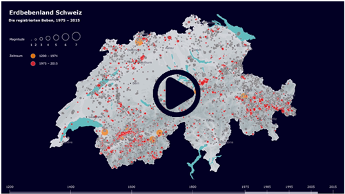
Overview of the earthquake hazard in Switzerland
Earthquakes cannot currently be prevented or reliably predicted. But, thanks to extensive research, much is now known about earthquake hazard. Using a model, earthquake hazard shows how often and how intensely the earth could shake at a given location in the future.
Switzerland’s earthquake hazard model is based on knowledge of tectonics and geology, information about the history of earthquakes, damage reports, and wave propagation models. Experts and authorities use it as a starting point when making decisions regarding earthquake mitigation and risk management. The Swiss seismic building codes are also based on this model.
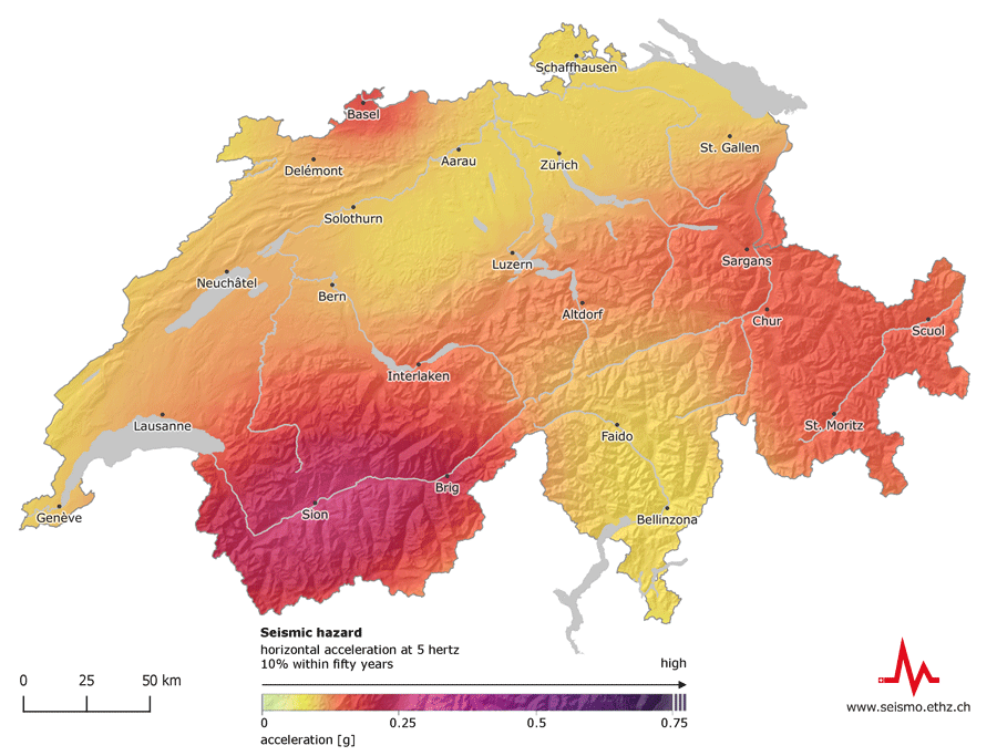
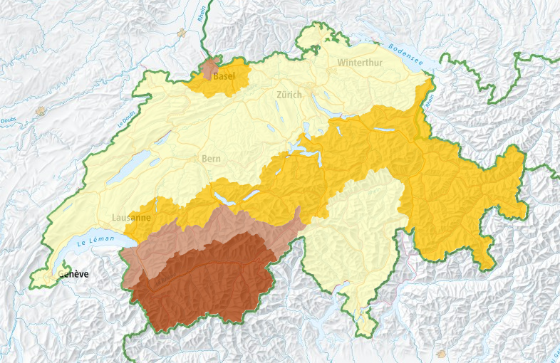
What is shown on the earthquake hazard map of Switzerland?
The earthquake hazard map illustrates the horizontal acceleration at 5 hertz; the probability of a building constructed on rocky subsoil experiencing this is 10 % within fifty years.
Earthquake hazard in Switzerland
The earthquake hazard model confirms that Switzerland is an earthquake-prone country. On average, an earthquake with the magnitude of 5 can be expected to occur every 8 to 15 years, even though the last earthquake of this magnitude dates back roughly 25 years (Vaz GR, 1991). With such an earthquake, extensive damage to buildings is likely, depending on the region and the depth. Earthquakes with a magnitude of 6 or greater, which may cause vast and partially severe damage, occur every 50 to 150 years on average. Earthquakes of this magnitude are principally possible at anytime and anywhere in Switzerland. The last earthquake of this magnitude occurred in Upper Valais in 1946 (Sierre VS, 1946).
As expected, the spatial distribution of the seismic hazard 2015 in comparison to 2004 has not changed significantly. Valais remains the region with the highest level of hazard in Switzerland, followed by Basel, Grisons, Central Switzerland, the St. Gallen Rhine Valley, and the rest of Switzerland. The hazard estimate for Grisons is now similar to the one for the Basel region. This slightly higher classification of the canton of Grisons can be explained by an adjusted evaluation of previous earthquakes.
Besides the slightly elevated hazard estimation for the canton of Grisons in comparison to other regions, the seismic hazard model 2015 shows higher values for likely ground movements in many frequency ranges compared to 2004. This is primarily due to the evaluation of extensive newly recorded data in proximity to strong earthquakes in Switzerland and abroad. They often turned out to be higher than previously expected.
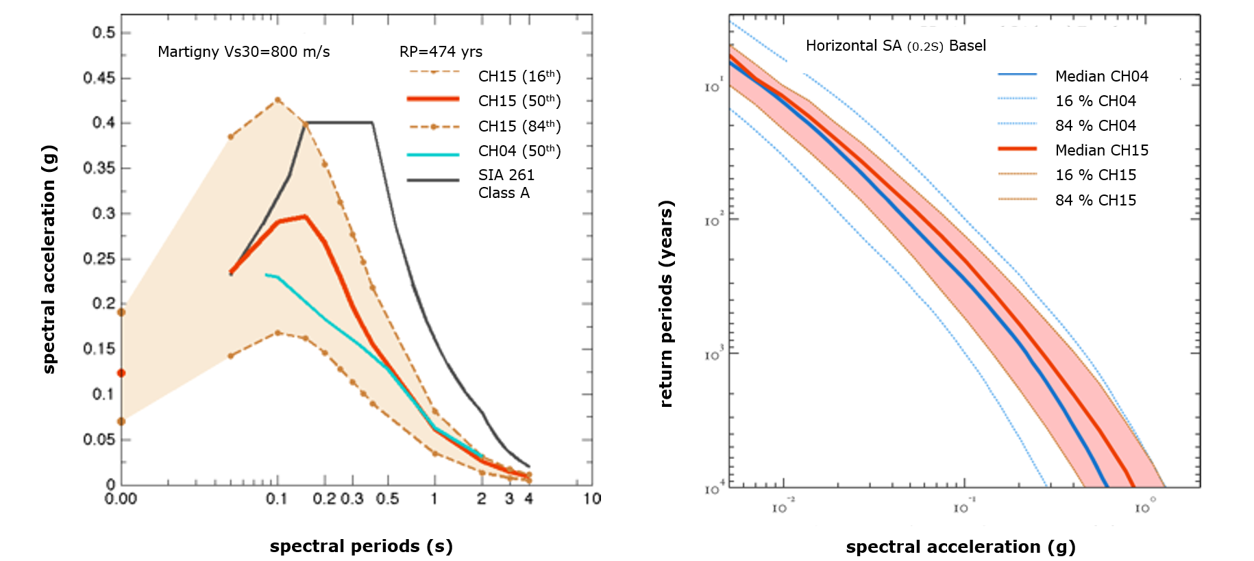
The figure on the left shows an example comparison, at Martigny, of the 2015 hazard model (CH15) with the 2004 model (CH04) for various frequencies and the SIA-defined standard spectra (SIA261).Compared with CH04, CH15 covers a wider frequency range and for certain frequencies shows somewhat higher hazard. On the right we compare the models using so-called hazard curves — the expected return periods of spectral acceleration — for Basel at a frequency of 5 Hz.
The relative differences between 2015 and 2004 are approximately 30 percent for a return period of 475 years and a frequency of 5 Hz for a location in Valais. This corresponds to 0.07 g absolute (gravity acceleration). The rise in percent is higher in regions with lower hazard, such as Central Switzerland or Jura: Although the values here only increased by 0.03 to 0.05 g in absolute, this corresponds to a relative increase of 50 to 70 percent. As of a frequency of 2 Hz or less, however, the values from 2015 are similar to the values from 2004, or up to 10 percent lower in some regions. In general, the uncertainties in the estimation of likely ground movements are 2015 considerably fewer than in 2004. Less substantial uncertainties are a sign that the numerous work efforts that form the basis of the new seismic hazard model are paying off.
