News Archive 2022
2022-12-21
Merry Christmas and a Happy New Year
.

2022-12-21
InSight mission ends, though research work will continue
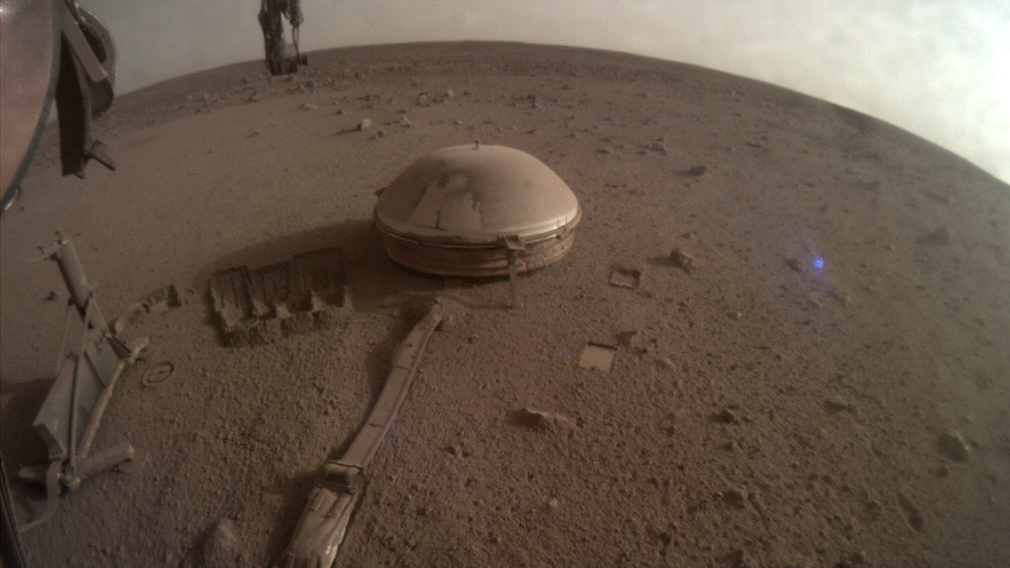
Image: Nasa / JPL
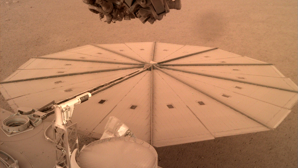
Image: Nasa / JPL
Just over four years since the InSight lander arrived on Mars, the mission has ended. The lander has insufficient power to continue to operate, due to the layer of dust that has steadily accumulated on its solar panels.
Read more...The InSight mission launched from Earth in the late spring of 2018 with the aim to explore the interior of the red planet. The key instrument on board was a seismometer package called SEIS, for which ETH Zurich contributed the electronics. Some months after, once fully deployed on the Martian surface, SEIS recorded the first Martian tremors.
The Swiss Seismological Service at ETH Zurich (SED) together with the group for Seismology and Geodynamics at ETH Zurich lead the Marsquake Service (MQS), a mission-level team of seismologists in charge of SEIS data analysis. Similar to what is done in a seismic service on Earth, the MQS is responsible for the review of all seismic data, identification and characterization of marsquakes and production of the seismic catalogue. The MQS is modelled on the seismic service at the SED, despite the fact that in Switzerland there are over 200 stations monitoring activity in and around the territory, whereas on Mars a single station was used to monitor the seismicity of the entire planet! Since SEIS began delivering data, MQS detected 1,318 marsquakes, including a handful of quakes caused by meteoroid impacts. These marsquake recordings allow scientists to study the planet’s crust, mantle, and core.
With the mission coming to end, the routine daily operations of the MQS come to a halt. However, the analyses of the wealth of data SEIS recorded will continue and will certainly reveal further interesting details about Mars’s interior.
Learn more about the achievements and the end of the NASA InSight mission here.
2022-10-27
[Available in DE/FR] Erdbeben bei Monthey (VS)
In der Nähe von Monthey (VS), südwestlich von Aigle, wurde am Dienstag, 25. Oktober 2022 um 21.11 Uhr (Lokalzeit) ein Erdbeben der Stärke 1.6 in einer Tiefe von etwa 1.5 Kilometern gemessen.
Beim Schweizerischen Erdbebendienst an der ETH Zürich sind vorwiegend Verspürtmeldungen aus Monthey (VS) und der näheren Umgebung eingegangen. Ein Erdbeben der Stärke 1.6 ist normalerweise für Menschen nicht spürbar. Aufgrund des Zeitpunkts des Bebens am späteren Abend, wenn viele Leute Zuhause einer ruhigen Tätigkeit nachgehen sowie seines untiefen Erdbebenherdes verspürten es viele Personen. Es gingen zudem vereinzelt Berichte über Knallgeräusche ein. Solche Geräusche entstehen, wenn Erdbebenwellen an die Oberfläche treffen und sind eine häufige Begleiterscheinung von Erdbeben. Die Schwingungen des Bodens werden in die Luft übertragen und erzeugen Schallwellen. Knallartige Geräusche entstehen, wenn relativ viel Energie in hochfrequenten Wellen an die Luft abgegeben wird.
![[Available in DE/FR] Erdbeben bei Monthey (VS)](/export/sites/sedsite/about-us/.galleries/img_news_2022/monthey_map.png_2063069299.png "[Available in DE/FR] Erdbeben bei Monthey (VS)")
2022-10-14
[Available in DE] Earthquake close to Triesenberg (FL)
Am Freitag, dem 14. Oktober 2022 hat sich um 17:33 Uhr (Lokalzeit) bei Triesenberg (FL) südöstlich von Vaduz in einer Tiefe von ungefähr 2 km ein Erdbeben der Magnitude 3.1 ereignet.
Die Erschütterungen waren vorwiegend im Gebiet um Triesenberg, aber auch in Triesen, Vaduz, Schaan und Balzers gut zu spüren. Zudem haben Personen aus weiteren Gemeinden, vorwiegend im Rheintal im Umkreis von ca. 10 km, das Beben wahrgenommen. Bis eine Stunde nach dem Erdbeben sind beim Schweizerischen Erdbebendienst (SED) an der ETH Zürich über 300 Meldungen aus der Bevölkerung eingegangen. Bei einem Erdbeben dieser Stärke sind in der Regel keine Schäden zu erwarten.
Read more...Das Beben gehört zu einer Serie von Erdbeben bei Triesenberg, deren bisher grösstes am 01. September 2022 stattfand und eine Magnitude von 3.9 aufwies (siehe Aktuell-Beitrag vom 01.09.2022). Das Beben wurde damals von einigen spürbaren Vor- und Nachbeben begleitet. Weitere Erdbeben in den nächsten Stunden und Tagen sind nicht auszuschliessen, die Wahrscheinlichkeit von deutlich grösseren Beben mit Schadenfolgen ist jedoch klein.
![[Available in DE] Earthquake close to Triesenberg (FL)](/export/sites/sedsite/about-us/.galleries/img_news_2022/20221014_Triesenberg_Shake_map.PNG_2063069299.png "[Available in DE] Earthquake close to Triesenberg (FL)")
2022-09-25
Earthquake felt near Vallorcine (F)
An earthquake of magnitude 3.7 was observed near Vallorcine (France, close to the Swiss border), at a depth of about 6 kilometers on Sunday morning, September 27, at 8:18 local time.
In Switzerland, the earthquake was felt mainly in the region of Martigny, partly also in other settlements of the Rhone valley and its southern tributary valleys. The Swiss Seismological Service has received about 100 felt reports within the first hour after the event. In case of an earthquake of this magnitude, no damage are expected, nor was reported.
The region of Vallorcine is regularly hit by small earthquakes, among which felt ones nearly every year. The largest events happened on September 8, 2005 (magnitude 4.9) and June 23, 2020 (magnitude 3.8).
")
2022-10-04
20 seismic stations in Bosnia and Herzegovina contribute to the initiative “AdriaArray”
The Swiss Seismological Service (SED) at ETH Zurich is now part of a new European initiative called AdriaArray. The international collaboration with teams across Europe aims to seek answers to fundamental questions related to plate geodynamics and the deformation of the Adriatic Plate. This microplate stretches throughout Eastern Italy and borders Switzerland and Austria, and goes all along the coast of the Balkan countries to Greece. Millions of years ago, the collision of the Adriatic and Eurasian plates led to the formation of the Alps. Up to now, the Adriatic Microplate constantly rotates counterclockwise against the Eurasian plate, which is the cause of many earthquakes in the Mediterranean region.
Read more...In the framework of the AdriaArray initiative, the research groups will apply different methods to unravel the structure of the crust, lower lithosphere, and upper mantle in the next four years. These efforts will increase the understanding of the European lithosphere's development which is particularly complex in the Mediterranean region due to the arrangement of the various microplates. To this end, a dense temporary network of seismic stations will soon cover the entire Adriatic plate in south-eastern Europe, providing data about the earth's movements. The SED contributes to this project by operating 20 broad-band temporary stations in Bosnia and Herzegovina, which the SED group deployed this summer together with local colleagues from Republika Srpska and the Federation of Bosnia and Herzegovina.
The AdriaArray initiative can be seen as a follow-up to the successful multidisciplinary AlpArray project that started in 2016. After the project's end in 2019, AlpArray has moved beyond the seismological experiment to a stage where the wealth of new data is being interpreted and debated. All the insights from this previous research will continue and further grow in the next four years of the AdriaArray's initiative.

2022-09-19
Seismometer records meteorite impacts on Mars for first time
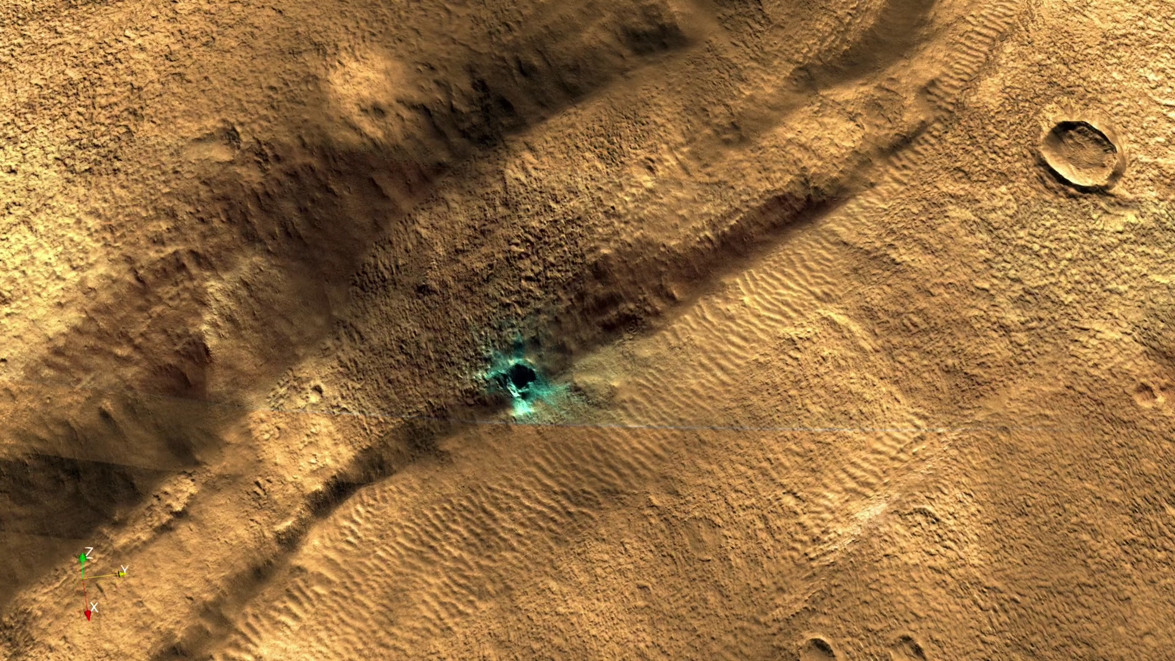
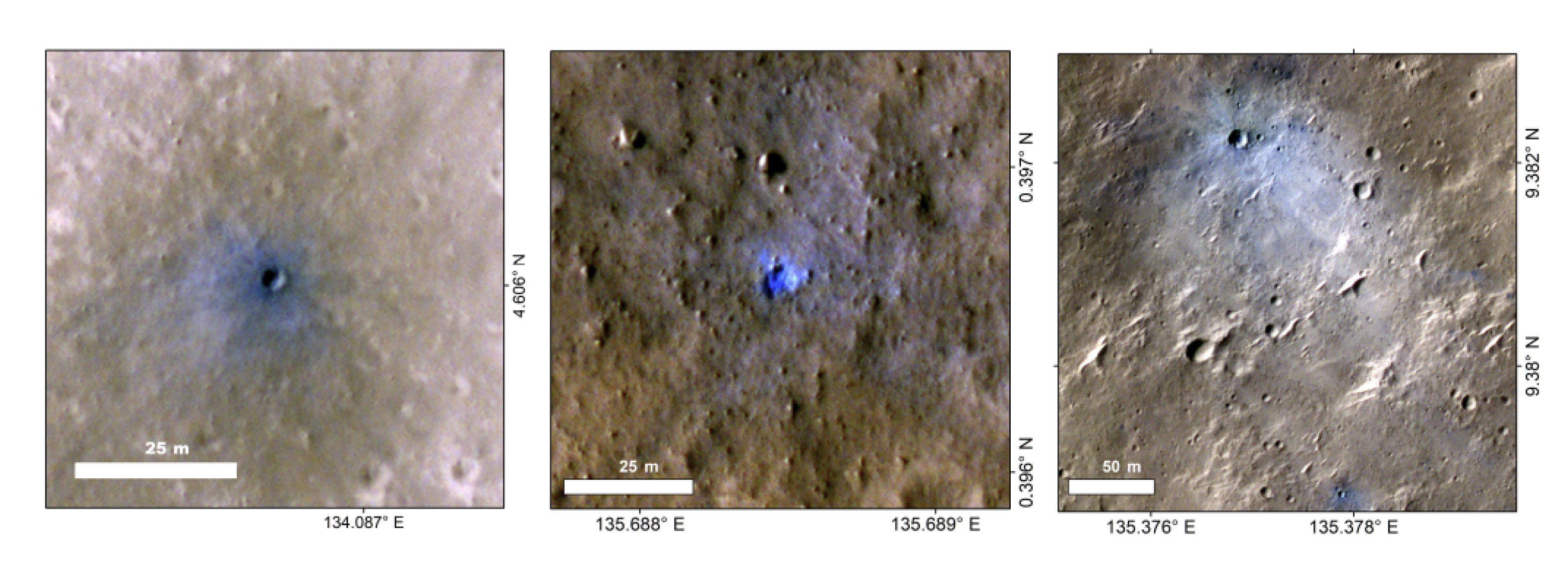
Meteorites frequently collide with Mars, creating its distinctive cratered landscape. This is because the Red Planet, compared to Earth, has a thin atmosphere and is closer to the asteroid belt in our solar system. Now, as part of NASA's InSight mission, with input from the Marsquake Service and ETH Zurich, researchers have been able to record the impacts of four meteorites using the seismometer on board the mission's spacecraft. These are the first measurements of ground tremors caused by such impacts on Mars.
Read more...The key to the discovery was a meteorite that penetrated the Martian atmosphere on 5 September 2021. Upon entry it split into at least three parts, which left craters when they hit the planet's surface. The craters are located in the area of Elysium Planitia, approximately 100 km from the InSight station, confirmed in a flight by NASA's Mars Reconnaissance Orbiter. The three impacts and the resulting pressure waves produced tremors that show up clearly in the seismic data. The researchers then analysed earlier seismic recordings again and discovered three more meteorite impacts. They suspect that other impacts have also occurred in the past, but these are hidden in the background noise of the seismic signals. This noise is caused by strong winds and seasonal changes in the atmosphere.
Meteorite impacts on the surface of Mars reveal a lot about the history of the Red Planet. By tracing how often craters of different sizes are created, it is possible to determine retrospectively how and over what period the present-day Martian surface formed. Drawing on satellite images as well, the trajectory of a meteorite and the size of the shock wave triggered can also be reconstructed. The findings are set out in a recent article in the journal Nature Geoscience.
2022-09-10
[Available in DE / FR] Erdbeben der Magnitude 4.7 im Elsass in weiten Teilen der Schweiz deutlich verspürt
Am späten Samstagnachmittag des 10. September 2022 hat sich um 17:58 Uhr im Elsass, in der Nähe der Ortschaft Sierentz (F) etwa 15 km nördlich von Basel, ein Erdbeben der Magnitude 4.7 ereignet. Das Beben fand in einer Tiefe von ca. 12 km statt. Leichte Schäden sind bei einem Erdbeben dieser Stärke in der Nähe des Epizentrums möglich. Die Erschütterungen des Bebens waren in der gesamten Nordschweiz deutlich zu spüren. In der ersten Stunde nach dem Beben sind beim Schweizerischen Erdbebendienst an der ETH Zürich tausende Meldungen aus der Bevölkerung eingegangen. Die Webseiten des SED waren zum Teil überlastet. Eingereichte Verspürtmeldungen können wir auswerten, auch wenn beim Absenden eine Fehlermeldung angezeigt wurde, wie von einigen Nutzer und Nutzerinnen berichtet wurde.
Read more...Rund zehn Minuten nach dem Hauptstoss, um 18:07 (Lokalzeit), ereignete sich bereits ein erstes Nachbeben mit einer Magnitude von 2.8, das in der Nähe des Epizentrums ebenfalls verspürt werden konnte. Die Beben stehen in tektonischem Zusammenhang mit dem seismisch aktiven Rheingraben, der sich zwischen den Vogesen und dem Schwarzwald in nord-südlicher Richtung erstreckt. Erdbeben sind in dieser Region nichts Aussergewöhnliches, wobei ein Beben dieser Magnitude in dieser Region nur etwa alle zehn bis zwanzig Jahre auftritt. In der Region Sierentz (F) hat es im Jahr 1980 eine Sequenz von Erdbeben gegeben, das Stärkste hatte eine Magnitude von 4.4.
Es ist wahrscheinlich, dass sich in den nächsten Stunden und Tagen weitere, möglicherweise auch spürbare Nachbeben ereignen werden. Nach jedem Erdbeben besteht zudem eine kleine Wahrscheinlichkeit von 3 bis 5 Prozent, dass sich ein Beben mit einer ähnlich grossen oder gar grösseren Magnitude ereignet. Zwischen den beiden Erdbeben, die sich am Samstagmorgen im Wallis ereignet haben und vereinzelt auch verspürt wurden, und den Beben im Elsass besteht unserer Einschätzung nach keine Verbindung.
![[Available in DE / FR] Erdbeben der Magnitude 4.7 im Elsass in weiten Teilen der Schweiz deutlich verspürt](/export/sites/sedsite/about-us/.galleries/img_news_2022/Erdbeben-Elsass_1092022_2.png_2063069299.png "[Available in DE / FR] Erdbeben der Magnitude 4.7 im Elsass in weiten Teilen der Schweiz deutlich verspürt")
2022-09-07
[Available in DE] Verspürtes Nachbeben bei Triesenberg (FL)
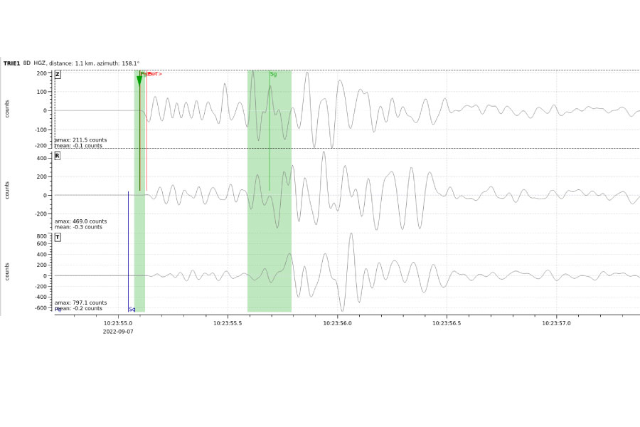
Am Mittwoch, 7. September 2022, hat sich um 12:23 Uhr (Lokalzeit) bei Triesenberg (FL) südöstlich von Vaduz in einer relativ geringen Tiefe von ungefähr 2 km ein Erdbeben der Magnitude 2.4 ereignet. Bei diesem Erdbeben handelt es sich um ein weiteres verspürtes Nachbeben des Hauptbebens mit einer Magnitude von 3.9, das sich am 1. September 2022 am gleichen Ort ereignet hat (siehe Aktuellbeitrag vom 01.09.2022). Beim Schweizerischen Erdbebendienst (SED) an der ETH Zürich gingen zum bisher stärksten Nachbeben vom 7. September mehr als 100 Verspürtmeldungen aus der nahen Umgebung ein, mehrheitlich aus den Orten Vaduz, Triesenberg und Triesen. Bei einem Erdbeben dieser Stärke sind in der Regel keine Schäden zu erwarten.
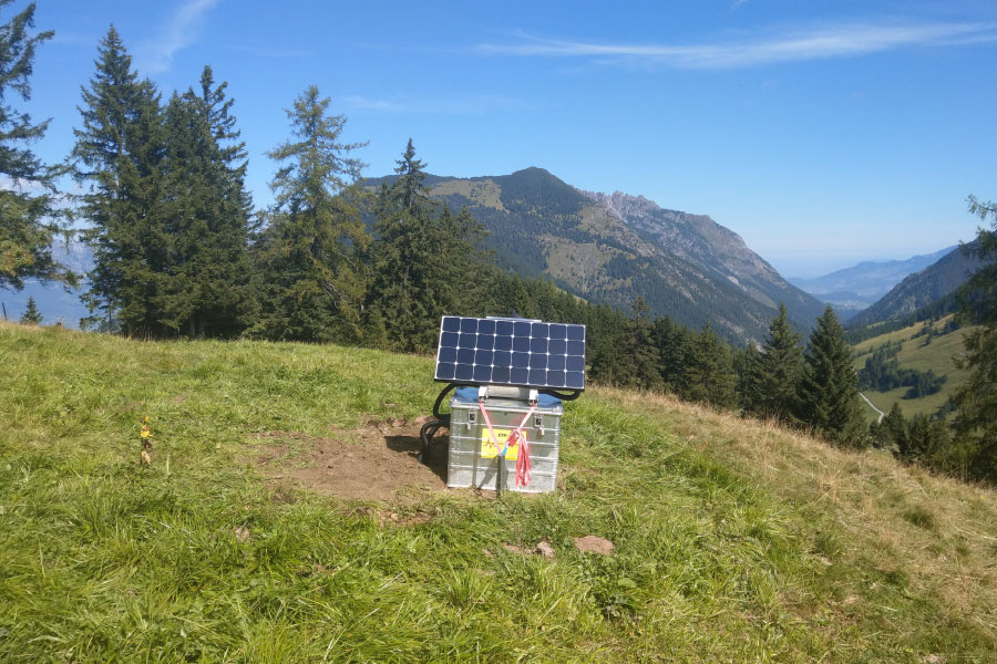
Solche Nachbeben sind keine Seltenheit. Aufgrund dessen werden vom Schweizerischen Erdbebendienst nach einem breit verspürten Beben oft mobile Nachbebenstationen in der Nähe des Hauptbebens installiert. Diese Messinstrumente erlauben es, aktuelle Erdbebensequenzen besser zu erfassen und wissenschaftlich zu untersuchen. Im Bild oben sieht man die Nachbebenstation beim Berggasthaus Sücka sowie die registrierte Bodengeschwindigkeit, welche dieses Nachbeben verursacht hat.
2022-09-01
[Available in DE] Clearly felt earthquake near Triesenberg (FL)
Der Schweizerische Erdbebendienst (SED) an der ETH Zürich hat am Donnerstag, 1. September 2022, um kurz vor 14 Uhr Ortszeit bei Triesenberg (FL) südöstlich von Vaduz ein Erdbeben der Magnitude 3.9 registriert. Das Beben ereignete sich in relativ geringer Tiefe von etwa 2 km unter der Oberfläche und wurde insbesondere in der Nähe des Epizentrums stark verspürt. Aufgrund der geringen Tiefe sind lokal kleinere durch das Erdbeben verursachte Risse im Verputz möglich, grösseren Schäden sind jedoch nicht zu erwarten.
In den ersten Minuten nach dem Beben sind beim SED über 700 Verspürtmeldungen zu dem Beben eingegangen. Die meisten Meldungen kamen von Personen, die sich in weniger als 30 km zum Beben aufhielten, aber auch von etwas weiter entfernten Orten wie St. Gallen oder Chur. Vereinzelte Meldungen gingen zudem aus den Regionen Schaffhausen, Zürich und Luzern ein.
Etwa 20 Sekunden vor dem Beben gab es ein Vorbeben der Stärke 2.1. Bisher gab es nur ein grösseres Nachbeben, das im engeren Epizentralgebiet deutlich verspürt wurde: am nachfolgenden Morgen, den 2. September um 6:44 Uhr mit einer Magnitude von 2.2. Es ist aber durchaus möglich, dass sich in den nächsten Stunden und Tagen weitere auch spürbare Nachbeben ereignen. Es besteht zudem eine kleine Wahrscheinlichkeit, dass sich ein grösseres Beben ereignet.
Read more...Das letzte Beben mit einer vergleichbaren Magnitude von 4.1 in der Schweiz ereignete sich bei Porrenturry (JU) im Dezember 2021. Beben dieser Stärke sind in der Schweiz und im grenznahen Umland in etwa einmal pro Jahr zu erwarten. Das letzte in der Region weiträumig spürbare Erdbeben ereignete sich am 25. Oktober 2020 in der Nähe von Elm (GL) mit einer Magnitude von 4.3. In Sargans (SG) bebte die Erde mit einer Magnitude von 4.1 am 12. Dezember 2013 gefolgt von einem ebenfalls deutlich spürbaren Nachbeben mit einer Stärke von 3.7 am 27. Dezember 2013. 2009 erschütterte zudem ein Beben mit einer Magnitude von 4.1 mit Epizentrum bei Buchs die Region. Historisch sind zwei grössere Schadenbeben in der Region Gams, Grabs, Wildhaus bekannt, die sich in den Jahren 1795 und 1796 ereignet haben. Kleinere Schadenbeben trafen die Region in den Jahren 1881 und 1898.
Das St. Galler Rheintal gehört zu den Gebieten mit erhöhter Erdbebengefährdung der Schweiz. Die Wahrscheinlichkeit für stärkere Erdbeben ist dort höher als im Mittelland, aber geringer als im Wallis oder in der Region Basel. Starke Erdbeben können in der Schweiz im Prinzip jederzeit und überall auftreten, Beben mit Magnitude 6 oder mehr sind etwa einmal innerhalb von 50 bis 150 Jahren zu erwarten. Eine erdbebensichere Bauweise ist der beste Schutz vor Erdbeben.
![[Available in DE] Clearly felt earthquake near Triesenberg (FL)](/export/sites/sedsite/home/.galleries/img_news_2021/Vaduz-20220901english.png_2063069299.png "[Available in DE] Clearly felt earthquake near Triesenberg (FL)")
2022-07-28
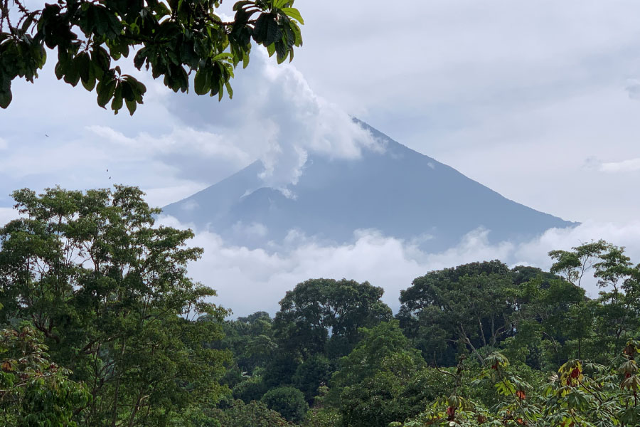
Using seismometers to monitor Santiaguito volcano in Guatemala
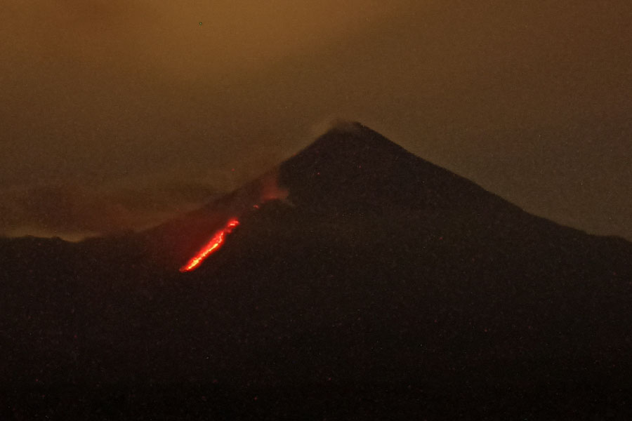
Where there are volcanoes, the earth shakes frequently. In these regions, earthquakes often herald impending volcanic unrest. Both earthquakes and volcanoes occur mainly at the boundaries of shifting tectonic plates. One typical example is Guatemala: the country, located in Central America and sitting on the middle America Trench, has 43 volcanic systems, 25 of which are considered active and a subset of three (Pacaya, Fuego and Santiaguito) produce daily eruptive activity. Like earthquakes, volcanic activity and associated hazards are hard to predict and require close monitoring. This typically includes a seismic network that can measure background activity and allows response to events in real-time, potentially providing warnings to the local population before volcanic hazards threaten their lives. The Swiss Seismological Service (SED) at ETH Zurich is currently just involved in such a project in Guatemala.
Read more...With the support of the Swiss Agency for Development and Cooperation (SDC) and in collaboration with the Guatemalan NGO Vivamos Mejor, the SED is supporting the Guatemalan National Institute for Seismology, Vulcanology, Meteorology and Hydrology (INSIVUMEH) to establish seismic monitoring of Santiaguito, one of Guatemala’s active volcanoes. This collaboration is part of a major SDC project that aims to mitigate the risk from Santiaguito to the local population. Located in southwest Guatemala, Santiaguito is considered to be the volcano with the highest risk in Central America. Tracking seismic activity under the volcano with high precision can allow scientists to better predict eruptive phases. Additional major hazards at Santiaguito also include violent mudflows (lahars) and catastrophic pyroclastic flows, which contain a mixture of rocks, gas, ash and travel very rapidly. These two hazards pose a high risk for the surrounding communities.
INSIVUMEH is currently installing a seismic network on and around the volcano. The role of the SED team is first to help ensure a successful network deployment and data processing. Therefore, researchers from the SED travelled to Guatemala at the end of June to review plans and progress for the seismic network and associated processing. In addition, the team had the opportunity to visit the volcano and better understand the hazards it poses to local communities. The network is expected to be completed this summer. By the end of the year, an event catalogue will become available with examples of seismic records of lahar flows and volcano-tectonic earthquakes. Through previous research projects in Central America to build Earthquake Early Warning (EWARNICA / ATTAC), the SED has established a strong relationship with INSIVUMEH and can rely on previous experience in this region and in Guatemala in particular.
Once the network is operational, the SED team will work to develop scientific tools to improve the monitoring of Santiaguito. During the two-year project, they aim to build a velocity model that will help improve our understanding of volcano-tectonic seismicity and allow the tracking of evolving seismicity. Furthermore, a method will be developed to rapidly detect lahar flows on the volcano's upper slopes so that warnings may be provided to communities downstream.
2022-07-09
[Available in DE / FR] Beben in Süddeutschland in der Nordschweiz verspürt
Ein Beben der Magnitude 4.2 ereignete sich am Samstag, 9. Juli 2022, um 13:47 Uhr (Ortszeit) bei Hechingen, nordwestlich von Albstadt, auf der Schwäbischen Alb, etwa 65 km von der Schweizer Grenze entfernt, in einer Tiefe von etwa 8 km. Das Beben wurde in der Nordschweiz verbreitet verspürt, bis etwa Luzern (ca. 150 km Entfernung). Dies belegen die mehr als 330 Verspürtmeldungen, die in den ersten 30 Minuten nach dem Beben beim Schweizerischen Erdbebendienst (SED) an der ETH Zürich eingegangen sind.
Read more...Das Gebiet der Schwäbischen Alb ist eine bekannte seismische Zone, die wiederholt von Erdbeben erschüttert wird. So ereignete sich 1978 ein Erdbeben der Magnitude 5.7, das circa 8'500 Gebäude beschädigte und 25 Personen verletzte. Bei einem Erdbeben der Stärke 4.2 wie am 9. Juli 2022 können lediglich in der Nähe des Epizentrums vereinzelt leichte Schäden an empfindlichen Gebäuden, die auf lockerem Boden stehen, auftreten.
![[Available in DE / FR] Beben in Süddeutschland in der Nordschweiz verspürt](/export/sites/sedsite/home/.galleries/img_news_2017/SED_Weihnachtskarte_2017_Web.jpg_2063069299.jpg "[Available in DE / FR] Beben in Süddeutschland in der Nordschweiz verspürt")
2022-05-11
Largest Marsquake observed since the beginning of the NASA InSight mission
On 4 May 2022, NASA’s InSight Mars lander detected the largest quake ever observed on another planet: an estimated magnitude 5 event. The largest previously recorded quake on the red planet was a magnitude 4.2 detected on 25 August 2021.
The recent M5 event, labelled S1222a as the event occurred on the Martian day Sol 1,222 of the mission, was detected by a graduate student at ETH Zurich on duty at the time when the signals were analysed on Earth. It was not hard to spot though - the event is so large it has by far the strongest signal since the beginning of the mission, despite the event occurring in a season where almost no marsquakes are observed due to high winds disturbing the signal.
Read more...A magnitude 5 quake is a medium-size quake compared to those felt on Earth, but it’s close to the upper limit of what scientists hoped to see on Mars during InSight’s mission. The science team will need to study this new quake further before being able to provide details such as its location, the nature of its source, and what it might tell us about the interior of Mars.
Shortly after recording the event, Insight went into safe mode - where the spacecraft suspends all but the most essential functions to save energy - due on-going issues with low power associated with mounting dust on the solar panels. It is possible that S1222a is one of the very last events Insight will record. With over 1,300 events already catalogued, it is most likely Mars saved the best until last.
InSight is equipped with a highly sensitive seismometer provided by Centre National d’Études Spatiales (CNES) in France, and a digitizer provided by ETH Zurich in Switzerland. The ETH Zurich team in close collaboration with the Swiss Seismological Service also coordinates Insight’s Marsquake Service that screen the data for seismic energy, characterize marsquakes and curate the marsquake catalogue.

2022-04-28
New earthquake assessments available to strengthen preparedness in Europe
During the 20th century, earthquakes in Europe accounted for more than 200,000 deaths and over 250 billion Euros in losses (EM-DAT). Comprehensive earthquake hazard and risk assessments are crucial to reducing the effects of catastrophic earthquakes. The newly released update of the earthquake hazard model and the first earthquake risk model for Europe are the basis for establishing mitigation measures and making communities more resilient. They significantly improve the understanding of where strong shaking is most likely to occur and what effects future earthquakes in Europe will have. The development of these models was a joint effort of seismologists, geologists, and engineers across Europe with the leading support of members from the Swiss Seismological Service and the Group of Seismology and Geodynamics at ETH Zurich. The research has been funded by the European Union’s Horizon 2020 research and innovation programme.
Read more...Earthquakes cannot be prevented nor precisely predicted, but efficient mitigation measures informed by earthquake hazard and risk models can significantly reduce their impacts. The 2020 European Seismic Hazard and Risk Models offer comparable information on the spatial distribution of expected levels of ground shaking due to earthquakes, their frequency as well as their potential impact on the built environment and on people’s wellbeing. To this aim, all underlying datasets have been updated and harmonised – a complex undertaking given the vast amount of data and highly diverse tectonic settings in Europe. Such an approach is crucial to establish effective transnational disaster mitigation strategies that support the definition of insurance policies or up-to-date building codes at a European level (e.g. Eurocode 8) and at national levels. In Europe, Eurocode 8 defines the standards recommended for earthquake-resistant construction and retrofitting buildings and structures to limit the impact due to earthquakes. Open access is provided to both, the European Seismic Hazard and Risk Models, including various initial components such as input datasets.
The updated earthquake hazard model benefits from advanced datasets
Earthquake hazard describes potential ground shaking due to future earthquakes and is based on knowledge about past earthquakes, geology, tectonics, and local site conditions at any given location across Europe. The 2020 European Seismic Hazard Model (ESHM20) replaces the previous model of 2013.
The advanced datasets incorporated into the new version of the model have led to a more comprehensive assessment of the earthquake hazard across Europe. In consequence, ground shaking estimates have been adjusted, resulting in lower estimates in most parts of Europe, compared to the 2013 model, and therewith in the case of Switzerland closer to the national model. With the exception of some regions in western Turkey, Greece, Albania, Romania, southern Spain, and southern Portugal where higher ground shaking estimates are observed. The updated model also confirms that Turkey, Greece, Albania, Italy, and Romania are the countries with the highest earthquake hazard in Europe, followed by the other Balkan countries. But even in regions with low or moderate ground shaking estimates, damaging earthquakes can occur at any time.
Furthermore, specific hazard maps from Europe’s updated earthquake hazard model will serve for the first time as an informative annex for the second generation of the Eurocode 8. Eurocode 8 standards are an important reference to which national models may refer. Such models, when available, provide authoritative information to inform national, regional, and local decisions related to developing seismic design codes and risk mitigation strategies. Integrating earthquake hazard models in specific seismic design codes helps ensure that buildings respond appropriately to earthquakes. These efforts thus contribute to better protect European citizens from earthquakes.
Main drivers of the earthquake risk are older buildings, high earthquake hazard, and urban areas
Earthquake risk describes the estimated economic and humanitarian consequences of potential earthquakes. In order to determine the earthquake risk, information on local soil conditions, the density of buildings and people (exposure), the vulnerability of the built environment, and robust earthquake hazard assessments are needed. According to the 2020 European Seismic Risk Model (ESRM20), buildings constructed before the 1980s, urban areas, and high earthquake hazard estimates mainly drive the earthquake risk.
Although most European countries have recent design codes and standards that ensure adequate protection from earthquakes, many older unreinforced or insufficiently reinforced buildings still exist, posing a high risk for their inhabitants. The highest earthquake risk accumulates in urban areas, such as the cities of Istanbul and Izmir in Turkey, Catania and Naples in Italy, Bucharest in Romania, and Athens in Greece, many of which have a history of damaging earthquakes. In fact, these four countries alone experience almost 80% of the modelled average annual economic loss of 7 billion Euros due to earthquakes in Europe. However, also cities like Zagreb (Croatia), Tirana (Albania), Sofia (Bulgaria), Lisbon (Portugal), Brussels (Belgium), and Basel (Switzerland) have an above-average level of earthquake risk compared to less exposed cities, such as Berlin (Germany), London (UK), or Paris (France).
Developing the models is a joint effort – the role of ETH Zurich
A core team of researchers from different institutions across Europe, including the leading support of members from ETH Zurich, worked collaboratively to develop the first openly available Seismic Risk Model for Europe and to update Europe’s Seismic Hazard Model. They have been part of an effort that started more than 30 years ago and involved thousands of people from all over Europe. These efforts have been funded by several European projects and supported by national groups over all these years.
Researchers from the Swiss Seismological Service (SED) and the Group of Seismology and Geodynamics at ETH Zurich led many of these projects. The SED is also home to EFEHR (European Facilities for Earthquake Hazard and Risk). EFEHR is a non-profit network dedicated to the development and updating of earthquake hazard and risk models in the European-Mediterranean region. ETH Zurich thus holds a central hub function for data collection and processing, open access to earthquake hazard and risk models including all basic data sets, and knowledge exchange.

2022-04-28
What does the publication of European seismic hazard and risk models mean for Switzerland?
Spring 2022 saw the release of an updated seismic hazard model and the first open-access seismic risk model for Europe. The models describe where, how often and how severely ground shakings triggered by earthquakes are expected to occur as well as their possible impacts on buildings and their occupants (see press release). In contrast to national models, the European models are harmonised across national borders. As such, they are particularly useful in supporting transnational assessments and associated efforts to mitigate the potential effects of earthquakes.
Read more...National construction standards unlikely to change
One important aspect of earthquake mitigation that relies on hazard models is the development of construction standards for earthquake-resistant structures. In Switzerland, this task is the responsibility of the Swiss Society of Engineers and Architects (SIA), which takes as its basis the national hazard assessment prepared by the Swiss Seismological Service at ETH Zurich, last updated in 2015. This is standard practice in countries and regions for which comprehensive hazard assessments are available. The reason for this is that national models depict local conditions with greater precision and in a higher resolution than European models. Nevertheless, the relevant SIA committee will study the new European model closely and analyse possible differences vis-à-vis the national model. However, this is not expected to result in any changes to the currently applicable SIA standards for earthquake-resistant construction (SIA 261 Actions on Structures).
Work under way on national seismic risk model
In contrast to seismic hazard, Switzerland does not yet have a national model for seismic risk. The SED is currently developing such a model in collaboration with the Federal Office for the Environment and the Federal Office for Civil Protection. Due to be published next year, it will show in great detail the damage that can be expected to occur in Switzerland as a result of earthquakes. As with the seismic hazard model, the national seismic risk model will reflect the specific characteristics of Switzerland more accurately than the European model and will therefore serve as the primary reference for Switzerland-wide risk analyses. However, the European model is helpful when it comes to making risk comparisons between countries. It also offers a valuable basis for comparison for the national model.
European results confirm national hazard analysis and provide initial indications of high-risk regions
Initial analyses by the SED suggest that the European seismic hazard assessment differs only minimally from the national assessment. There is currently no reference for seismic risk, but in the European model Basel and Geneva stand out as places at particularly high risk in Switzerland. This is hardly surprising in the case of Basel, as all relevant seismic risk factors come together there: a high density of residents and property, a high seismic hazard and many vulnerable buildings. Compared with Basel, Geneva has a lower seismic hazard. However, a fault zone in the French Alps plays a key role in the European risk model as a possible source of more distant but potentially large earthquakes. As with Basel, there is also a high density of residents and property and a vulnerable building stock, much of which is built on soft subsoil that is not good for earthquakes (sedimentary basin). Furthermore, on the map in the European model, the core zone in Geneva lies in a single cell, whereas in Zurich, which has similar conditions, it is spread across three cells. From a purely visual point of view, therefore, the risk appears greater for Geneva than for Zurich, for example.
The fact that other urban or particularly vulnerable Swiss areas do not show up more strongly in the European seismic risk model is mainly due to two factors. Firstly, Swiss cities tend to be small by European standards and are therefore at less risk than other large urban areas. Secondly, the results are normalised with gross domestic product (GDP). In other words, the risk assessment takes into account a country's ability to mitigate the effects of an earthquake. In 2021, Switzerland had the second highest GDP of all European countries after Luxembourg. The Swiss model will present the seismic risk landscape here in a more nuanced way, not only because it is not subject to such a weighting but also because it incorporates additional datasets, such as more detailed ground reinforcement maps as well as building vulnerability models developed specifically for Switzerland.

2022-01-26
Earthquakes in Switzerland in 2021
Last year, the Swiss Seismological Service (SED) at ETH Zurich recorded just over 1,100 earthquakes in Switzerland and surrounding areas. This figure is slightly down on previous years, due in part to the fact that no major earthquake swarms occurred in 2021. At the same time, the number of quakes having a magnitude of 2.5 to 4.1 was above the long-term average.
Since 1975, an average of around one earthquake with a magnitude of 4.0 and above has occurred each year; 2021 saw a higher than average number of such quakes, with three striking in that year alone. The first quake at this magnitude shook the area around the Furka Pass on 1 July last year. Its impact was mainly felt to the north as far as Zurich and Schaffhausen, as evidenced by the more than 900 felt reports received. By contrast, the magnitude 4.1 earthquake that occurred on 5 October near Arolla (Valais) was reported by only a few people, almost exclusively within the canton itself. This quake was part of an earthquake sequence that became active again in September 2020. The same area had already experienced a similarly strong quake in 1996. In Valais, the earthquake swarms near Saint Léonard and the Sanetsch Pass continued to be active and also resulted in some noticeable quakes so did the one in canton of Vaud near Les Diablerets.
Read more...The third quake having a magnitude greater than 4.0 occurred on 25 December in the Ajoie region (Jura). It was primarily felt in the Jura, though there were some reports from the western Swiss Plateau as far as Lausanne, Bern, Lucerne and Zurich. The main quake with a magnitude of 4.1 was followed by two equally noticeable aftershocks having magnitudes of 3.5 and 3.2. While Valais is well known as an earthquake region, the Jura quakes make it clear that all of Switzerland is earthquake country. Although the last quake of this magnitude in the Ajoie region occurred more than a century ago, making them rather rare, they are not unexpected.
As a long-term average, 24 quakes with a magnitude of 2.5 or more occur in and around Switzerland each year. In 2021, this number was slightly higher (32). Felt reports from members of the public were received for 52 of these quakes, with 10 each eliciting observations from over 100 people. The SED received the most reports from the public (approx. 1,100) for the magnitude 2.8 and 3.2 earthquakes occurring near Bern on 3 February and 15 March, mainly owing to the high population density in the vicinity of the hypocentre. Quakes in adjoining parts of neighbouring countries are also significant for determining Switzerland's seismic hazard. An earthquake with a magnitude of 4.4 that hit Bergamo (Italy) on 18 December was felt mainly in Ticino and some parts of Valais, Grisons and Central Switzerland. The SED received around 1,000 reports about this quake.
In addition to natural earthquake activity, the SED's seismic network also records tremors triggered by humans. Though most of these are explosions, some are man-made earthquakes. Physically speaking, the latter are no different from natural quakes but there are reliable indicators as to whether a quake is man-made (e.g. its exact place of origin in the subsurface, the temporal and spatial correlation with the stress changes sparked by humans). As such, it is vital that these interventions be monitored through a dense network of seismic stations.
To this end, the SED has expanded its network at various sites in Switzerland. The SED currently supports the seismic monitoring of five deep geothermal projects in Switzerland as well as ETH Zurich's BedrettoLab. The SED also runs a condensed seismic network in northeastern Switzerland on behalf of Switzerland's National Cooperative for the Disposal of Radioactive Waste (Nagra) with a view to better understanding the subsurface and seismic activity at potential sites for final repositories of spent nuclear fuel. More than 200 stations throughout Switzerland continuously transmit their measurement data to the SED, making it possible to record all earthquakes having a magnitude of 1.5 and above – a value well below the perception threshold. In areas where it is particularly dense, the seismic network can record even smaller earthquakes.

2022-01-18
Waves from Tonga volcanic eruption have already circled Earth twice
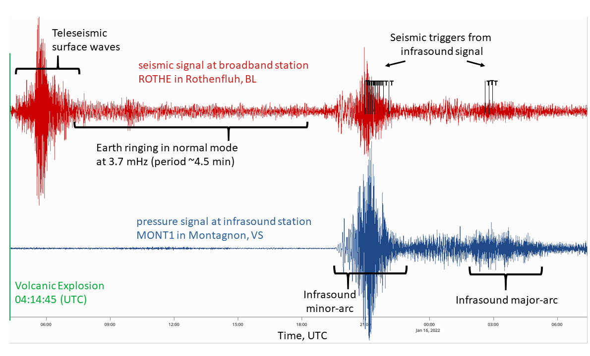
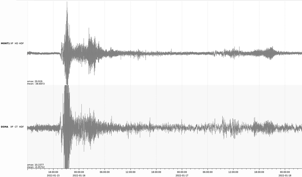
The massive submarine eruption of the Hunga-Tonga-Hunga-Ha'apai volcano in the South Pacific on 15 January 2022 was registered by the seismic stations of the Swiss Seismological Service at ETH Zurich (SED). The volcanic explosion began at 05:14 Swiss time and generated seismic waves equivalent to a magnitude 5.8 earthquake. Seismic body waves reached the Swiss seismic network around 20 minutes later, having passed directly through the Earth. Body waves propagate at speeds of 5–10 km/second (36,000 km/h). Another 30 minutes later, seismic surface waves – which travel more slowly – also reached Switzerland. The Swiss network continued to record the Earth 'ringing' in normal mode for more than 12 hours after the surface waves had subsided. This is where the Earth vibrates at characteristic frequencies determined by its internal structure. These vibrations, with a period of approximately 4.5 minutes, were also observed after the eruption of the Philippine volcano Mount Pinatubo in 1991.
Read more...Such volcanic explosions also create pressure waves in the atmosphere, as described in this MeteoSwiss blog (in German). Infrasound waves, which have frequencies below the lower limit of human audibility (between approximately 15 Hz and 0.001 Hz), are only slightly attenuated in the atmosphere and can be measured over very long distances. Infrasound travels at a speed of around 1,200 km/h. These waves showed up clearly on the SED's highly sensitive broadband monitoring stations and on SED-operated infrasound sensors from around 20:30 Swiss time, a little over 15 hours after the seismic waves reached Switzerland. The dispersion of these infrasound waves (i.e. the way their propagation velocity depends on their frequency) can also be clearly seen, with low frequencies propagating slightly faster and arriving first, followed by progressively higher frequencies. An initial period of strong signals lasting a good two hours was caused by the waves that reached us directly. Around five hours later, the signals that propagated in the opposite direction can be seen, with significantly smaller amplitudes. Another spike was observed on the morning of 17 January as the waves circled the Earth for a second time. The infrasound signals caused a number of false seismic triggers during automatic data processing at the seismic monitoring stations.