| Local time | 2024-03-29 10:33:29 |
|---|---|
| UTC Time | 2024-03-29 09:33:29 |
| Event Type | quarry blast |
| Latitude / Longitude | 46.80 / 6.36 |
| Swiss Coordinates | 517451 / 184100 |
| Magnitude | 1.8 |
| Magnitude Type | MLhc |
| Location | Vallorbe VD |
| Depth [km] | - |
| Location Type | manual |
| Agency | SED |
| Last Update | 29-03-2024 10:51:12 |
| Danger level | 1 (as defined by federal agencies with responsibility for natural hazards) |
| Origin ID & Metadata | smi:ch.ethz.sed/sc20ag/Origin/NLL.20240329105109.887098.130040 |
|
GSE 2.1 provisional format |
|---|
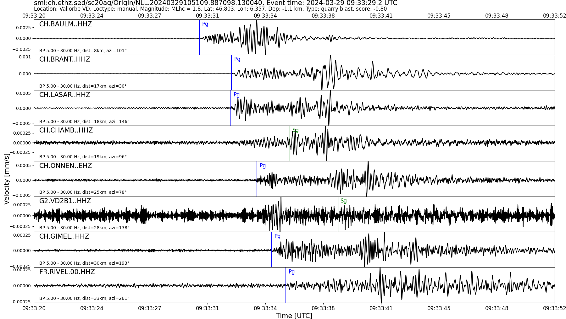
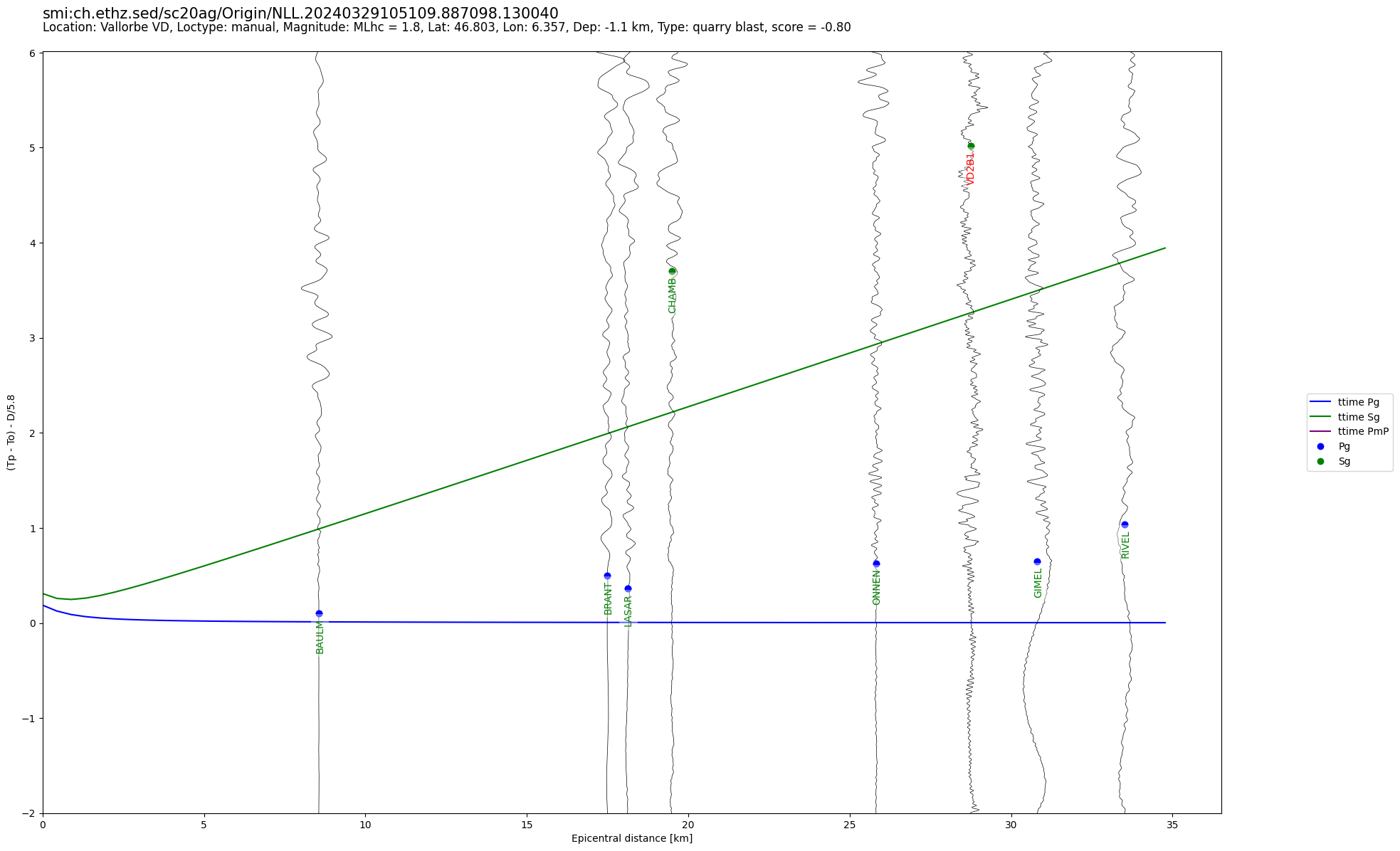
| BEGIN GSE2.1 MSG_TYPE DATA MSG_ID 2024/03/29_093744509 CHE_NDC DATA_TYPE BULLETIN GSE2.1:short Reviewed Event Bulletin (REB) of the CHE_NDC for March 29, 2024, 09:33:29.288 EVENT 2024/03/29_093329288 VALLORBE VD Date Time Err RMS Latitude Longitude Smaj Smin Az Depth Err Ndef Nsta Gap mdist Mdist Qual Author OrigID 2024/03/29 09:33:29.29 0.27 46.8031 6.3708 38447.9 2201.6 127 -1.0 15.9 9 9 192 0.07 0.77 a i uk SED -------- Magnitude Err Nsta Author OrigID MLhc 2.1 0.3 5 SED -------- Sta Dist EvAz Phase Time TRes Azim AzRes Slow SRes Def SNR Amp Per Qual Magnitude ArrID BAULM 0.07 103.6 P 09:33:30.960 0.0 ___ 3906.3 a__ MLhc 2.3 -------- BRANT 0.15 28.8 P 09:33:32.825 0.0 ___ 727.9 a__ MLhc 2.1 -------- LASAR 0.16 150.5 P 09:33:32.705 -0.1 ___ 601.6 a__ MLhc 2.1 -------- CHAMB 0.17 97.2 P 09:33:34.385 1.3 ___ a__ -------- ONNEN 0.22 77.7 P 09:33:34.295 0.1 ___ 274.8 a__ MLhc 1.8 -------- GIMEL 0.28 196.8 P 09:33:35.490 0.1 ___ 121.5 a__ MLhc 1.6 -------- RIVEL 0.31 261.9 P 09:33:41.650 5.9 ___ a__ -------- EPAUV 0.74 43.9 P 09:33:45.600 1.5 ___ a__ -------- SALAN 0.77 149.0 P 09:33:45.314 0.5 ___ a__ -------- STOP |