Premere il tasto Tab per attivare la modalità screen reader.
  • Pagina iniziale
  • Lingua
  • Menu
  • Cerca
  • Lingua facile
  • Contenuto
  • Contatto
MENU
Logo Servizio Sismico Svizzero ETH logo
DE EN FR IT
Lingua facile
DE EN FR IT
×
  • Pagina iniziale
  • Terremoti
    • Svizzera
    • Europa
    • Mondo
    • Mappe
    • Segnalate un terremoto
    • Cosa fare?
      • Raccomandazioni di comportamento
      • Terremoto all’estero
      • Edilizia antisismica
      • Assicurazione antisismica
    • Sempre informati
      • Allerta
      • Ricevere informazioni
      • Stime rapide dei danni
      • ShakeMap
      • Annunci di terremoto
  • Sorveglianza
    • Misurare i terremoti
    • Rete nazionale svizzera
    • Speciali reti
      • Panoramica
      • Geotermia Haute-Sorne
      • Geotermia Yverdon-les-Bains
      • Geotermia bacino di Ginevra
      • Geotermia Vinzel
      • Depositi profondi Svizzera nordorientale
      • Monitoraggio del foro di trivellazione Basilea-1
      • Progetti passati
    • Sismogrammi in tempo reale
      • Ultimi 5 minuti
      • Ultimi 20 minuti
      • Ultime 2 ore
      • Ultime 24 ore
    • Realizzazione di una stazione di registrazione
    • Monitoraggio del Trattato sul divieto degli esperimenti nucleari
  • Svizzera terra di sismi
    • Panoramica
    • Pericolosità
      • Panoramica
      • Componenti
      • Modello di pericolosità sismica
    • Rischio
      • Panoramica
      • Componenti
      • Modello di rischio sismico
      • Strumento di rilevamento del rischio sismico
    • Scenari sismici
    • Regioni sismiche
      • Grigioni
      • Vallese
      • Basilea
    • Terremoti storici
      • I dieci più forti
      • Basilea 1356
      • Sierre 1946
    • Sciami sismici
      • Introduzione
      • Sarnen 1964
      • Diemtigen 2014 - 2015
  • Sapere
    • Cause dei terremoti
      • In genere
      • In Svizzera
      • In Europa
      • Sismi indotti
    • Conseguenze dei terremoti
    • Precursori sismici
    • Portali web e dati sui terremoti
      • Panoramica
      • Software per il monitoraggio dei terremoti
      • Informazioni sulle stazioni
      • Cataloghi dei terremoti
      • Dati sulle forme d’onda
      • FDSN web services
      • Allerta precoce sui terremoti
      • ShakeMap
      • Archivio
    • Geotermia & terremoti
      • Geotermia in breve
      • Forme di energia geotermica
      • Geotermia & terremoti indotti
      • Misure per mitigare sismicità indotta
      • Geotermia in Svizzera
      • Geotermia e il SED
      • Competente consulenza sismologica (GEOBEST2020+)
      • Fracking
    • Scosse su Marte
    • Domande più frequenti (FAQ)
  • Ricerca & insegnamento
    • Progetti
    • Pubblicazioni
    • Insegnamento & formazione
    • Schatzalp Workshop 2025
  • Attualità & publicazioni
    • Articoli attuali
      • 2025
      • 2024
      • Archivio
    • Per le scuole
    • Opuscoli informativi
    • Quiz
    • Video e giochi
    • Simulatore sismico
    • Letteratura sui terremoti
  • Chi siamo
    • Contatti & richieste dei media
    • Profilo
      • Compiti & organizzazione
      • Storia
      • Indipendenza & trasparenza
    • Sezioni
    • Tutti i collaboratori
    • Carriera
    • Cooperazioni
    • Intranet
Il contenuto della pagina inizia qui

Microzonation in the cantons Basel-Stadt and Basel-Landschaft

  • Sommario
Immagine del progetto

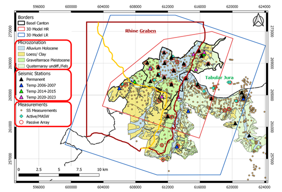
If a spectral microzonation study is published by the responsible authority, this must be used to determine the site-specific earthquake impact in accordance with the Swiss standard SIA 261. Accordingly, the response spectra based on the microzonation study published in 2009 were previously used in the canton of Basel-Stadt and in parts of the cantons of Basel-Landschaft and Solothurn. With the revision of the SIA 261 and SIA 261/1 standards published in 2020, there was reason to review and update the existing microzonation study. In addition, numerous new observation data and reference data have been collected since 2009. The findings can be applied in a microzonation study.


The cantons of Basel-Stadt and Basel-Landschaft have therefore decided to launch a project to revise the microzonation. This microzonation is based on implementation and extension of the amplification models from the work in the Basel earthquake risk model project (2018-2024). The procedure for determining the microzones and their elastic response spectra corresponds to that of the SIA261/1 standard. The microzones are defined with the help of geological and geophysical data. Particular care is taken to ensure that the uncertainties in the models are not too large. For this reason, temporary seismic stations were installed in areas with large uncertainties in the amplification models. Geophysical investigations are also planned. The application of microzonation is simplified by limiting the number of microzones. This is done by combining areas with similar amplification of the earthquake waves. Possible earthquake-induced phenomena will be mapped in analogy to the reference maps of the 2009 microzonation. The project is being carried out in collaboration with the Applied Geology Group (AUG) of the University of Basel, the Chemical and Biosafety Control Authority and the Department of Justice and Security of the Canton of Basel-Stadt, and the Department of Construction and Environmental Protection of the Canton of Basel-Landschaft.

Project Leader al SED

Prof. Donat Fäh

Partecipanti del SED

Afifa Imtiaz, Anastasiia Shynkarenko, Dario Chieppa, Paolo Bergamo

Finanziamento

Kontrollstelle für Chemie- und Biosicherheit und Justiz- und Sicherheitsdepartement des Kantons Basel-Stadt; Bau- und Umweltschutzdirektion des Kantons Basel-Landschaft, Amt für Umwelt des Kantons Solothurn

Durata

2023-2026

Parole chiavi

Site-effects, microzonation, building codes

Settore di ricerca

Earthquake Hazard and Risk, Engineering Seismology

Service Sismologique Suisse
Sonneggstrasse 5
CH-8092 Zurich
Tel. SED segreteria
+41 44 633 21 79 (durante l'orario d'ufficio)

Impressum | Note legali  | ©2024 ETH Zurigo