Premere il tasto Tab per attivare la modalità screen reader.
  • Pagina iniziale
  • Lingua
  • Menu
  • Cerca
  • Lingua facile
  • Contenuto
  • Contatto
MENU
Logo Servizio Sismico Svizzero ETH logo
DE EN FR IT
Lingua facile
DE EN FR IT
×
  • Pagina iniziale
  • Terremoti
    • Svizzera
    • Europa
    • Mondo
    • Mappe
    • Segnalate un terremoto
    • Cosa fare?
      • Raccomandazioni di comportamento
      • Terremoto all’estero
      • Edilizia antisismica
      • Assicurazione antisismica
    • Sempre informati
      • Allerta
      • Ricevere informazioni
      • Stime rapide dei danni
      • ShakeMap
      • Annunci di terremoto
  • Sorveglianza
    • Misurare i terremoti
    • Rete nazionale svizzera
    • Speciali reti
      • Panoramica
      • Geotermia Haute-Sorne
      • Geotermia Yverdon-les-Bains
      • Geotermia bacino di Ginevra
      • Geotermia Vinzel
      • Depositi profondi Svizzera nordorientale
      • Monitoraggio del foro di trivellazione Basilea-1
      • Progetti passati
    • Sismogrammi in tempo reale
      • Ultimi 5 minuti
      • Ultimi 20 minuti
      • Ultime 2 ore
      • Ultime 24 ore
    • Realizzazione di una stazione di registrazione
    • Monitoraggio del Trattato sul divieto degli esperimenti nucleari
  • Svizzera terra di sismi
    • Panoramica
    • Pericolosità
      • Panoramica
      • Componenti
      • Modello di pericolosità sismica
    • Rischio
      • Panoramica
      • Componenti
      • Modello di rischio sismico
      • Strumento di rilevamento del rischio sismico
    • Scenari sismici
    • Regioni sismiche
      • Grigioni
      • Vallese
      • Basilea
    • Terremoti storici
      • I dieci più forti
      • Basilea 1356
      • Sierre 1946
    • Sciami sismici
      • Introduzione
      • Sarnen 1964
      • Diemtigen 2014 - 2015
  • Sapere
    • Cause dei terremoti
      • In genere
      • In Svizzera
      • In Europa
      • Sismi indotti
    • Conseguenze dei terremoti
    • Precursori sismici
    • Portali web e dati sui terremoti
      • Panoramica
      • Software per il monitoraggio dei terremoti
      • Informazioni sulle stazioni
      • Cataloghi dei terremoti
      • Dati sulle forme d’onda
      • FDSN web services
      • Allerta precoce sui terremoti
      • ShakeMap
      • Archivio
    • Geotermia & terremoti
      • Geotermia in breve
      • Forme di energia geotermica
      • Geotermia & terremoti indotti
      • Misure per mitigare sismicità indotta
      • Geotermia in Svizzera
      • Geotermia e il SED
      • Competente consulenza sismologica (GEOBEST2020+)
      • Fracking
    • Scosse su Marte
    • Domande più frequenti (FAQ)
  • Ricerca & insegnamento
    • Progetti
    • Pubblicazioni
    • Insegnamento & formazione
    • Schatzalp Workshop 2025
  • Attualità & publicazioni
    • Articoli attuali
      • 2025
      • 2024
      • Archivio
    • Per le scuole
    • Opuscoli informativi
    • Quiz
    • Video e giochi
    • Simulatore sismico
    • Letteratura sui terremoti
  • Chi siamo
    • Contatti & richieste dei media
    • Profilo
      • Compiti & organizzazione
      • Storia
      • Indipendenza & trasparenza
    • Sezioni
    • Tutti i collaboratori
    • Carriera
    • Cooperazioni
    • Intranet
Il contenuto della pagina inizia qui

Earthquake Risk Model Basel-Stadt

  • Sommario
Immagine del progetto

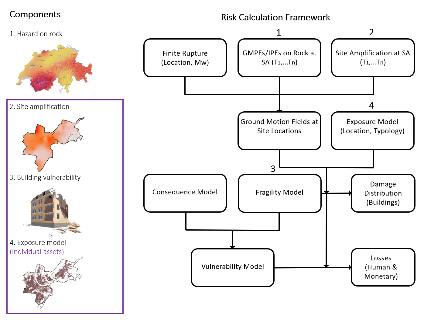
The project Earthquake Risk Model Basel-Stadt (ERM-BS) 2019 to 2023 aims at developing a site specific seismic hazard and risk framework for the Swiss canton of Basel-Stadt. It is a follow-up of the projects Microzonation (2003 - 2009) and Basel Erdbebenvorsorge (2013 - 2016) funded by the canton of Basel-Stadt in its effort to set an earthquake risk mitigation and crisis management strategy for the canton. This project makes a step forward by attempting to develop a 3D integrated geological-seismological model of Basel, which will explicitly account for the complex geological conditions at the surface and at depth. Ground motion amplification models will be developed and validated with earthquake recordings from the permanent and temporary seismic network in the region.


Another aspect of the project involves calculation of risk scenarios by considering building stock, their vulnerability and value, and population of the entire city. A rigorous database of residential, commercial and industrial buildings along with the information related to their structural and non-structural attributes will be compiled. A methodology will be developed to assign different typologies to this large dataset of buildings. Capacity curves and vulnerability parameters will be established for each typology. Finally, detailed risk scenarios based on historical seismicity as well as de-aggregation of the regional seismic hazard will be simulated. One particular focus of the project will be the quantification of uncertainties in the different steps of the process of calculating earthquake risk.


Results obtained from this project are expected to serve the cantonal authorities to adopt proper risk prevention measures (e.g., to identify critical area, to carry out cost-benefit analysis for damage mitigation) as well to plan emergency response strategy (e.g., to rapidly assess damages and identify affected areas) in case of an earthquake occurrence.

Project Leader al SED

Prof. Donat Fäh

Partecipanti del SED

Afifa Imtiaz, Francesco Panzera

Finanziamento

Kanton Basel-Stadt

Durata

2019-2023

Parole chiavi

3D model, Basel city, ground motion amplification, seismic network, site effects, cantonal building database, seismic vulnerability, seismic risk

Settore di ricerca

Engineering Seismology, Seismic Hazard & Risk

Service Sismologique Suisse
Sonneggstrasse 5
CH-8092 Zurich
Tel. SED segreteria
+41 44 633 21 79 (durante l'orario d'ufficio)

Impressum | Note legali  | ©2024 ETH Zurigo