|
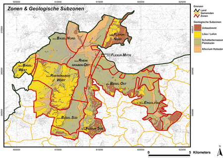
For the city of Basel, a qualitative microzonation was performed in 1997. The zonation was mainly based mainly on the properties of the quaternary sediments. This triggered a study that provided a quantitative assessment of ground motion amplification in order to determine which levels of amplifications have to be taken into account a site-specific hazard assessment in the Basel area. It is the result of two large projects, the ETH project “Earthquake scenarios for Switzerland” (1997-2002) and the INTERREG project “Seismic Microzonation in the upper Rhine Graben area” (2003-2006) (Fäh end Huggenberger, 2006). Earthquakes in the Basel region triggered the strong motion network in Basel and provided a data set for comparison. Spectral ratios from recordings confirm the results of the microzonation study. Finally uniform hazard spectra were derived for each zone by combining the hazard on rock with the amplification functions. The microzonation is published on the Internet: Basel Landschaft: http://geoview.bl.ch Basel Stadt: www.geo.bs.ch/erdbebenmikrozonierung |
|---|---|
| Project Leader al SED | Donat Fäh |
| Partecipanti del SED | Hans Havenith, Ivo Oprsal, Brian Steiner, Sybille Steimen, Philipp Kästli, Gabriela Stamm, Johannes Ripperger, Jan Burjanek |
| Finanziamento | Interreg, Kantone Basel Stadt & Basel Landschaft |
| Durata | 2003-2009 |
| Parole chiavi | Microzonation, Basel |
| Settore di ricerca | Earthquake Hazard & Risk, Engineering Seismology, Microzonation |
Fäh, D. and P. Huggenberger (2006). INTERREG III, Erdbebenmikrozonierung am südlichen Oberrhein. Zusammenfassung für das Projektgebiet Gebiet in der Schweiz. CD and Report (in german; available from the authors).
Fäh, D. and T. Wenk (2009). Mikrozonierung für die Kantone Basel Stadt und Basel Landschaft: Optimierung der Form der Antwortspektren und der Anzahl der Mikrozonen. In: Schweizerischer Erdbebendienst ETH Zürich: Abschlussbericht: Teilbericht B Projekt "Umsetzung der Mikrozonierung in den Kantonen Basel Stadt und Basel Landschaft".
Fäh, D., Steimen, S., Oprsal, I., Ripperger, J., Wössner, J., Schatzmann, R., Kästli, P., Spottke, I. and P. Huggenberger (2006). The earthquake of 250 A.D. in Augusta Raurica, a real event with a 3D site-effect?. Journal of Seismology 10, 459-477.
Fäh, D., Gisler, M., Jaggi, B., Kästli, P., Lutz, T., Masciadri, V., Matt, C. Mayer-Rosa, D., Rippmann, D., Schwarz-Zanetti, G., Tauber, J., Wenk, T. (2009). The 1356 Basel earthquake: an interdisciplinary revision. Geophys. J. Int. 178, 351-374.
Fäh, D. Ripperger, J., Stamm, G., Kästli, P., and J. Burjanek (2009). Mikrozonierung für die Kantone Basel Stadt und Basel Landschaft: Validierung und Umsetzung der Mikrozonierung (2006-2008). In: Schweizerischer Erdbebendienst ETH Zürich: Abschlussbericht: Teilbericht A Projekt "Umsetzung der Mikrozonierung in den Kantonen Basel Stadt und Basel Landschaft".
Havenith, H.-B., Fäh, D., Polom, U. and A. Roulle (2007). S-wave velocity measurements applied to the seismic microzonation of Basel, Upper Rhine Graben. Geophys. J. Int. 170, 346-358.
Kind, F. (2002). Development of microzonation methods: application to Basel, Switzerland. Ph.D. thesis, ETH Zürich, Available in electronic form from www.ethbib.ethz.ch.
Kind, F., Fäh, d., & Giardini, D. (2005). Array measurements of s-wave velocities from ambient vibrations. Geophysical Journal International 160, 114-126.
Meghraoui, M., Delouis, B., Ferry, M., Giardini, D., Huggenberger, P., Spottke, I., & Granet, M. (2001). Active normal faulting in the Upper Rhine Graben and paleoseismic identification of the 1356 Basel Earthquake. Science 293, 2070-2073.
Noack, T. (1993). Geologische Datenbank der Region Basel. Eclogae geol. Helv. 86, 283-301.
Noack, T., Kruspan, P., Fäh, D., & Rüttener, E. (1999). Mikrozonierung von Basel-Stadt. Geologischer Bericht Nr. 24, Landeshydrologie und -Geologie Schweiz.
Oprsal, I., Fäh, D., Mai, M. and D. Giardini (2005). Deterministic earthquake scenario for the Basel area - Simulating strong motion and site effects for Basel, Switzerland. J. Geophys. Res. 110, B04305. doi: 10.1029/2004JB003188
Oprsal, I., Fäh, D. (2007). 1D vs 3D strong ground motion hybrid modelling of site, and pronounced topography effects at Augusta Raurica, Switzerland - Earthquakes or battles? . 4th International Conference on Earthquake Geotechnical Engineering, June 25-28, 2007, Paper No. 1416.
Ripperger, J., Kästli, P., Fäh, D., Giardini, D. (2009). Ground motion and macro-seismic intensities of a seismic event related to geothermal reservoir stimulation below the city of Basel - observations and modelling. Geophysical J. Int. 179, 1757–1771.
Zechner, E., Kind, F., Fäh, D., & Huggenberger, P. (2001). 3-D Geological model of the Southern Rhine Graben compiled on existing geological data and geo-physical reference modeling. Abstract Volume of the 2nd EUCOR-URGENT Workshop, 7.-11. October, Mont Saint-Odile, Strasbourg, France, p. 43.