Earthquake risk (or seismic risk) quantifies the possible effects of earthquakes on buildings and the associated financial and human losses. To determine the earthquake risk more accurately, detailed information about the earthquake hazard, the influence of local subsoil, the vulnerability of buildings, and the people and assets affected are combined in a model.

The national earthquake risk model has made it possible for the first time to quantify the impacts of earthquakes in Switzerland. Over a 100-year period, earthquakes in Switzerland can be expected to cause economic damage of CHF 11 to 44 billion to buildings and their contents (such as furnitures) alone. In total, around 150 to 1,600 people would lose their lives and an estimated 40,000 to 175,000 would become homeless on a short-term or long-term basis. On top of this, there is damage to infrastructure and losses due to other effects of earthquakes such as landslides, fires or business interruptions. However, these are not yet included in the model. The earthquake risk is not evenly distributed over time, but is dominated by rare, catastrophic earthquakes that usually happen without warning.
You can learn more about earthquake risk in Switzerland in the following video:
Greatest risk in urban areas
Urban areas are at greatest risk from earthquakes. The greatest earthquake risk is in the cities of Basel, Geneva, Zurich, Lucerne and Bern, in that order. Although the earthquake hazard in these regions differs, all five cities have, by virtue of their size, a large number of people and assets that would be affected by an earthquake. In addition, these cities have many buildings, some particularly vulnerable and often located on soft ground that amplifies seismic waves.
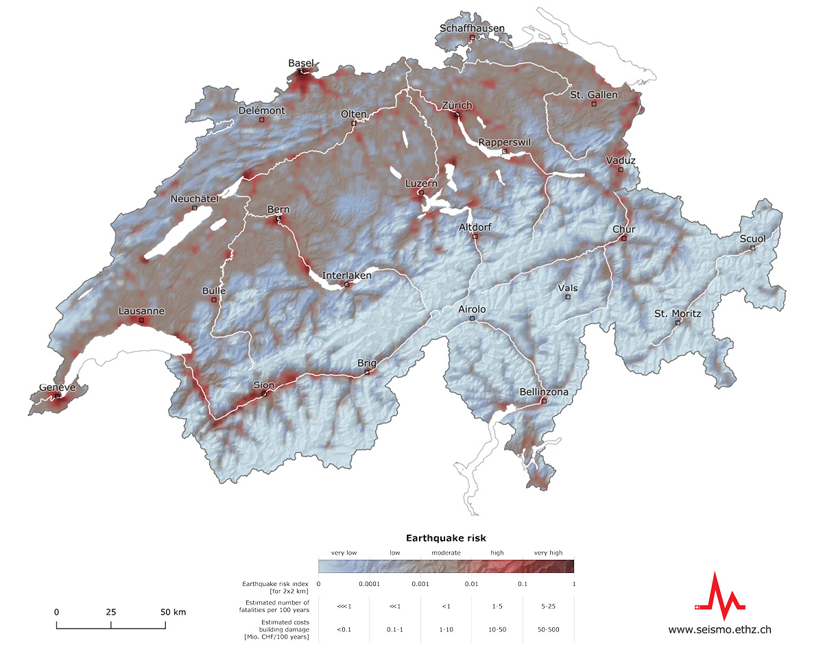
What does the earthquake risk map show?
The earthquake risk map is based on an index that combines the expected number of fatalities with the estimated financial losses due to building damage. The values indicated always refer to an area of 2 x 2 kilometres. The earthquake risk is highest in the areas coloured dark red. The light-blue areas have a lower risk because there are relatively few people and assets in these locations. Even so, the damage to individual buildings in these regions could be devastating. An earthquake risk exists, therefore, throughout Switzerland.
What is the information about earthquake risk used for?
The earthquake risk model is part of the federal government's programme of measures for earthquake mitigation, coordinated by the FOEN, the aim of which is to ensure comprehensive seismic risk management at federal level. The findings from the earthquake risk model will therefore feed into the national risk analysis and to the planning of earthquake mitigation at federal and cantonal levels. They provide a common basis for determining how authorities, the public and businesses can deal with the effects of a damaging earthquake and reinstate destroyed or damaged buildings and infrastructure. In addition, the national earthquake risk model will provide key input for planning and implementing the work of the Schadenorganisation Erdbeben (SOE), which is currently being set up. After an earthquake, the SOE will estimate the expected costs of building damage so that reconstruction can get under way quickly.
The findings of the model will help to improve earthquake mitigation and event response. Switzerland thus becomes one of the first countries in the world to have a freely accessible resource for making informed decisions on earthquake mitigation and event response.
Scenarios
As well as compiling risk assessments for specific periods and locations, the SED can now use the earthquake risk model to develop scenarios. Among other things, this makes it possible to illustrate the effects that damaging historical earthquakes in Switzerland would have if they occurred today. In addition, further scenarios are available for a damaging magnitude-6 earthquake for each cantonal capital and one other locality. Such an earthquake happens on average every 50 to 150 years somewhere in Switzerland or its neighbouring regions.
Check out the 59 scenarios to learn more about the expected effects of earthquakes in Switzerland.
Rapid impact assessments
Based on the earthquake risk model, the SED publishes Rapid Impact Assessments (RIA) after each earthquake with a magnitude of 3 or greater. The RIA will inform the public and emergency services about the expected impacts in the event of damaging earthquakes, or quakes that can be felt over a wide area. Isolated damage is possible near the epicentre with quakes of around magnitude 4 or above.


