Press tab to activate screen reader mode
  • Home
  • Language
  • Navigation menu
  • Search
  • Plain language
  • Content
  • Contact
MENU
Swiss Seismological Service logo ETH logo
DE EN FR IT
Plain language
DE EN FR IT
×
  • Home
  • Earthquakes
    • Switzerland
    • Europe
    • World
    • Maps
    • Report an earthquake
    • What to do?
      • Behavioural recommendations
      • Earthquakes abroad
      • Earthquake-resistant construction
      • Earthquake insurance
    • Always informed
      • Alerting
      • Receive information
      • Rapid impact assessment
      • ShakeMap
      • Earthquake announcements
  • Monitoring
    • Measuring earthquakes
    • National seismic network
    • Special networks
      • Overview
      • Geothermal energy Haute-Sorne
      • Geothermal energy Yverdon-les-Bains
      • Geothermal energy Geneva Basin
      • Geothermal energy Vinzel
      • Geological repository Northeastern Switzerland
      • Monitoring of the Borehole Basel-1
      • Past projects
    • Realtime seismograms
      • Last 5 minutes
      • Last 20 minutes
      • Last 2 hours
      • Last 24 hours
    • Setup of a monitoring station
    • Nuclear test ban treaty monitoring
  • Earthquake country Switzerland
    • Overview
    • Hazard
      • Overview
      • Components
      • Earthquake hazard model
    • Risk
      • Overview
      • Components
      • Earthquake risk model
      • Earthquake risk tool
    • Earthquake scenarios
    • Earthquake regions
      • Grisons
      • Valais
      • Basel
    • Historical earthquakes
      • The ten strongest
      • Basel 1356
      • Sierre 1946
    • Earthquake swarms
      • Introduction
      • Sarnen 1964
      • Diemtigen 2014 - 2015
  • Knowledge
    • Causes of earthquakes
      • In general
      • In Switzerland
      • In Europe
      • Induced earthquakes
    • Effects of earthquakes
    • Earthquake prediction
    • Earthquake data & web portals
      • Overview
      • Earthquake monitoring software
      • Station information
      • Earthquake catalogues
      • Waveform data
      • FDSN web services
      • Earthquake early warning
      • ShakeMap
      • Software archive
    • Geothermal energy & earthquakes
      • Geothermal energy in brief
      • Forms of geothermal energy
      • Geothermal energy & induced earthquakes
      • Measures to control induced seismicity
      • Geothermal energy in Switzerland
      • Geothermal energy and the SED
      • Seismological consulting (GEOBEST2020+)
      • Fracking
    • Quakes on Mars
    • Frequently asked questions (FAQ)
  • Research & teaching
    • Projects
    • Publications
    • Teaching & training
    • Schatzalp Workshop 2025
  • News & services
    • News articles
      • 2025
      • 2024
      • Archive
    • For schools
    • Brochures
    • Quiz
    • Videos & games
    • Earthquake simulator
    • Earthquake literature
  • About us
    • Contact & media enquires
    • Portrait
      • Tasks & organisation
      • History
      • Independence & transparency
    • Sections
    • All employees
    • Careers
    • Cooperations
    • Intranet
The content of the page starts here

Updated soil classification maps for earthquake hazard assessment of the ETH Zurich and PSI areas

  • Overview
Project image

The Federal Building and Real Estate Bodies (BLO) are made up of the three owner representatives armasuisse Real Estate, the Federal Office for Buildings and Logistics (BBL) and the ETH Board. The ETH Board delegates the operational implementation of real estate management to the institutes, namely ETH Zurich, EPFL and the four research institutes PSI, Empa, Eawag and WSL. The BLOs are responsible for ensuring that for constructions earth-quake regulations are implemented. This includes determining the earthquake ground motion level for the planning of new structures or the inspection of existing structures. The seismic impact is determined either in accordance with the SIA 261 standard (2020) using the parameters “seismic zone” and “soil class” or with a site-specific investigation of the seismic hazard (site-specific or microzonation study). Site-specific studies are relatively costly to carry out and are particularly useful for sites with a high concentration of values, high envi-ronmental and personal risk or with potentially high amplification of earthquake excitation. A site study/microzoning can also be useful for necessary retrofitting measures on existing buildings.


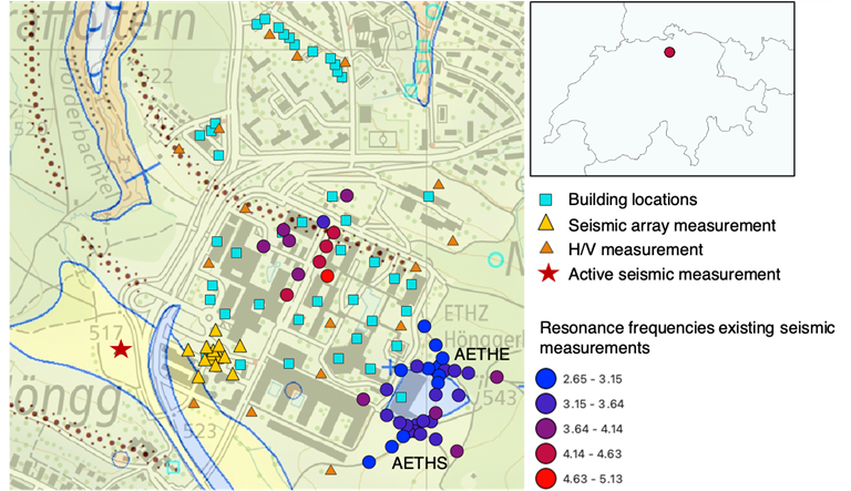
As no current local seismic hazard definition is available for the ETH Zurich and Paul Scherrer Institute (PSI) sites, the real estate managers decided to commission a study for each site from the SED. These studies include the subsoil class maps for the sites and, if possible, microzoning or an estimate of the additional work required for a further phase. For both steps, existing geological information, geotechnical and geophysical measurements are pro-cessed and additional measurements are carried out to close existing gaps. The estimation of the seismic wave amplifications and the elastic response spectra within the areas is carried out using various numerical simulation methods. The results are processed in such a way that the expected changes in the definition of subsoil classes due to the introduction of the second generation Eurocode can be easily implemented.

Project Leader at SED

Paolo Bergamo

SED Project Members

Janneke van Ginkel, Anastasiia Shynkarenko, Paulina Janusz, Donat Fäh

Funding Source

Abteilung Immobilien der ETH Zürich, Abteilung Immobilien & Betrieb des PSI

Duration

2024-2025

Keywords

Building codes, soil classes, microzonation

Research Field

Earthquake Hazard and Risk, Engineering Seismology

Swiss Seismological Service
Sonneggstrasse 5
CH-8092 Zurich
Phone SED secretariat
+41 44 633 21 79 (during office hours)

Imprint | Disclaimer  | ©2024 ETH Zurich