Press tab to activate screen reader mode
  • Home
  • Language
  • Navigation menu
  • Search
  • Plain language
  • Content
  • Contact
MENU
Swiss Seismological Service logo ETH logo
DE EN FR IT
Plain language
DE EN FR IT
×
  • Home
  • Earthquakes
    • Switzerland
    • Europe
    • World
    • Maps
    • Report an earthquake
    • What to do?
      • Behavioural recommendations
      • Earthquakes abroad
      • Earthquake-resistant construction
      • Earthquake insurance
    • Always informed
      • Alerting
      • Receive information
      • Rapid impact assessment
      • ShakeMap
      • Earthquake announcements
  • Monitoring
    • Measuring earthquakes
    • National seismic network
    • Special networks
      • Overview
      • Geothermal energy Haute-Sorne
      • Geothermal energy Yverdon-les-Bains
      • Geothermal energy Geneva Basin
      • Geothermal energy Vinzel
      • Geological repository Northeastern Switzerland
      • Monitoring of the Borehole Basel-1
      • Past projects
    • Realtime seismograms
      • Last 5 minutes
      • Last 20 minutes
      • Last 2 hours
      • Last 24 hours
    • Setup of a monitoring station
    • Nuclear test ban treaty monitoring
  • Earthquake country Switzerland
    • Overview
    • Hazard
      • Overview
      • Components
      • Earthquake hazard model
    • Risk
      • Overview
      • Components
      • Earthquake risk model
      • Earthquake risk tool
    • Earthquake scenarios
    • Earthquake regions
      • Grisons
      • Valais
      • Basel
    • Historical earthquakes
      • The ten strongest
      • Basel 1356
      • Sierre 1946
    • Earthquake swarms
      • Introduction
      • Sarnen 1964
      • Diemtigen 2014 - 2015
  • Knowledge
    • Causes of earthquakes
      • In general
      • In Switzerland
      • In Europe
      • Induced earthquakes
    • Effects of earthquakes
    • Earthquake prediction
    • Earthquake data & web portals
      • Overview
      • Earthquake monitoring software
      • Station information
      • Earthquake catalogues
      • Waveform data
      • FDSN web services
      • Earthquake early warning
      • ShakeMap
      • Software archive
    • Geothermal energy & earthquakes
      • Geothermal energy in brief
      • Forms of geothermal energy
      • Geothermal energy & induced earthquakes
      • Measures to control induced seismicity
      • Geothermal energy in Switzerland
      • Geothermal energy and the SED
      • Seismological consulting (GEOBEST2020+)
      • Fracking
    • Quakes on Mars
    • Frequently asked questions (FAQ)
  • Research & teaching
    • Projects
    • Publications
    • Teaching & training
    • Schatzalp Workshop 2025
  • News & services
    • News articles
      • 2025
      • 2024
      • Archive
    • For schools
    • Brochures
    • Quiz
    • Videos & games
    • Earthquake simulator
    • Earthquake literature
  • About us
    • Contact & media enquires
    • Portrait
      • Tasks & organisation
      • History
      • Independence & transparency
    • Sections
    • All employees
    • Careers
    • Cooperations
    • Intranet
The content of the page starts here

Seismic Hazard Switzerland 2004

  • Overview
  • Hazard report 2004
Project image

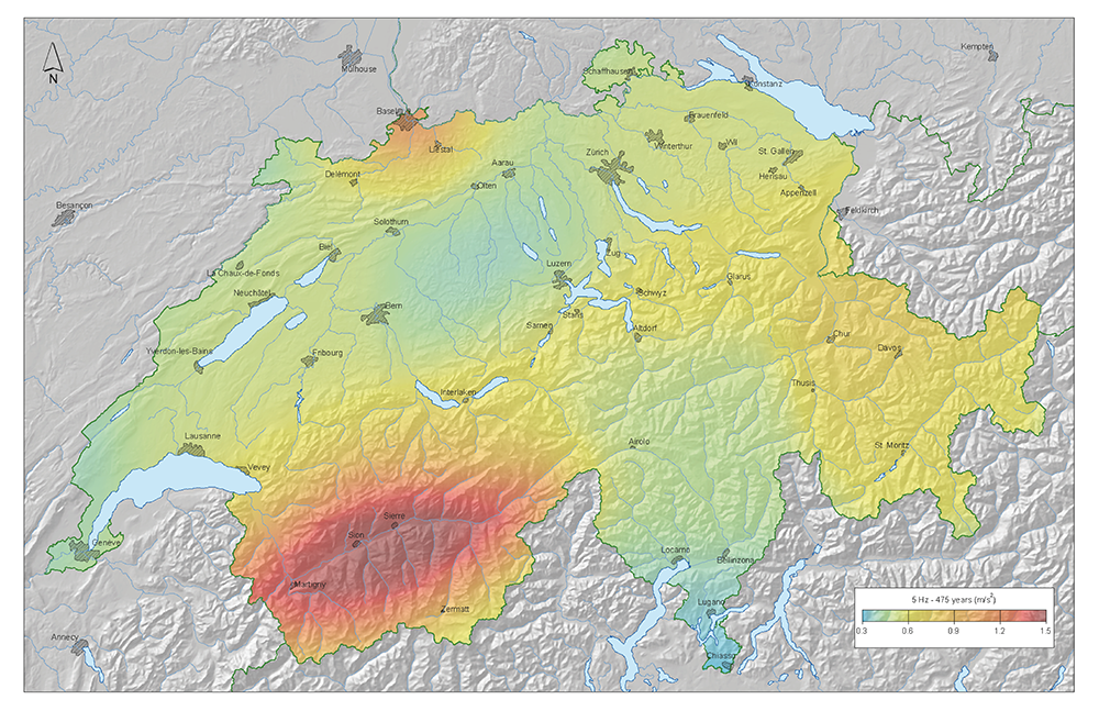
Earthquakes are a serious threat to society and human beings. In order to implement measures to mitigate the consequences of earthquakes, the seismic hazard needs to be well assessed and known. Seismic hazard is defined as the probable level of ground shaking associated with the recurrence of earthquakes in a given time period. The assessment of seismic hazard is the first step in the evaluation of seismic risk. Seismic hazard is assessed by combining the history of past earthquakes with the knowledge of the present seismotectonic setting and the local properties of the waves generated by earthquakes.

We present the results of the 2004 generation of probabilistic seismic hazard assessment for Switzerland. This study replaces the previous intensity based generation of hazard maps from 1976. It is the first to systematically consider alleatory and epistic uncertainties and compute spectral hazard.

Based on a revised moment magnitude earthquake catalog for the period 1300 - 2002, sets of recurrence parameters (a, b-value and Mmax) are estimated for two models of seismotectonic sources zones, using two different completeness reporting models. To estimate alternative a- and b-value sets and their relative weighting, we introduce a novel approach based on the Bayesian information Criterion. From these input parameters, we simulate synthetic earthquake catalogs of 1 Million year duration, reflecting the difference in depth distribution between the alpine Foreland and the Alps. Using a new predictive spectral ground motion attenuation and scaling model (Bay et al., 2004), we estimate expected ground accelerations at 0.5 - 12 Hz for all of Switzerland and return periods of 100, 475, 1000, 2500 and 10'000 years.

The frequency of 5 Hz corresponds to the portion of the spectrum where the local soil conditions are likely to enhance seismic motion. This is also the resonance frequency of 2 to 5 story buildings representing the largest contribution to the building stock of Switzerland. In the map, blue to green colors indicate areas of expected moderate shaking and damage, while red to orange highlight areas expecting more severe shaking and damage in the next 475 years. The zones of higher hazard in Switzerland are the Wallis, the Basel region, Graubünden and the Alpine front. This hazard map is the basic input for the zonation of the Swiss territory and the definition of the design spectra included in the new national seismic building code SIA 261, which is valid since 2004.

Project Leader at SED
Funding Source
Duration

Keywords

Research Field

Download the Report "Seismic Hazard Assessment of Switzerland, 2004" here.

Picture for Hazard report 2004

Swiss Seismological Service
Sonneggstrasse 5
CH-8092 Zurich
Phone SED secretariat
+41 44 633 21 79 (during office hours)

Imprint | Disclaimer  | ©2024 ETH Zurich