|
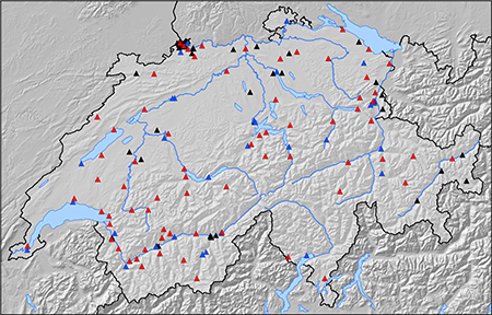
Since 2009, the Swiss Seismological Service is renewing and expanding its strong motion network. During the first phase, a total of 30 new accelerometer stations have been installed between 2009 and 2013, both replacing existing strong motion dial-up stations and installing new stations. During the ongoing second phase, 70 more stations are planned to be installed by 2020, including four borehole installations. The renewal project of the Swiss Strong Motion Network was approved by the Swiss Federal Council in February 2009. The project is monitored and supervised by a steering committee headed by the Swiss Federal Office for the Environment (FOEN).
The goals of the enlargement of the Swiss strong motion network are a better spatial coverage of earthquake-prone regions, a better understanding of site effects and thus the verification and improvement of hazard models.
The epicentral areas of relevant past earthquakes have been instrumented in the first phase, namely Aigle (1584), Glarus (1971), Sarnen (1964), Sion-Sierre (1946), Yverdon (1929), Visp (1855), St. Gallen Rhine Valley (1796/96), Altdorf (1774), Brig (1755), Basel (1356), Churwalden/Vaz (1295/1991), etc. Furthermore, the city areas of Zürich, Geneva, Basel, Bern, Lausanne, St. Gallen, Lucerne, Sion, Solothurn, Locarno, Chur, Sierre are relevant sites for free-field installation.
In the second phase, additional epicentral areas of past earthquakes are targeted: Churwalden (1295), Ardez (1504), Ardon (1524), Arbon (1720), Kreuzlingen (1911), and Moudon (1933), among others. Further urban areas are instrumented as well, e.g. Biel, Fribourg, Neuchâtel, Thun and Winterthur. Another aspect of phase 2 is the densification of the network, especially in earthquake-prone areas such as the Valais.
The site selection is always a trade-off between the scientific objectives and the level of vibration disturbances. Modern stations are sensitive enough to record also small earthquakes, but the signal-to-noise ratio may be too low due to traffic and industries. At all sites, geophysical measurements are performed to characterize the site response. Recorded signals can then be interpreted, and sites classified according to the amplification at the site, which is basic information for improved site-specific seismic hazard studies. |
|---|---|
| Project Leader at SED | Prof. Donat Fäh |
| SED Project Members | Paolo Bergamo, Afifa Imtiaz, Lukas Heiniger, John Clinton, Carlo Cauzzi, Francesco Panzera, Franz Weber, Manuel Hobiger, Eric Zimmermann, Clotaire Michel, u.a. |
| Funding Source | BAFU |
| Duration | 2013-2024 |
| Keywords | SSMNet, strong motion, site characterization |
| Research Field | Swiss Seismicity, Earthquake Hazard & Risk |