Press tab to activate screen reader mode
  • Home
  • Language
  • Navigation menu
  • Search
  • Plain language
  • Content
  • Contact
MENU
Swiss Seismological Service logo ETH logo
DE EN FR IT
Plain language
DE EN FR IT
×
  • Home
  • Earthquakes
    • Switzerland
    • Europe
    • World
    • Maps
    • Report an earthquake
    • What to do?
      • Behavioural recommendations
      • Earthquakes abroad
      • Earthquake-resistant construction
      • Earthquake insurance
    • Always informed
      • Alerting
      • Receive information
      • Rapid impact assessment
      • ShakeMap
      • Earthquake announcements
  • Monitoring
    • Measuring earthquakes
    • National seismic network
    • Special networks
      • Overview
      • Geothermal energy Haute-Sorne
      • Geothermal energy Yverdon-les-Bains
      • Geothermal energy Geneva Basin
      • Geothermal energy Vinzel
      • Geological repository Northeastern Switzerland
      • Monitoring of the Borehole Basel-1
      • Past projects
    • Realtime seismograms
      • Last 5 minutes
      • Last 20 minutes
      • Last 2 hours
      • Last 24 hours
    • Setup of a monitoring station
    • Nuclear test ban treaty monitoring
  • Earthquake country Switzerland
    • Overview
    • Hazard
      • Overview
      • Components
      • Earthquake hazard model
    • Risk
      • Overview
      • Components
      • Earthquake risk model
      • Earthquake risk tool
    • Earthquake scenarios
    • Earthquake regions
      • Grisons
      • Valais
      • Basel
    • Historical earthquakes
      • The ten strongest
      • Basel 1356
      • Sierre 1946
    • Earthquake swarms
      • Introduction
      • Sarnen 1964
      • Diemtigen 2014 - 2015
  • Knowledge
    • Causes of earthquakes
      • In general
      • In Switzerland
      • In Europe
      • Induced earthquakes
    • Effects of earthquakes
    • Earthquake prediction
    • Earthquake data & web portals
      • Overview
      • Earthquake monitoring software
      • Station information
      • Earthquake catalogues
      • Waveform data
      • FDSN web services
      • Earthquake early warning
      • ShakeMap
      • Software archive
    • Geothermal energy & earthquakes
      • Geothermal energy in brief
      • Forms of geothermal energy
      • Geothermal energy & induced earthquakes
      • Measures to control induced seismicity
      • Geothermal energy in Switzerland
      • Geothermal energy and the SED
      • Seismological consulting (GEOBEST2020+)
      • Fracking
    • Quakes on Mars
    • Frequently asked questions (FAQ)
  • Research & teaching
    • Projects
    • Publications
    • Teaching & training
    • Schatzalp Workshop 2025
  • News & services
    • News articles
      • 2025
      • 2024
      • Archive
    • For schools
    • Brochures
    • Quiz
    • Videos & games
    • Earthquake simulator
    • Earthquake literature
  • About us
    • Contact & media enquires
    • Portrait
      • Tasks & organisation
      • History
      • Independence & transparency
    • Sections
    • All employees
    • Careers
    • Cooperations
    • Intranet
The content of the page starts here

Characterization of unstable rock slopes through passive seismic measurements

  • Overview
Project image

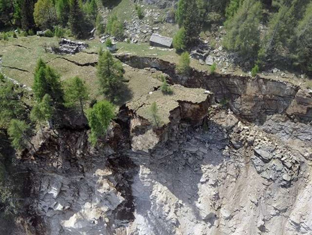
In this ETHZ-funded project we analyze ambient vibration and earthquake recordings to characterize and investigate the dynamic response of unstable rock slopes. We perform systematic measurements and interpretation of ambient vibrations at known unstable rock slopes, both with single stations and array-configurations. The eigenfrequencies, eigenmodes, directivity, and amplification of ambient vibrations are identified and compared to geotechnical investigations. The interpretation of recordings targets the estimation of the potential landslide volume and is supported by numerical modeling of seismic wave propagation in fractured media. A classification scheme based on the seismic response has been introduced. Each class indicates specific properties of a rock instability. The two main classes found are the volume-controlled sites and the depth-controlled sites. The extensive database will be extended with instabilities on high-alpine permafrost locations.

Moreover, both short-term and long-term monitoring is undertaken to understand the time evolution of the slope structure. Short-term monitoring is performed at the Alpe di Roscioro (Preonzo) site which represents a unique opportunity to monitor a slope close to collapse. A second semi-permanent station will be installed on the large rock instability above Brienz (Grisons). A main goal of the monitoring is to understand the effect of weather and climate on the dynamic behavior of the rock and its stability. Long-term monitoring is based on the analysis of available past recordings from existing seismic networks, especially for stations located at or very close to steep cliffs. In a later stage of the project, the effect of earthquakes on the rock slope stability will be evaluated using numerical modelling. It will be evaluated, if ambient noise measurements can provide a direct proxy for the seismic vulnerability of rock slope instabilities. The expected results have the potential to be applied directly in hazard analysis and risk reduction measures.

Project Leader at SED

Prof. Donat Fäh

SED Project Members

Mauro Häusler, Ulrike Kleinbrod

Funding Source

ETHZ

Duration

2013-2021

Keywords

unstable rock slopes, ambient vibrations, ground motion modelling

Research Field

Seismic hazard, earthquake induced effects, engineering seismology

Swiss Seismological Service
Sonneggstrasse 5
CH-8092 Zurich
Phone SED secretariat
+41 44 633 21 79 (during office hours)

Imprint | Disclaimer  | ©2024 ETH Zurich