Press tab to activate screen reader mode
  • Home
  • Language
  • Navigation menu
  • Search
  • Plain language
  • Content
  • Contact
MENU
Swiss Seismological Service logo ETH logo
DE EN FR IT
Plain language
DE EN FR IT
×
  • Home
  • Earthquakes
    • Switzerland
    • Europe
    • World
    • Maps
    • Report an earthquake
    • What to do?
      • Behavioural recommendations
      • Earthquakes abroad
      • Earthquake-resistant construction
      • Earthquake insurance
    • Always informed
      • Alerting
      • Receive information
      • Rapid impact assessment
      • ShakeMap
      • Earthquake announcements
  • Monitoring
    • Measuring earthquakes
    • National seismic network
    • Special networks
      • Overview
      • Geothermal energy Haute-Sorne
      • Geothermal energy Yverdon-les-Bains
      • Geothermal energy Geneva Basin
      • Geothermal energy Vinzel
      • Geological repository Northeastern Switzerland
      • Monitoring of the Borehole Basel-1
      • Past projects
    • Realtime seismograms
      • Last 5 minutes
      • Last 20 minutes
      • Last 2 hours
      • Last 24 hours
    • Setup of a monitoring station
    • Nuclear test ban treaty monitoring
  • Earthquake country Switzerland
    • Overview
    • Hazard
      • Overview
      • Components
      • Earthquake hazard model
    • Risk
      • Overview
      • Components
      • Earthquake risk model
      • Earthquake risk tool
    • Earthquake scenarios
    • Earthquake regions
      • Grisons
      • Valais
      • Basel
    • Historical earthquakes
      • The ten strongest
      • Basel 1356
      • Sierre 1946
    • Earthquake swarms
      • Introduction
      • Sarnen 1964
      • Diemtigen 2014 - 2015
  • Knowledge
    • Causes of earthquakes
      • In general
      • In Switzerland
      • In Europe
      • Induced earthquakes
    • Effects of earthquakes
    • Earthquake prediction
    • Earthquake data & web portals
      • Overview
      • Earthquake monitoring software
      • Station information
      • Earthquake catalogues
      • Waveform data
      • FDSN web services
      • Earthquake early warning
      • ShakeMap
      • Software archive
    • Geothermal energy & earthquakes
      • Geothermal energy in brief
      • Forms of geothermal energy
      • Geothermal energy & induced earthquakes
      • Measures to control induced seismicity
      • Geothermal energy in Switzerland
      • Geothermal energy and the SED
      • Seismological consulting (GEOBEST2020+)
      • Fracking
    • Quakes on Mars
    • Frequently asked questions (FAQ)
  • Research & teaching
    • Projects
    • Publications
    • Teaching & training
    • Schatzalp Workshop 2025
  • News & services
    • News articles
      • 2025
      • 2024
      • Archive
    • For schools
    • Brochures
    • Quiz
    • Videos & games
    • Earthquake simulator
    • Earthquake literature
  • About us
    • Contact & media enquires
    • Portrait
      • Tasks & organisation
      • History
      • Independence & transparency
    • Sections
    • All employees
    • Careers
    • Cooperations
    • Intranet
The content of the page starts here

Seismic monitoring of the rock instability at the former Mitholz ammunition depot

  • Overview
  • Publications
Project image

There is a higher risk of explosion from ammunition ordnance in the former Mitholz ammunition depot than previously assumed. For this reason, it was decided to completely clear the site. The results published in the work by Glueer et al. (2021) show that a possible earthquake-induced rockfall should be taken into account in risk assessments. Large amplifications of seismic waves are observed on the rock mass above the cavern at Mitholz, the origin of which is the strong internal disruption of the rock mass due to the explosions in 1947. The Federal Department of Defence, Civil Protection and Sport (DDPS) and ETH Zurich are therefore conducting a joint seismological research and measurement project. This includes an alarming after an earthquake, the installation of permanent and temporary seismic sensors and the development of a 3D model of the underground.


Alarming after an earthquake is triggered if defined threshold values are exceeded. This is integrated into the standard operation system within SED. Seismic stations are being installed on the rock formation above the caverns in the Mitholz area. These allow the measurement of earthquake amplification and its temporal variability, in particular the investigation of the dependence on water in the fissures and the recording of changes in the behaviour of the local structure during the extraction of rock material at the rock face. During the seismic measurements, the dynamic behaviour of the local structure at the site on the rock face is continuously derived from the ambient vibrations, enabling the detection of possible changes in the behaviour of the rock mass.


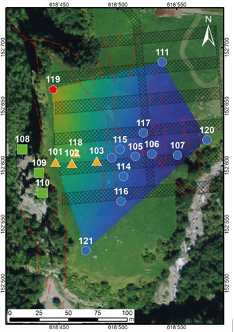
To optimise the positioning of the permanent seismic stations, ambient vibration measurements are carried out over the entire rock formation above the caverns using dense arrays of seismic sensors. The aim of the measurements is to map the natural frequencies and polarisation of the wave field as a whole. We use the scientific methods developed at the SED, and thus to obtain information about the internal structure of the rock mass, particularly regarding the potential disruption of the material at the rock front and deep fracture structures that delimit the large volumes. These investigations are combined with engineering-geological studies. They lead to the development of a three-dimensional model, which is used for modelling earthquake effects.

Project Leader at SED

Prof. Donat Fäh

SED Project Members

Franziska Glüer, Mauro Häusler, Xavier Borgeat, Valentin Gischig

Funding Source

Eidgenössische Departement für Verteidigung, Bevölkerungsschutz und Sport (VBS)

Duration

2024-2025

Keywords

Earthquake induced mass movements, unstable rock-slopes, real-time monitoring, seismic methods

Research Field

Earthquake Hazard and Risk, Geo Risks

Glueer, F., Häusler, M., Gischig, V. and Fäh, D.  (2021). Coseismic Stability Assessment of a Damaged Underground Ammunition Storage Chamber Through Ambient Vibration Recordings and Numerical Modelling. Front. Earth Sci.  https://doi.org/10.3389/feart.2021.773155 

Häusler, M., Glueer, F., & Fäh, D. (2024). The changing seismic site response of the Brienz/Brinzauls rock slope instability: insights from 5 years of monitoring before, during and after a partial collapse in June 2023. ICL open access book series “Progress in Landslide Research and Technology” 2-12. 

Burjanek, J., Kleinbrod, U., & Fäh, D. (2019). Modeling the Seismic Response of Unstable Rock Mass With Deep Compliant Fractures. Journal of Geophysical Research-Solid Earth 124(12), 13039-13059. doi: 10.1029/2019jb018607

Häusler, M., Michel, C., Burjanek, J., & Fäh, D. (2019). Fracture Network Imaging on Rock Slope Instabilities Using Resonance Mode Analysis. Geophysical Research Letters 46(12), 6497-6506. doi: 10.1029/2019gl083201

Häusler, M., Gischig, V., Thöny, R., Glueer, F. and Fäh, D. (2021). Monitoring the changing seismic site response of a fast-moving rockslide (Brienz/Brinzauls, Switzerland). Geophysical Journal International 229 (1), 299-310. doi: 10.1093/gji/ggab473

Kleinbrod, U., Burjanek, J., & Fäh, D. (2019). Ambient vibration classification of unstable rock slopes: A systematic approach. Engineering Geology 249, 198-217. doi: 10.1016/j.enggeo.2018.12.012

Swiss Seismological Service
Sonneggstrasse 5
CH-8092 Zurich
Phone SED secretariat
+41 44 633 21 79 (during office hours)

Imprint | Disclaimer  | ©2024 ETH Zurich