2017-03-06
Summary of the magnitude 4.6 Urnerboden Earthquake
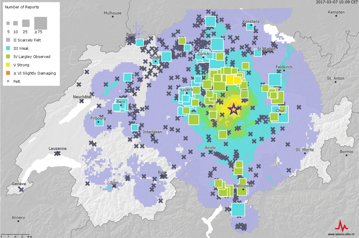
The epicenter of the Magnitude 4.6 (local or Richter magnitude ML) earthquake of 2017/03/06 21:12 local time is located about 3 km NE of the village of Urnerboden in the border region of cantons Uri, Schwyz, and Glarus. The preliminary focal depth is determined to be about 5 km. The Ml 4.6 earthquake was preceded by several foreshocks with ML ranging between 0.2 to 2.2. In the first 12 hours after the ML 4.6 event, the SED recorded about 25 aftershocks with magnitudes between ML 0.5 and 2.9. Further aftershocks, some of them perceptible, are expected over the coming days. Earthquakes with a similar or even larger magnitude than the current main shock are unlikely, but cannot be excluded.
Read more...The shaking from this event was felt by the majority of people across Central Switzerland. The Swiss Seismological Service also received more than 5000 earthquake reports from a region of about 200 km diameter, including Ticino and the cantons of Bern, Aargau, Basel, Zurich and Grisons up to Chur. The high public interest was evident also in the up to 500’000 requests per minute on the SED websites. This high demand led to the SED's web pages partially not being accessible in the first 40 minutes after the event, and after that for some time with delays.
The epicenter is located in the Helvetic nappes. The preliminary focal depth of 5 km indicates a source at the border of the sedimentary cover and the crystalline basement. The moment tensor solution for this earthquake indicates it had a moment magnitude of MW 4.1 with a strike-slip mechanism, with either a NNW-SSE or WSW-ENE striking fault plane, consistent with other events in this region. These mechanisms indicate northwest-southeast oriented compression of the crust in this region of the Helvetic domain. Last night’s earthquake occurred close to the magnitude 4.0 (ML) Urnerboden earthquake of 5 May 2003. The depth and the focal mechanism of that event are very similar to yesterday’s earthquake and it seems likely that both events are associated with the same fault system.
Generally speaking, tectonic stresses in the Alps are the result of the collision between the European and the African lithospheric plates. However, due to the complex tectonic structure and history of the Alpine collision zone, significant along-strike variations in the tectonic regimes are observed.
The highest acceleration measured by seismic instruments were reported from Linthal (GL) and reached 85 cm/s2. On average, earthquakes of this size happen approximately once every 5 years in Switzerland. The last earthquake with a similarly large magnitude was the Vallorcine (F) (4.9 ML) event close to the Swiss border near Martigny (VS) on 8 September, 2005. It was strongly felt in the Valais.
On Wednesday 7 March, the SED installed two additional stations at Urnerboden and Bisisthal. These stations will allow characterizing the aftershock sequence and thus the properties of the activated fault in more detail.