2017-09-25
Measuring Strong Earthquakes with GPS
GPS is well known to navigate to a specific location. Less known is another feature: GPS signals can also be used to measure strong earthquakes. This reveals a recently published study in the “Bulletin of the Seismological Society of America” in cooperation with researchers from the Swiss Seismological Service (SED) at ETH Zurich. Complementary to conventional seismic measurements, GPS data can support the near real time monitoring of earthquakes. Integrating GPS data would allow a more accurate calculation of ShakeMaps that are vital for emergency management.
Read more...Generally, accelerometers, measuring the acceleration of the ground motion, are used to register strong earthquakes. The ground motion they can record is limited in the low frequency range (slow motion) while GPS instruments are conversely limited in the high frequency range (rapid motion). Permanent GPS (GNSS) stations are covering the globe to serve as reference points for surveying and positioning. GPS instruments are therefore complementary in the way they record ground vibrations and their network is complementary in terms of spatial coverage.
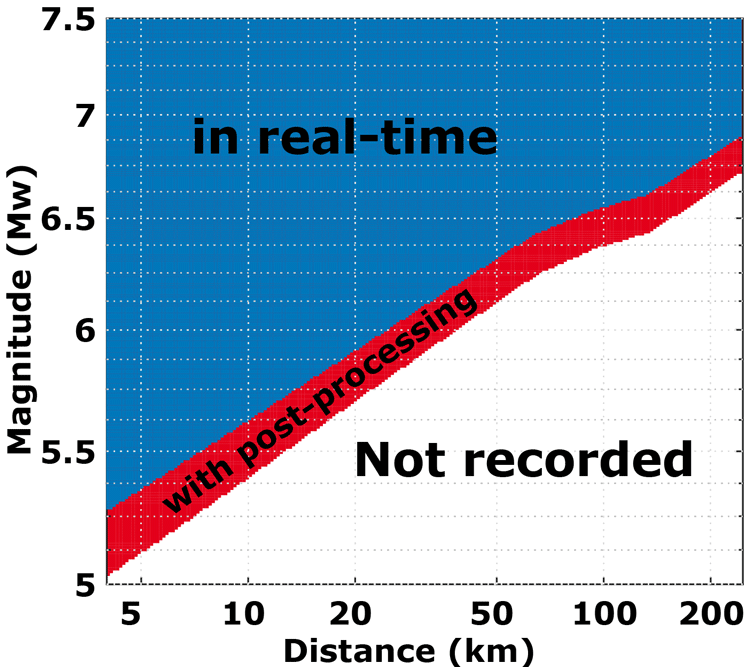
To make use of these advantages, the aforementioned study is investigating what future improvements of GPS data processing will bring (see red area in the graphic). Recording strong earthquakes could be further optimized by increasing the sampling rate of GPS stations by a factor of two to five. GPS data is an added value to conventional accelerometric data for events of a magnitude 5.8 or greater within a radius of 10 km. Their integration into emergency tools such as ShakeMaps might therefore be of great value in countries with a high seismic hazard, like Japan.
Figure: Capability of GPS permanent stations to record strong earthquakes in real-time (blue) as a function of magnitude and distance from the fault rupture. What is currently doable after post processing (red) will be achieved in the future in real-time.
Clotaire Michel, Krisztina Kelevitz, Nicolas Houlié, Benjamin Edwards, Panagiotis Psimoulis, Zhenzhong Su, John Clinton, Domenico Giardini; The Potential of High‐Rate GPS for Strong Ground Motion Assessment. Bulletin of the Seismological Society of America; 107 (4): 1849–1859. doi: https://doi.org/10.1785/0120160296