2021-01-25
75 years since Switzerland's last major earthquake
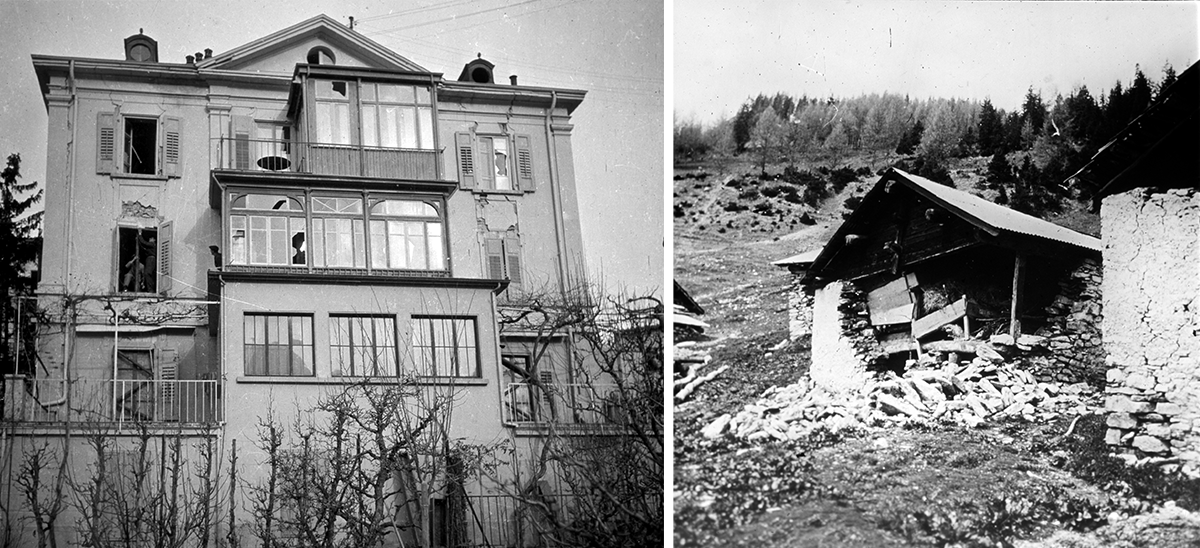
It was already dark on 25 January 1946 when a violent earthquake with a magnitude of 5.8 shook Valais. Four people were killed, many were injured and 3,500 buildings were damaged, some of them severely. It took some time for the full extent of the quake to become clear. This was not only to do with the time at which the earthquake struck, but also with the scale of the damage and the options available at the time for evaluating seismic data. As well as causing damage to buildings, much of which only became apparent in daylight, the earthquake triggered avalanches and rockslides. In addition, the data from the few seismographs in Switzerland had to be read and analysed manually. Collecting 'felt reports' and damage reports was just as laborious, and such reports were more important back then due to the small number of instrumental records. This was the biggest Swiss earthquake in the past 150 years and the last one to claim lives. Could such an earthquake happen again and what would its impact be today?
Read more...A comparable earthquake can be expected to hit Switzerland every 50 to 150 years, but earthquakes do not follow a precise timetable. The next big quake could equally happen very soon or in a few decades' time. Along with the Basel region, Grisons, Central Switzerland and the St. Gallen Rhine Valley, Valais is one of the areas with the highest seismic-hazard levels in the country. Although major earthquakes can theoretically occur throughout Switzerland, the number of earthquakes in these regions is greater, meaning that powerful earthquakes are also more frequent there. If an earthquake similar to that of 75 years ago were to strike the Rhone Valley today, the impact would be much greater, probably causing around CHF 26 million of damage, as the area is more densely populated.
Perceptible tremors regularly remind the people of Valais that the ground beneath their feet is seismically active. In addition to individual quakes, earthquake sequences often occur in Valais, as elsewhere in Switzerland. A particularly active sequence, with over 16 felt quakes in 10 days, was observed near the Sanetsch Pass in 2019. The 56 seismic stations in Valais also record many smaller earthquakes. This dense monitoring makes it possible to track seismic activity around the clock and to inform the population, authorities and the media immediately in the event of major tremors or quakes. The analysis of seismic data also helps us to better understand the local subsurface and is therefore instrumental in ensuring earthquake preparedness. In addition to knowledge about recommended behaviour, earthquake-resistant construction is particularly crucial for mitigating the impacts of an earthquake. The canton of Valais has invested heavily in both these areas in recent years.
Earthquake activity in Valais, and throughout Switzerland, is linked to collisions between the European and African lithospheric plates. These generate numerous fault systems in the subsurface, where tension builds up and is then suddenly released in the form of earthquakes. From a geological point of view, the Rhone-Simplon line, running in the Sion area along the northern edge of the Rhone Valley, is one of the main fault zones in the region. The seismicity around the Helvetic nappes north of the Rhone Valley is therefore probably related to the deformation processes along the Rhone-Simplon fault line, but possibly also to the deeper uplift processes in the area of the Aar massif and the Aiguilles Rouges/Mont Blanc massif. Research being conducted by the Swiss Seismological Service (SED) at ETH Zurich aims to improve our understanding of these tectonic processes and their effects on current seismicity. The SED is also developing an earthquake risk model for Switzerland together with the Federal Office for the Environment, the Federal Office for Civil Protection and EPFL. In the future, this will help to better assess the possible impacts of an earthquake and verify the cost-effectiveness of prevention measures.