Engineering seismology
Engineering seismology is a key component for calculating seismic hazard and risk. This involves creating reliable ground motion models, developing high-definition geological subsurface models, and interpreting historical accounts.
Seismic hazard mapping and risk assessment

Engineering seismologists produce local seismic hazard maps (microzonation) investigating the impact of local geological conditions on the earthquake ground motions. This enables the development of practical guidelines for civil engineering (e.g. construction standards) and spatial planning. Furthermore, estimating the soil response is one of the fundamental steps for translating seismic hazard into risk (e.g. expected damages, losses).
Understanding ground conditions and seismic impact
A major challenge is understanding how local soil conditions influence seismic activity. Soft sediments, such as those in valley bottoms or near lakes, can amplify seismic waves up to ten times more than bedrock. Microzonation studies involve:
- Mapping geological and geotechnical features that may affect earthquake ground motion
- Assessing the potential for soil liquefaction
- Conducting geophysical measurements to determine the properties of the subsurface
- Running simulations based on earthquake data to estimate the impact of local geological conditions.
Developing ground motion models for risk mitigation
Ground motion models play a crucial role in risk mitigation strategies, updating building codes, and ensuring dam safety standards. In collaboration with the Swiss Federal Nuclear Safety Inspectorate (ENSI), the SED is updating Switzerland’s stochastic ground motion model. Additionally, the SED is developing tools to estimate ground motion at depth from surface earthquake data, which is particularly relevant for projects like the nuclear waste repository.
High-resolution national site amplification model
Over two decades, the SED has compiled a vast geophysical data archive. This has led to the development of a high-resolution national site amplification model under the earthquake risk model of Switzerland (ERM-CH23). Based on geospatial prediction techniques and local seismic data, this model is continually refined with higher-resolution geological information and additional instrumented site data.
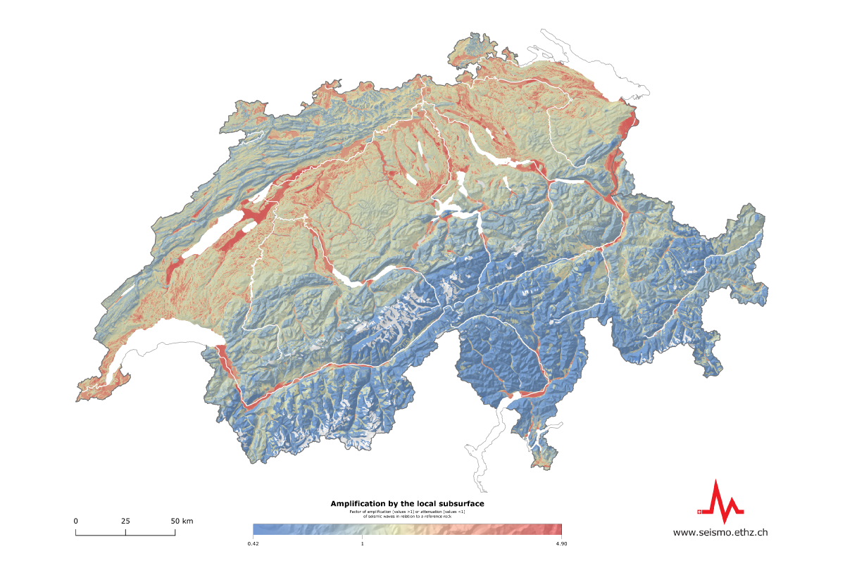
Map of amplification by the local subsurface: The local subsoil affects how strong the shaking from an earthquake will be at a particular location: the softer the subsoil, the more the seismic waves are amplified. This map shows the soil amplification of the seismic waves compared to a standard reference rock (with an average S-wave velocity in the shallower 30m, Vs30, of 1100 m/s): Values greater than 1 mean a higher amplification, values below mean a lower amplification.
Contributions to seismic building codes and standards
The engineering seismology at SED carries out studies contributing to:
- The revision and update of seismic building codes
- The definition of seismic standards for dams
- The assessment of site response in peculiar morphological settings, e.g. alpine valleys, lake bottoms
The engineering seismology group is led by Dr. Paolo Bergamo.

Field campaigns of engineering seismology group. From left to right, top to bottom: single-station ambient vibration measurements for the microzonation in the Cantons Basel-Stadt and -Landschaft, wherelight-weight portable 5s nodes were transported using e-bikes; ocean bottom seismometers deployed in Lake Lucerne from a platform; active (left) and passive (right) surface-wave measurements for site characterization.