M.Erdik, Y.Alpay Biro, T.Onur, K.Sesetyan and G.Birgoren
Bogazici University
Kandilli Observatory and Earthquake Research Institute
81220 Cengelkoy, Istanbul
ABSTRACT
The aim of this study is to conduct a probabilistic seismic hazard analysis for Turkey and neighboring regions, using the most recently developed attenuation relationships. The seismicity database is compiled from numerous sources, and the tectonic setting of the region has been studied in detail. Utilizing these two major categories of information together with the selected attenuation relationships, the seismic source zones are determined, and PGA contour maps are produced for specific return periods. The study is intended to serve as a reference for more advanced approaches and to stimulate discussion and suggestions on the data base, assumptions and the inputs, and to pave the path for the probabilistic assessment of the seismic hazard in the site selection and the design of engineering structures.
INTRODUCTION
Seismic hazard analyses aim at assessing the probability that the ground motion parameter at a site due to the earthquakes from potential seismic sources will exceed a certain value in a given time period.
Apart from the numerous studies of local or regional scale, the studies of Alsan (1972), Gencoglu and Tabban (1973), Ucer et al. (1977), Bath (1979) and Hattori (1979) have addressed the problem of assessment of the seismic hazard in Turkey through the statistical manipulation of the past instrumental earthquake data with no consideration of the seismic source regionalization. Within the context of the UNESCO project titled "Survey of the Seismicity of the Balkan Region", a rather elaborate probabilistic seismic hazard assessment was carried out for Western Turkey (Algermissen et al., 1974). More comprehensive studies on the subject matter have been conducted by Yarar et al. (1980), Erdik and Oner (1982) , Erdik et al. (1982), Erdik et al. (1985) and Gulkan et al. (1993). The maps provided in Erdik et al. (1985) contain probabilistic estimates of the maximum MSK intensity, and maximum horizontal peak ground acceleration for return periods of 225, 475 and 10,000 years. The study reported herein is conducted in connection with the Global Seismic Hazard Assessment Program (GSHAP, see Giardini and Basham, 1993).
Turkey lies within the Mediterranean sector of the Alpine-Himalayan orogenic system, which extends from Italy to Burma. This system, identified with high mountain ranges and shallow, somewhat diffuse seismicity, constitute one of the most seismically active continental regions of the world with a long and well documented history of earthquakes.
Portrayal of the seismicity and the tectonics of a region provide the essential information towards the assessment of seismic source zones. Almost all earthquakes in Turkey and its vicinity is associated with tectonic elements. The correlation of seismicity with the tectonic elements (seismo-tectonics) constitutes an important phase of the earthquake hazard assessment and, as such, several micro-plate tectonics models have been proposed.
The bulk of Anatolia, Aegean Sea and Cyprus is located on the Anatolian (or Turkish) Plate. The northern boundary of the Anatolian Plate is the Anatolian Trough and the right-lateral, strike-slip North Anatolian Fault (NAF). The southern boundary of the Anatolian Plate is formed by the Hellenic Arc, south of Cyprus and the East Anatolian Fault (EAF), which joins the NAF at Karliova. The EAF, located between the Gulf of Iskenderun and Karliova, is a left lateral, strike-slip fault. The south-westward motion of the Anatolian Plate, relative to Africa, is taken up by the subduction along the Hellenic Trench. In Western Anatolia, the east-west trending grabens account for most of the seismic events of this region. The area encompassing Turkey, from the Aegean region in the west to the Caucasus in the east is comprised of many major seismically active regions. The Aegean region, the Caucasus, the North Anatolian Fault Zone and the East Anatolian Fault Zone are the most well known among these, where countless damaging earthquakes have occurred throughout history.
The seismicity compilations are based on the specially-compiled catalogs of historical and instrumental data. Attention is paid to the cross-correlation of instrumental and historical earthquake data. Uniformity in magnitude is implemented by converting all magnitudes to moment magnitude. The data is biased with respect to the reporting periods and magnitude ranges, and can only be considered to be homogenous for magnitude 4 and above for the last several decades.
Seismic sources are identified by using the macro-seismic locations of historic earthquakes and instrumental locations of the last 50 years' earthquakes. Delineation of the source boundaries is based on neo-tectonic elements and sudden variations in the homogeneity of the seismicity. All together 37 earthquake source zones were identified. In addition several background seismic zones are defined to account for floating earthquakes not accounted by these sources and also to delineate zones where no significant earthquake has taken place for centuries.
For the assessment of the recurrence relationships in these source zones the rates of occurrence in different magnitude groups are adjusted by determination of the period over which the data in a given magnitude group are completely reported.
For depicting earthquake ground motion severity, predictive empirical relationships for MSK intensity (attenuation relationships developed for Eastern Turkey and tested for Northern Iran), peak ground accelerations and spectral amplitudes at the periods of 0.2s and 1s and for different site classes are considered. However in this paper only the results for peak ground acceleration on competent soil corresponding to 10% probability of exccedance in 50 years is presented.
For the probabilistic hazard analysis SEISRISK III (Bender and Perkins,
1987) routine, in-house improved with graphical pre- and post-processors,
is used. The stochastic model used in this routine assumes that the generation
of earthquakes in the time domain follows a homogenous Poisson process.
The pro's and con's of this assumption is discussed. The routine allows
for variability of the source boundaries. A sensitivity analysis conducted
indicated that this effect is not important considering the return periods
and the geometry of the sources.
METHODOLOGY
The evolution of seismic hazard assessment can be traced in five generations of methodology (Muir-Wood, 1993). These are: Historical determinism; Historical probabilism; Seismotectonic probablisim; Non-Poissonian probablism; and Earthquake prediction. The seismotectonic probabilizm method of hazard assessment used in this study does not rely solely on historical seismicity records but combines it with geological knowledge, that is the data of paleoseismic ground motions and data of neotectonic faulting, and with the scientific seismotectonic understanding of earthquake causes. These data are combined through a seismic source model, but the uncertainty in the determination of the input parameters are incorporated in the form of a weighted range of values.
The general methodology in calculating seismic hazard is well established in literature (e.g. Cornell 1968). The method involves two separate models: a seismicity model describing a geographical distribution event sources and the distribution of magnitudes, and an attenuation model describing the effect at any site given as a function of magnitude and source-to-site-distance. The seismicity model may comprise a number of source regions, the seismicity of which should be expressed in terms of a recurrence relationship of events with magnitudes greater or equal to a certain value. The attenuation model relates the earthquake intensity (i.e. the effect of it, as a general term) at a site to magnitude, distance, source parameters and site conditions.
For forecasting seismic occurrences numerous models have been developed. The simplest stochastic model for earthquake occurrences is the Homogeneous Poisson Model, which is used in this study. For the earthquake events to follow that model, the following assumptions are in order: Earthquakes are spatially independent; Earthquakes are temporally independent; and Probability that two seismic events will take place at the same time and at the same place approaches zero.
Although not specifically required in the SEISRISK III program utilized, the recurrence relationship of the events is expressed with the help of the empirical relationship first defined by Gutenberg - Richter: log N = a + bM. Where N is the number of shocks with magnitude greater or equal to M per unit time and unit area, and a and b are regression paremeters the seismic source region considered. Using an application of the total probability theorem the probability per unit time that that ground motion amplitude a* is exceeded can be expressed as follows (McGuire, 1993):
![]() (1)
(1)
where ![]() is the probability
that the maximum effect I is less than i. given m and r,
is the probability
that the maximum effect I is less than i. given m and r, ![]() is the probability density function for magnitude,
is the probability density function for magnitude, ![]() and is the probability distribution function for distance.
and is the probability distribution function for distance. ![]() is dependent on the geometric nature of the source.
is dependent on the geometric nature of the source.
TECTONIC SETTING
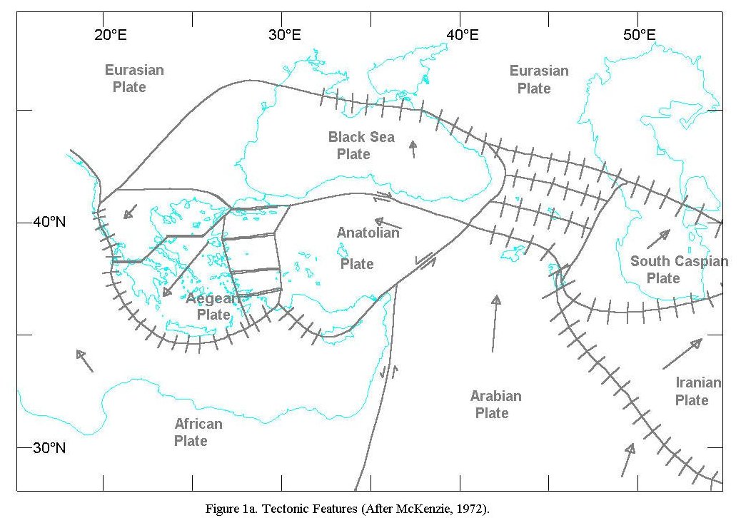
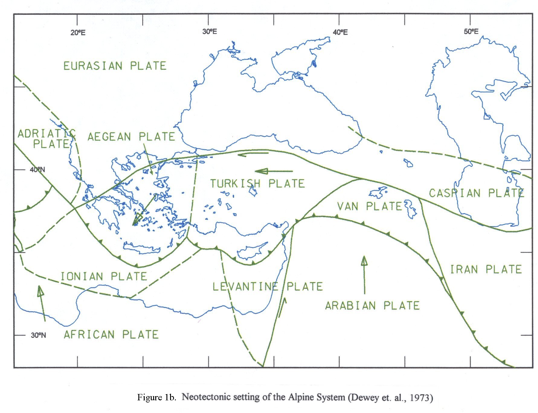
Turkey lies within the Mediterranean sector of the Alpine-Himalayan orogenic system, which runs west east from the Mediterranean to Asia. The Alpine orogeny is produced as a result of the compressional motion between Europe and Africa, whereas the Himalayan orogeny has resulted from the India-Asia collision. Turkey is surrounded by three major plates: African, Eurasian, and Arabian, and two generally acknowledged minor plates: Aegean and Anatolian, as shown in the neo-tectonic models of McKenzie (1972) and Dewey et. al (1973) presented in Figures 1a and Figures 1b.
In his widely accepted model, McKenzie (1972) divided the region into three additional small plates (Iranian, South Caspian, and Black Sea) apart from the three major and two minor plates. His sketch of plate boundaries and motions is given in Figure1a. The arrows indicate the directions of motion relative to Eurasia and their lengths are approximately proportional to the magnitude of relative velocity. Plate boundaries across which extension is taking place are shown by a double line, transform faults by a single heavy line and boundaries across which shortening is occurring by a solid line crossed by short lines at right angles. The African plate is moving northwards towards Eurasian Plate, pushing the Turkish plate in a westward motion. The North Anatolian Fault and the East Anatolian Fault constitute the northern and southern boundaries, respectively, of this plate, while the southern boundary is not well defined by seismicity.
East of 20ºE the motion between Africa and Eurasia is not taken up on one plate boundary, but is carried by the motion of the Aegean and Turkish plates. The boundary between the Aegean and Turkish plates forms a north-south trending belt of seismicity across western Turkey and the eastern Aegean. The Aegean plate is moving towards the southwest relative to the European plate, producing extension and strike-slip motion along the boundary between the two plates. The southern boundary of the Aegean plate is moving southwest relative to the African plate, and is overthrusting the Mediterranean Sea floor. At the eastern end of the Turkish plate, the motion is taken up by thrust faults associated with the Caucasus. The result of this geometry is a thickening of the continent throughout the active region, which continues to elevate the Caucasus. Thrusting in eastern Turkey and the Caucasus changes to strike-slip motion between the Turkish and Eurasian plates at the eastern outset of the North Anatolian Fault Zone. McKenzie (1972) conjectures that the relative motion between the Black Sea and the Eurasian plate must be in a north-south direction with the Black Sea moving towards Eurasia, though rather slowly, since the seismicity of this boundary has been low for most of this century.
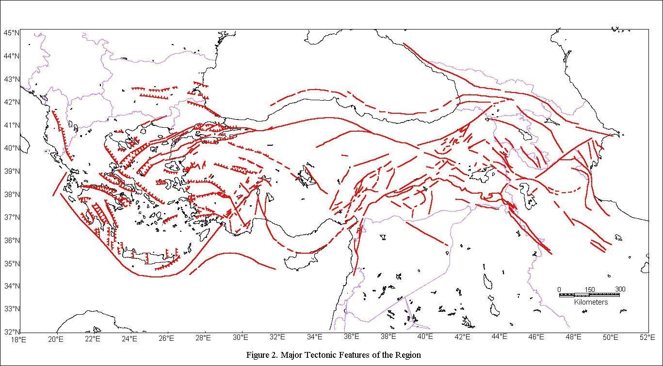
The major tectonic elements of Turkey adopted after Barka (1992) are
shown in Figure 2.
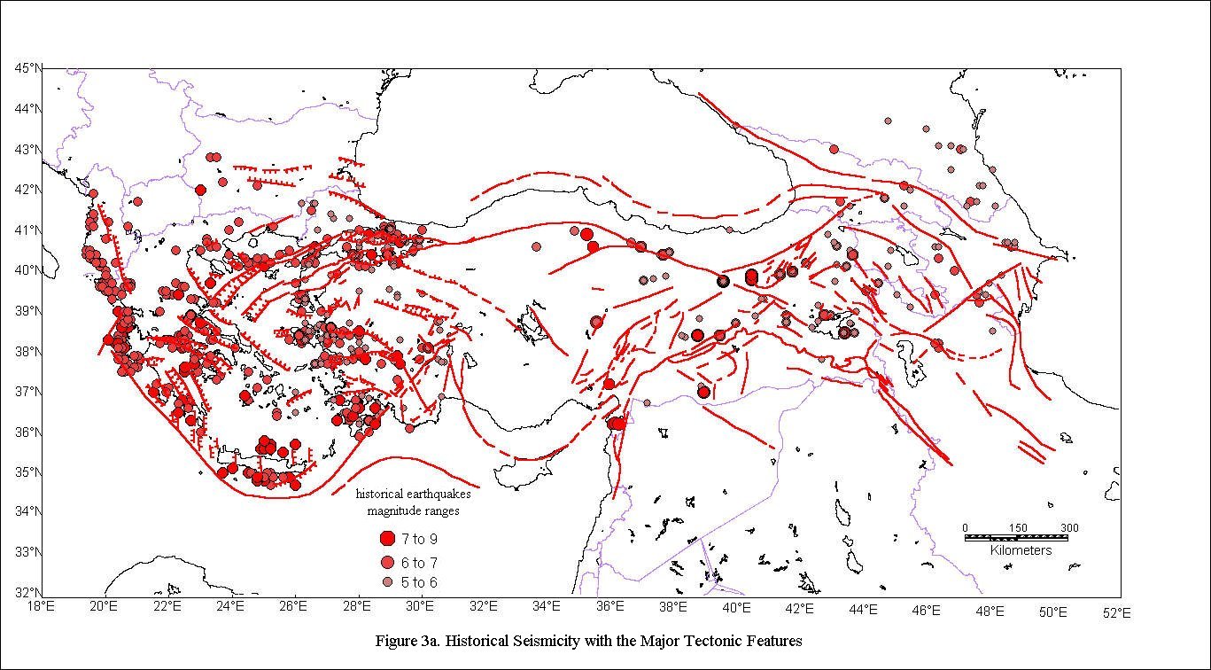
SEISMICITY
Various catalogues of historical and instrumental seismicity of the region have been analyzed and combined to form a historical seismicity map of the region, to be used afterwards in the delineation of the seismic source zones. For source seismicity assessments the seismicity data has been considered in two categories: Pre-1963, and Post-1963. The Pre-1963 data is considered complete for earthquakes M >5.5, whereas Post-1963 data is considered complete for earthquakes of M> 4.0.
There are several earthquake catalogues available for the region from both national and international sources. Turkish references include those compiled by Kandilli Observatory and Earthquake Research Institute of Bogazici University (Istanbul), Istanbul Technical University (Istanbul) and the General Directorate of Disaster Affairs of the Turkish Government (Ankara). International sources are: Ambraseys (1988), PDE/NEIC (Preliminary Determination of Epicenters/National Earthquake Information Center), ISC (International Seismological Center), ISS (Bulletin of International Seismology Summary), BCIS (Bureau Central International Sismologique), EMSC (European-Mediterranean Seismological Center), CNSS (US Council of the National Seismic System), Unified Catalogue of Earthquakes of Northern Eurasia. Instrumental part 1900-1990) (Instrumental data: under supervision of N. V. Kondorskaya, macroseismic data: under supervision of N. V. Shebalin, INTAS Ct 94-1644, 1998) and The Earthquakes of Greece (Papazachos in 1997).
In the traditional probabilistic seismic hazard assessment (Cornell, 1968) chosen by GSHAP, independent events must be treated. To satisfiy this requirement earthquakes in the study region needs to be de-clustered by removing foreshocks and aftershocks from the seismicity databases in order to obtain a Poissonian distribution. In this study, mainly earthquakes with M >5.5 were used for recurrence relations, therefore the removal of fore- and after-shocks was not necessary to ensure Poissonian distribution, since fore- and after-shocks are seldom of greater magnitude. In addition, for Turkey it was observed that removal of the fore- and aftershocks did not produce a significant difference in the analytical results, except in some areas where the earthquakes cause long series of aftershocks, like North Anatolian Fault Zone, and some parts of the Aegean Region, which were considered insignificant once the earthquakes with M < 5.5 earthquakes are eliminated for the assessment of recurrence relationships.
The seismicity data from different catalogs were provided in different magnitude scales. For numerous earthquakes there were more than one value, sometimes in different magnitude scales, taken from different sources. This was quite beneficial for comparing the magnitude scales. In the case of older earthquake records (roughly prior to 1970), the types of magnitudes were often not defined. However, after comparing those magnitudes with other magnitude scales when both were available, it was observed that the values in undefined magnitude scales corresponded best with Ms (surface wave magnitude) values. The moment magnitude M was used as the general magnitude unit because as suggested by various researchers the use of moment magnitude avoids the "saturation" of the more traditional band-limited magnitude measures at large seismic moments and, therefore is a better measure of the true size of an earthquake, and as described in the following chapters moment magnitude is recommended to be used with the attenuation relationships.
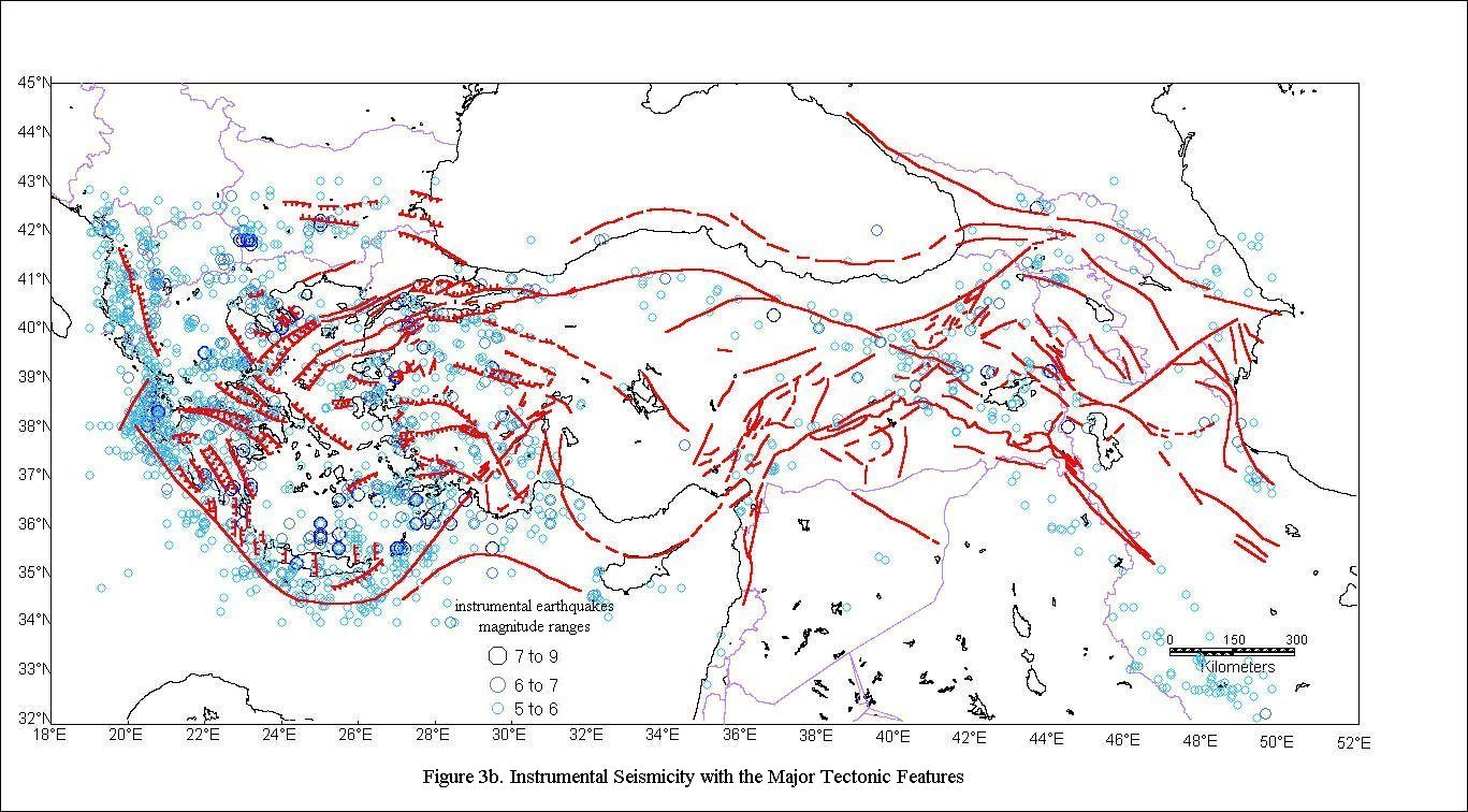
As representative plots of seismicity, the epicentral distribution of
the Pre-1963 and Post-1963 eartquakes are are presented in Figures
3a and Figures 3b.
SEISMIC SOURCE ZONATION
A seismic source zone is defined as a seismically homogenous area, in which every point within the source zone is assumed to have the same probability of being the epicenter of a future earthquake. An ideal delineation of seismic source zones requires a complete comprehension of the geology, tectonics, paleoseismology, historical and instrumental seismicity, and other neotectonic features of the region under study. However, it is not always possible to compile detailed information in all these fields for the majority of the world. Thus, frequently, seismic source zones are determined with two fundamental tools; a seismicity profile and the tectonic regime of the region under consideration. Although seismic source zonation is a widely used methodology to determine earthquake hazard, it is not the only approach. Since delineation of the seismic source zones still remains rather subjective, at present researchers (e.g. Frankel, 1995) are suggesting other methods for evaluating seismic hazard, in order to eliminate the subjectivity of this procedure. This is particularly important in areas where the tectonic structure is very fragmented and the seismicity is diffuse. Whereas in most regions of Turkey, the seismicity is relatively well documented, major faults are often well defined and the source zones are fairly obvious. Hence it is considered adequate to use the conventional method of seismic source zonation for Turkey in this study.
Seismic source zones used in this study are defined according to the principles that: Source boundaries should be defined with regard to the subsequently applied seismic hazard methodology; Sources (or regions) should be defined as areas with seismic characteristic which are as homogeneous as possible; Between sources (regions) of different seismic potential, the boundary should be located close to the highest concentration around the hard core of the most active ones; In areas possessing statistically sufficient number of reliable events, boundaries should be mainly based on seismic data as an expression of tectonic activity and backed up by tectonic arguments; In case of an insufficient number of events or a large number of uncertainties attached to the events, existence of a boundary has been decided by arguments based on the most dominant tectonic or seismic features. In addition to these source zones several background seismicity zones are defined to model the floating earthquakes that are located outside these distinctly defined source zones and to delineate zones where no significant earthquake has taken place.
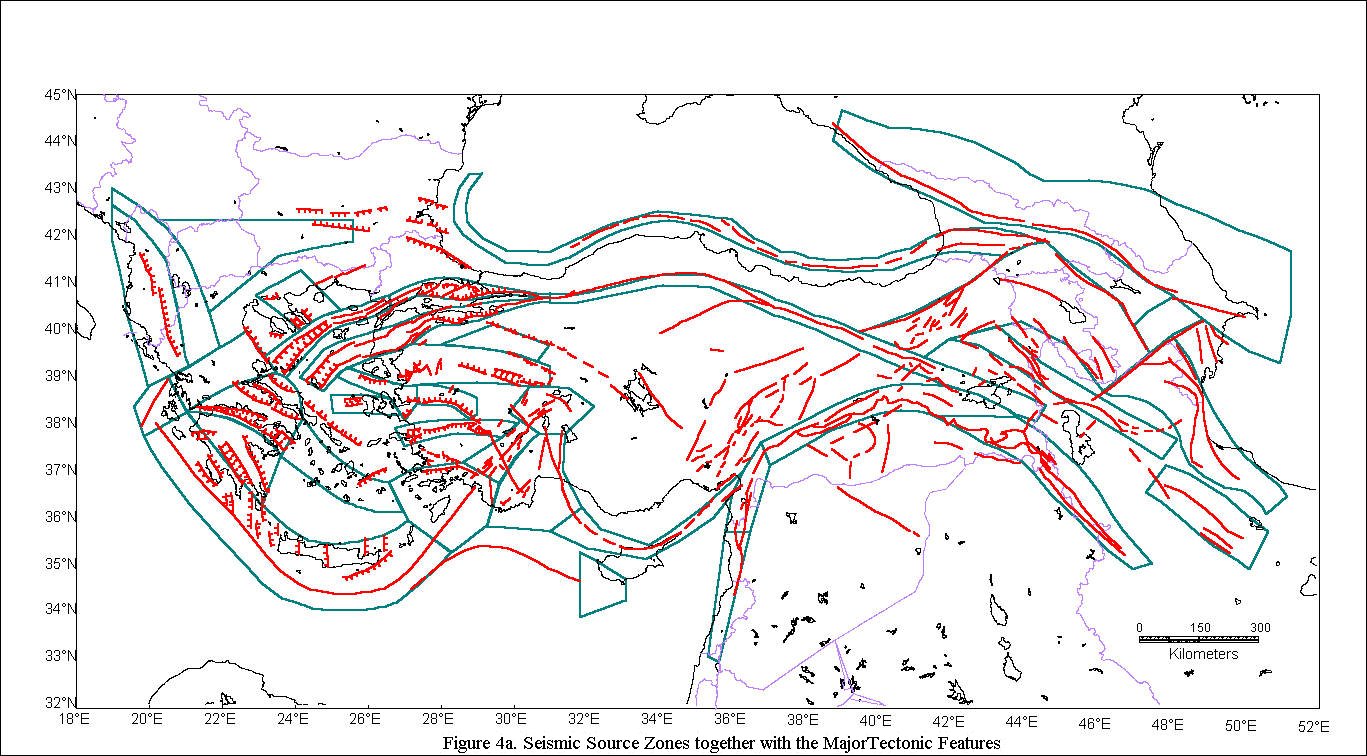
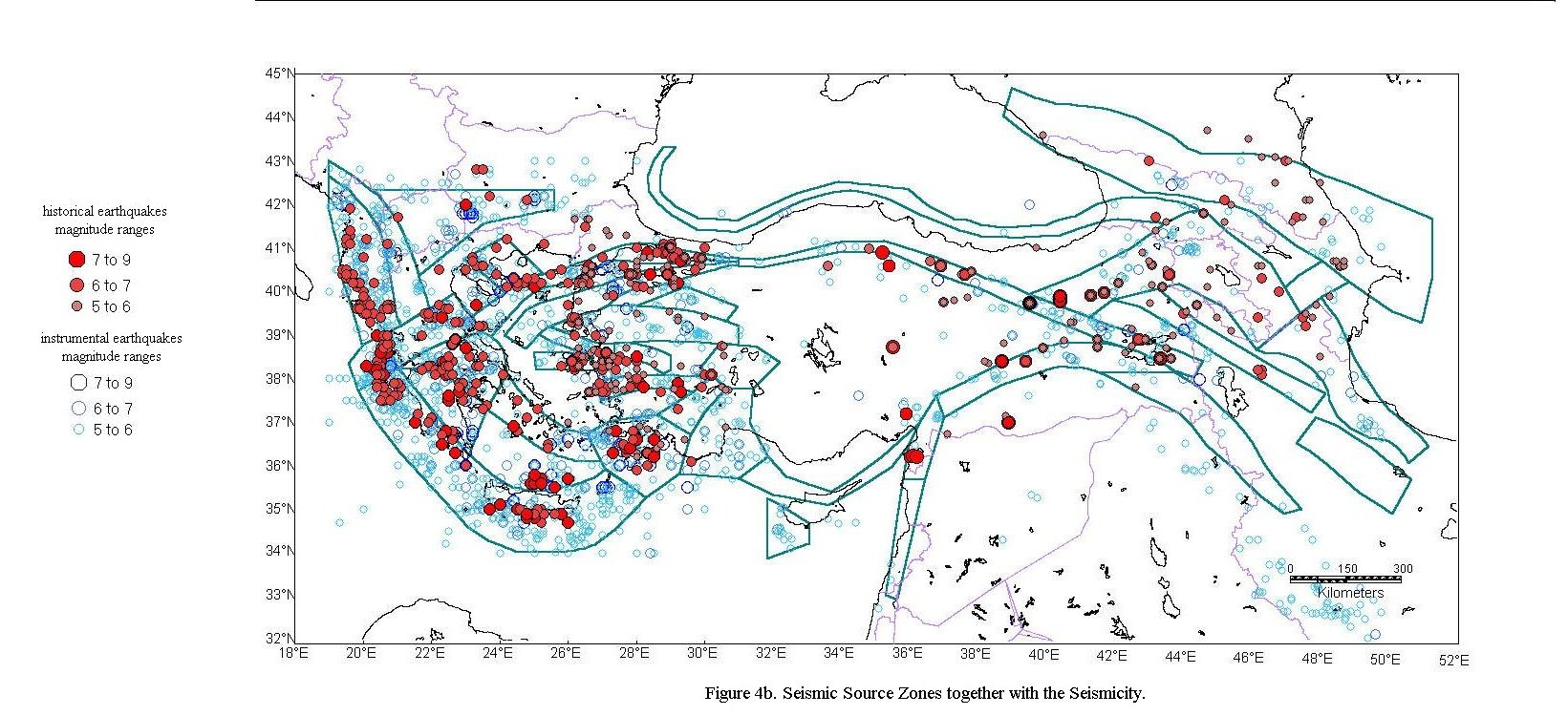
The source zones defined using all the available data and considering the studies and zonations presented by other researchers are given in Figure 4a and Figure 4b as, respectively overlain with the neo-tectonic features and the seismictity. The source zones numbered from 1 to 37 are herein referred to as:
Zone 1) West Ionian
Zone 2) East Ionian
Zone 3) Chalkidiki
Zone 4) Cephalonia
Zone 5) Central Greece
Zone 6) Cretan Arc (Hellenic Arc)
Zone 7) Peloponnese
Zone 8) Gulf of Corinth
Zone 9) Cyclades
Zone 10) Fethiye
Zone 11) Antalya
Zone 12) Burdur
Zone 13) Buyuk and Kucuk Menderes
Zone 14) Chios
Zone 15) Izmir
Zone 16) Gediz
Zone 17) Simav
Zone 18) South Strand of the Anatolian Trough
Zone 19) Northwest Strand of the Anatolian Trough
Zone 20) Northeast Strand of the Anatolian Trough
Zone 21) Sreanogorie
Zone 22) Lakes
Zone 23) Kutahya
Zone 24) Cyprus
Zone 25) SW of Cyprus
Zone 26) NAF
Zone 27) Black Sea
Zone 28) Caucasus
Zone 29) Pambak-Sevan
Zone 30) Arax
Zone 31) EAF
Zone 32) Bitlis-Zargos
Zone 33) Tebriz
Zone 34) Talish
Zone 35) Soltanieh-South Parandak
Zone 36) Hatay (Antioch)
Zone 37) Dead Sea
Source zones from 28 to 35 in Eastern Turkey were obtained from Sesetyan (1997), and the source zone 25 in the Cyprus Region was acquired from Birgoren et. al. (1997).
Detailed description of the seismicity and the neo-tectonics associated with these source zones will be provided in another publication.
To avoid sudden changes in seismicity at source zone boundaries, SEISRISK
III permits an option of to account for earthquake location uncertainty.
Instead of assuming that source zones are homogeneous, that is each point
within a source zone has the same probability of being the epicenter of
a future earthquake. The earthquake location uncertainty allows the assumption
of each point within a source zone being the mean or most likely location
of a future earthquake. A constant location uncertainty of 10km has been
adopted for this study.
RECURRENCE RELATIONSHIPS
The empirical recurrence relationship for earthquakes (Gutenberg and Richter Model. Richter, 1954):
logN=a+bM (2)
where N is the number of the earthquakes above the magnitude M in a given region and within a given period and a and b are regression constants, has been extensively used in many seismicity studies and has also been confirmed to hold for micro-earthquakes. The coefficient a is a constant that is dependent on the location and time of the sample used and b represents a constant thought to be characteristic of the region.
The earthquake catalogues are often biased due to incomplete reporting for smaller magnitude earthquakes in earlier periods. Thus to fit the recurrence relationship to a region, one should choose among using (1) a short sample that is complete in small events or (2) a longer sample that is complete in larger events or (3) a combination of the two data sets to complete the deficient data thereby obtaining a homogeneous data set. A direct attempt to fit these data to a regression relationship may result in quadratic or higher order expressions to accomodate the inherent bias and inhomogeneity of the data. In the method used in this study, an artificially homogeneous data set is simulated through the determination of the period over which the data in a given magnitude group are completely reported (Stepp, 1973).
It is known that the use of fault segmentation models, where the magnitude of the characteristic event on each segment is determined using the relations between surface rupture length and moment magnitude, provides a better description of the recurrence rates for North and East Anatolian Faults. We tried to obtain the geologic slip rate and a characteristic magnitude of and derive the a-value by requiring the moment rate to equal the annual moment sum of earthquakes. For a-priori values of b based on the regional seismicity, the a values were somewhat less than those obtained on the basis of the Stepp (1973) procedure. For the sake of uniformity, less uncertainty and conservation we used the recurrence relationships based on the Gutenberg and Richter model.
As inpot to the SEISRISK III software we have entered the earthquake
occurrence rates simulated on the basis of the log-linear least-squares
regression anlysis of the seismicity data. For all source zones the slope
(b-value) of the frequency-magnitude relationship varies between 0.7 and
1.1, with most zones having values around 0.8. Obviously depending on
the size and the seismicity of the source zone considered, a-values show
a greater variation between 0.5 and 6.
ATTENUATION RELATIONSHIPS
Assessment of the seismic hazard requires an appropriate strong-motion attenuation relationship, which depicts the propagation and modification of strong ground motion as a function of earthquake size (magnitude) and the distance between the source and the site of interest. The scarcity of the local strong-motion acceleration data in Turkey makes it unavoidable to either define the attenuation on the basis of local intensities or borrow the already developed acceleration attenuation relationships based on foreign data. Erdik et. al. (1985) showed that the attenuation relationships based on western American strong-motion data satisfactorily agree with the strong-motion data obtained from Anatolian earthquakes. For peak ground acceleration (PGA) we used the following attenuation relationships with equal weight.
Attenuation Relationships Developed by Campbell (1997)
(Empirical Near-Source Attenuation Relationships for Horizontal and Vertical Components of Peak Ground Acceleration, Peak Ground Velocity, and Pseudo-Absolute Acceleration Response Spectra, by Kenneth W. Campbell,Seismological Research Letters, 68, January/February, 1997). Campbell (1997) developed a set of attenuation relationships to predict free-field horizontal and vertical components of peak ground acceleration (PGA), peak ground velocity (PGV), and 5%-damped pseudo-absolute acceleration response spectra (PSA). He used 226 recordings of 30 earthquakes from worldwide active tectonic regions for the horizontal components of spectral acceleration . He restricted the recordings used to near-source distances, in order to minimize the influence of regional differences in crustal attenuation and to avoid the complex propagation effects observed at longer distances during earthquakes. The attenuation relationships are considered to be appropriate for predicting free-field amplitudes of horizontal ad vertical components of strong ground motion from worldwide earthquakes of moment magnitude (M) greater than or equal to 5 and sites with distances to seismogenic rupture less than or equal to 60 km in active tectonic regions.
Attenuation Relationships Developed by Boore et. al. (1997)
(Equations for Estimating Horizontal Response Spectra and Peak Acceleration from Western North American Earthquakes: A Summary of Recent Work, by David M. Boore, William B. Joyner, and Thomas E. Fumal,Seismological Research Letters, 68, January/February, 1997). Since first publishing their attenuation relationships in 1981, Boore et. al. have revised their relationships many times. Boore et. al. (1997) proposed attenuation relationships for random horizontal peak ground acceleration and pseudo-acceleration response spectra for shallow earthquakes in western North America. The equations give ground motion in terms of moment magnitude, distance, and site conditions for strike-slip, reverse-slip, or unspecified faulting mechanisms. Site conditions are represented by the shear velocity averaged over the upper 30 m.
Attenuation Relationships Developed by Sadigh et. al. (1997)
(Attenuation Relationships for Shallow Crustal Earthquakes Based on California Strong Motion Data, by K. Sadigh, C.-Y. Chang, J.A. Egan, F. Makdisi, and R.R. Youngs,Seismological Research Letters, 68, January/February, 1997). Sadigh et al. (1997) presents attenuation relationships for peak acceleration and response spectral accelerations from shallow earthquakes. The relationships are based on strong motion data primarily from California earthquakes. Relationships are presented for strike-slip and reverse faulting earthquakes, rock and deep soil deposits, earthquakes of moment magnitude M 4 to 8+, and distances up to 100 km.
In the SEISRISK III software the attenuation function is inputted as a table of values of the chosen ground motion parameter as a function of magnitude and distance. The software allows the modeling of acceleration variability. Rather than assuming a single value of acceleration resulting from earthquakes at each magnitude and distance, a range of accelerations lognormally distributed with standard deviation. The Cornell (1968) methodology used in SEISRISK III formulation, computes the hazard at each site of the study region by discrete summation of the individual contributions from the mass center of the elementary cells in source zone considered. It should be noted that, this distance may or may not correspond exactly to the distance definitions used in the above attenuation relationships.
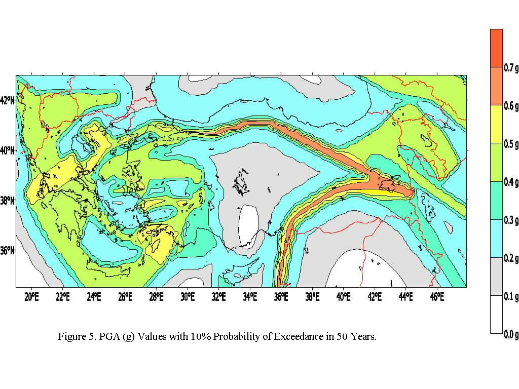
SEISMIC HAZARD MAPS: RESULTS AND DISCUSSION
The seismic hazard has been computed using the computer code Seisrisk III (Bender and Perkins, 1987), with areal source settings. The final maps were done over a 0.05° X 0.05° grid, for a total number of more than 184,800 computation nodes.
The calculations were performed using three equally weighted attenuation relationships (Campbell, 1997; Boore et. al., 1997; and Sadigh et al., 1997) for competent or rock sites, sites with shear wave propagation velocity greater that 700m/s, and with undifferentiated source mechanisms, whichever appropriate and applicable. The log-normal, magnitude-independent standard deviation values associated with these attenuation relationships are utilized in the computations. The use of these three attenuation relationships with equal weigthts follows that used in Frankel et al. (1996) for Western United States.
In line with the GSHAP standarts, the seismic hazard map in terms of iso-horizontal PGA contours corresponing to 475 year return period (10% probability of exceedance in 50 years) and competent free-field ground (rock site or sites with shear wave propagation velocity greater 700m/s) is provided in Figure 5.
The following characteristics of these maps should be noted:
The PGA values denote maximum horizontal accelerations on competent soil. With soil deposits of soft- and medium-stiff sands and clays of appreciable depth the ground accelerations will be different than those indicated on these hazard maps.
In the delineation of the seismic sources the geological boundaries of the tectonic elements and their immediate vicinity have been considered. The seismic hazard near the source boundaries is directly and strongly affected by the changes in the delineation of these boundaries.
The recurrence relationships used in the preparation of these maps are based on artificially complemented data set that can account for the small magnitude data deficiencies in earlier reporting periods. The net effect of such a procedure reflects itself in the increase of the slopes of the log-linear recurrence relationships and in the decrease of the relative number of earthquakes at the high magnitude end. The effect of such an approach on the hazard maps can be appreciable for the return period considered.
In the seismic source regionalization methodology utilized in this map, it has been tacitly assumed that in the future the locations of major seismic activity will be essentailly limited to seismic zones, as it has been the case over the course of the recorded history. In the past, certain parts of these source zones remained locked for considerable periods of time and this indeed may be the case in future. However, there is no conceivable physical model that can accurately predict the locality and inception and termination times of these locking periods and the best one can do is to be on the conservative side and assume that these seismic sources will remain active in the future.
The seismic hazard is based on the derived recurrence relationships
which represents extrapolations into the future assuming that the rate
of the seismic activity observed in the past will essentially repeat itself
in the future. Although a decrease in the seismic activity in certain seismotectonic
regions can cause an overestimation of the seismic hazard the opposite
can not be tolerated and is believed to be accounted.
ACKNOWLEDGEMENTS
The work reported herein represents a selected sub-section of the graduate studies conducted by Hafez Keypour (1992), Karin Sesetyan (1997), Tuna Onur (1997), Gulum Birgoren et.al.(1997) and Yesim Alpay Biro (1999) in the Department of Earthquake Engineering of Bogazici University. A comprehensive report encompassing these studies is in preparation. The assistance of Talhan Biro in resolving several problems with the software needs to be acknowledged. We are grateful for all the assistance rendered by Professor Aykut Barka for allowing us to use his tectonic maps and interpretations and for providing guidance in the delineation of seismic source regions. We also thank Professor Domenico Giardini in encouraging us to write this paper.
REFERENCES
Algermissen, S.T., Perkins, D.M., Isherwood, W., Gordon D., Reagor, G. and Howard, C., 1974. UNESCO Survey of the Seismicity-Seismic Risk Evaluation of the Balkan Region. U.S. Geological Survey, Golden, Colo., 32 pp.
Alsan, E., 1972. Magnitude and time distributions of earthquakes in Turkey. Bull. Int. Inst. Seismol. Earthquake Eng., 7: 1-10.
Ambraseys, N.N. (1988), Engineering Seismology, Earthquake Engineering and Structural Dynamics, Vol.17, pp.1-105, 1988.
Barka, A. A., "The North Anatolian Fault Zone," Annales Tectonicae, Special Issue, Supplement to Vol. VI, 1992.
Bath, M., 1979. Seismic risk in Turkey; a preliminary approach. Tectonophysics, 54: T9-T16.
Bender, B., and D. M. Perkins, "SEISRISK III: A Computer Program for Seismic Hazad Estimation," USGS Bulletin 1772, U. S. Government Printing Office, Washington, 1987.
Birgoren, G., N. Apaydin, Onur, T., "Probabilistic assessment of earthquake hazard in Cyprus in terms of spectral amplitudes", Abstract #1801, IASPEI August 18-28, 1997, Thessaloniki, Greece, 1997.
Biro, Y. A., "Seismic Hazard in the Aegean and Surrounding Area", MSc. Thesis, Bogazici University, KOERI, 1999.
Boore, D. M., W. B. Joyner, and T. E. Fumal, "Equations For Estimating Horizontal Response Spectra and Peak Acceleration From Western North American Earthquakes: A Summary of Recent Work," Seismological Research Letters, Volume 68, Number 1 January, February 1997.
Campbell, K. W., "Empirical Near Source Attenuation Relationships For Horizontal and Vertical Components of Peak Ground Acceleration, Peak Ground Velocity, and Pseudo Absolute Acceleration Response Spectra," Seismological Research Letters, Volume 68, Number 1 January, February 1997.
Cornell, C. A., "Engineering Seismic Risk Analysis," BSSA, Vol. 58, No. 5, pp. 1583-1606, 1968.
· Dewey, J. F., W. C. Pitman, W. B. F. Ryan, J. Bonnin, "Plate Tectonics and the Evolution of the Alpine System", Geological Society of America Bulletin, Vol. 84, pp. 3137-3180, 1973.
Erdik, M. and Oner, S., 1982. A rational approach for the probabilistic assessment of the seismic risk associated with the North Anatolian Fault. In: A. Is,lkara and Vogel (Editors), Multi-disciplinary Approach to Earthquake Prediction. Vieweg, Brauschweig-Wiesbaden, pp. 115-127.
Erdik, M., Doyuran, V., Yucemen, S., Gulkan, P. and Akkas, N., 1982. A probabilistic assessment of the seismic hazard in Turkey for long return periods. Proc. 3rd Int. Earthquake Microzonation Conf., Seattle, Wash, pp. 1261-1272.
Erdik, M., V. Doyuran, N. Akkas, P. Gulkan, "A Probabilistic Assessment of the Seismic Hazard in Turkey", Tectonophysics, 117, pp. 295-344, 1985.
· Frankel, A. (1995). Mapping seismic hazard in the Central and Eastern United States, Seism. Res. Letts, v.,66, no. 4, pp. 8-21.
Frankel, A., Mueller, C., Perkins, D., Leyendecker, E.V., Dickman, N., Hanson, S., Hopper, M., National Seismic-Hazard Maps: Documentation June 1996, Open-File Report 96-532, USGS, Denver, 1996.
Gencoglu, S. and Tabban, A., 1973. Unpublished Earthquake Catalogue Compilations for Turkey. Earthquake Research Division of the Ministry of Reconstruction and Resettlement, Ankara.
Giardini, D. and P. Basham, "The Global Seismic Hazard Program", Annali di Geofisica, Vol. XXXVI. N.3-4, June-July 1993.
Gutenberg, B. and C. F. Richter, Seismicity of the Earth and Associated Phenomena, 2nd Edition, Princeton: Princeton University Press, 1954.
Gulkan, P., A. Kocyigit, M.S. Yucemen, V. Doyuran, and N. Basoz, "En son verilere gore hazirlanan Turkiye deprem bolgeleri haritasi", Report No: METU/EERC 93-1, January 1993.
Hattori, S., 1979. Seismic risk maps in the world, 11. Bull. Int. Inst. Seismol. Earthquake Eng., 17: 33-96.
INTAS Ct 94-1644 (1998) S. Balassanian, D. Giardini, A. Gassanov, T. Chelidze, B. Pustovitenko, T. Ashirov, M. Ghafory-Ashtiany, M. Erdik, V. Ulomov, N. Kondorskaya, V. Trifonov, G. Molchan, V. Shenk, D. Mayer-Rosa, M. Stucchi, G. Grunthal, SEISMIC HAZARD ASSESSMENT FOR THE CAUCASUS TEST AREA, Steering Committee of the IASPEI-GSHAP-INTAS Test Area for Seismic Hazard Assessment in the Caucasus -
Keypour,H., " A Probabisitic Assessment of the Seismic Hazard in Iran", MSc. Thesis, Bogazici University, 1992.
McGuire, R. (editor), The Practice of Earthquake Hazard Assessment, International Association of Seismology and Physics of the Earth and European Seismological Commission, 1993.
McGuire, R., "Computations of Seismic Hazard," Annali di Geofisica, Vol. XXXVI. N.3-4, pp. 181-200, June-July 1993.
McKenzie, D.P., 1972. Active tectonics of the Mediterranean region. Geophys. J.R. Astron. Soc., 30: 109-185.
Muir-Wood, R., "From Global Seismotectonics to Global Seismic Hazard," Annali di Geofisica, Vol. XXXVI. N.3-4, pp. 153-168, June-July 1993.
Papazachos, B. and Papazachou, C., The Earthquakes of Greece. Ziti Publ., Thessaloniki, 356 pp., 1997.
Richter, C.F., 1958. Elementary Seismology. Freeman, San Francisco, Calif.
Sadigh, K., Chang, C.-Y., Egan, J. A., Makdisi, F., Youngs, R.R., "Attenuation Relationships for Shallow Crustal Earthquakes Based on California Strong Motion Data" Seismological Research Letters, Volume 68, Number 1 January, February 1997.
Sesetyan, K., "A Probabilistic Assessment of the Seismic Hazard in the Caucasus in Terms of Spectral Values ", MS. Thesis, Bogazici University, 1997, 126 p.
Shebalin, N.V., Karnik, V. and Hadzievski, D. (eds.), 1974. Catalogue of earthquakes of the Balkan region. I, UNDP- UNESCO Survey of the seismicity of the Balkan region. Skopje, 600 pp.
Stepp, J.C. (1973), Analysis of Completeness of the Earthquake Sample in the Puget Sound Area, in Contributions to Seismic Zoning, NOAA Tech. Report, ERL 267-ESL30, Washington, D.C.
Yarar, R., Ergunay, O., Erdik, M. and Gulkan, P., 1980. A preliminary probabilistic assessment of the seismic hazard in Turkey. Proc. 7th World Conf. Earthquake Eng., Istanbul, pp. 309 316.