PARTICIPANTS:
Observatorio de San Calixto, Bolivia
Instituto de Investigaciones en Geociencias, Minería y Química (INGEOMINAS), Colombia
Escuela Politécnica de Quito (EPN), Ecuador
Instituto Geofísico del Perú (IGP)
Fundación Venezolana de Investigaciones Sismológica (FUNVISIS),Venezuela
GeoforschungsZentrum (GFZ), Germany
Institute of Geophysics, ETH, Switzerland
Istituto Nazionale di Geofisica (ING), Italy.
1. Introduction
2. Tectonic setting of the Northern
Andes
3. Seismicity
3.1. Earthquake Catalogue For The Andean Region
3.2 Magnitude Homogenization
3.3 Removal of Dependent Events
4. Earthquake Source Zones
4.1 Earthquake Source Zones Geometry
4.2 Seismic Source Characterization
5. Strong Ground Motion Relations
6. Hazard Computation Method
7. Discussion of Hazard Results
8. References
SEISMIC HAZARD ASSESMENT FOR THE
NORTH ANDEAN REGION
1. Introduction
The results presented in this summary
were achieved during the execution of the Pilot Project for Regional
Earthquake Monitoring and Seismic Hazard Assessment, referred
to as PILOTO. This project, proposed under the initiative of the
Centro Regional de Sismología para América Latina
(CERESIS) and supported by the European Community, was implemented
over 2 years (1995-1997) and joined research organizations of
4 countries of the European-Mediterranean area (EUME) and 5 countries
from the Andean Pact (JUNAC). The main goals of the project related
to hazard assessment were to complete the compilation of the instrumental
and historical earthquake catalogue for the JUNAC area, and to
produce a regional seismic hazard assessment map in the JUNAC
region adopting a common approach based on: (i) joint work in
multidisciplinary research and data, (ii) the analysis of seismogenic
structures without political boundaries, and (iii) training a
group of young scientists of the JUNAC countries in hazard assessment
matters.
In this part of the project research
was conducted for the following institutions: from the JUNAC countries
Observatorio de San Calixto, Bolivia; Instituto de Investigaciones
en Geociencias, Minería y Química (INGEOMINAS),
Colombia; Escuela Politécnica de Quito (EPN), Ecuador;
Instituto Geofísico del Perú (IGP), and Fundación
Venezolana de Investigaciones Sismológica (FUNVISIS),Venezuela;
from the EUME countries: GeoforschungsZentrum (GFZ), Germany;
Institute of Geophysics, ETH, Switzerland; and Istituto Nazionale
di Geofisica (ING), Italy.
The scope of the research and the strategy
followed in order to achieve these tasks were defined among the
PILOTO participants. It was agreed that the development of the
seismic hazard map would be essentially an integration exercise
aimed on building a common set of concepts, in defining jointly
a seismic source zoning without political boundaries and in integrating
past and ongoing national and regional initiatives. In no way
this map would constitute an official seismic hazard map for the
region, given that the official institution for seismic affairs
in the region is CERESIS, the Regional Seismic Center for South
America. Detailed description of the procedures and results achieved
can be consulted in Piloto Project, 1997.
2. Tectonic setting of the Northern Andes
The North Western region of South America is characterized by two contrasting provinces from the geologic and geographic point of view: a relatively stable, low topography, region known as the South American platform, involving Central and Southern Venezuela, and Eastern Colombia, Ecuador, Peru and Bolivia; and a second region to the west, active and deformed, associated to the mountain chain of the Andes. The Andes extends as a single chain along the continental margin from Central Chile to Southern Bolivia where the Altiplano is developed up to central Perú. From there north to Ecuador the Andes becomes again a single chain and in Colombia it splits in three chains, the easternmost continuing into Venezuela.
Tectonics of the region has been interpreted in terms of the convergence of the Caribbean, Nazca and South American plates. Interaction of these plates results in the deformation of the continental margin forming the belt of folded mountains that now constitute the ranges of the Andes. Relative motion between the Caribbean and South American plates at a rate of 14 mm/yr. in direction ESE, (Freymuller et al., 1993) is absorbed mainly along an extended transform system conformed by the Boconó, Morón and El Pilar Faults in Venezuela and the Caribbean Deformed Belt in the coastal margin in Colombia.
Subduction of the oceanic Nazca plate under the South America plate in the Northern Andes takes place along the Colombia-Ecuador-Peru trench. These two plates converge in a N80ºE direction at a rate of 78 mm/yr. (de Mets et al. 1990) giving rise to numerous great earthquakes along the margin. The subducted plate geometry inferred from the intermediate and deep seismicity indicates variations along strike associated to segmentation and buckling of subduction (Pennington,1981; Jordan et al., 1983; Norabuena et al., 1994). The changes in geometry of subduction correlate to the presence and absence of the volcanic arc. Zones of subhorizontal subduction exists with the absence of volcanism, while normal angle subducting plate geometry is present with active volcanic arc.
Besides activity associated to plate boundaries, convergent tectonics originates active internal deformation in the Andean block evidenced by neotectonic activity and seismicity concentrations along the interandean valleys and coastal fault systems.
The relative motion between Caribbean,
Nazca and South American plates is accommodated along the margins
defining the regions where the major earthquakes occur. Nevertheless,
the Andes represents a zone of wide spread deformation where the
remaining convergence is adjusted. The Andes defines a zone of
compression characterized by reverse faulting on the foothills
(e.g. Subandean, Colombian Llanos foothills) roughly perpendicular
to the vectors of plate convergence, strike slip faults (e.g.
Oca Fault, Pallatanga Fault) and some normal faults on the high
cordillera (e.g. Cordillera Blanca Fault). Seismicity clearly
defines the deformation front of the previously mentioned zones.
3. Seismicity
3.1. Earthquake Catalogue For The Andean Region
The earthquake catalogue for the JUNAC countries (Bolivia, Colombia, Ecuador, Peru and Venezuela) used in PILOTO project was extracted from the Catalogue of Earthquakes for South America-SISRA project (CERESIS, 1985), hereon called CERESIS catalogue, which has been updated to December 1991 (CERESIS, 1996).The information on this was compiled by the representing institutions for CERESIS in each country. Since almost all the Andean institutions participating in PILOTO (excepting IGP) were the same ones that prepared the respective catalogues for CERESIS it was natural to use it in the project. In seismic hazard calculations the seismic data from Chile and Argentina, in the limits with Perú and Bolivia were included to have more realistic values of hazard.
A complete description of the hypocenter catalogue can be found in CERESIS, 1985, and Tanner and Shepherd, 1997. The following describing paragraphs were summarized from these two documents in order to describe the contents of the catalogue and the criteria taken into account while compiling it.
The catalogue spans from historical to instrumental events, including instrumental data from local agencies, observatories, stations and universities. It covers a time period beginning with the earliest known historical event for each country and ending December 1991, being the earliest event included from 1471. A total number of 18137 earthquakes are reported in the catalogue, all magnitudes included, for a time period of about 500 years. The completeness of the catalogue varies over time, being relatively incomplete for early historical events and much more complete for recent ones. The lower magnitude cut-off has been designated as 4.5 mb. Smaller events have not been vigorously eliminated, particularly since many events have no reported or calculated magnitudes. The catalogue, however, is much less complete for events below magnitude 4.5 mb. . A two letter country code together with a five digit identifying number provide a unique reference for each event.
Quality factors for time, epicenter and depth has been associated for most of the events. Quality factors used by other sources for hypocenter data were converted to the factors defined for the catalogue. Space is provided for four magnitude values. The first is an mb. magnitude, followed by an Ms magnitude. The other two may be additional mb. or Ms magnitudes, other reported magnitudes, magnitudes derived from intensity data, or magnitudes converted from one scale to another. All intensities are listed in either the Modified Mercalli (MM) or the MSK scale.
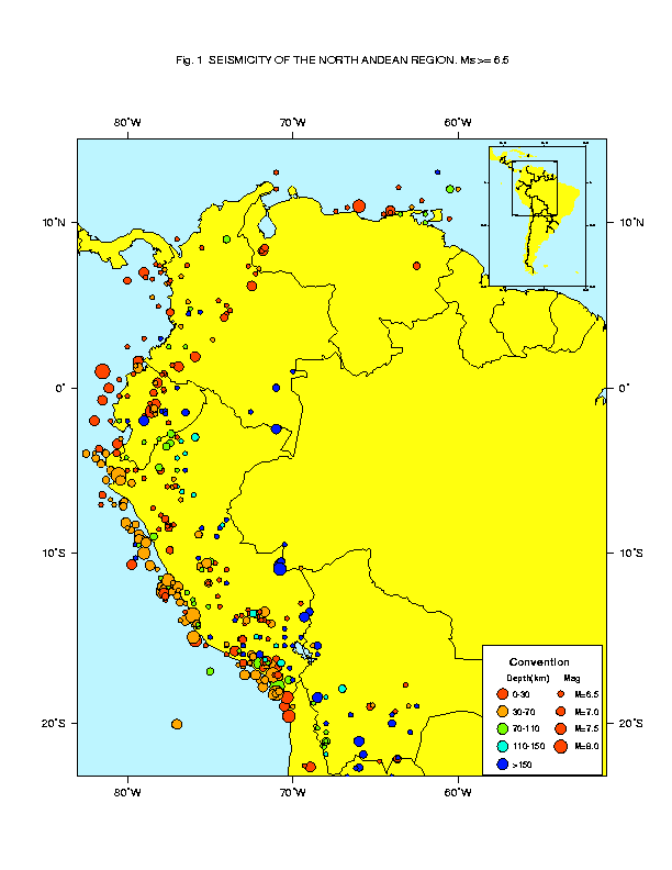
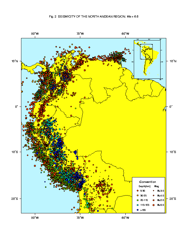
In Figure 1 are plotted the events with
magnitude equal or over 6.5 contained in the catalogue. The same
is done in Figure 2 for events with magnitude lower than 6.5.
For this catalogue a Gutenberg-Richter law gives a return period
of 45 years approximately for events with magnitude over 8.0.
Figure 1 Events with magnitude equal or over 6.5 in the North Andean region, extracted from CERESIS, 1996.
Figure 2 Events with magnitude less than 6.5 in the North Andean region, extracted from CERESIS, 1996.
3.2 Magnitude Homogenization
Given the importance of having a uniform and homogeneous parameter to compare size of earthquakes in the process of seismic hazard computations, the catalogue was examined in detail, magnitudes were homogenized to surface magnitude, Ms, and events without magnitude or with zero magnitude were removed.
To convert magnitudes different from Ms, to Ms,, linear regressions between events with both magnitudes reported were calculated. The procedure was as follows:
i) Examination of type and quality of magnitude information for each country since they have been compiled independently. As result of this examination 20135 events were removed from the original catalogue, as shown in Table 1:
Table 1
| Removed | |||||||
| Final |
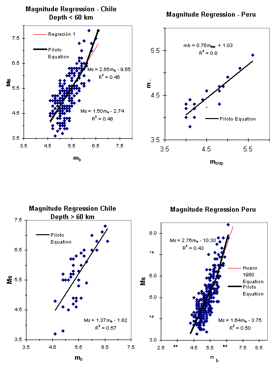
ii) Plotting histograms for the four types of magnitude reported in the CERESIS catalogue (mb=body wave magnitude, Ms=surface wave magnitude, M1 and M2 other magnitudes) for each country.
iii) Calculation of regression equations and comparison with previous equations used in the CERESIS catalogue (Figure 3).
iv) Conversion of magnitudes to Ms under the following criteria:
1. For events with reported instrumental Ms magnitude that value is preserved.
2. For events with reported maximum epicentral intensity Io, Ms is calculated using the standard Gutenberg and Richter equation (Gutenberg and Richter, 1956):
Ms = 1 + 2/3*Io
except for Peru, where Huaco and Rodriguez's relations were used (CERESIS,1985):
3. For events with mb
magnitudes reported, Ms is calculated using
the regression equations derived in iii) for each country:
| Argentina | Ms = 1.116 * mb - 1.067 | mb < 5.8 |
| Bolivia | Ms = 1.786 * mb - 4.232 | |
| Colombia | Ms = 1.33 * mb - 2.13 | mb < 5.2 |
| Ms = 1.77 * mb - 4.42 | mb 5.2 | |
| Chile | Depth < 60 km: | |
| Ms = 1.503 * mb - 2.737 | mb < 6.0 | |
| Ms = 2.649 * mb - 9.653 | mb 6.0 | |
| Depth 60 km: | ||
| Ms = 1.369 * mb - 1.817 | ||
| Ecuador | Ms = 1.157 * mb - 0.873 | |
| Perú | mb = 0.757 * mLSP + 1.027 | |
| Ms = 1.644 * mb - 3.753 | mb < 5.9 | |
| Ms = 2.763 * mb - 10.301 | mb 5.9 | |
| Venezuela | mb = 0.742 * mTRN + 1.172 | |
| Ms = 1.116 * mb - 1.067 | mb < 5.8 | |
| Ms = 2.714 * mb - 10.369 | mb 5.8 |
For the Chilean catalogue best adjustment
was obtained grouping the events in two ranges of depth: 0 to
60 km and greater than 60 km.
Figure 3a. Ms vs. mb regression equations for Argentina, Colombia, Bolivia and Ecuador. Thin lines correspond to previous equations (CERESIS,1985), thick line to PILOTO equation.
Figure 3b. Ms vs. mb regression equations for Chile and Peru. Thin lines correspond to previous equations (CERESIS,1985), thick line to PILOTO equation.
3.3 Removal of Dependent Events
To fulfill the requirements of a Poisson distribution, assumed as representative of the earthquake time occurrence distribution, removal of dependent events was performed. Since most of the dependent events are aftershocks, an algorithm was developed to remove them based on Maeda's relation (1996). These relations establish spatial and temporal criteria to eliminate aftershocks from the original data as follows:
| as for distance: | L 10(0.5Mm-1.8) |
| as for time: | t 10(0.17+0.85(Mm-4.0))/1.3 - 0.3 |
| as for magnitude: | Ma < Mm - 1.0 Ma < Mm - 1.0 |
where L, t , Mm y Ma represent
an epicentral distance from the main shock, time in days from
occurrence of a main shock, magnitude of a mainshock, and that
of an aftershock, respectively. These relations were derived from
Utsu's (1970) and consider the exponential decaying in number
and magnitude of aftershocks.
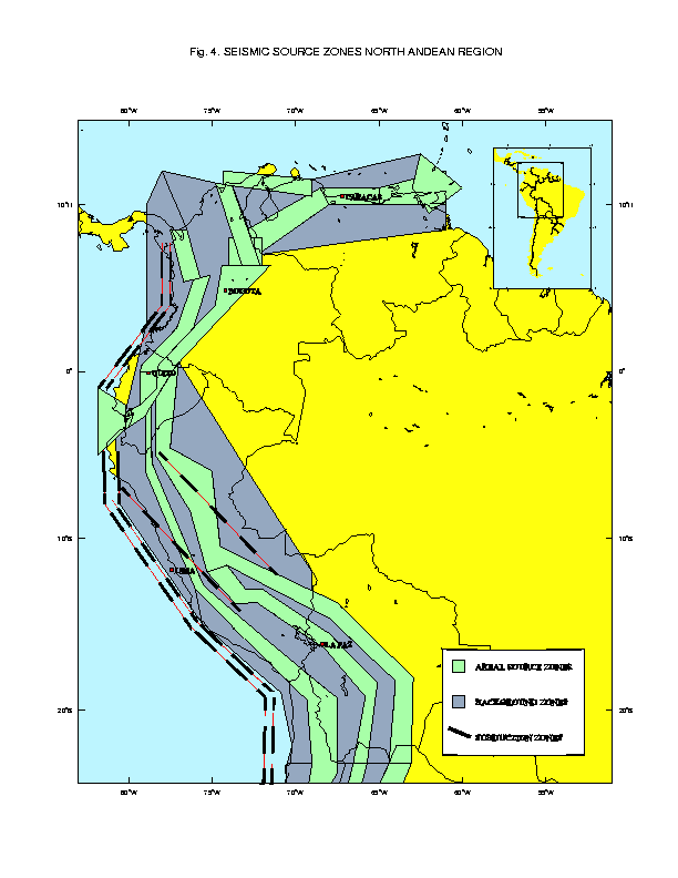
4. Earthquake Source Zones
4.1 Earthquake Source Zones Geometry
A seismic source zoning for the PILOTO Project region was produced joining the data from the complete and homogenized earthquake catalogue, the geological input (particularly from national active fault maps) and geodynamic models. Qualified judgment and discussion between regional experts during the Second Workshop on Hazard Assessment (Quito, June 1997) played an important role in sources definition.
In the North Andean region four different seismotectonic environments were identified: seismic subduction zones, crustal seismic zones, transcurrent-transformant zones and volcanic seismogenic zones
Seismic subduction zones
The following geologic features were considered in the definition of the zones:
i) Tectonic features in the oceanic plate: Nazca Cordillera, Mendaña Fracture zone, Carnegie Cordillera.
ii) Active volcanism at Southern Peru, Northern Chile, Northern Ecuador and Colombia.
iii) Contouring of the subducting slab in the Wadati-Benioff zone in two regions: 1) change from normal subduction (gently dipping of the subducting slab) in Northern Chile and Southern Peru region to abnormal subduction (abrupt change in slab dip, from 20-35 to almost subhorizontal) in Central Peru and Southern Ecuador with the slab dipping strongly to the SW, 2) change from abnormal subduction in Southern Ecuador to normal subduction in Colombia with the slab dipping NE.
Geometry of the subduction sources follows the pattern of the trench axis, except for the Bucaramanga Nest in Colombia whose relation with subduction process is not clear. So, it is modeled as an areal source at a mean depth of 150 km. Subduction zones were treated as fault sources, except for Ecuador and El Pilar (Venezuela) zones which were modeled as areal zones.
Crustal seismic zones
To define crustal seismic zones information from active faults and seismicity maps of each country, results of microseismicity and paleoseismic studies, along with the tectonic and morphologic pattern of the region, was integrated to define the Andean, subandean and the background seismic sources. All crustal sources were modeled as areal sources.
Transcurrent-tranformant zones
Detailed neotectonic and seismological field studies in the coast of Venezuela have clearly defined a transcurrent-transformant zone which concentrates most of the relative motion between the Caribbean and South American plates. The different sources associated to this system are modeled as areal sources.
Volcanic seismic zones
Although in both segments of normal
subduction in South America active volcanism is present there
has not been destructive earthquakes associated to volcanic phenomena,
except for the many events accompanying the cone explosion of
Huaynaputina volcano (Peru), which produced panic in the population
for their frequency more than for their intensity. For this reason
in seismic hazard assessment for the North Andean region, these
type of sources are not considered.
Figure 4. Geometry of seismic sources for the North Andean Region
4.2 Seismic Source Characterization
Seismic zones characterization was performed assuming an exponential model for magnitude distribution and a Poisson time occurrence model.
To characterize seismic activity of areal and fault sources the exponential truncated model of the Gutenberg-Richter relation was chosen to model magnitude distribution, and the average rate of occurrence to model time occurrence of earthquakes.
The density function for the exponential distribution is given as (McGuire,1993):
fM(m) = k exp [ -(m-mo) ]
where is the Richter b-value times ln(10), mo is a lower bound magnitude, and:
k = [1 - exp [ - (mmax-mo) ]-1
The b-values of the exponential distribution
were calculated after estimating periods of completeness for each
range of magnitude for the whole catalogue. Completeness was evaluated
with the program PILOTO provided by C. Bosse, GFZ, with the following
results:
Minimum magnitude was chosen as 4.0 not for its importance from engineering point of view but for its possible influence in b-values computations. For maximum magnitude selection various criteria were adopted:
When a great historical earthquake (magnitude 8.0) was recorded in the catalogue, this magnitude was chosen.
When no great earthquake was recorded, the maximum historical earthquake plus 0.5 units in magnitude was selected for the maximum magnitude earthquake.
When doubts appeared concerning to historical magnitudes and some type of geologic or neotectonic indication or evidence was present, expert judgment was privileged.
For a more physical estimate of the maximum magnitude, the magnitude (MW) to rupture length (L) equation of Dorbath et al. (1990) was used:
MW = 1.62 log L + 4.44
For maximum magnitudes, Mw
was supposed similar to Ms .
Seismic characteristics for each source
zone are shown in North Andean Region Seismic Sources Annex.
Figure 4. North Andean Region seismic sources
5. Strong Ground Motion Relations
Two attenuation equations for ground
acceleration previously developed were used, one for crustal sources
and another for subduction sources.
For crustal sources it was used the
relation determined for Quijada et al. (1993):
ln Acc = 5.40 + 0.36 Ms - 0.86 ln (R+10) (ln Acc) = 0.66
For subduction sources, it was used
the relation derived by Saragoni et al. (1981):
ln Acc = 7.74 + 0.71 Ms
- 1.6 ln (R+60) (ln Acc) = 0.5
where Acc is ground acceleration
in cm/sec2.
6. Hazard Computation Method
A regional hazard map of the JUNAC region
was produced, integrating information on seismicity, seismic source
geometry and characterization and ground motion attenuation. To
produce the hazard map the software FRISK88M (Risk Engineering,1996)
licensed ad-hoc, was used. It was decided to evaluate hazard for
a 10% probability of exceedance in 50 years and the ground motion
parameter chosen was acceleration.
FRISK88 calculates seismic hazard using
the standard methodology described in McGuire, 1993. The seismic
hazard calculations are represented by the following equation,
which is an application of the total probability theorem:
H(a) = i i P[
A > a m,r]
fRiMi(r m) fMi(m) dr dm
where the hazard H(a) is the
annual rate of earthquakes that produce a ground motion amplitude
A higher than a. Here A represents peak ground
acceleration. The summation extends over all source sets, i
is the annual rate of earthquakes (with magnitude higher than
some threshold mo) in source set i, and
fMi(m) and fRiMi(r
m) are the probability density functions on magnitude and
distance. P[ A > a m,r ] is the probability
that an earthquake of magnitude m at distance r
produces a ground motion amplitude at the site which is greater
than a.
Calculations of ground accelerations
with a 10% probability of in 50 years were obtained at sites
in a regular grid of 0.5 degrees. Various runs of the program
were done to test the influence of different inputs like maximum
magnitudes and geometries of some sources. Preliminary results
were discussed with participants in Piloto Project and modifications
were done for the final version.
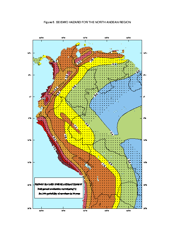
The final results are summarized in
the map of Figure 5 with peak ground acceleration curves in m/sec2
each 0.1 units. The values for peak ground acceleration for the
region run from about 6 m/sec2 at the Pacific coastal
region of Perú to 0.5 m/sec2 at the eastern
plains.
Figure 5. Peak ground acceleration for the North Andean region (m/sec2)
7. Discussion of Hazard Results
In general, the seismic hazard values
obtained in the PILOTO Project are comparable to those of the
probabilistic map of seismic hazard for South America (CERESIS,
1996), except for the high values obtained in the coast of Perú
and the low values at the coast of Chile. These differences are
probably due to different choices of subduction zones geometry
and assignation of the great historical subduction events to one
or another section in the subduction zones. It should be emphasized
the important amount of expert judgment involved in this type
of estimations due to incomplete knowledge of seismic sources
and processes.
As a final recommendation, something
to do in the near future is to establish a logic tree including
all uncertainties involved in seismic hazard assessment, to better
judge the influence of a given parameter in ground motion estimation.
8. References
CERESIS, Centro Regional de Sismología
para América del Sur (1985): Catálogo de Terremotos
para América del Sur. Ed. Askew, B., Algermissen, S. T.,
CERESIS, 4, 269 p.
CERESIS, Centro Regional de Sismología
para América del Sur (1996): 25 años: Convenio Multinacional,
30 años: Acuerdo Bilateral Perú-Unesco. p.8
CERESIS, Centro Regional de Sismología
para América del Sur (1996): Actualización del Catálogo
Sísmico Regional para América del Sur. Magnetic
copy.
de Mets, C., R. G. Gordon, D. F. Argus
and S. Stein (1990): Current plate motions. Geophys. Jour. Intl.,
101, 425-478.
Dorbath L., A. Cisternas and C. Dorbath
(1990): Quantitative assesment of great earthquakes in Peru.
Bull. Seismol. Soc. Am., 80, 551-576.
Freymueller, J., J. Kellogg and V. Vega
(1993): Plate motions in the North Andean Region. Jour. Geoph.
Res., V. 98, No. B12, pp. 21853-21863.
Tanner, J. G. and J. B. Shepherd (1997):
Seismic Hazard in Latin American and the Caribbean.. Instituto
Panamericano de Geografía e Historia, Final Report, Vol.
1,4.
Jordan, T. E., B. L. Isacks, R. W. Allmendinger,
J. A. Brewer, V. A. Ramos and C. L Ando (1983): Andean tectonics
related to geometry of subducted Nazca plate. Geol. Soc. Am. Bull.,
94, 341-361.
Gutenberg, B. and C. F. Richter (1956):
Earthquake magnitude, intensity, energy and acceleration. Bull.
Seismol. Soc. Am., 46, 131 p.
Maeda, K. (1996): The use of foreshocks
in probabilistic prediction along the Japan and Kuril Trenches.
Bull. Seismol. Soc. Am., 86, 1A, 242-254.
McGuire, R. (1993): Computations of
seismic hazard. Annali di Geofisica, Vol. XXXVI, N. 3-4. 181-200.
Norabuena, E. O., J. A. Snoke and D.
E. James (1994): Structure of the subducted Nazca plate beneath
Perú. Jour. Geoph. Res., 99, B5, 9215-9226.
Pennington, W. (1981): Subduction of
the Eastern Panama Basin and seismotectonics of Northwestern South
America. Jour. Geoph. Res., 86, B11, 10753-10770.
Piloto Project (1997): Piloto Project
for Regional Earthquake Monitoring and Seismic Hazard Assesment.
Final Report. Ed. Coordinator D. Giardini.
Quijada, P., E. Gajardo, M. Franke,
M. Kozuch, J. Grases (1993). Análisis de amenaza sísmica
de Venezuela para el nuevo mapa de zonificación con fines
de ingeniería. Memorias del Octavo Seminario Latinoamericano
de Ingeniería Sismo-resistente, July 1993, Mérida.
Risk Engineering (1996): FRISK88M Version
1.70 User's Manual.
Saragoni R., Crempian, M. Araya (1981):
Características de los movimientos fuertes en Chile. Publ.
SES I-2/81 (164).
Suárez, G., P. Molnar, B. Burchfiel
(1983): Seismicity, fault plane solutions, depth of faulting,
and active tectonics of Perú, Ecuador, and Southern Colombia.
Journ. Geoph. Res., 88, B12, 10403-10428.
Utsu, T. (1970): Aftershocks and earthquake
statistics (2) - further investigation of aftershocks and other
earthquake sequences based on a new clasification of earthquake
sequences, J. Fac. Sci. Hokkaido Univ. Ser. 7, 3,197-266. In Maeda,
K., 1996.
Figure 1
Events with magnitude equal or over 6.5 in the North Andean region,
extracted from CERESIS, 1996.
Figure 2
Events with magnitude less than 6.5 in the North Andean region,
extracted from CERESIS, 1996.
Figure 3a.
Ms vs. mb regression equations
for Argentina, Colombia, Bolivia and Ecuador. Thin lines correspond
to previous equations (CERESIS,1985), thick line to PILOTO equation.
Figure 3b.
. Ms vs. mb regression equations
for Chile and Peru. Thin lines correspond to previous equations
(CERESIS,1985), thick line to PILOTO equation.
Figure 4 Norht
Andean Region seismic sources
Figure 5.
Peak ground acceleration for the North Andean region (m/sec2).