S C Bhatia, M Ravi Kumar and H K Gupta
National Geophysical Research Institute, Hyderabad, India, Fax:+91-40-7171564,
E-mail: postmast @csngri.ren.nic.in
Abstract
This paper presents the results of an exercise carried out under GSHAP,
over India and adjoining regions bound by 0oN-40oN
and 65oE-100oE. A working catalogue of main shocks
was prepared by merging the local catalogues with the NOAA catalogue, and
removing duplicates, aftershocks and earthquakes without any magnitude.
Eighty six potential seismic source zones were delineated based on the
major tectonic features and seismicity trends. Using the probabilistic
hazard assessment approach of McGuire, adopted by GSHAP, the Peak Ground
Accelerations (PGA) were computed for 10 % probability of exceedence in
50 years, at locations defined by a grid of 0.5o X 0.5o.
Since no reliable estimates of attenuation values are available for the
Indian region, the attenuation relation of Joyner and Boore (1981) was
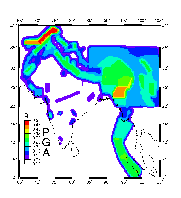
used. The PGA values over the grid points were contoured to obtain a seismic
hazard map. The hazard map depicts that a majority of the northern Indian
plate boundary region and the Tibetan Plateau region have hazard level
of the order of 0.25g with prominent highs of the order of 0.35-0.4g in
the seismically more active zones like the Burmese arc, Northeastern India
and Hindukush region. In the Indian Shield, the regional seismic hazard,
covering a major area, is of the order of 0.05-0.1g whereas some areas
like Koyna depict hazard to the level of 0.2g. The present map can be converted
in conventional seismic zoning map having four zones with zone factors
as 0.1g, 0.2g, 0.3g and 0.4g respectively.
Seismic hazard in the context of engineering design is generally defined as the predicted level of ground acceleration which would be exceeded with 10% probability at the site under consideration due to the occurrence of an earthquake anywhere in the region, in the next 50 years. GSHAP has adopted this definition of seismic hazard. A lot of complex scientific perception and analytical modelling is involved in seismic hazard estimation. A computational scheme involves the following steps: delineation of seismic source zones and their characterisation, selection of an appropriate ground motion attenuation relation and a predictive model of seismic hazard. Although these steps are region specific, certain standardisation of the approaches is highly essential so that reasonably comparable estimates of seismic hazard can be made worldwide, which are consistent across the regional boundaries. GSHAP has been coordinated at the global level and implemented at regional and local scales through a number of centers. Each center was concerned with a defined geographical territory to deal with the four main components of the seismic hazard assessment: preparation of unified/homogeneous earthquake catalogues, seismo-tectonic and earthquake source delineation, strong seismic ground motion studies and finally, computation of predictive seismic hazard. The National Geophysical Research Institute (NGRI), Hyderabad, India was identified as one such center, responsible for estimating the seismic hazard for the Indian region.
As it is well known, earthquake catalogues and data bases make the first essential input for the delineation of seismic source zones and their characterisation. Thus, preparation of a homogeneous catalogue for a region under consideration is an important task. As rightly recognized by the GSHAP, globally considering, the data from historic time to recent can broadly be divided in to three temporal categories: 1) since 1964, for which modern instrumentation based data are available 2) 1900-1963, the era of early instrumental data, and 3) pre 1900, consisting of pre-instrumental data, which is based primarily on historical and macro-seismic information. In India, the scenario is some what similar. The next key component of seismic hazard assessment is the creation of seismic source models, which demand translating seismo-tectonic information into a spatial approximation of earthquake localisation and temporal recurrence. For this purpose, all the available data on neo-tectonics, geodynamics, morphostructures etc., need to be compiled and viewed, overlain on a seismicity map. These maps then need to be critically studied for defining areal seismic source zones and active faults. An earthquake recurrence model is then fitted to these source zones, for defining the parameters that characterise the seismicity of the source region, which go as inputs to the algorithm for the computation of seismic hazard viz. Minimum and Maximum magnitudes and parameters 'a' and 'b' in the earthquake frequency magnitude relationship log N = a- bM. The third main element required for seismic hazard assessment is the designation of the strong ground motion (ground acceleration) estimation equations, specifying the ground acceleration as a function of earthquake magnitude and hypocentral distance. These equations have been developed for only a few regions of the world. Obtaining realistic estimates of strong ground motions in all regions is a major challenge that must be met.
The issue of seismic hazard in India has been addressed by scientists
as early as 1956 when a 3 zone (Severe, Moderate, Minor hazard) Seismic
Zoning map of India was produced ( Tandon, 1956). This map was based on
a broad concept of earthquake distribution and geotectonics. The severe
hazard zones are roughly confined to plate boundary regions i.e the Himalayan
Frontal Arc in the north, the Chaman fault region in the north west and
the Indo-Burma border region in the north east. The lower hazard zone is
confined to Indian shield region in the south and the moderate hazard zone
confined to the transitional zone in between the two. Since then, many
versions of the seismic zoning map of India have been brought out. The
Bureau of Indian Standards which is the official agency for publishing
seismic hazard maps and codes in India, produced a six zone map in 1962,
a seven zone map in 1966, and a five zone map in 1970 / 1984 which is currently
valid. The present five zone map is under review. Khattri et al. (1984)
adapting a probabilistic hazard computational approach published a map
of seismic hazard in units of g, for 10% probability of exceedence in
50 years.
2.0 Seismic source delineation
Seismic source delineation is primarily guided by tectonic trends and
seismicity. We have made a compilation tectonic features of the region
under study, based on "A Generalized tectonic map of India" by Khattri
et al. (1984), "Tectonic Map of the Himalayan Arc region" by Khattri (1987),
"Tectonic Map of India" published by Oil and natural Gas Commission, "Sketch
Map of major tectonic features of south east Asia" by Leloup et al. (1995),
the "Map of the Tibetan region" showing fault plane solutions of moderate
earthquakes and active faults (Molnar, 1992) and some unpublished material.
The compiled map is shown in Figure 1. The seismicity map of the
study region for earthquakes of magnitude 4 and above is shown is Figure
2a. Figure 2b shows the earthquakes of magnitude 6 and above, to highlight
regions which have experienced major earthquakes in the past. As can be
seen, seismicity of the Indian region is intense along its plate margins
and is rather diffused in other regions, except for some pockets like Koyna.
From seismotectonic considerations the Indian region can be sub divided
in to two major provinces 1) Himalayan arc and other plate boundary regions
and 2) the Indian Shield region. The broad tectonic and seismicity patterns
of these regions and the corresponding seismic source zones are described
below.
2.1 Himalayan arc and other plate boundary regions
The Indian plate boundary in the study region is characterised by a continental collision segment along the Himalaya in the north, a complex to an oblique subduction along the Burma-Andaman arc in the east and transverse fault systems such as the Chaman fault in the northwest . It is now well known that the continued northward collision of the Indian plate with respect to the Eurasian landmass causes the intense seismicity, and has produced the most gigantic topographic features of the world, the Himalaya and the Tibetan plateau. The 2400 km long east-west stretch of the Himalaya is composed of several north dipping thrust sheets which are also punctuated by topographic breaks. The major tectonic features in this region include, from south to north, the Main Boundary Thrust (MBT), the Main Central Thrust (MCT) and the Indus Tsangpo Suture Zone (ITSZ). All these linear tectonic features run all along the Himalayan belt from west to east having a NW-NS trend in the Northwestern Himalaya, E-W trend in the western, central and eastern Himalaya and NE-SW trends in the North eastern Himalaya. The Indus-Tsangpo suture zone is characterised by the ophiolite suite on the north and demarcates the northern limits of the Indian plate.
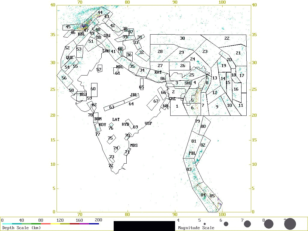
Most of the seismicity in the Himalayan region is concentrated along shallow north dipping planes, which indicate underthrusting of the Indian plate beneath the Eurasian plate. In addition to four great earthquakes of magnitude exceeding 8 during 1897, 1905, 1934 and 1950, another 10 earthquakes exceeding magnitude 7.5 have occurred in the Himalayan belt during the past 100 years. From a very simple consideration the whole Himalayan belt, from west to east, can be considered as one seismic source zone, but dividing the zone into smaller segments would be more appropriate. We have therefore segmented this region by source number 25 and 86 in the eastern sector , sources 34, 35 and 36 in the central sector, 40 and 41 in the western sector and 37, 38, 39, 42, 48, 49 and 50 in the northwestern sector.
In contrast to thrusting in the Himalaya, the extraordinarily thick crust of the Tibetan plateau in the north is characterised by crustal extension and eastward extrusion, manifested by earthquakes indicating normal faulting and strike-slip motion. The Altyn Tagh, the Kunlun and the Xianshuihe are the three major fault systems supporting the left-lateral strike-slip motion (Molnar, 1992). Sources 22,23, 24, 26, 27, 28, 29, 30,31, 32 and 33 have been delineated in this zone based primarily on seismicity trends (Figure 2a).
The Burma-Andaman arc marks the eastern margin of the Indian plate, along which an oblique convergence between the India and the Burmese plate has been suggested (Fitch, 1972; Curray et al., 1979). The major tectonic features along the arc are the N-S trending Indo-Burman ranges (IBR) in the north and the Andaman Nicobar ridge (ANR) in the south. The Sumatran fault system in the south-east, the Western Andaman fault (WAF) and the Sagaing fault further east, are the features supporting major right lateral movements in this region. The distribution of earthquakes in the Burmese arc region suggests the presence of a subducted Indian lithospheric slab beneath the Burmese plate (Verma et al., 1976; Mukhopadhyay and Das Gupta, 1988; Ni et al., 1989; Gupta et al., 1990). Occurrence of shallow and intermediate focus earthquakes has been reported in the Naga Hills (NH), and Arakan Yoma fold belt . While the seismic source zones 4, 5, 6, 7 and 8 cover the Burmese arc and adjoining region on the eastern side, the source zone 3 on the west encompasses the Shillong Plateau (SP) which experienced a strong earthquake of magnitude 8.7 in 1897. The tectonics of the Shillong plateau is distinctly different from that of the regions to its north south and west, and hence a separate zone for the region. The area further east namely the south China region is characterised by many faults and lineaments such as Red River Fault Zone (RRFZ). The seismic sources 9 through 23 have been identified in this seismic province.
The nature of convergence varies from a continental type in the Burmese arc to an oceanic type in the Andaman arc, with a relatively quiet seismic zone marking the transition (Chandra, 1984). Shallow and occasional intermediate-depth earthquakes delineate the subducted slab under the Andaman-Nicobar islands joining the seismicity trend of the Indo-Burman ranges. A distinct, separate lineation of shallow focus earthquakes passes under the Central basin of the Andaman sea and indistinctly follows the line of the Sagaing fault, towards the eastern Himalayan syntaxis (Curray, et al., 1979). The transition seismic zone referred above has been divided into sources 79 and 80. In the region south of this, along the Andaman Nicobar region sources 81, 82 and 83 have been assigned. Further south the sources 84 and 85 cover the north Sumatra region.
The northwestern Himalayan region also has the characteristic Himalayan
tectonic features namely the MBT, MCT and is bordered by the Hindukush
Syntaxis and the Pamir knot region in the extreme northwest. The Hindukush
and Pamir knot region are characterised by the junction of several tectonic
features. This plate boundary region experiences high level of seismicity
varying from shallow to intermediate-depth earthquakes. Sources 43, 44,
45, and 46 cover this region. The other prominent tectonic features in
the north western India region are the transverse fault systems known as
the Chaman fault, the Kirthar and Sulaiman ranges (SR). The tectonics of
the Kirthar-sulaiman ranges is influenced by transcurrent faulting. This
region also belongs to the plate boundary and experiences a high level
of seismicity. These areas are covered by sources 47, 51, 52, 53, 54 and
55.
2.2 Indian Shield region
The Indian shield region is marked by several rift zones and shear/thrust zones. Although considered to be a stable continental region (SCR) ,this region has experienced many earthquakes of magnitude M ò 6.0 since the 18th Century (Ramalingeswara Rao, 1998), some of which were disastrous. Among them are the Mahabaleshwar (1764), Kutch (1819), Damooh hill (Near Jabalpur, 1846), Mount Abu (1848), Coimbatore (1900), Son-Valley (1927), Satpura (1938), and Jabalpur earthquake of May, 1997. The spatial distribution of these high magnitude earthquakes is notable in Figure 2b. The seismicity in the shield region is quite diffused except for a few localised alignments, which are detailed below. Generally speaking, the Indian shield region can be considered as one single seismic source zone for hazard computations. However, smaller seismic zones can be delineated in this region, primarily based on the locales of the major earthquakes and seismic lineaments, some of which are not so well defined. The nature of seismicity, tectonic trends and the distribution of seismic sources is described below.
The Narmada-Son lineament (NSL) is a prominent tectonic feature of the Indian shield trending ENE-WSW from 21oN, 72oE on the western coast of India to 24oN, 88oE on the eastern side. This apparently divides the shield into 2 sectors , which we name as the northern and the southern sectors, to facilitate further description and discussions. The Narmada-Son region has been experiencing earthquakes of different magnitudes in the past, the recent example being the May 21, 1997 Jabalpur earthquake of magnitude 6.0. This is an SCR earthquake with an unusual focal depth of about 30 km. At least 4 earthquakes of magnitude >5.4 have earlier occurred along this zone, two of them in the proximity of the 1997 Jabalpur earthquake (Gupta et al., 1997b). We have assigned 2 probable seismic zones in the central part of the Narmada -Son lineament numbered 63 and 64. Further, while the north-east portion of the Indian shield is covered by sources 66, 67, 68, the region west of the Burmese arc and south of the Shillong plateau region is described by sources 1 and 2.
The major tectonic constituents in the southern sector of the Indian
Shield include the massive Deccan Volcanic Province (DVP), the South Indian
Granulite Terrain (SIGT), the Dharwar craton (DC), the Cuddapah basin (CB),
the Godavari graben (GG) and the Mahanadi graben (MG), the Eastern and
the Western ghats on the east and west coast of India, respectively.
The Eastern Ghat region in general is a quiet zone, charecterised by diffused low magnitude shallow focus earthquakes and an occasional earthquake of magnitude 5-6. The preferred fault plane solutions generally indicate north-east southwest orientation with left-lateral strike slip motion. Alternate set of solution indicates thrust faulting along northwest orientation. Not very many historical earthquakes are reported to have occurred in this region. Based on localised concentration of seismicity, we have delineated sources 70, 71 and 74 along the Eastern Ghat region.
The Western Ghat region of the Indian shield also depicts diffused seismicity, except for some clusters, the prominent one being the Koyna- Warna region. The Koyna reservoir region has been experiencing induced earthquakes right from the date of its first filling in 1962. Over the past 34 years the region around the reservoir has experienced 10 earthquakes of magnitude ³ 5, over 100 earthquakes of magnitude ³ 4 and about 100,000 of smaller magnitudes. The worlds largest reservoir induced earthquake of magnitude 6.3 occurred in the Koyna region on December 10, 1967. Warna reservoir located 20 km south of Koyna began to be filled in 1986. The Koyna-Warna region is experiencing a burst of seismicity since August 1993. More than a thousand earthquakes of magnitude around 2-3 have occurred since then. Two earthquakes of magnitude 5 and 5.4 occurred on December 8, 1993 and 1st February 1994 respectively. Gupta et al. (1997a) give a detailed picture of seismicity in the Koyna - Warna region. The seismicity in the region aligns itself beautifully along the local / regional fault systems. This Koyna -Warna region assumes a special relevance from seismic hazard point of view. This region therefore has been considered as a separate seismic souse zone numbered 77. The region along the western coast, north of Koyna has been considered as two sources, 78 and 62.
The source 78 around Bombay is characterised by N-S tectonic lineaments such as Panvel Flexure ( PF) and similarly aligned seismicity pattern. This source region is also reported to have experienced a large earthquake in the historic times. The source 62 encompasses the NW-SW trending features in the Cambay basin and the western end of W-E trending Narmada son lineament also depicts reasonable level of seismicity to merit designation of an independent seismic source. Down south, near Trivandrum along the western margin we have delineated source 72 primarily on account of some recent concentration of seismic activity .
In the central shield region south of the Narmada Son lineament the seismic activity is considerable, although diffused. The Latur region in central India experienced an earthquake of Mw 6.1 in 1993. The inferred depth was about 5 km and the focal mechanism by several agencies indicated a thrust type faulting with the P axis trending NNE, consistent with the direction of the India-Eurasia plate motion. The inferred fault plane was NW striking and dipping 45 degrees SW. Seeber et al. (1996) suggested that the earthquake was caused by a new fault in the Deccan trap region. On the other hand, Rajendran et al. (1996) inferred the trend of a pre-existing fault based on a study of Landsat images prior to the earthquake. On the basis of borehole studies across the fault, which indicate large displacement of 3 to 6 meters, Gupta et al. (1998) suggested that the displacement is far too much to be accounted by a single earthquake of Mw 6.1 and concluded that the fault is a pre-existing one. It appears that this region has also been active in the historical times. In view of these considerations the region around Latur has been taken as a seismic source zone numbered 76. The source 69 covers the Godavari Graben region which experienced a moderate sized earthquake of Mag 5.3 , known as Bhadrachalam earthquake, in the year (1969 ). The region around Bellary and Cambatore have been demarcated as source zones 75 and 73 respectively on account of having experienced moderate sized earthquakes in the past as referred in the earlier section.
The northern sector of Indian shield has a relatively lower level of seismicity. The region has a prominent tectonic feature called the Bundelkhand Craton ( BC) in the central area bounded by NNE -SSW to N-S trending lineaments on the west as well as on the east. Sources 57, 60, 61 and 65 are delineated in this region.
The northwestern corner of Indian shield (in the vicinity of 24oN
and 72oE ) is characterised by N-S, NW-SE and E-W tectonic trends
and show relatively higher level of seismicity. Sources 56, 58 and 59 have
been identified in this region. The source zone 59 experienced the well
known 7.8 magnitude Kutch earthquake of 1819.
3.0 Source zone characterisation
The GSHAP exercise for India region started with the exercises in the GSHAP Test Area #8 covering parts of India, China, and Nepal, bounded by 20oN- 40oN and 85oE-105oE during the workshop held at NGRI in February-march 1996. As stated earlier, the seismicity and tectonic patterns make the bases for delineation of the seismic source zones for the seismic hazard computations. Towards the preparation of an earthquake catalogue for source zonation, the NOAA catalogue and local catalogues were considered. To start with the test area was divided into 16 source zones and on the basis of the seismicity patterns emerging from a plot of epicenters in the region in conjunction with the tectonic information. Later, further exercises were done with 30 source zones and 56 source zones. After a critical examination of the seismicity and tectonic constraints along with the computed PGA values, it was felt that the 30 source zone model is best suited for the region (Bhatia et al, 1997). In continuation of the test area exercise, the region bounded by 0-40oN and 65-100oE was considered for attempting preparation of a seismic hazard map of India and adjoining regions. Again, based on the seismicity distribution and tectonic trends, 86 potential seismic source zones were delineated. Figures 2 (a) and (b) show these seismic source zones. Of these 86 zones, 30 zones belong to the GSHAP test area #8 (India - China- Nepal) which extends eastwards to 105oE . A working catalogue of main shocks was prepared by removing duplicates, aftershocks and earthquakes without any magnitude.
The minimum magnitude was assigned as 5.0 for all the source zones because it is the lower level of magnitude which would cause hazard of a significant level. The maximum magnitude was estimated from the past seismicity for each of the zones separately. The seismic parameters 'a' and 'b' were estimated by applying the maximum likelihood method and converted to Nu and Beta, which go as inputs to the hazard computations.
The source zones corresponding to the seismically active regions in the plate plate boundary and adjacent regions contain enough earthquakes for an independent statistical computation of a and b values. However, the source zones in the Indian shield, do not contain sufficient information for this purpose. To overcome this problem, the b value was computed for the whole shield region as one unit and was assigned to each zone within it, while the a value was computed for each zone separately. A similar philosophy was adopted for a few other source zones with sparse seismicity. The details of the characteristics of each source zone are listed in Table 1.
To facilitate the steps for source zone characterisation, a software
toolbox was developed at NGRI. This software package performs the essential
data handling and pre-processing tasks like (1) scanning of Earthquake
catalogues (of different formats) to segregate events for the specified
rectangular block defined by latitude-longitude limits, or a polygonal
block defined by latitudes and longitudes of the vertices, (2) merging
different catalogues and sorting in chronological order (3) removal of
the duplicates (4) removal of aftershocks according to a defined criteria
and preparation of main-shock catalogue, (5) plotting of epicenters by
superposing the source zones and tectonic features, geographical locations
etc. (6) estimation of a and b values as well as (7) extracting required
information from the output files of FRRISK88M, for preparation of hazard
maps.
4.0 The seismic hazard map
Using the probabilistic hazard assessment approach of McGuire adopted
by GSHAP, the Peak Ground Accelerations (PGA) were computed using the FRISK88M
software for 10 % probability of exceedence in 50 years, at locations defined
by a grid of 0.5o X 0.5o in the region 0oN-40oN
and 65oE -100oE. Since no reliable estimates of attenuation
values are available for the Indian region, the attenuation relation of
Joyner and Boore (1981) was used. The PGA values over the grid were contoured
to obtain a seismic hazard map (Figure 3). A contour interval of 0.05g
was chosen, since we believe that problems and uncertainties associated
with the source zone definition and paucity of the seismicity information
would not permit resolution better than 0.05g. The hazard map depicts that
a majority of the plate boundary region and the Tibetan plateau region
have hazard levels of the order of 0.25g with prominent highs of the order
of 0.35-0.4g in the seismically active zones like the Burmese arc, Northeastern
India and North-west Himalaya / Hindukush region. In the Indian Shield
region, the regional seismic hazard is mostly of the order of 0.1g whereas
some areas like Koyna depict hazard to the level of 0.2g.
Concluding remarks
The computational experience in the GSHAP exercises have brought out
certain concerns. The major concerns that have emerged are that the Indian
region poses a lot of problems for the data homogenisation efforts and
seismic hazard maps are strongly influenced by the size and shape of seismic
source zones. Another key issue which is a cause of concern is non availability
of representative strong motion attenuation formulae which compelled us
to be satisfied with applying one of the internationally developed formulae.
The seismic hazard map of India and adjoining regions presented here is
one possible map with all constraints outlined. This map, we believe gives
a reasonably representative seismic hazard picture over the region covered.
This map can be well adopted to produce a 4 zone Seismic Zoning map of
the region:
Zone Region covered Zone factor
by contours
Zone I : up to 0.1g 0.1g
Zone II : > 0.1g to 0.2 g 0.2g
Zone III : > 0.2g to 0.3 g 0.3g
Zone IV : > 0.3g to 0.4 g 0.4g
We have carried out computations considering the probable source zone
depth as 10 km. Any depth shallower than this would be unrealistic since
large earthquakes do not take place at very shallow depths. Any depth deeper
than 10 km would also not have much meaning because it would reduce the
hazard considerably and one needs to take a conservative but realistic
approach. The hazard values in the map presented here are lower than the
ones given by Khattri et al. (1984 ). We would get same level of hazard
if the source depth was put at 0 km. Apparently Khattri et al (1984) took
source depth of zero km, which produced higher values of hazard estimates.
Acknowledgments
The authors are thankful to Dr. Puranchandra Rao for his help in compiling
the tectonic map and to Dr. B R Rao for providing his unpublished catalogue
of the Indian shield region. The help rendered by Mrs. M Murli Kumari at
all the stages of data preparation, data processing and report preparation
is thankfully acknowledged. Sincere thanks are expressed to Dr. Peizhen
Zhang for discussions and collaborative work in the test area.
References
Bhatia S C , H.K. Gupta, M. Ravi Kumar, N.P. Rao, G.R. Chitrakar, P. Zhang and Z-X Yang, 1997. Seismic hazard map of GSHAP Area XII comprising eastern Himalaya, Northeastern India, Burmese arc, South China and adjoining regions, Abstract, 29th General assembly of IASPEI, August 18-28, 1997, Thessaloniki, Greece, p387.
Chandra, 1984. Tectonic segmentation of the Burmese-Indonesian arc. Tectonophysics, 105, 279-290.
Curray, J.R., Emmel, F.J., Moore, D.G., Raitt, R.W., Henry, M., and Kieckhefer, R., 1979. Tectonics of the Andaman sea and Burma, In: J.S. Watkins, L. Montadert and P. Dickerson (Editors), Geological and Geophysical Investigations of Continental margins. AAPG Memoir, 29, 189-198.
Fitch, T.J., 1972. Plate convergence , transcurrent faults and internal deformation adjacent to SE Asia and western Pacific. J. Geophys. Res., 77,4432-4460.
Gupta, H.K, Rastogi, B.K and Narain, H, 1972a. Common features of the reservoir associated seismic activities. Bull. Seismol. Soc. Am., 62, 481-492.
Gupta, H.K, Rastogi, B.K and Narain, H, 1972b. Some discriminatory characteristics of earthquakes near Kariba, Kremasta and Koyna artificial lakes, Bull. Seismol. Soc. Am., 62, 493-507.
Gupta, H.K., Fleitout, L., and Froidevaux, C., 1990. Lithospheric subduction beneath the Arakan Yoma fold belt : Quantitative estimates using gravimetric and seism ic data, J. Geol. Soc. India, 35, 235-250.
Gupta, H.K, K.N. Kanal, S.K. Upadhyay, D. Sarkar, B.K. Rastogi and S.J. Duda, 1995. Verification of magnitudes of Himalayan region earthquakes 0f 1903-1985 from Goettingen observatory, Tectonophysics, 244, 267-284.
Gupta, H.K, B.K. Rastogi, R.K. Chadha, P. Mandal and C.S.P. Sarma, 1997a. Enhanced reservoir induced earthquakes in Koyna region, India, during 1993-95. Jour. Seismol., 1, 47-53.
Gupta, H.K, R.K. Chadha, M.N. Rao, B.L. Narayana, P. Mandal, M. Ravi Kumar and N. Kumar, 1997b. The Jabalpur earthquake of May 22, 1997. Jour. Geol. Soc. India, 50, 85-91.
Gupta, H.K, K.K. Dwivedi, D.C. Banerji, R.U.M. Rao, G.V. Rao and R. Srinivasan, 1998. Latur earthquake, Maharashtra India: A case study of a borehole investigation at SCR earthquake site, Abstract, Chapman conference on Stable Continental Region earthquakes, January 25-29, 1998, NGRI, Hyderabad, India, p.39.
Joyner , W. B. and Boore, D. M.,1981. Peak acceeleration and velocity from strong-motion records including records from the 1979 Imperial Valley , California, Earthquake, Bull. Seismol. Soc. Am.,71,2011-2038.
Khattri, K.N., Rogers, A.M., Perkins, D.M. and Algermissen, S.T., 1984. A seismic hazard map of India and adjacent areas. Tectonophysics, 108: 93-134.
Khattri, K.N., 1987. Great earthquakes, seismicity gaps and potential for earthquake disaster along the Himalaya plate boundary. In: K. Mogi and K.N. Khattri (Editors), Earthquake Prediction, Tectonophysics, 138, 79-92.
Leloup, P.H, Lacassin, R., Tapponier, P., Schaerer, U., Dalai, Z., Xiaohan, L., Lianshang, Z., Shaocheng, J., Trong and Trinh, P.T., 1995. The Ailao Shan - Red River shear zone (Yunnan, China), Tertiary transform boundary of Indochina, Tectonophysics, 251, 3-84.
Molnar, P., 1992. A review of seismicity, recent faulting and active deformation of the Tibetan plateau. J. Him. Geol. 3,43-78.
Molnar, P., Fitch, T.S., Wu F.T., 1973. Fault plane solutions of shallow earthquakes and contemporary tectonics in Asia. Earth Planet. Sci. Lett., 19: 101-112.
Mukhopadhyay, M., and Das Gupta, S., 1988. Deep structure and tectonics of the Burmese arc : constraints from earthquake and gravity data. Tectonophysics, 149, 299-322.
Ni, J.F., Speziale, M.G., Bevis, M., Holt, W.E., Wallace, T.C. and Seager, W.R., 1989. Accretionary tectonics of Burma and the three dimensional geometry of the Burma subduction. Geology, 17, 68-71.
Rajendran, C.P, K. Rajendran and B. John, 1996. The 1993 Killari (Latur) central India earthquake: An example of fault reactivation in Precambrian crust, Geology, 24, 7, 651-654.
Ramalingeswara Rao, B., 1998. A catalog of Indian shield earthquakes. Personal Communication.
Seeber, L, G. Ekstrom, S.K. Jain, C.V.R. Murthy, N. Chandak and J.G. Ambruster, 1996. The Killari earthquake in central India: A new fault in Mesozoic basalt flows?, Jour. Geophys. Res., 101, B4, 8543-8560.
Tandon, A.N., 1956. Zones of India liable to earthquake damage. Ind. J. Meteorol. Geophys., 10:137-146.
Verma, R.K., Mukhopadhyay, M. and Ahluvalia, M.S., 1976. Earthquake
mechanisms and tectonic features of northern Burma. Tectonophysics, 32:
387-399.
FIGURE CAPTIONS
Figure 2(a) : Seismicity and source zones map of India and adjoning region. Dots are the epicenters of earthquakes of Mag. 4 and above. Blocks numbered 1 through 86 are the source zones . Some cities are shown for orientation purpose: BMB (Bombay), BUJ(Bhuj), CAL (Calcutta), HYD (Hyderabad), JBL (Jabalpur), KAT (Kathmandu), KBL (Kabul), KOY (Koyna), LAH(Lahor),LAT (Latur), MDS (Madras), NDL (New Delhi), PBL: Port Blair, QUE (Quetta), SHL (Shillong), SRI (SriNagar), VSP(Vishakhapatnam)
Figure 3 : Seismic hazard map of India and adjoining
regions for 10% probability of exceedance in 50 years. Contour interval
0.05g.
| Source
No. |
Max.
Mag. |
Nu
(mag.5.0) |
Beta | Source No. | Max.
Mag. |
Nu
(mag.5.0) |
Beta |
| 1 | 6.5 | 0.016 | 1.379 | 44 | 8.0 | 3.385 | 1.610 |
| 2 | 8.5 | 0.378 | 1.194 | 45 | 8.5 | 1.434 | 1.549 |
| 3 | 8.7 | 0.422 | 1.449 | 46 | 7.5 | 0.042 | 1.549 |
| 4 | 8.5 | 0.566 | 1.134 | 47 | 7.5 | 0.689 | 1.617 |
| 5 | 8.5 | 1.712 | 1.134 | 48 | 7.0 | 0.150 | 1.649 |
| 6 | 8.0 | 0.482 | 1.570 | 49 | 7.5 | 0.089 | 1.671 |
| 7 | 8.0 | 0.201 | 1.130 | 50 | 7.0 | 0.104 | 1.671 |
| 8 | 8.0 | 0.591 | 1.340 | 51 | 7.0 | 0.151 | 1.919 |
| 9 | 7.0 | 0.416 | 1.008 | 52 | 8.0 | 0.205 | 1.771 |
| 10 | 7.0 | 0.602 | 1.068 | 53 | 7.0 | 0.079 | 1.634 |
| 11 | 7.0 | 0.172 | 1.263 | 54 | 7.5 | 0.349 | 1.668 |
| 12 | 7.5 | 0.243 | 1.062 | 55 | 7.5 | 0.154 | 1.634 |
| 13 | 6.5 | 0.352 | 1.139 | 56 | 7.0 | 0.074 | 1.795 |
| 14 | 7.5 | 0.410 | 1.445 | 57 | 7.0 | 0.001 | 1.379 |
| 15 | 7.5 | 0.287 | 1.268 | 58 | 7.5 | 0.011 | 1.266 |
| 16 | 8.5 | 0.353 | 1.071 | 59 | 8.5 | 0.126 | 1.266 |
| 17 | 7.0 | 0.383 | 1.278 | 60 | 6.5 | 0.034 | 1.379 |
| 18 | 7.5 | 0.192 | 1.387 | 61 | 7.5 | 0.026 | 1.379 |
| 19 | 7.5 | 0.221 | 1.219 | 62 | 6.5 | 0.049 | 1.379 |
| 20 | 8.0 | 0.285 | 1.219 | 63 | 6.5 | 0.034 | 1.379 |
| 21 | 7.5 | 0.487 | 1.292 | 64 | 6.5 | 0.022 | 1.379 |
| 22 | 8.0 | 0.199 | 1.421 | 65 | 6.0 | 0.008 | 1.379 |
| 23 | 7.0 | 0.422 | 1.432 | 66 | 6.5 | 0.001 | 1.379 |
| 24 | 8.5 | 0.704 | 1.253 | 67 | 6.0 | 0.039 | 1.379 |
| 25 | 8.5 | 0.864 | 1.073 | 68 | 6.5 | 0.028 | 1.379 |
| 26 | 8.0 | 0.270 | 0.979 | 69 | 6.5 | 0.033 | 1.379 |
| 27 | 8.5 | 0.133 | 1.495 | 70 | 6.0 | 0.050 | 1.379 |
| 28 | 8.0 | 0.494 | 1.362 | 71 | 6.0 | 0.006 | 1.379 |
| 29 | 8.0 | 0.426 | 0.997 | 72 | 6.0 | 0.008 | 1.379 |
| 30 | 7.0 | 0.739 | 1.308 | 73 | 6.0 | 0.016 | 1.379 |
| 31 | 6.5 | 0.247 | 1.394 | 74 | 6.0 | 0.001 | 1.379 |
| 32 | 7.0 | 0.164 | 1.394 | 75 | 6.0 | 0.006 | 1.379 |
| 33 | 7.0 | 0.077 | 1.394 | 76 | 6.5 | 0.003 | 1.379 |
| 34 | 8.0 | 0.171 | 1.230 | 77 | 6.5 | 0.128 | 1.379 |
| 35 | 8.0 | 0.631 | 1.406 | 78 | 6.5 | 0.128 | 1.379 |
| 36 | 7.5 | 0.086 | 1.406 | 79 | 6.5 | 0.148 | 1.378 |
| 37 | 7.0 | 0.143 | 1.634 | 80 | 7.5 | 0.139 | 1.378 |
| 38 | 7.0 | 0.030 | 1.634 | 81 | 8.5 | 0.694 | 1.434 |
| 39 | 7.0 | 0.174 | 1.764 | 82 | 7.0 | 0.677 | 1.367 |
| 40 | 7.5 | 0.155 | 1.193 | 83 | 7.5 | 1.809 | 1.361 |
| 41 | 8.5 | 0.405 | 1.388 | 84 | 7.5 | 1.676 | 1.440 |
| 42 | 7.5 | 0.298 | 1.323 | 85 | 7.5 | 1.259 | 1.409 |
| 43 | 7.5 | 0.069 | 2.131 | 86 | 8.5 | 0.395 | 1.495 |
Table 1: The characteristics of the seismic source zones.