![]()
SEISMIC HAZARD ASSESSMENT IN
EASTERN AND SOUTHERN AFRICA
Vunganai Midzi1
, Dumisani J. Hlatywayo2 , Lostina S. Chapola3
, Fekadu Kebede4, Kuvvet Atakan5, Daniel
K. Lombe6 , Gadi Turyomurugyendo7,
Fred Alex Tugume7.
SUMMARY
Seismic hazard assessment
for the eastern and southern Africa region was done using the probabilistic
approach. Seismic hazard maps for 10% exceedence in 50 years, 10% exceedence
in 100 years, as well as for 50 and 100 years return periods were prepared
using the FRISK88M software. The area involved covers a wide region bounded
by latitudes 40°S - 25°N and longitudes 10°E and 55°E.
Input parameters for the computations were obtained using the recent earthquake
catalogue compiled by Turyomurugyendo. The catalogue which covers the time
period 627-1994, contains earthquakes within the area bounded by 40oS-25oN
and 10oE-55oE, with homogeneous magnitudes (MS).
Since a Poisson model of earthquake occurrence is assumed, dependent events
were cleaned from the catalogue. Attenuation relations for the Eastern
and Southern Africa region based on the strong motion data are virtually
non-existent. However, attempts have been made recently by Jonathan and
Twesigomwe to establish an average attenuation relation for the region.
These relations were used in the computations. Possible uncertainties in
the attenuation relations were accounted for using the logic-tree formalism.
The results are presented in seismic hazard maps in terms of peak ground
acceleration (PGA) for the mean and the 85th percentile. The distribution
of PGA values indicate relatively high hazard along the East African Rift
system. In the northern segments of the rift system, they exceed 250 gals
for 10% probability of exceedence in 50 years.
INTRODUCTION
Eastern and Southern Africa
covers a region which is prone to a significant level of seismic hazard
due to the presence of the East African rift system. A number of destructive
earthquakes, some causing loss to life, have been reported during this
century. For example, in Eritrea, the port city of Massawa was destroyed
by an earthquake which occurred in 1921. In Ethiopia, they include the
1960 Awasa earthquake (MS = 6.1), the 1961 Kara Kore earthquake
which completely destroyed the town of Majete and severely damaged Kara
Kore town, the 1969 Serdo earthquake (MS = 6.3) in which four
people were killed and 24 injured, 1989 Dobi graben earthquake (MS
= 6.5) which destroyed several bridges on the highway connecting the port
of Assab to Addis Ababa, the 1983 Wondo Genet and the 1985 Langano earthquakes
which caused damage in parts of the main Ethiopian rift. In Uganda, damaging
earthquakes include the 18 March 1945 Masaka event (MS = 6.0)
in which five people were killed, the Tooro event of 20 March 1966 (MS
= 6.1) in which 160 people were killed, 1300 people injured and 7000 buildings
were destroyed or damaged, and the Kismoro earthquake of 5 February 1994
(MS = 6.0), which killed eight people. In Malawi, the Salima
earthquake (MS = 6.1) of 10 March 1989 killed nine people. Other
damaging earthquakes have been reported in Tanzania which includes the
Kasanga earthquake (MS = 7.3) of 13 December 1910, which caused
significant damage in southern Tanzania. Realising this major threat in
the region, which covers an area of approximately 5.5 million square kilometres
with more than 120 million people, the region's capacity in earthquake
preparedness and hazard mitigation needs to be improved significantly.
The prerequisite in any hazard mitigation program is to investigate the
earthquake hazard potential in the region through an assessment of seismic
hazard using state-of-the-art techniques. In this report, probabilistic
earthquake hazard analysis is performed for the region using the latest
available computer software provided by the Risk Engineering (1996), within
the framework of the Global Seismic Hazard Assessment Program (GSHAP).
The results are presented in terms of seismic hazard maps showing the peak
ground acceleration (PGA) levels covering the region for 10% probability
of exceedence in 50 years, 10% exceedence in 100 years, as well as 50 and
100 years return periods.
In recent years, there has been increasing co-operation in seismology among nine countries in the eastern and southern Africa region. These are Eritrea, Ethiopia, Uganda, Kenya, Tanzania, Malawi, Zambia, Zimbabwe and South Africa. This co-operation has lead to the establishment of the Eastern and Southern Africa Regional Seismology Working Group (ESARSWG), which is now a recognised component of the Committee for Developing Countries under the International Association of Seismology and Physics of the Earth's Interior (IASPEI). One of the major tasks of the ESARSWG is to improve the understanding of seismic activity and assess the seismic hazard potential of the eastern and southern Africa region. Since the establishment of EASRSWG, three workshops have been held specifically on seismic hazard assessment. The first preparatory meeting was held in Kampala, Uganda in 1994. The second workshop was in Addis Ababa, Ethiopia in 1995. The first preliminary probabilistic seismic hazard map for the region was prepared there. The third workshop was held in Bulawayo, Zimbabwe in 1996. At this workshop, significant improvements were made to the Addis Ababa hazard maps. Seismic source zone delineation was improved and different computational procedures tested. We present in this paper, results from the fourth workshop on hazard assessment in the eastern and southern Africa region. The work reported here is built upon the experiences gained from the previous three workshops and data compiled then.
TECTONICS
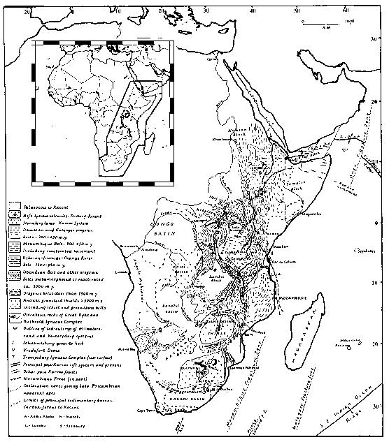
Major tectonic features in
the eastern and southern African region is mainly controlled by the well-known
geological structure, the East African rift system. This feature extends
as a continuous structure for approximately 4000 km from the triple junction
in the Afar region joining the full spreading ridges in the Red-Sea and
the Gulf of Aden in the north, to the less mature continental rifting that
basically follows the mobile belts in the south (Fig.
1). The age of the rifting varies from Tertiary to Recent; in some
places rifting related to Karoo volcanic activity dates back to Permo-Triassic
or Early Jurassic (King, 1970). In many places the structures within
the rift have been influenced by the pre-existing Precambrian zones of
weakness. Morphology of the rift resembles that of the mid-oceanic ridges
with central rift valleys acting as depositional basins.
The rift basins are asymmetric and are bordered by curvilinear high angle border fault segments on one side and en echelon step faults with minor vertical offsets and flexural monoclines on the opposite side (Bosworth et al., 1986; Rosendahl, 1987; Ebinger,1989; Dunkelman et al., 1989; Chapola, 1997). Well developed grabens are only found in the Gregory and Ethiopian rifts, while the rest of the rift is characterised by alternate half-grabens (Baker et al., 1972). Individual half-grabens are separated from each other by accommodation zones which are complex structural highs made up of oblique-slip transfer faults, ramps and monoclines (Chapola, 1997). The accommodation zones act as transfer zones that allow switches in gross polarity of the border fault systems.
![]()
Figure 1. The rift
system of eastern and southern Africa in its geological setting (modified
after McConnell, 1972). The inset shows the map of Africa with national
boundaries. The bold outline of the inset marks the boundary of the area
for which seismic hazard was computed.
South of Ethiopia, the East
Africa rift system breaks up into two branches, the Western rift and the
Eastern rift. Continental rifting starts from the Afar triple junction
and continues towards the south through the Ethiopian rift, joining into
the Gregory rift in Kenya. This structure constitutes the eastern branch
of the East Africa rift system. Further south, it branches into the Davie
Ridge (Mougenot et al., 1986). The northern sector of this rift segment
cuts across the abyssal plateau volcanics of Kenya. In eastern Tanzania,
the rift structures form a broad zone of faults defining a series of tilted
blocks with varying orientations. Southeast of mount Kilimanjaro, the Pare-Usambara
faults define a branch of the eastern rift which trends SE to join the
fault systems of the Davie Ridge in the Indian Ocean.
The western branch of the
East Africa rift system extends from northern Uganda to southern Mozambique,
encompassing the major lakes in the region such as the lakes Albert, Edward,
Tanganyika and Malawi. Its northern boundary terminates abruptly in the
Precambrian Aswa shear zone, a structure which stretches NW-SE from southern
Sudan through Uganda into Kenya. In the north, the rift is characterised
by a N-S oriented zone that follows the earlier structural trends through
the en echelon faults of the Albert Nile, lakes Albert, Edward, Kivu and
Ruwenzori mountains. The E-W trending Katonga fault zone extends
from north of lake Victoria towards the western rift. South of lake Kivu
the fault orientations change from NNE-SSW to NNW-SSE. Major structures
in this area are the border fault systems of lake Tanganyika and Rukwa
that joins into the faults bordering Lake Malawi.
In the south, the main features
of the rift in the Malawi-Mozambique segment are border faults defining
Lake Malawi. The southern extension of the lake Malawi rift is defined
by faults bounding the Shire trough which extends to Urema trough and the
Lebombo monoclinal structure in southern Mozambique.
SEISMICITY
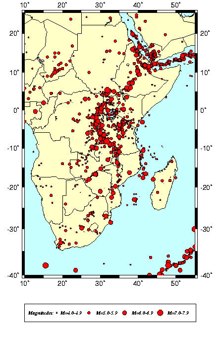
Earthquake activity in the eastern and southern Africa region is characterised by the occurrence of destructive earthquakes which are controlled by the well-known regional tectonic feature, the East Africa rift system. Figure 2 shows the distribution of earthquake epicentres in the region for the period 627-1994, for MS magnitudes larger than 4.0. Activity is highest along the two spreading axes in the Red-Sea and the Gulf of Aden, which joins into the main Ethiopian Rift through the Afar triple-junction. Further to the south along the eastern branch, epicentre distribution is more diffuse than along the western branch where a concentration of epicentres follows the rift structures starting from southern Sudan to southern Malawi.
![]()
Figure 2. Seismicity
of eastern and southern Africa based on the catalogue compiled by Turyomurugyendo
(1996). Earthquake epicentres are shown for MS4.0.
Activity continues to the
south along the extension of the rift in Mozambique. Two branches from
the western rift follow geological structures along belts in southern Democratic
Republic of the Congo into western Zambia and along the Deka fault, mid-Zambezi
valley and Luangwa rift. Activity in the eastern branch extends in to a
broad zone in Tanzania and continues along the Davie Ridge in the Indian
Ocean. South of Zimbabwe, seismicity is generally sparse with epicentres
concentrated along the eastern half and central northern Transvaal in South
Africa. East-West oriented concentration of epicentres are observed in
the southern tip of Africa around Cape Town while further to the south-east,
the plate boundary-related seismicity appears as a NE-SW alignment of epicentres.
On the other hand, the NE-SW oriented epicentre alignment around the co-ordinates
10o N and 20o E is probably due to mislocations (pers.comm.,
R. Adams, 1995). The hypocentral depths are generally in the range 10-20
km. Recent results however, indicate that deep earthquakes (depths in excess
of 30 km) have occurred in some segments of the rift (Jackson and Blenkinsop,
1993; Camelbeeck and Iranga, 1996; Nyblade et al., 1996). These have confirmed
earlier reports from micro-earthquake studies by Maasha (1975), Bungum
and Nnko (1984).
INPUT DATA
Probabilistic seismic hazard
analysis, requires the use of all available earthquake data, i.e. both
historical as well as instrumental, for a region. In this compilation,
data prepared during previous studies in the region were used as primary
data. A special emphasis was given to contributions to data from the region.
The input data used in the computations that follow are described in three
sections, namely: (i) earthquake catalogue, (ii) seismic source zonation
and (iii) attenuation relations. Parameters used for the individual source
zones are also discussed separately.
Earthquake catalogue
The earthquake data used
in this study is derived from the Earthquake Database for Eastern and Southern
Africa (Turyomurugyendo, 1996). The data, compiled from a number of sources,
covers the period 627-1994 and is for an area bounded by latitudes, 40o
S and 25o N and longitudes, 10o E-55 E. In his work,
Turyomurgyendo found that for some events, different hypocentral and parametric
solutions were given by different reporting agencies. In order to get the
best solution, priority was given to the different agencies with emphasis
on the individual specific studies from publications where the source parameters
had been re-worked and improved upon. Table 1 shows the priority list of
the different agencies adopted in preparing the catalogue for the period
627-1963. For the period 1964-1994, the priority solutions were kept as
reported by International Seismological Centre.
All magnitudes were homogenised
to MS and dependent events (foreshocks, aftershocks, induced
events) were removed using the formulae suggested by Lazarov and Christoskov
(1981). Catalogue completeness was carefully studied and the period
1900-1994 was found complete for magnitudes larger than 5.0.
Table 1. Source priority
list adopted in data compilation
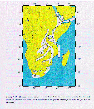
Seismic source zonation
In seismic source zoning,
a thorough analysis of the main tectonic structures and their correlation
with present-day seismicity was the basis for the delineation of the source
zones. The present study covers a large area of approximately 50o
x 25o. At such a large scale, only regional structures could
be accounted for in preparing the source zones. The detailed structures
and the individual faults were treated as broad fault zones that comprised
area sources. Twenty-one area source zones were defined along the major
rift segments (Fig. 3). One possible way of
improving the source zonation, especially for the site-specific studies,
is the inclusion of fault sources to the area sources. This requires a
detailed knowledge of the exact location and the extent of the individual
faults or fault zones and the earthquake recurrence relations. Individual
fault study and mapping was not carried out to enable this parameter to
be input in the hazard computations in this study.
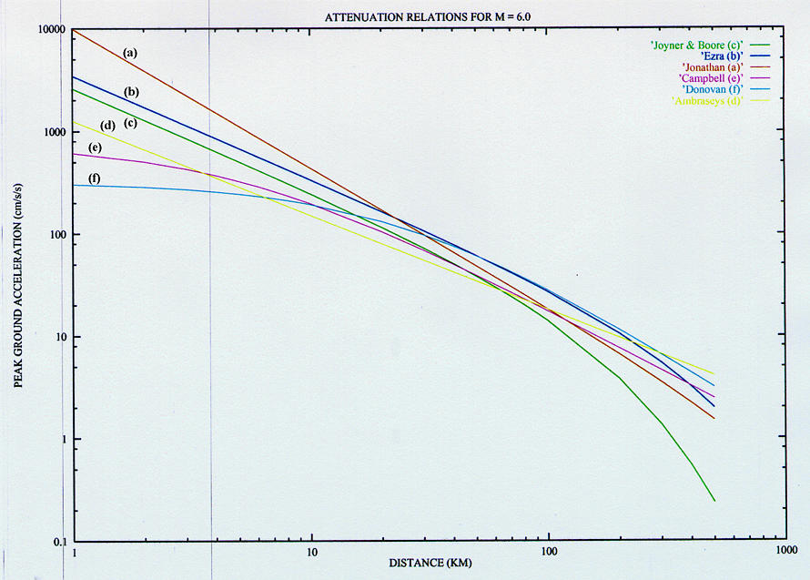
Attenuation
Attenuation relations for
the eastern and southern Africa region based on the strong motion data
are virtually non-existent. However, attempts have been made recently by
Jonathan (1996) and Twesigomwe (1997) to establish average attenuation
relations for the region. Jonathan's relation is based on the random vibration
theory using some recent earthquakes recorded by the digital stations in
the region. Twesigomwe's relation, on the other hand, is a modification
of the previously established relation by Krinitzky et al. (1988) using
regional shear-wave velocity and Q values determined by other workers like
Gumper and Pomeroy (1970).
![]()
Figure 3. The 21 seismic
source zones used in the study. Note that zones cover basically the seismically
active rift segments and areas where seismotectonic background knowledge
is sufficient (see text for discussion).
These two relations are derived
with data from the region under consideration in this study. The two relations
are given here below:
lna = 3.024 + 1.030MW -1.351 lnR - 0.0008R (Jonathatn, 1996)
lna = 2.832 + 0.866MS - lnR - 0.0025R + epsilon (Twesigomwe, 1997)
where, a is
the ground acceleration (cm/sec2), R is the hypocentral
distance (km) and epsilon is the error term.
An attempt was made to compare the two attenuation curves given above with the Joyner and Boore (1982, 1988), Boore et al., (1993, 1994) relations. These relations are shown in Fig. 4. The figure shows that there is a close agreement between the regional attenuation relation curves and those widely used globally. For the hazard computations in this study, attenuation relations developed by Jonathan (1996) and Twesigomwe (1997) were adopted. A standard deviation of 0.6 for both relations was applied. Both relations were developed for hard rock conditions.
![]()
Figure 4. The attenuation
relations used in the seismic hazard computations shown together with some
other known relations for comparison.
Input parameters for hazard computations
In addition to the attenuation relations, the major input for seismic hazard computations are the parameters used to define occurrence of earthquakes in the source zones. For each source zone the following parameters were evaluated: Mlow, magnitude below which no engineering-significant damage is expected; the upper bound magnitude Mupp representing the maximum expected magnitude; the Gutenberg-Richter earthquake recurrence parameter b-value, representing the slope of the magnitude-frequency of occurrence relation; the activity rate , which is the annual number of earthquakes above the lower bound magnitude; and the average hypocentral depth (in km). For the lower bound earthquake magnitude Mlow, a value of 4.5 was chosen. This magnitude was considered to be of significance to engineering applications in the region. These parameters were obtained using the SEISAN software (Havskov, 1997), on the selected data from the earthquake catalogue corresponding to each source zone. Since the data used is complete for magnitude Ms 5.0 it was necessary to consider the incomplete portions of the data in the calculations of the b-value for the determination of valuve. For this, an estimation method for calculating the b-value (Weichert, 1980) that takes into account incompleteness was used. The calculated parameters are given in Table 2.
Table
2. Input parameters for the area source zones
| Source Zones |
Mlow |
Mupp |
Beta | Lamda |
| Source zone 1 |
4.5 |
6.7 |
2.08 |
0.64 |
| Source zone 2 |
4.5 |
7.1 |
2.28 |
0.16 |
| Source zone 3 |
4.5 |
6.8 |
1.57 |
1.24 |
| Source zone 4 |
4.5 |
6.5 |
2.44 |
2.54 |
| Source zone 5 |
4.5 |
6.8 |
1.33 |
0.39 |
| Source zone 6 |
4.5 |
7.8 |
2.08 |
3.17 |
| Source zone 7 |
4.5 |
7.8 |
2.79 |
0.43 |
| Source zone 8 |
4.5 |
7.1 |
2.24 |
0.46 |
| Source zone 9 |
4.5 |
7.1 |
2.37 |
0.07 |
| Source zone 10 |
4.5 |
7.1 |
1.64 |
0.42 |
| Source zone 11 |
4.5 |
7.3 |
2.14 |
0.70 |
| Source zone 12 |
4.5 |
6.7 |
2.90 |
0.55 |
| Source zone 13 |
4.5 |
7.4 |
1.37 |
0.14 |
| Source zone 14 |
4.5 |
7.4 |
2.41 |
1.20 |
| Source zone 15 |
4.5 |
7.4 |
2.94 |
0.06 |
| Source zone 16 |
4.5 |
7.0 |
2.10 |
0.54 |
| Source zone 17 |
4.5 |
7.2 |
1.58 |
0.05 |
| Source zone 18 |
4.5 |
7.2 |
2.94 |
0.09 |
| Source zone 19 |
4.5 |
7.2 |
2.37 |
0.13 |
| Source zone 20 |
4.5 |
7.2 |
1.97 |
0.16 |
| Source zone 21 |
4.5 |
7.2 |
1.58 |
0.15 |
Abbreviations: Mlow:
lower bound magnitude, Mupp: maximum expected upper bound magnitude,
b-value: slope of magnitude-frequency relation, Beta : ln (10) x b-value,
Lamda: activity rate
SEISMIC HAZARD ANALYSIS
A brief review of the
theory
Probabilistic seismic hazard analysis applied in this study is based on the widely used standard methodology developed by Cornell (1968), McGuire (1974; 1976) and Der Kiureghian and Ang, (1975; 1977). The computer program used in the analysis, FRISK88M (Risk Engineering Inc., 1996), uses the total probability theorem in calculating the probability of a given ground motion a (e.g. peak ground acceleration, velocity or displacement ) being exceeded at a given site, which can be represented by the following equation:
![]() [3]
[3]
where the hazard H(a) is the annual rate of earthquakes that produce a ground-motion amplitude A higher than a. P[A>a|m,r] is the probability that the ground motion at the site due to a given earthquake of magnitude m and the hypocentral distance r will exceed ground motion level a. Parameter fMi (m) is the independent probability density function of m, while fRi (r) is the probability density function of r given m. The summation in equation [3] extends over all source sets, where i is the annual rate of earthquakes in source set i , with magnitude higher than the chosen threshold.
For area sources, P[A>a|m,r]
is obtained from the attenuation function of the form:
lnA = C1
+ C2M + C3ln(R+RzeroA) + C4R
+ ; N(0,SigmaEpsilon2) [4]
where R is
focal distance (assuming a point source), C1,C2,C3
and C4, RzeroA, and are constants independent
of M and R.
The distribution of magnitude is assumed to be a doubly truncated exponential of the form:
![]() M(0i)
=< m =< Mmaxi [5]
M(0i)
=< m =< Mmaxi [5]
in which ki=(1-exp(-Betai(Mmaxi-M0i)))-1 is a normalising constant, M(0i) is the chosen threshold magnitude and Mmaxi is the largest magnitude that may occur in the source; M0i and Mmaxi are respectively equal to Mlow and Mupp as given in Table 2.
Seismic hazard results
The probabilistic seismic
hazard for Eastern and Southern Africa is computed using the software FRISK88M
(Ver.1.70), provided by the Risk Engineering Inc.(1996) of Boulder, Colorado,
USA. Uncertainty in the inputs to the analysis is treated using a logic-tree
approach (Kulkarni et al., 1986; EPRI, 1986; McGuire et al., 1986; Toro
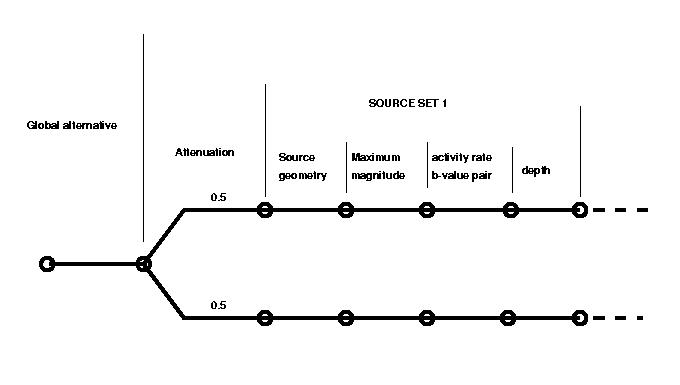
and Mc Guire, 1987). Two alternatives were used for the attenuation relation
(with equal weight of 0.5 each), two different depth estimates (10 and
30 km, with 0.4 and 0.6 weights respectively), were also incorporated in
the logic-tree as two alternatives. The logic-tree examples for the computations
are shown in Fig 5.
![]()
Figure 5. Logic-tree examples shown for the regional computations.
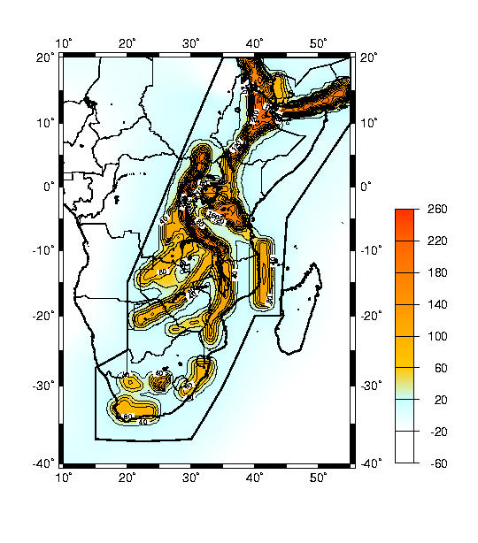
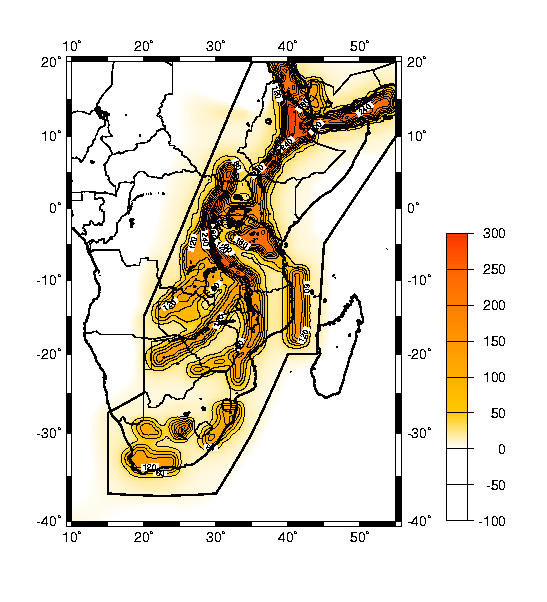
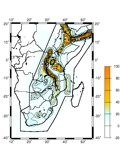
The results obtained from the hazard computations are shown graphically in figures 6 to 9. Figure 6 and figure 7 show the mean PGA values (in gals) for a 10% probability of exceedence in 50 and 100 years; figure 8 and figure 9 are for 50 and 100 years return periods. These figures show that high PGA values were obtained for all cases for the Western Gulf of Aden, Afar Depression, southern Sudan, Western rift and northern Tanzania. For example, high mean PGA values in excess of 240 gals for 10% exceedence in 100 years and 100 gals for a 100 years return period are obtained for the regions mentioned above.
DISCUSSION AND CONCLUSIONS
The high PGA values obtained for the Western Rift and the Afar regions may be attributed to the high seismic activity in the regions. On the other hand, the high PGA values obtained for Southern Sudan and northern Tanzania could be due to the occurrence of large magnitude earthquakes, in southern Sudan in 1990 (MS = 7.1), and in Tanzania in 1910 (MS = 7.4) (Ambraseys and Adams, 1992). The two attenuation relations used in this study give slightly lower PGA values when compared to previous studies. This is so, especially for those areas in the southern part of the region. This difference may be attributed to the different input parameters, different source zones and computational software used. Considering the fact that most developments within the region are concentrated along the areas of rifting and that the southern part of the region, though characterised by relatively lower hazard, is an area of incipient rifting, there is a need to assess the earthquake hazard, particularly in city and town planning and in the construction of high-rise buildings and water reservoirs. For the nine cities selected as special sites in this study, PGA values vary depending on the return period of interest and the degree of conservatism (i.e. the different percentiles). In this report several different sets of seismic hazard results were produced and presented. However, proper choice of the return period with the desired level of conservatism, is the end-user's (i.e. the structural design engineer, the city planner or the decision maker) responsibility. Furthermore, site specific studies presented here are only for hard rock conditions, and hence future studies that take into account soil type and local geology are necessary before a realistic assessment of the earthquake hazard can be made. Efforts should be directed towards investigating the attenuation relations for average soil types in the region. This, as well as the recently available spectral attenuation relations (Spudich et al., 1997), may be used in the future for improving the results.
Seismic hazard assessment
for the eastern and southern Africa region is an ongoing process which
will also continue in the future. In this respect, the regional probabilistic
hazard estimates obtained during this workshop represent the state-of-the-art
results and should be regarded as guidelines on a regional scale. On local
scales however, specific studies are needed. Detailed seismic hazard analyses
which already exist for some of the countries, will provide major contributions
to this end. Obviously, significant improvements may be achieved both in
local and regional scales, once the seismotectonic knowledge of the area
as well as the attenuation relations, are better understood. During this
study, some of the attention was also drawn into the seismic hazard related
to the major population centres in the region, where individual results
were produced. Earthquake hazard and risk for megacities in the region
as well as all around the world remain be a major challenge for the future
work.
ACKNOWLEDGEMENTS
Financial support for some of the participants was provided by the International Lithosphere Program (ILP) through the Global Seismic Hazard Assessment Program (GSHAP). We thank GSHAP co-ordinator, Prof. Domenico Giardini, for this continued support. The software used in computing the probabilistic seismic hazard (FRISK88M, Ver.1.70), was kindly provided by Risk Engineering Inc., of Boulder, Colorado, USA under the GSHAP. We thank Dr. Robin McGuire for his support on this. This work would certainly not have materialised without the financial support of the International Programme in Physical Sciences (IPPS), Uppsala Sweden and the untiring support rendered to the Group by the IPPS Director, Prof. Lennart Hasselgren in hosting earlier workshops in the region where the preliminary work was done, first, in Addis Ababa, Ethiopia in 1995, secondly, in Zimbabwe in 1996. Without this support and ground work, it would have been virtually impossible to carryout the hazard assessment reported here. We are also thankful to UNESCO and IASPEI for chipping in with some funding at various workshops related to the preliminary work on Seismic hazard in this region.
Data processing for the input
parameters were done using the software SEISAN. We are grateful to Jens
Havskov for making his software available to us. The director of the Institute
of Solid Earth Physics, Jens Havskov, is also thanked for providing the
facilities for the workshop and for his help in some of the computational
problems and to Bodil Helsengreen and Norbjørg Kaland, we are truly
grateful for their help in many practical aspects. Lastly, we sincerely
thank the participants of the Addis Ababa and Bulawayo ESARSWG workshops
who could not participate in the work at Bergen Norway (these are: Jamal
A. Abdulla, Robin Adams, Laike M. Asfaw, Daniel Ghebretatios, Isaac Marobhe,
Lovemore Masawi, Samuel Muchuku, Ian Saunders, Alice Walker, Harris Nyali,
Mubu S. Mubu, Ezra Twesigomwe, Ghebrebrham Ogubazghi, Andre Kijko, Thomani
Shumba, Patrick Ngulube, Ted Gumbi) for the preliminary work done upon
which we were able to build our study in Bergen, Norway.
REFERENCES
Abe,K, 1981. Magnitudes of large shallow earthquakes from 1902 to 1980, Phys. Earth planet. Interiors, 27, 1, 72-92
Abe,K, 1982. Magnitude, seismic moment and apparent stress for major deep earthquakes, J. Phys. Earth, 30 (4), 321-330.
Abe,K, 1984. Complements to Magnitudes of large shallow earthquakes from 1904 to 1980, Phys. Earth planet. Interiors, 34 (1-2), 17-23.
Abe, K and Noguchi, S., 1983. Determination of magnitude for large shallow earthquakes 1898-1917, Phys. Earth planet. Interiors, 32 (1), 45-59.
Abe, K and Noguchi, S., 1983. Revision of magnitudes of large shallow earthquakes 1897-1912, Phys. Earth planet. Interiors, 33 (1), 1-11.
Ambraseys, N. N. and Adams, R. D., 1986. Seismicity of the Sudan. Bull. Seismol. Soc. Am. 76, 483-493
Ambraseys, N. N. and Adams, R. D., 1992. Reappraisal of Major African Earthquakes. Natural Hazards 4, 389-419.
Ambraseys, N. N., Melville, C. P. and Adams, R. D., 1994. The Seismicity of Egypt, Arabia and the Red Sea, a historical review. Cambridge Uni.Press, 181p.
Asfaw, L. M., 1992. Seismic Risk at a site in the East African rift system. Tectonophysics, 209, 301-309.
Atkinson, G. A. 1984. Attenuation of strong ground motion in Canada from random vibration approach. Bull. Seismol. Soc. Am. 74, 2629-2653.
Baker, B. H., Mohr, P.A. and Williams, L. A 1972. Geology of eastern rift system of Africa. Geol. Soc. Am., Special Paper 136.
Boore, D. M, Joyner, W. B. and Fumal, T. E. 1993. Estimation of response spectra and peak accelerations from western North American earthquakes.: An interim report, US Geol., Surv. Open-File Report 93-509, 72p.
Boore, D. M, Joyner, W. B. and Fumal, T. E. 1994. . Estimation of response spectra and peak accelerations from western North American earthquakes.: An interim report, Part 2, US Geol., Surv. Open-File Report 94-127, 40p.
Bungum, H. and Nnko, A. A 1984. Seismicity and tectonics of the Stieglers Gorge area, Tanzania. J.Geophys. Res. 89, 1874-1888.
Båth, M., 1975. Seismicity of the Tanzania region. Tectonophysics, 27: 353-379.
Båth, M., 1979. Introduction to Seismology. Birkhauser, 2nd edition, 137-167.
Camassi, R., Mirenna, s:, Rebez, A., Sticchi, M. and Zerga, A., 1995. Problems and pitfalls in the compilation of comprehensive, parametric earthquake catalogues. Materials of the CEC Project "Review of Historical Seismicity in Europe"- vol.2.
Camelbeeck, T. and Iranga, M. D 1996. Deep crustal earthquakes and active faults along Rukwa trough, eastern Africa. Geophys. J. Int. 124, 612-630.
Campbell, K. W 1985. Strong motion attenuation relations: A ten-years perspective. Earthquake Spectra Vol.1, No. 4, 759-804.
Chapola, L.S. 1997. State of stress in east and southern Africa and seismic hazard analysis of Malawi. Unpubl. M.Sc. thesis, Institute of Solid Earth Physics, University of Bergen, Bergen, Norway, 143p.
Cornell, C.A. 1968. Engineering seismic risk analysis. Bull. Seismol. Soc. Am. 18, 1583-1606.
Constantinescu, L., 1980. Review of Seimological study of the earthquake of 4th March 1977 edited by I. Cotrnea and C. Radu, In Romanian, Studii Cerc. Geol. Geofiz. Geogr., Ser. Geofiz., 18, 195-198.
Der Kiureghian, A. and Ang, A. H-S. 1975. A line source model for seismic risk analysis. Univ. Illinois Technological Report, UILU-ENG-75-2023, Ureana, 134p.
Der Kiureghian, A. and Ang, A. H-S. 1977. A fault-rupture model for seismic risk analysis. Bull. Seismol. Soc. Am. 67, 1173-1194.
Donovan, N. C. 1973. Earthquake hazards for buildings, in building practices for disaster mitigation. Natl. Burr. Standards Building Sci. Series 46, 82-111.
Dunkelman, T. J., Rosendahl, B. R and Karson, J. A. 1989. Structure and stratigraphy of Turkana rift from seismic reflection data. J. African Earth Sci. 8, 489-510.
Ebinger, C. J 1989. Tectonic development of Western Branch of the East African Rift System. Geol. Soc. Am. Bull. 101, 885-903.
EPRI. 1986. Seismic hazard methodology for the central and eastern United States, Electric Power Research Institute, Report NP-4726, Vol.1, July.
Gumper, F. and Pomeroy, P. W. 1970. Seismic wave velocities and earth structure on the African continent. Bull. Seismol. Soc. Am. 60, 651-668.
Gutenberg,B. and Richter, C., 1954. Seismicity of the Earth and Associated Phenomena. Princeton Univ. Press, 310 pp.
Havskov, J. 1997. SEISAN (Version 6.0). Earthquake Analysis Software for the IBM-PC and SUN. Institute of Solid Earth Physics, University of Bergen, Norway. 236p.
Iranga, D. M., 1991. An earthquake Catalogue for Tanzania 1846-1988. Report No.1-91. Uppsala University.
Jackson, J. and Blenkinsop, T. 1993. The Malawi earthquake of March 10, 1989: Deep faulting within East African Rift System. Tectonics 12, 1131-1139.
Jonathan, E. 1996. Some aspects of seismicity in Zimbabwe and eastern and southern Africa. M.Sc. thesis, Institute of Solid Earth Physics, Univ. Bergen, Bergen, Norway, 100p.
Joyner, W. B. and Boore, D. M 1982. Prediction of earthquake response spectra. US Geol., Surv. Open-File Report 82-977, 16p.
Joyner, W. B. and Boore, D. M 1988. measurement, characterisation and prediction of strong ground motion, Proc. Earthq. Eng. Soil Dynamics II, GT Div/ASCE, Park City, UT, June 27-30, 1988.
Kanamori,H and Abe,K., 1979. Reevaluation of the turn of the century seismicity peak, J. Geophys. Res., 84 (11), 6131-6139.
King, B. C 1970. Vulcanicity and rift tectonics in East Africa. In: African Magmatism and Tectonics, T. N. Clifford and I. G. Gass (Eds.), Oliver and Boyd Publ.
Krinitzky, E. L, Chang, F. K. and Nuttli, O. W. 1988. Magnitude related earthquake ground motion. Bull. Ass. Eng. Geol. Vol. XXV, 399-423.
Kulkarni, R. B., Youngs, R. R. and Coppersmith, K. J. 1986. Assessment of confidence intervals for results of seismic hazard analysis. Proceedings, Eight World Conference on Earthquake Engineering, San Francisco, July 1984, pp 263.
Lazarov, R. and Christoskov, L. 1981. Statistical aspects of the magnitude-frequency relation for Bulgaria. Proceedings of the 2nd International Symposium on the Analysis of Seismicity and on Seismic Hazard, Liblice, Czechoslovakia, May 18-23, 1981, pp 56-66.
Maasha, N., 1975. The seismicity and tectonics of Uganda. Tectonophysics, 27: 381-393.
McConnell, R. B. 1972. Geological development of the rift system of east Africa. Bull. Geol. Soc. Am. 83, 2549-2572.
McGuire, R. K. 1974. Seismic structural response risk analysis, incorporating peak response regressions on earthquake magnitude and distance. Mass. Tech., Dept. of Civil Eng., Pub. 399, 371p.
McGuire, R. K. 1976. FORTRAN computer program for seismic risk analysis. U. S Geol. Survey Open- File Report 76-67, 90p.
McGuire, R. K., Stepp, J. C. and Toro, G. R. 1986. Seismic hazard and its uncertainty in the eastern U. S Proceedings, Annual Meeting of the Society of Risk Analysis, Boston, 1986.
Mougenot, D., Recq, M., Virlogeux, P. and Lepvrier, C. 1986. Seaward extension of the East African Rift. Nature, 321, 599-603.
Musson, R. M. W. 1994. The BGS Sub-Saharan African earthquake catalogue. British Geological Survey Technical Report WL/94/28.
Nyblade, A. A, Birt, C., Langston, C.A., Owens, T. J. and Last, R. J. 1996. Seismic experiment reveals rifting in craton of Tanzania. EOS, Trans. Am. Geophys. Union 77, 517-521.
Pacheco, J. F. and Sykes, L. R., 1992. Seismic moment catalogue of large shallow earthquakes, 1900 to 1989. Bull. Seismol. Soc. Am., 82, 1306-1349.
Poirier, J. D. and Taher, M. A., 1980. Historical seismicity in the Near and Middle East, North Africa, and Spain from Arabic documents (VIIth-XVIIIth century), Bull. Seism. Soc. Am., 70 (6), 2185-2201.
Reiter, L., 1990. Earthquake Hazard Analysis, Issues and Insights. Columbia University Press. 9-29.
Risk Engineering Inc. 1996. FRISK88M (Version 1.70). Users Manual. 4155 Darley Av., Suite A, Boulder, Colorado 80303 USA.
Rosendahl, B. R 1987. The architecture of continental rifts with special reference to the east Africa. Ann. Rev. Earth Planet. Sci. 15, 445-503.
Spudich, P. Fletcher, J. B, Hellweg, M., Boatwright, J., Sullivan, C., Joyner, W. B., Hanks, T. C., Boore, D. M, McGarr, A., Baker, L. M. and Lindh, A. G. 1997. SEA96-A new predictive relation for earthquake ground motions in extensional tectonic regimes. Seismological Research Letters 68, 190-198.
Sykes, L. R. and Landisman, M., 1964. The seismicity of East Africa, the Gulf of Aden and the Arabian and Red Seas. Bull. Seismol. Soc. Am., 54, 1927-1940.
Toro, G. R. and McGuire, R. K. 1987. Calculational procedures for seismic hazard analysis and its uncertainty in eastern U. S Proceedings, Third International Conference on Soil Dynamics and Earthquake Engineering, Princeton, 1987.
Turyomurugyendo, G. 1996. Some aspects of seismic hazard in the east and south African region. Unpublished. M. Sc. Thesis, Institute of Solid Earth Physics, University of Bergen, Bergen, Norway, 80p.
Twesigomwe, E. 1997. Probabilistic seismic hazard assessment of Uganda. Ph.D. thesis, Dept. of Physics, Makarere University, Uganda.
USGS/NEIC, 1994. United States Geological Survey, National Earthquake Information Center. Global Hypocenter Database (CD-ROM), EPIC Users Guide (Version 3.0), Appendix B, September 1994.
Vanek, J., Zatopek, A., Karneik, V., Kondorskaya, N., Riznichenko, Y., Sovaoenski, E., Solovev, S. and Shebalin, N., 1962. Standardisation of magnitude scales, Izvestia Academy of Sciences USSR, Geophys. Service, No. 2, 153-158.
Weichert H. D., 1980. Estimation of the earthquake recurrence parameters for unequal observation periods for different magnitudes. Bul. Seism. Soc. Am., 70, 1337 -1346.
Figure Captions
Figure 1. The rift system of eastern and southern Africa in its geological setting (modified after McConnell, 1972). The inset shows the map of Africa with national boundaries. The bold outline of the inset marks the boundary of the area for which seismic hazard was computed.
Figure 2. Seismicity of eastern and southern Africa based on the catalogue compiled by Turyomurugyendo (1996). Earthquake epicentres are shown for MS4.0.
Figure 3. The 21 seismic source zones used in the study. Note that zones cover basically the seismically active rift segments and areas where seismotectonic background knowledge is sufficient (see text for discussion).
Figure 4. The attenuation relations used in the seismic hazard computations shown together with some other known relations for comparison.
Figure 5. Logic-tree examples shown for the regional computations.
Figure 6. Distribution of mean PGA (in gals) values in eastern and southern Africa computed for 10% probability of exceedence in 50 years (contour interval is 40 gals).
Figure 7. Distribution of mean PGA (in gals) values in eastern and southern Africa computed for 10% probability of exceedence in 100 years (contour interval is 40 gals)
Figure 8. Distribution of mean PGA (in gals) values in eastern and southern Africa computed for a return period of 50 years (contour intervals is 10 gals).
Figure 9.
Distribution of mean PGA (in gals) values in eastern and southern Africa
computed for a return period of 100 years (contour interval is 10 gals).